Proposed Map: Domination 1941
-
Ah, the light at the end of the tunnel is in sight.
I posted the key over at A&A org to see if anyone has suggestions
Good idea!
-
No replies over there yet, guess it's just a bit quieter lately than the halcyon days that I recall lol. Probably just cause nothing has come out since Zombies and the Larry boards moved on to War Room stuff. Random aside, but Renegade said "A brand new site for Axis & Allies" was coming in 2023, so it'll be curious to see what kind of activity that drums up. They also said 'Fan involvement in selecting new themes to add to the line. New printings of staples for the line. The return of some long out of print editions' in their comic con press release. So that's kinda cool, if it pans out and doesn't get upended by recession-y woes. A 'return of some long out of print editions' makes me think they might just reissue the older map boards like for Classic or Revised. That'd be a cool one to do reversible, with front facing Classic reverse Revised for the mapboard or something similar. Maybe they will do the smaller tactical boards reissued as well. 1942, AA50, and G40 all seem like the staples to me. I'm guessing they also got 1914 as part of the deal, although that one didn't ever seem to catch on.
It's too bad cause WW1 is a cool theme. I thought 1914 had a cool box cover and cool sculpts, but the branding felt off. They should have just used the acronym "A&A" alone instead of writing out "Axis and Allies 1914-18 The War to End All Wars" cause it doesn't really fit to call the Central Powers the "Axis." But really I think it was the diamond shaped board that kinda tanked that game lol. Banging a knee or catching a hip to the corner of the table, I mean it just seems bad for business lol. Honestly if they just reissued that game with a more regular shaped board I bet it would do a lot better hehe. Anyhow, just a ramble cause I'm into the former Ottoman territories now. It'll be done by tomorrow I'd imagine.
I'm curious which blues you guys prefer for the oceans? I'm partial to a simple solid color myself. For me, if the oceans are too busy, it gets kind of distracting. Map blends allows for a more pastel look, so I prefer to have the base blue be somewhat darker/higher saturation, otherwise it tints pretty bright. Most of the visual effects I've seen for oceans end up looking more like clouds or wet paper, or else too busy with tiny waves that don't really do it for me. I think they look better as a solid shade of blue, but maybe just that's me. It'd be cool if the player could change the Sz color in the map properties by a HEX designation though, like they can with TT ownership colors. Just cause so much of the map is ocean blue, it really sets the vibe for the rest of the visual.
I generally use #6cccfe or #76cafd in the baselines I've made. For me Logan's Classic blue felt way too teal, and Bung's dark blue is a bit too midrange for me. Like with the map details/blends off I mean, cause when those are on the ocean just looks like clouds. As a player I'd like to be able to change that color on the fly, so it doesn't have to be such a one-size-fits-all situation. Right now the only way to adjust that stuff is to rework the baseline and re-chop the tiles, which is a lot of work just to change a shade of blue heheh. It'd be cooler if tripleA just painted the high seas color from the map properties the same way it paints the land tiles.
-
Ok here's the txt
Feel free to add or make whatever adjustments to the labels.
Base
https://www.dropbox.com/s/xnvwl23sf092dia/Domination_1941_baseline.png?dl=0Relief with White Borders (25% opacity)
https://www.dropbox.com/s/k0g0vwg2vf14vxb/Domination 1941 relief 25 opacity.png?dl=0HEX Colors used in the earlier key
Americans: 026400
ANZAC: 5ba399
British: 9e7035
Chinese: 533c69
Dutch: e77600
French: 0063a5
Germans: 656565
Italians: 6c4513
Japanese: e19521
Mongolians: a13030
Russians: 940000Let me know if I get em all hehe
Catch ya in a few! -
@black_elk
Ooh out of the tunnel, and now Im blinded by the shiny light of the goodies!
Thanks for all your hard work!Oh dear, now its my turn.
Hopefully I will have something to test late January.
-
Right on! Sounds good
Also here is the World War II Global 1940
Base
https://www.dropbox.com/s/4740bj0l87sbb57/World_War_II_Global_1940_baseline.png?dl=0Units
https://www.dropbox.com/s/pqkn53r1vzjj467/units.7z?dl=0I never got around to doing the Dutch and whatnot, but I think most everything we'd need to get a basic WWII game going is in there. We can come back later to fill in the gaps or fix anything I missed or whatever hehe. Just let me know if there's anything else we need.
Catch ya in a few! And Happy Holidays!
-
@black_elk
Just realised Shetland is in SZ 112.Geographically Im thinking it should be in SZ 111 B, what do you think?
Game wise I'm unsure, but Im thinking best in SZ 111 B ?
-
Sounds good. Makes sense to me for the gameplay too.
I updated the files in the links above for that adjustment just now.
-
@black_elk
I have been a busy zombie these past 2 days, well it is cold outside , centers.txt is populated, thanks again for your text file, it was invaluable and labour saving.
On to the polygons.txt
Bermuda is causing grief there is a split in the SZ line between 101 A and 101 C.Guatemala and Honduras both have something wrong in them, it could be
- a stray pixel
- not black pixels, so remove antialiasing
- or a border that the Polygon Grabber does not like and needs smoothing out/straightening
Its probably something on the border between the two?
As above for these;
St.Louis-Arkansas (probably not a border problem)
Brittany, Normandy, Poitou
Toulouse, Provence-Marseille
Most of northern Spain
3 areas of Portugal
Savo-Ostrobothnia & Helsinki
Netherlands & Belgium-Luxembourg
Natal, Praetoria
Aleppo-Deir ez Zor, Al Hasakah
Kurdistan, GilanThere are more, hopefully there is a pattern?
I will send the other half, when you post the updated baseline. -
I'm curious which blues you guys prefer for the oceans?
I like both #6cccfe or #76cafd, but if I have to pick one its #6cccfe. I too like simple backgrounds, the main event/eye candy are the units.
-
Progress! Right on! hehe
OK so I found line breaks in each of those spots you mentioned. In most cases it was a single missing black pixel along the border, go figure lol.
It's odd as I remembered fixing many of those, but I think what happened was I made those corrections on the paintjob as I was paintbucketing, but must have forgot to pull the lines back out again for the base after I was done. I found maybe a dozen other line breaks as I was scanning around, so fixed those where I saw em. It was mostly in the TTs I had adjusted more recently, so hopefully not too many more. Let me know if this one is still hanging up anywhere.
https://www.dropbox.com/s/xnvwl23sf092dia/Domination_1941_baseline.png?dl=0
ps. There ya go, I attached the right file link this time lol. Hopefully the World War II Global base is cool, as most of the pixel breaks I found were in the Domination subdivisions. Catch you in a few
-
@black_elk
Thanks!St.Louis-Arkansas @ 705, 2628
Castille-Leon @ 4629, 3181
Madrid-Cen.Spain @ 4630, 3179Netherlands & Belgium-Luxembourg no coordinates, but a hole in the border
Tsinghai no coordinatesSiberia @ 9906, 725
Evenika @ 9951, 1356
Krasnoyarsk no coordinates, but a hole in the border with EvenikaBroome-Exmouth @ 12079, 6804
Just under Arizona-New Mexico, right hand side of the map, is a triangle of land that is part of Monterrey, no coordinates, its part of the wrap around. This is my first wrap around map so I cannot offer any suggestions.
Do/did the coordinates help?
.
Also @ 0-355, 8084 thicker black line than the rest (just an observation, its not part of the Polygon Grabbers errors) -
Very helpful! Ok here I nixed a pair of floaters and closed those holes you mentioned. For the life of me I couldn't find what was up on the Belgium border. I just erased and redrew the line thinking maybe it was an off black somewhere somehow. Anyhow fingers crossed let me know if it flies.
https://www.dropbox.com/s/xnvwl23sf092dia/Domination_1941_baseline.png?dl=0
Ps. For that border with Texas/Mexico I just erased the line to fold it into the New Mexico Arizona tile, updated just now. Hopefully it works.
-
@black_elk
Absorbing the triangle worked.Well done, all the major TT pass.
Next islands and the SZ.
.
There is a minor imperfection around 16808, 3766, you might want to resolve, but no rush on that. -
Sweet!
Ok got that one too, must have been a slip of the wrist or something hehe. Updated the dropbox file linked above.
-
@black_elk
Fab.
There is just under 100 island/SZ polygons missing, it will take me hours/elapsed days to fix these, so hopefully by the weekend/Monday, I will have some more fixes. -
@Black_Elk
Nah, I fibbed. (Had some unexpected free time, so I put it to poor/good use )Have some more to be fixed;
001 A Island @ 15766, 1580
019 A @ 11850, 3943089 C @ 1695,4372
089 D @ 1695, 4372 (the same, so probably a border problem) -
OK I nixed that floating pixel and the island. For sz 89 the border was short by a pixel at Venezuela. Updated the dropbox file. Let me know if there are any more on the hunt.
-
@black_elk
Ok, they worked !So for now that's the baseline/baseTiles map hopefully done.

Im on to code type things like unit placement, connections and then integrating your map parameters with my code.
-
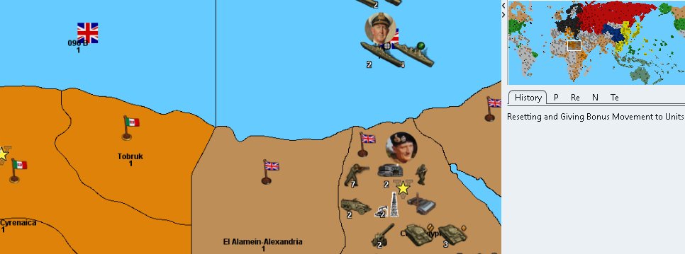
@Black_Elk
Please look at the map colours for Italy and Britain, on my mini mapl they are not easily distinguishable?Also look at the mini map, Italy owns most of the Horn of Africa and Britain a strip of countries down to South Africa.
.
-
@Black_Elk
Request for an Oil-Field / Oil Rig / Nodding Donkey/Pump Jack icon.To represent an Oil Field, this is my temporary version

.
In game it looks like this

.
Could you either beautify this one or do another icon to represent the above?On the reliefTiles I think we need to make the Panama & Suez Canals clearer/bigger?
Code-wise these are the canals
Danish Straits     112-113, Juteland & Copenhagen-Denmark
Gibraltar Straits  091 A-092, Gibraltar
Bosporus Strait    100 A-129, Ankara & Istanbul
Dardanelles Strait 099 A-129, Istanbul & Smyrna
Panama Canal       064-089D, Panama
Suez Canal         081-098, Cairo-Egypt & Sinai
How best to represent canals? (Frostion's barriers don't do it for me)
On the reliefTiles we could have a layer with;- On the border of the two SZ we could have a deeper blue dashed or dotted border
- On the land TT we could put light houses like this,
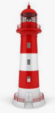
Thoughts?
Hello! It looks like you're interested in this conversation, but you don't have an account yet.
Getting fed up of having to scroll through the same posts each visit? When you register for an account, you'll always come back to exactly where you were before, and choose to be notified of new replies (either via email, or push notification). You'll also be able to save bookmarks and upvote posts to show your appreciation to other community members.
With your input, this post could be even better 💗
Register Login