Mega New Elk WIP
-
No git just the xml and the other stuff.
Name changes
Krakow
N. Italy
Rome
S. ItalyCan make rome just Italy if you want. They're almost same charachter length.
Moved the notification to fire after tech for working purposes. Switch it back when we're done.
@wc_sumpton here's just xml it's in the above as well. This is off of 1.36.1
-
Why not Milan (N. Italy) or Naples (S. Italy). There are approximately 150 hyphenated territory names. If you want, I can provide you with a list. Or I can "select" just the first/second part (I would use Excell to do it automatically).
Just curious about how you would handle this.
Cheers...
-
That'd probably be the way to go. Also might catch the sp errors in review tab if any left over. I don't have it on this rig, I cheaped out on Office when I got the new laptop hehe. But the auto wizardry would probably work to at least knock em down to just the one name, and then maybe can see that way if any others had a typo in like a one fell swoop.
")
-
@black_elk said in Mega New Elk WIP:
I don't have it on this rig, I cheaped out on Office when I got the new laptop hehe.
Same, but there are online port of office that can be used for free. This is what I use.
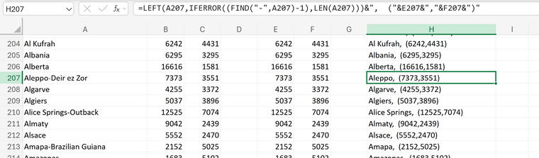
Please note that he formular bar at the top show the formular used to only take the left most portion of the name, Aleppo-Deir ez Zor, is just Aleppo. This is setup to be able to change all x,y quadrantes with single entries in column I1 and J1.
I've been using this to change name_place and pu_place uniformly.
Just wastin' time and having fun.
Cheers...
-
If someone wants to change all the names, that'd be great. The long hyphenated ones don't work imo.
Ideally the names are done first then PU then place.
No point in doing any place if the names are just gonna keep changing.
You guys let me know when they're done and I'll do the place then
-
I'm super content to pass the buck on this one as well
I mean when I keyed it out initially I wasn't sure of the conventions to be used, mainly on account of wanting it to harmonize somehow with G40 and those labelling peculiarities.
So for example, in Global you might have a name like say "Western Germany" then another simply called "Germany" and then yet another called "Greater Southern Germany" etc.
Or similarly "Poland" right next to an "Eastern Poland." Then elsewhere you might have a spot called say "Libya" and then "Tobruk" or "Egypt" and then "Alexandria" when the latter is a much smaller locality within the larger region but they're treated separately. To me this all seemed not particularly consistent, frequently conflating a smaller region with a larger region, lacking in specificity and often redundant.
I mean it works I suppose, or seems less jarring when the territories are fewer in number, but you get into this situation we're in now. When dividing tiles again, I think different naming conventions might have suggested themselves. Whereas now it's not Poland and Eastern Poland anymore, instead we have what would be Poland divided into 7 or 8 tiles, to the point where it starts making less sense to call any one of those tiles just "Poland" even if its the regional capital around Warsaw because it makes a much larger region seem like a much smaller metro. Hence the use of hyphenated redundancies there to clarify. I assumed one name would probably get subsumed into the other after feedback. Or like the Highlander approach of "there can be only one!" heheh
Then we also have other conventions where instead of dividing tiles I added them together from the Dom map. So if I had Italy divided into 20 some odd provinces, I probably picked the two names that were farthest apart geographically within a given tile, and added a hyphen between them when collapsing.
Using the G40 comparison with Germany, Eastern Germany, it might make sense to divide Italy into N. Italy, Italy, S. Italy, but then I also feel like that's not doing a lot of heavy lifting in the geography department for adding to the memorization index. I mean it's a bit like Northwestern Europe of 1942.2, which is replaced with Holland Belgium, and also Denmark, and a sliver of what would be Western Germany on the G40 board. Northwestern Europe while an ok technical description for the tile, didn't do us much good when going up to the more divided out thing. So sorta a similar issue here, where the older remains might not make as much sense when adding in a bunch of new tiles, and so the search for maybe better names as we go down. The larger regional names cease to make sense. I mean we used to be able to get away with Eastern Europe and Western Europe, now it's more legwork.
Other times there was probably some thematic reason for choosing names initially based on the earlier period. So for example maybe it made more sense to say Istria or Zagreb, as opposed to say Slovenia or Croatia, because of the way that G40 (or Hepps) sometimes used a metro name rather than a larger region for reasons that might have made sense for the period/board. For example on the G40 board we get Tobruk instead of Cyrenaica. These are locations in Libya, or Eastern Libya, but Larry didn't name it Western Libya and Eastern Libya. He used Libya, and then Tobruk, which can be a little confusing I think, although that was the convention we got handed there.
When I see Tobruk, I don't have many associations there outside of a WW2 context. Whereas Cyrenaica I can go back like a couple thousand years in time all the way to the Roman empire, and everyone still calls it that. But then there is probably not some famous WW2 Hollywood movie featuring Cyrenaica, and so everyone scratches their head on that one, whereas Tobruk everyone says 'oh ok I guess WW2 then, I remember that movie.' hehe I mean not to go for the lowest common denominator here, but it's a bit of a cliche that American highschoolers are terrible at geography. So guilty as charged here, although I'd probably dispute the characterization. Part of the point would be, if someone doesn't know or recognize something immediately, maybe they just need a more detailed Axis and Allies or Risk map to help fix that spot in mind, and to help get us over the hump here. I'm pretty sure I wouldn't know where say Novosibirsk was, if not for A&A. Just like I probably wouldn't know where Kamchatka was, were it not for Risk - that sort of thing. I mean there's that whole Seinfeld Newman joke about Ukraine on the Risk board, so we know that this is all a bit fraught right. You can sorta see the dilemma here, particularly for somebody like me, who is also somewhat indecisive about these things. So yeah, I'm all for just strongarming it across the finish lines.
")
-
Well at least @Trout 's kid Pizza kickin ass in geometry lol. Yea only reason I know where Kamchatka is, because of risk lol
Although after the soviets imploded, I did get a job offer to go there when in Alaska.
Actually thought about it, but I was happy enough where I was and I woulda had to leave the dog behind
-
Sorry, this took me so long:
UHD WIP 1940-45-1.36.2.zipUpdated xml, place, polygons with no hyphenated names
#centers old centers with no hyphenated names
centers, name_place, pu_place with no hyphenated namesAfter I removed all hyphenated names, I tried using Excel to balance out some of the names and PUs. This was not working as I had wanted. So, I loaded the map making utility and loaded the centers file. With the map also running, I could see where information looked out of place, so I would change those locations using the center-picker, save the changes (not closing the picker window). Copy the center file over the name_place and pu_place. Then reload the map. Etc... Etc...
I think this looks pretty good. I can still retrieve the old name_place and pu_place if that is what is wanted.
Cheers...
-
@wc_sumpton Looks Fantastic! Excellent work!
We can lock in around that for sure! Aces
-
So, once we settle on the name locations, some names like Washington D.C., San Francisco and Sydney Canberra are very long and the PUs or VC star seem missed place. These can be adjusted to look like:
UHD WIP 1940-45-x1.36.2.zipcenters, name_place, pu_place, vc files to show how some locations can be adjusted.
-
I copied all the flag/roundels, added "_large":
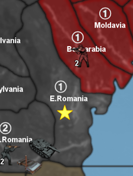
Now capitals don't look so bad. I also nudge E. Romania:

But Italian Somaliland really gave me troubles.Still, it was all fun!
Cheers...
-
@wc_sumpton Looks excellent to me!
I took a big long nap, just woke up to this and grinned, cause it's nice and sharp
I think the Frostion flag pucks look pretty good at that size! It's also possible for the Capital markers to utilize the Decoration place, if we wanted a different graphic to display for National Capitals (often the vanilla games will use the standard Air Roundels from OOB for that) though I preferred the designs that suggested more the national banner, and Frostion's flag pucks looked pretty clean in the UI menus, so I used those. I modified some of these when I did the tinted units, like to fix the star spangled banner so it would have the 48 star field, and a few others to look a bit more period. Should be good to go. It pretty easy to change flag graphics, or to switch settings in the props. I've encouraged peeps to try different Hexes as a why to stylize to their custom tastes, although I'm not sure many players would delve that deep, probably they'd just roll with whatever defaults we provide for map.props. Or also, if we wanted to preserve the option to use 'hidden capitals' for things like indicating to the Hard/FastAI which territories to prioritize, or if wanting to keep the display for those invisible via map.props. None of these are in effect right now for this board. The latter approach was used in the other map, although I'm not terribly familiar with that stuff under the hood. Also not sure how such hidden capital sea zones or territories would be weighted compared to actual capitals that do the cash capture/thing? The other scenario didn't use a capital cash capturing mechanic, so it wasn't impacting that at all, but it might be an issue if the computer was say weighting a capital like Moscow in the exact same way as some less critical hiddencapital territory or sz. Or similarly if it's like an all or nothing thing, where cash trades hands over those hidden territories too, which would sorta undermine the preeminence of the national capital in standard play. Here it's sorta necessary for how France is set up to fall on G1. Like if that attack were to fail basically Axis would instantly lose the game, hopefully not one the computer will be edging hehe.
In the standard maps all other mechanics are subordinated to the capital capture dynamic, since it's the most impactful thing that can happen in those games. It supersedes VC control, TUV trade, and just about every other thing that a player might be focusing on, since as soon as a capital trades hands the board resets dramatically, or the game simply concludes if the opponent cannot trade capitals elsewhere in the same round as an offset. Either way though we got the option, if exploring other methods outside the capital cash thing or some lesser bonus awarded perhaps (say treating all VCs as mini-capitals for a smaller pile) though again those would be novel House Rules type approaches from the standpoint of the vanilla games.
Heheh yeah I agree some of those names can be rough, particularly when it has the long national qualifier up front. I think perhaps a convention which abbreviates Br. for British, Fr. for French, It. for Italian in territories where that might make sense. There are only a couple such spots left on the board now, but examples would be like It. Somaliland, Fr. Somaliland, Br. Somaliland, or Fr. Guiana. and Br. Guiana. then we got Dutch Guiana as well. Other options might be Djibouti, Berbera, Obbia etc. Then Cayenne and Georgetown (Guayana), or Paramaribo (Suriname). If wanting to use the more metro type labelling. Though the space savings there would be sorta minimal. I think the abbreviated thing would work well enough. Could be used elsewhere for spots that make sense, and if the abreviation is sorta obvious. Say something like Gbr. for Gibraltar or similar. In cases like that it might make sense to use the labelling system of tripleA with separate label graphics for only those spots, so it'd still display more fully on cursor over, but then we run into the old issue of not being able to use font-size dynamically, since graphics are locked at whatever dimensions. I think prob the more simple text and just using abbreviations sparingly. Example might be something like D.C. for 'Washington D.C'. or situations like that if it gives nice space savings.
-
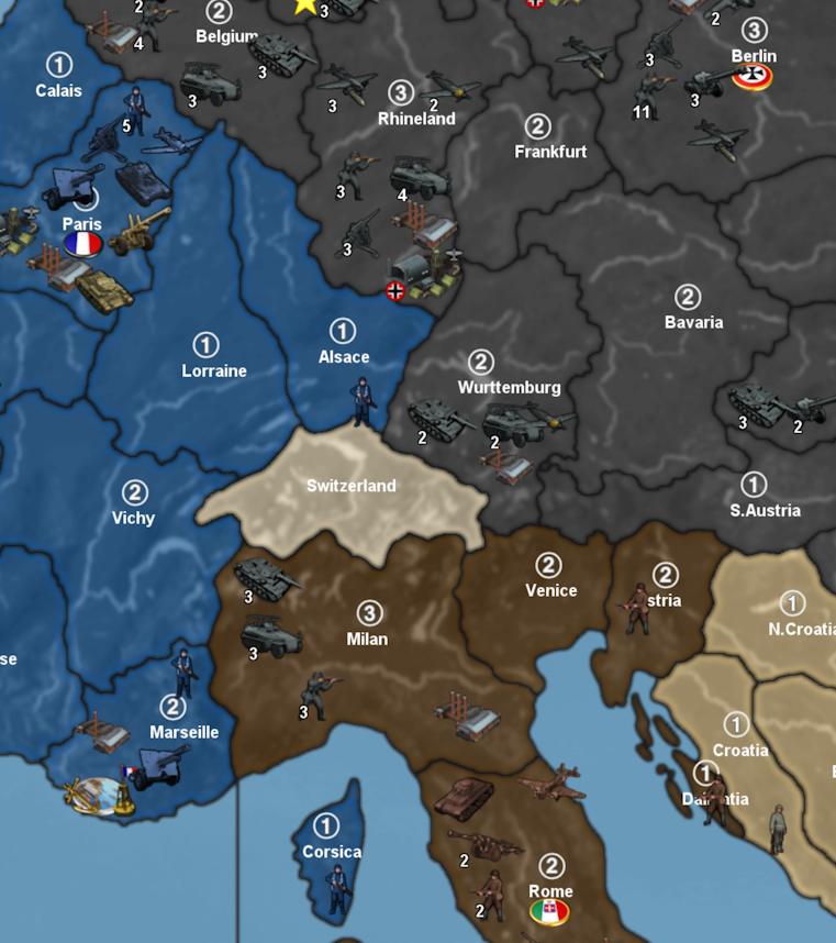
Territory name changes; French/Fr., British/Br., Italians/It., Dutch/Dt., Northwestern/NW., Cen./C. they may have been some others.
harbor change: "isAA" this will allow harbors to occupy the first place in place (thanks @TheDog).
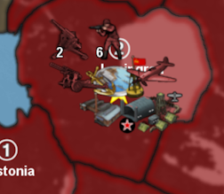
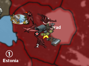
The first picture show Leningrad as it is pictured now. The second picture is with the "isAA" update and an updated place.Most 2/3 PUs shore territories would need to be check. Lot of work.
Cheers...
-
Looking boss!
I was going to knock out some of the VCs last night, but then I got completely distracted after finally updating to GIMP 3.0 hehe. I had been foot dragging on that one, since every time there will be UI updates which throw me for a loop, like the little tooltip toolbars and such, or pluggins hiding in different places. Just trying to get ahead of things, as it will surely come in handy if I have to rework any reliefs. Anyhow noticed when firing the new one that a couple of those VCs hopped out from their hiding place behind a naval base. Nice!
I think for most of them, the VCs that is, it's just a little bit of a nudge here or there, say to be nearer the coast if a coastal city. Since most TT tiles are relatively small, usually the centered VC isn't too far off. Amusingly Honolulu did fall in the right spot, so dodged that bullet. In various OOBs of the past, Honolulu has been left off the list before, or misprinted on the board in the wrong island to some chagrin there, where updates to physical boxes or cards can take a while. Thankfully we don't have to worry about an actual print run haha. Shave ice for all!
For VCs I think probably I just need to do all of them at some point, even if the default location (near center) looked ok and didn't need an adjustment really, just to have them all in the coordinates list there for the VC txt. When I suggested to ballpark by just doing a copy/paste on the center or name VC coordinates initially, that was only cause I couldn't recall where they positioned relative to the center by default, but looks like it typically would be like 36 px lower than the center for that. Probably just the size of the images veq/bung were using for that. Anyhow looks clean! Names looking great! Nice work!
-
Some set up adjustments I'm considering based on the latest.
Switch the VC from It. Somaliland to Mogadishu, It. Somaliland to 1 PU, and Mogadishu to 2 PU. It's slightly more protected with two warfronts on land instead of three. This spot is a bit of an anachronism for the 1940 start date, but with the whole idea of turn 1 = recap turn, I think it'd give a nice flavor and serves as a base of ops for Italy/Axis on that side of the map, sorta largest metro for that corner. Also if Axis can someone hold, or recover it, then it serves as a nice secondary base beyond Cairo for them. I imagine some tension there as Axis, if Cairo is taken over, between whether to drive overland towards Baghdad, overland or by sea to the Italian spots in East Africa, or directly onto India or South Africa by sea. But then the reverse some tension for Allies about which spot to mount the critical attacks or pull back defense.
For that I think it makes sense to push the factory_minor over from Madras to Bombay. Keeping the values the same since Bombay is currently worth 2. I think New Delhi could remain the second VC and also remaining at a value of 2. This spot wouldn't have a starting factory but be factory capable. This to capture the classic build strategy of Classic and Revised, or whether to place a secondary factory in India. Generally a high risk high reward type proposition, where if it works Allies can wedge, but if it fails then Axis have another springboard. So anyhow I think New Delhi can work like that. At the m+1 Distance this means the UK will be slightly more oriented on Africa and a bit less on Burma push from their Bombay factory. Madras had more of a slam back and forth into Burma vs Bengal, so like UK and Japan clapping into those spots and Calcutta from the factories at Madras. Also UK playing very forward vs Japan from that position on the water. I think it might be helpful though to split that placement into the sea zone off Calcutta, which moving that second factory to Bombay would achieve. I think airbase could move Bombay as well, naval base could remain, or move to Ceylon maybe, just to keep each tile interesting. Maybe encourages some exchanges and forward fleet actions. Basic idea would be to move the main resupply into the Indian theater over a bit, and have it focus a bit more on stretching supplies up from South Africa or East Africa (more protected sea zone movement) vs being right on top of India trying to hold the line with their fleet vs Japan. This would create more of a deadzone for that between region from like Bombay to Singapore on the water or vs scramble/coastal air umbrella, and put a bit more distance from the Dutch East Indies. I think should work at any rate.
I have a few other edits I'm trying, will report back with any other ideas
-
Would like to make a GitHub push. I've moved the player\units factory images, plus other common use images.
Cheers...
-
Sounds good to me
I didn't have quite as much time to mull over things as I'd planned, got stuck running errands instead. But tried to do a quick list of things this morning that I need to do still. I saw when looking at the stats that VC disappeared from that column, but maybe was just on mine. When the Git gets updates I can dive in from that one.
Random ideas kicking around last night. First idea was that, for larger regional labels, I might do something separate for that and use the decoration place there. Perhaps just for some of the larger areas to clarify. So for example we might have "FRANCE" or "GERMANY" with a semi transparent font that way in all caps, and displaying over multiple tiles, in some spot where the demands of the starting unit place are less pronounced. Similarly for some of the many territories and island groups that we further sub-divided we could do the same. I'm not sure if it's necessary to go too ham here, but it may help in a few spots. For example a larger label that just says Libya, or India, or Sumatra, or something like a callback to the smaller boards. I would table this for now, since it's not anything critical, just a decorative element. But while I was quickly scanning the board had a few thoughts around the factory capable 2 PU spots.
As I recall, the computer has been much more reluctant to buy factories ever since the tripleA 1.9 thing where they stopped buying them altogether. I think this was resolved for the standard factories (placement capped at production values), but not sure if it was also handled for the G40 factory types, where the production value is decoupled from the max place, ie. factory_minor 3 place factory_major at 10 place.
To me the bread and butter of having these things, would be when one side or the other is trying to stretch their logistics into the next potential theater of operations- to provide a couple 'hurry up' spots at the end of those longer logistics lines. So that when the player finally does arrive, they have a way to establish new production toeholds nearer to the main fronts. This was part of a general idea that if we could make the AI somewhat less transport dependent to push it's fronts, that this would allow the computer to play a somewhat stronger game. I think also for the deep endgame, it can be entertaining, for stuff like invasion USA antics, which would likely never occur in a standard PvP, but which in a solo could provide some definite entertainment value. In a regular game sometimes it's a courtesy to play out a final round, so the opponent can do their big buy with stolen cash, but more often that'd be the point where their losing player bows out. The computer on the other hand never quits, so this is a way for players to sort of reset their production fronts when the game gets to that point (usually not for many rounds.)
I think a good example of this would be South America in an endgame where Axis are ascendant. Perhaps after Moscow or London falls Axis turn their attention further West to start thinking about a swing over towards Brazil, with the idea to sort of inch up closer towards North America. To make this worthwhile I think having a production capable tile there would be good. This would not typically happen in a normal game, since the region is more out of the way and not on the winning line for movement for either side really. Sure USA/Allies might try to build a factory in Brazil, but this is usually a waste of cash for them traditionally, since they have more productive spots already housing factories, and the distance from those to the warfronts is mostly similar to the distance from a newly minted Brazilian factory. By the same token Axis aren't typically going to target because they know the USA will just immediately stomp back in PvP hehe.
The computer is more cautious though, so it will sometimes allow the player to make a big brazen move into the Guianas or Brazil, and for that I like the idea of maybe Rio or Dt. Guiana as a minor capable at 2 PU value. It's not that those spots with minors could replace a logistics line, but more to support an ongoing press that's already coming from backfield production. Also the computer is just very unlikely to do what human player might do in the deep endgame, purchasing factories in all peripheral contested spots and then immediately just spamming them with infantry and sending fighters before the enemy can build up/position the transport or carrier capacity to deal with that. In a PvP probably the opponent would just quit, seeing the futility of fighting on vs a player who's willing to do that. Just the spam and stack. It's the sort of thing that wouldn't make sense until after the center of the board has collapsed, but examples would be the way in which Japan or UK can just stack to the ceiling if they concentrate round to round and become virtually unassailable as island fortresses. Other spots in the standard games can work this way as well. Dutch East Indies being an example, anywhere with a high placement to production ratio. Territories on land at choke points are similar, say India, but it's nowhere so extreme as on single territory (actual islands in A&A terms) where 1 TT is completely contained within 1 sz and also is factory capable. This is in part why G40 has that rule about factories on islands, but then it as violates it's own rule with Japan, so I don't know but it's a thing. Here the entire rationale of the further subdivisions (beyond fun m3 movement stuff) is to help mitigate that issue somewhat. Like the whole idea of having a sea zone boundary strike across a territory, particularly where the larger islands are concerned. Basically because we want to encourage the island hop in this one, even if bypass is sound, battle is fun, so we lean into it by giving all those spots some skin in the game for production values, but then take away with the other hand by making only the 2 PU spots actually viable for Factory build antics.
Short of it is, probably we try to keep to a single 2 PU zone for certain island groups, or where possible to split these across 1 territory or 1 sea zone where possible, just so no one spot in the local region becomes the be all end all. Instead we want the back and forth, or some pick and choose between which productive spots to gun for. Some spots we reduce from 2 to 1, so as not to see too much over stacking. It's an abstraction in terms of relative production scale, to service the gameplay. We already have this going on with coastal Europe where some spaces have their production value held lower at 1 to avoid the ultra stack/factory spam everywhere), and because the M+1 is pretty potent. Factory_minor is relatively inexpensive at 12 PU cost, at least for the nations that collect heavy, and movement in a turn based game is key, so I think there is more incentive here than in vanilla to be buying minor factories. Especially with mech/tank operating at the M3 distance from such a spot, they become very powerful pockets wherever a minor factory can be supported. So probably need to be careful where we double up, or allow a multi factory build strategy that can support a much larger push of HPs into a concentrated zone (say vs India or like Japan/UK home waters) as would be the case traditionally from the Dutch East Indies. So like where USA is gunning to take those over because it is more productive (more placement capable under the vanilla factories.) This sorta distorts the playpattern where Japan and USA are constantly trading the Dutch East Indies instead of the spots in the central Pacific where the fighting took place historically. So here again, the whole idea of production is abstracted based more on the place needs to keep a balance going between sides. For example USA takes out Truk, but then Japan has a fallback position. If either player starts buying factories, the move is typically to respond in kind and mimic, or else break the opposite direction try to take the factory over, use the current HP advantage in the press (since it takes a round and opponent has to telegraph the factory buy in advance) the idea being to use regular purchasing and stronger logistics to seize the newly bought factory and then use it against the dude who bought. That's the double edged sword on the factory that can't be destroyed, and the inherent risk to buying the new ones.
Anyhow thinking about that I was considering maybe we might reduce a few spots from 2 to 1 or raise from 1 to 2, just based on how the computer/player might push. Sorta like the Bombay thing, and then trying to have a more protected contested East Africa, since we know both sides tend to end up there either to hold or pressure Suez/Africa fronts. Overall feels pretty good though. I think it's mostly on the margins just to make sure everyone has sufficient hitpoints/placement spots around the board for the hotspots where we want the action to sorta coalesce around those pockets.
Should be fun! It's nice to see the clean read coming to fruition. Looks pretty solid to me
-
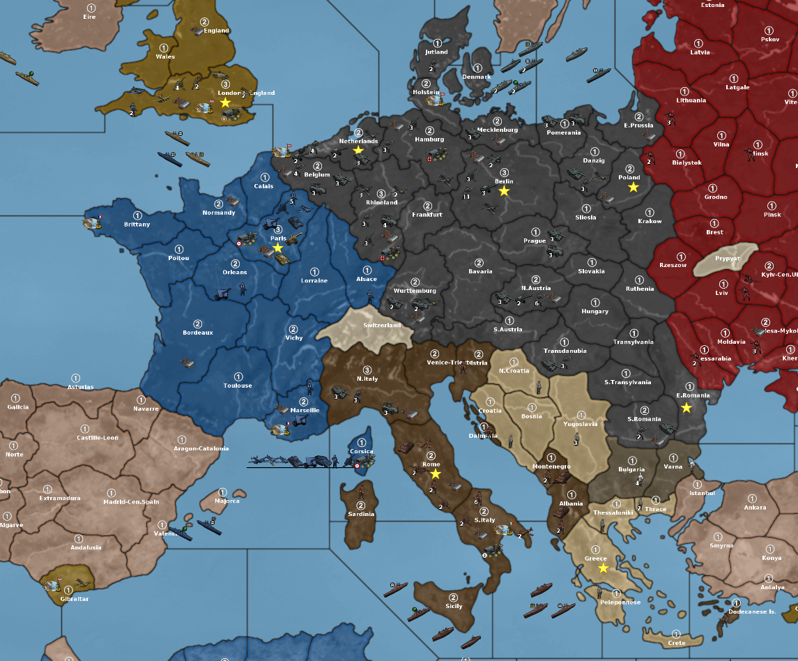
version 1.37 is ready (Thank you @beelee)
The Mogadishu/Somaliland and Bombay-Ceylon/Madras change have been made.
Cheers...
P.S Just notice that there is a factory_upgrade in New York for the Americans. It should replace itself at the end of the Americans first turn, and will be replace hopefully in the next xml update.
Cheers...
P.P.S Forgot the map.yml which has now been updated.
Sorry
Cheers...
-
@black_elk said in Mega New Elk WIP:
I saw when looking at the stats that VC disappeared from that column, but maybe was just on mine.
Nope, sorry, that was on me. When I wanted to look at the capitals I turned off VC for those cities. To retrieve that column would mean to turn on VC's for the capitals which would have those stars covering (or almost covering) the capital symbol.
What should ever I do... Hide the stars! He He He He He!
UHD WIP 1940-45 1.37.1.zip
New York changed to factory_major
capitals are now VCs again
map.yml (in case you need this)
vc.txt with the hidden starsCheers...
-
@wc_sumpton Hehe I just got home from pin balling around and fired it up. Looks great! Excellent work