North Africa - TripleA Module
-
Yeah I have no idea really where the v3, v4 etc World War II nomenclature came into it. Veq made all those shot calls I think when restoring tripleA, after the dark times when the site went down for like a year with no boards to speak of. Prior to that all the maps had names similar to what you're suggesting as I recall. Production units were called IPCs etc. Using the internet archive for the Way back machine might be able to pull up what the old labelling was, but that was in the old nabble and sourceforge days I think. I think the warclub actually has more consistency over time, among the main sites, since that one goes back to like 2005 I'm pretty sure, but I know there was a migration there at one point as well. Probably in like the late aughts. I can't remember but there were a couple.net and .orgs in there. I can't really remember em all, but the boards migrated a couple times for sure and a couple big resets where like everything was just sorta lost from the old forums. When all the lights came back on all the maps were separated off into a depot, with those sorts of names and the restyled map designs that Bung created for some of the more recent boards. I think the current era goes back to 2012 with this https://www.axisandallies.org/forums/topic/17032/triplea-map-for-global-1940-alpha-final?page=1
Panther was around and might recall better than me. That was an era where RL and work was just grinding me down to nothing. I didn't pick it up again till a few years ago, mostly on account playing a bunch of A&AO for a few years there, and the pandemic freeing up a bunch of time hehe.
I agree though it's sorta confusing, and definitely stacks up the Ws section making it harder to find stuff. Not sure what's best, on the git there's a bunch of stuff but then it's easy to get lost in there. I also have to check those lists usually, or Roger's logs to get my bearings and remember what stuff was called, cause he's got those extra screens and notes for a quite few. I had forgotten a couple, like that cool WW2 map that dagon made with all the trenches and such for the oceans. It's a little high vibrancy, but when I ran it on blends looked very nice I thought. And of course some of those Hepps maps and the other favs. For WW2 definitely quite a few scenarios to choose from.
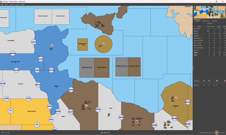
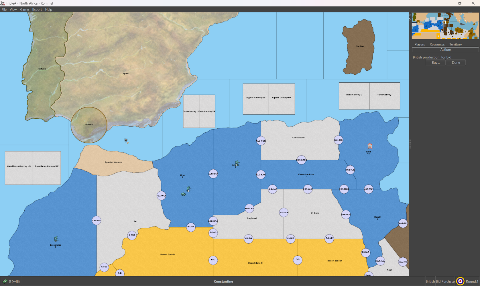
I like North Africa myself, seems simple to remember
")
-
ps. here's a quickie relief if you want something to riff on. Basically I just did a marble pattern fill at like 30% opacity for the land. You can change it to a topographical looking thing by finding a terrain type image and resizing stuff in sections. Like doing Spain or Italy and kinda stretching stuff till it fits the warp, or something similar for the ocean area, with a border fade across like 3 pixels. I was just eyeballing it at 50% view.
Looks like so, basically the default Hex but with like 30% opacity makes em display slightly lighter through the pattern. Could be anything really, whatever looks cool. But just for a bare bones looked ok to me at 1600p.
Here is the same busted into tiles
https://drive.google.com/file/d/1O5ssVhzoC3F4z1l7crvh1dZJPln08klp/view?usp=sharing
I think you'd just need to switch 'has Relief' from false to true in the map.props
-
@black_elk Oh man THAT looks cool! Thank you so much!
-
@victoryfirst said in North Africa - TripleA Module:
Thanks, we were having some trouble dealing with unlimited placement. For example, we weren't able to place in other player's territory, only in territories you control. Is there a way around that? That's the reason why each convoy zones consists of two zones so that both players of an alliance can place units directly in the convoy zones.
I understand this, which I think is a good idea. Units then should have their placements limited to these areas and the staging areas during phase 6. The only units that can be deployed after purchase phase 2 are German subs to SZ 1, which if connected by a canal to Tunis Convoy G, will allow the placement of that unit.
	<!-- <connection t1="SOK-ZEL" t2="Sokna"/>
	<connection t1="SOK-ZEL" t2="Zella"/> -->
	<connection t1="Sardinia" t2="Sea Zone 9"/>
	<connection t1="Sea Zone 1" t2="Tunis Convoy G"/> <!-- Canal Submarine deployment  -->
	<connection t1="Sea Zone 1" t2="Sea Zone 2"/>
	<connection t1="Sea Zone 1" t2="Sea Zone 3"/>
	<!-- <connection t1="Sea Zone 1" t2="Spain"/> -->
	<connection t1="Sea Zone 2" t2="Sea Zone 3"/>
	<connection t1="Sea Zone 3" t2="Sea Zone 4"/>
	<!-- <connection t1="Sea Zone 3" t2="Spain"/>
	<connection t1="Sea Zone 3" t2="Spanish Morocco"/> -->
I've commented out all mine zone connection because it seems easier to work without worrying about them right now. Also any connection to an impassable territory was commented. I added connection for canals with comments and commented out connections between convoy zones.
<!-- Canal used to deploy German sub to SZ 1 --> <attachment name="canalAttachmentGermanSub" attachTo="Sea Zone 1" javaClass="games.strategy.triplea.attachments.CanalAttachment" type="territory"> <option name="canalName" value="German Sub"/> <option name="landTerritories" value="Oran Convoy US:Tunis Convoy G"/> <!-- Canal will never be open for use --> <option name="excludedUnits" value="none"/> <!-- All units must be validated block Air and Subs from freely using canal --> </attachment> <attachment name="canalAttachmentGermanSub" attachTo="Tunis Convoy G" javaClass="games.strategy.triplea.attachments.CanalAttachment" type="territory"> <option name="canalName" value="German Sub"/> <option name="landTerritories" value="Oran Convoy US:Tunis Convoy G"/> <option name="excludedUnits" value="none"/> </attachment>@victoryfirst said in North Africa - TripleA Module:
EDIT Important to note, making each unit a construction was not to make sure units can be placed, but rather to LIMIT the total number of units allowed on the board. This was done in the G40 Expansion module and we have kindly copied it to use in our game @beelee . It works quite well.
As I scan through G40 Expansion, I see construction used for Harbor and building units, also for control units. But the tanks and subs are not done so (I could be seeing the wrong game, I can get so confused!
 ).
).Cheers...
-
@victoryfirst said in North Africa - TripleA Module:
I don't think that is why we should have so many separate units, but just stating a pro to have this. I am open for discussion. How does techAdvance work?
techAdvance is used to change some value for the same unit from different players.
First define:<technology> <technologies> <!-- I try to use two letter abv. prior to the tech name because the tech screen is small --> <techname name="TT Truck Transport" tech="mechanizedInfantry"/> <!-- Different name to appear on screen --> <techname name="VF Vichy French"/> <!-- Stop the German player from moving these units --> <techname name="BA British Armor"/> <!-- British LightArmor to attach, defend and move --> <techname name="IA Italian Army"/> <!-- Correct Italian Infantry attack --> </technologies> <!-- Because you are not using the Tech system, <playerTech> section can be ignored --> </technology>techAttachment is still used to attach mechanizedInfantry, but not the custom techs which must be done with conditions, triggers and techAbility attachment.
    <!-- Condition to attach player to tech -->
    <attachment name="conditionAttachmenGermanTech" attachTo="Germans" javaClass="RulesAttachment" type="player">
      <option name="techs" value="VF Vichy French" count="1"/>
    </attachment>
    <!-- Trigger to activate tech -->
    <attachment name="triggerAttachmentGermonTech" attachTo="Germans" javaClass="TriggerAttachment" type="player">
       <option name="conditions" value="conditionAttachmentAlwaysTrue"/>
    	<option name="tech" value="VF Vichy French"/>
    	<option name="uses" value="1"/>
    	<option name="when" value="before:britishSuezPruchase"/>	<!-- I created 3 different prepurchase for British, so I connect to the first one -->
    </attachment>
    <!-- Tech ability to define tech -->
    <attachment name="techAbilityAttachment" attachTo="VF Vichy French" javaClass="TechAbilityAttachment" type="technology">
      <option name="movementBonus" value="-2:LightArmor"/>
      <option name="movementBonus" value="-1:FrenchInfantry"/>
    </attachment>
Hope this is helpful
Cheers...
-
@victoryfirst said in North Africa - TripleA Module:
I really dislike the World War II vX system, their names are confusing and don't exactly tell which version it is unless you read the game notes or open it up. I've still no idea where World War II v4 or v5 come from, I believe v4 is from 1942 2nd edition but I am touching in the dark about v5. I'd prefer to ditch the "World War II" all together and just call stuff "Classic", "Global 1940", "Anniversary 1941", "Zombies" and let the non-A&A games have WWII in their name.
I guess you download those games only and don't care about the TripleA originals? By TripleA originals I mean maps like World At War, Domination, Total World War, 270BC or Jurassic.
However, there are people who do not download only the "World War II" (meaning THOSE games, not WW2 games in general) maps, so one of the points of having all such games starting exactly with "World War II" is to assure that they will be grouped together when you are in the interface to selct games. This is one of the reason it is much advisable for this game to be called "World War II North Africa - Rommel Scenario" instead of "North Africa - Rommel Scenario" (and I would actually call it "World War II North Africa - Rommel 1942 Scenario" if having "Rommel" is a must).
Think about someone who downloads every single game from the repository and have them all listed when selecting the game. He or she is going to have over 200 games in the list.
-
@cernel said in North Africa - TripleA Module:
@victoryfirst said in North Africa - TripleA Module:
I really dislike the World War II vX system, their names are confusing and don't exactly tell which version it is unless you read the game notes or open it up. I've still no idea where World War II v4 or v5 come from, I believe v4 is from 1942 2nd edition but I am touching in the dark about v5. I'd prefer to ditch the "World War II" all together and just call stuff "Classic", "Global 1940", "Anniversary 1941", "Zombies" and let the non-A&A games have WWII in their name.
I guess you download those games only and don't care about the TripleA originals? By TripleA originals I mean maps like World At War, Domination, Total World War, 270BC or Jurassic.
Think about someone who downloads every single game from the repository and have them all listed when selecting the game. He or she is going to have over 200 games in the list.
I play all those games as well. And I have every game in the repository. I agree with you about the names but I think that it is too late to change all the names.
-
@wc_sumpton said in North Africa - TripleA Module:
As I scan through G40 Expansion, I see construction used for Harbor and building units, also for control units. But the tanks and subs are not done so (I could be seeing the wrong game, I can get so confused! ).
yea the G40 EXP xml is all over the place. My xml approach is to throw sphaghetti at a wall until it sticks lol
-
@beelee said in North Africa - TripleA Module:
yea the G40 EXP xml is all over the place. My xml approach is to throw sphaghetti at a wall until it sticks lol
'amm you made my day! LoL
(Turns around and looks at the wall behind him. Spaghetti)
Cheers...
-
You have endTurn and endTurnNoPU along with objectiveAttachments which will be granted during both types of endTurns. endTurnNoPU only does not allow for the collection of PUs which would come for territory ownership. Objectives, creating resources/units, etc... which happen during an endTurn still happen during an endTurnNoPU. Because of this I suggest moving the clearing of collected PUs to after the last endTurn/endTurnNoPU.
Cheers...
-
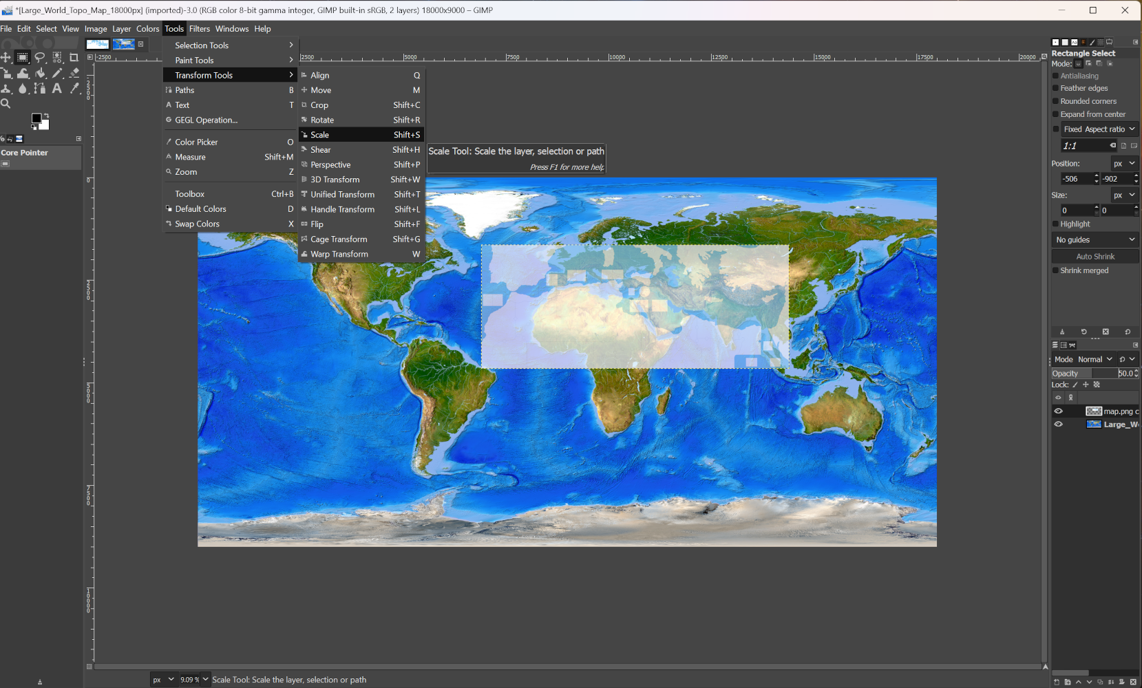
Here is an example of what I meant before about stitching an image into the pattern when using a map relief.
I like to use this one from the wiki, it's a satellite terrain image, so it's not going to match the standard sorts of world map projections like mercator or robinson, or for example the projection used for the WW2 political atlas/maps year by year on the wiki. But that's ok since it's more impressionistic and once the image has it's opacity reduced, a pattern laid on top, and the national hex colors passed through it, some of the details can just go fuzzy.
Anyway, it's a nice large image. Here is the jumbo size from the wiki reduced to 18000px which is about as large as I can work with on my laptop before my GPU starts struggling hehe.
https://drive.google.com/file/d/1paHIOxdoc4gNJM681EqolrQDAlfA71e9/view?usp=sharing
Doesn't need to be that large, since only focusing on Europe. There are probably other similar sat maps or period maps that might work better, but since this one was chilling on the desktop I used it for quick example.
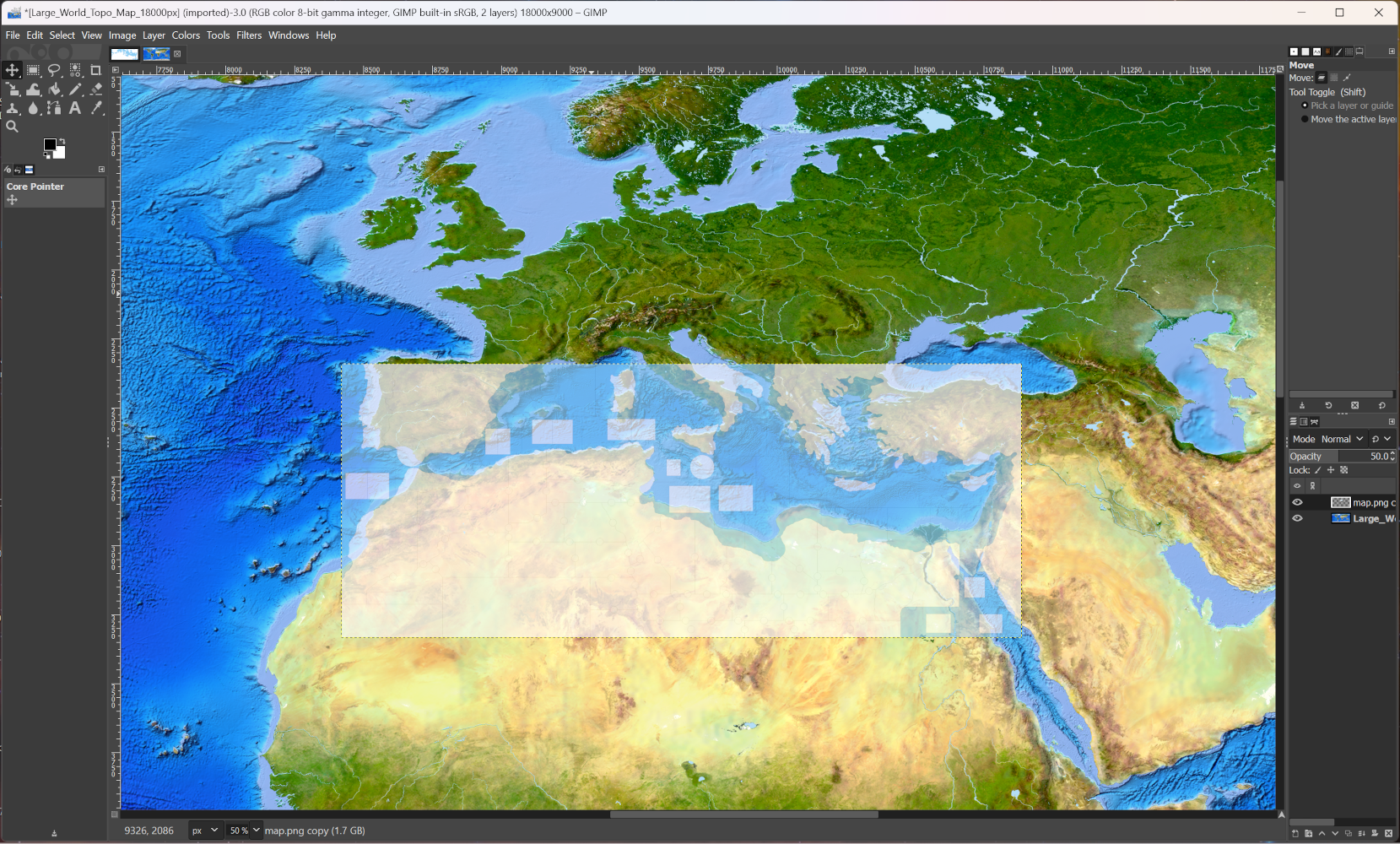
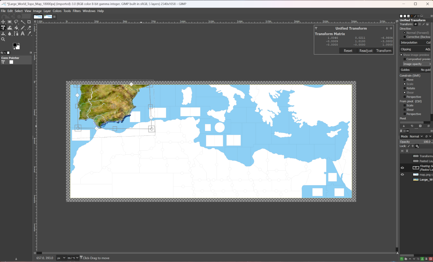
By taking a detail from the big map, and matching the scales up so they're ballpark, you can then use the transform tool to reshape the topo in sections. I like unified transform, since you can scale and twist that one using the anchor points, but any of the transform tools would work.
After you have the area you want selected, you can use the fuzzy select magic wand tool to "paste into a selection" This will prevent it pasting outside the spots you want.
I like to have just a couple working layers at a time so you can raise/lower them, or turn the little eyeballs on/off. Basically you slide the opacity to say 50% for whatever top layer that you're working on, in part so you can see what's happening while modifying it, then later you can adjust the opacity to whatever looks nice, and then merge em all back together as a single layer that is semi transparent to serve as the relief.
You may have to stretch and pull the sections in different parts of the map till you get a coastline that looks ok. Like here I just added in Spain very roughly. It's probably expedient to reshape and morph Italy or Africa or Yugoslavia separately so it's easier to morph using the little anchor nodes. Alternatively you can redraw the base to match the projection of a terrain image you want to use, but that involves changing other things like the place coordinates. Sometimes the boards have distortions for play purposes too, so it can be hard to match that way. I think it's easier to sorta bend reality till it approximates what you want to see drawn in game with the artistic liberties there.
Anyhow a process like this in GIMP
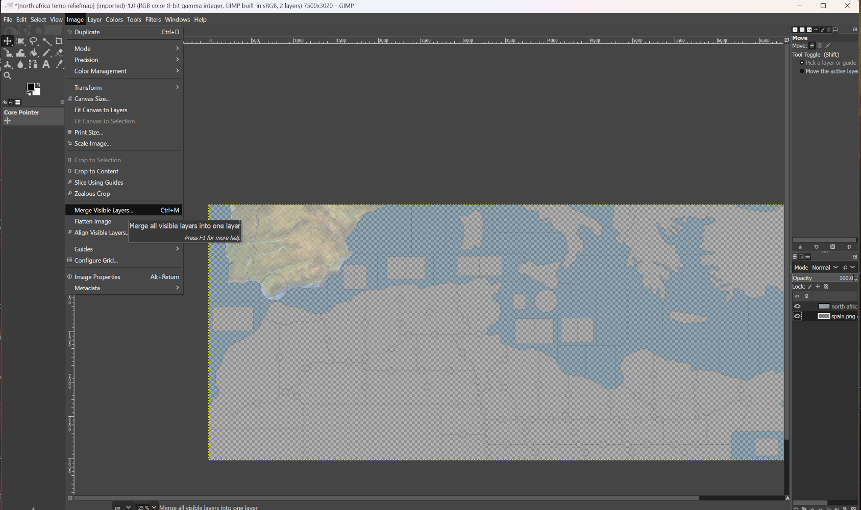
When I get some time to put something together I can do a quick xcf save for you guys, like with the layers up so you can check out how it works. Kinda easier to see that way as opposed to screens step by step, but it's not too hard once you get the hang of it. Can add other things that way as well like patterns for rail lines or desert motifs and such, or extra embelishments. It's hard to see sometimes till it launches inside tripleA with the full colors painted on top, but then it's also easy to kinda change the hex colors later to punch stuff up or knock it back in parts. Once the nuts and bolts are in place it's easier to go to town, but if stuff is changing on the base easier sometimes to just do a simple pattern till everything is sorted and then add on top once it's basically dialed in the base.
-
Have an idea about landmines. The mine territories should be split between the adjoining territories. If you control the territory, either by ownership or the presents of units, you control the mine territories that belong to that territory. 1 mine can then be placed in the territory, then during combat movement they can be given one movement to be moved to the mine territory. Mines already in a mine territory cannot be moved. Movement into a mine territory cost 0 points except for mines. So, movement would be through your mine territory to the next territory's mine territory then into the new territory, but at a cost of 1 movement point.
Thoughts.
Cheers...
P.S. If the map is redone, the missing line between Yugoslavia and Greece can be added.
Cheers...
-
@wc_sumpton said in North Africa - TripleA Module:
If you control the territory, either by ownership or the presents of units, you control the mine territories that belong to that territory.
That is what we are currently using the circles on the map for, or were you suggesting something like having the entire border strip be a territory instead so crossing units must pass the mine?
-
To stop air units from landing on a territory, create a relationship that is allied to both teams:
<attachment name="relationshipTypeAttachment" attachTo="AlliedToAll" javaClass="RelationshipTypeAttachment" type="relationship">
  <option name="archeType" value="allied"/>
  <option name="canMoveLandUnitsOverOwnedLand" value="true"/>
  <option name="canMoveAirUnitsOverOwnedLand" value="true"/>
  <option name="canLandAirUnitsOnOwnedLand" value="false"/> <!-- this will prevent the landing of air units -->
  <option name="alliancesCanChainTogether" value="false"/>
  <option name="isDefaultWarPosition" value="false"/>
  <option name="canTakeOverOwnedTerritory" value="false"/>
  <option name="givesBackOriginalTerritories" value="true"/>
  <option name="canMoveIntoDuringCombatMove" value="true"/>
  <option name="canMoveThroughCanals" value="true"/>
  <option name="rocketsCanFlyOver" value="true"/>
</attachment>
Assign one player the control of all "neutral" territories and then assign this relationship.
Cheers...
-
Would anyone like access to the github for this project? I was working on a good chunk of the XML code up to this point but I have become extremely busy with my IRL job and cannot continue for the time being.
-
-
@wc_sumpton The XML in the github is the most up-to-date, link to download can be found in the first post of this thread.
@DoManMacgee I have the same thing, all those games I'm playing on the forums take all of my free time. Maybe I can take a look at it again this Friday or Sunday.
-
Prof of concept only, this xml is not game ready.
Units in this xml have been capitalized, "infantry" is "Infantry", also they have been normalized, "matilda" is "LightArmor". The unit:
  <unitList>
    <unit name="Infantry"/>
    <unit name="FrenchInfantry"/>
    <unit name="Artillery"/>
    <unit name="AntiTankGun"/>
    <unit name="AntiAircraftArtillery"/>
    <unit name="Halftrack"/>
    <unit name="Scoutcar"/>
    <unit name="LightArmor"/> <!-- Represents British/Italian/French Armor -->
    <unit name="Armor"/> <!-- Represents American/British Sherman/German Armor -->
    <unit name="HeavyArmor"/> <!-- Represents German Tiger Armor -->
    <unit name="Truck"/>
    <unit name="Fighter"/>
    <unit name="Bomber"/>
    <unit name="Battleship"/>
    <unit name="Destroyer"/>
    <unit name="Submarine"/>
    <unit name="Harbor"/>
    <unit name="Supply"/>
    <unit name="5Supply"/>
    <unit name="Landmine"/>
    <unit name="Seamine"/>
    <unit name="ControlMarker"/> <!-- Not used as of now -->
    <unit name="Convoy"/> <!-- Not used as of now -->
    <unit name="AdvanceConvoy"/> <!-- Not used as of now -->
  </unitList>
There are no required capitals, they are created/removed to put the game board in a location for gameplay. British player starts in the lower right corner, to place units in these three territories. Supplies can be bought in 5-unit stacks, but once placed will convert back to single units.
There is only a single purchase for each player but there are two placement phases so unplaced units will survive, even between turns.
All movement is conducted through mine zones, which should cost zero movement.
Again, use with caution.
Cheers...
-
This North Africa module has been upgraded considerably. Would you like to check it out? Maybe you have some ideas to improve it even more
To download it, click on the github link in the first post of this threadBy the way, on a different note, I did notice your further improvements to my D-Day module, although I haven't had the time to take a deep look at it or even react to it. No worries, I will do that later this week!
-
@victoryfirst There is no github link in the first post.
Hello! It looks like you're interested in this conversation, but you don't have an account yet.
Getting fed up of having to scroll through the same posts each visit? When you register for an account, you'll always come back to exactly where you were before, and choose to be notified of new replies (either via email, or push notification). You'll also be able to save bookmarks and upvote posts to show your appreciation to other community members.
With your input, this post could be even better 💗
Register Login