Ancient Empires: 222 BC
-
@Hepps No, it would be just a normal border. Then if at some point attack penalties over rivers are possible, I'll add those.
I wander if I should further extend rivers into terriotiries, or only use those (or their parts) that are useful as borders. In the example above the real river should probably extend a bit into the Sparta region.
-
@Name The image looks great BTW... a dramatic improvement.
It is really hard to say if or how that feature would be implemented. I would lean towards removing the rivers from the base map image and simply add them to your relief layer.
-
Talking about rivers, are the Dardanelles and Bosporus straits going to be treated as rivers, that now would mean simply being a connection?
-
@Hepps Thanks, I had good advice:)
Any good reason they shouldn't be on the core map? I think it won't be hard to understand that rivers are just decorative/normal borders. And then if at some point I can improve their function, they will be ready in place.
@Cernel I'm thinking to just treat the Propontis (Marmara) Sea as every other sea territory. So you would need ships to cross.
-
@Name said in Ancient Empires: 222 BC:
@Hepps Thanks, I had good advice:)
Not often I hear that.
 Thankfully it is in writing... so I have evidence for my wife!
Any good reason they shouldn't be on the core map? I think it won't be hard to understand that rivers are just decorative/normal borders. And then if at some point I can improve their function, they will be ready in place.
I guess it really doesn't matter as you can just ignore these "Territories" while doing the map making process. In fact it is likely better that you leave them... because if you need a territory for the river if/when this were implemented... they are already there. If you do not they can be left ignored.
-
@Hepps said in Ancient Empires: 222 BC:
I guess it really doesn't matter as you can just ignore these "Territories" while doing the map making process. In fact it is likely better that you leave them... because if you need a territory for the river if/when this were implemented... they are already there. If you do not they can be left ignored.
I did not completely understand this.
Btw I thought of a rather complicated system related to territory effects and combat, that might be possible add. Credits to @Cernel for inspiration through an older post.
Say we have regions with a "mixed" terrain and various leader units.
Then depending on some attribute of a defending (?) leader unit there would be a chance to choose among various terrain types, some favoring defending units. Then change the territority effect to that, until battle is over, then revert it. Or if we could compare attributes between attacking, defending (and no) leaders to determine chances, it might be even more interesting.I probably won't add something like that, at least not for a long while (and not sure it's even possible), mostly throwing the idea for general brainstorming.
-
@Name said in Ancient Empires: 222 BC:
@Hepps said in Ancient Empires: 222 BC:
I guess it really doesn't matter as you can just ignore these "Territories" while doing the map making process. In fact it is likely better that you leave them... because if you need a territory for the river if/when this were implemented... they are already there. If you do not they can be left ignored.
I did not completely understand this.
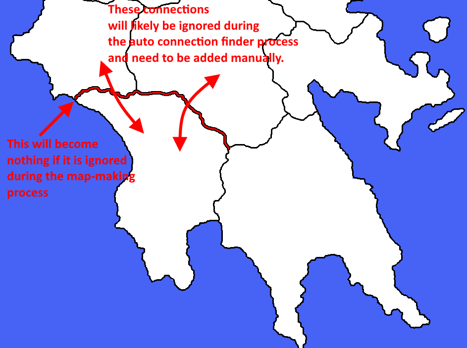
So with it drawn as is... you would be able to click on this in the map making process and actually make it a territory. If you simply ignore it then it will become nothing when you are playing. Hovering over it while playing will yield nothing. But you may have to manually add the connections between the adjoining territories as the auto connection finder will likely not recognize all three of the territories are meant to connect.
Btw I thought of a rather complicated system related to territory effects and combat, that might be possible add. Credits to @Cernel for inspiration through an older post.
Say we have regions with a "mixed" terrain and various leader units.
Then depending on some attribute of a defending (?) leader unit there would be a chance to choose among various terrain types, some favoring defending units. Then change the territority effect to that, until battle is over, then revert it. Or if we could compare attributes between attacking, defending (and no) leaders to determine chances, it might be even more interesting.I probably won't add something like that, at least not for a long while (and not sure it's even possible), mostly throwing the idea for general brainstorming.
Interesting, I will have to ponder this.
-
@Name Here is a visual of what I am trying to explain...

-
@Hepps Auto connection finder? I've been adding those manually in the XML. Does it work for land to sea and sea to sea as well?
More ideas:
- What if the river is assigned a territory, only to consume movement? (I probably won't use that due to visual and other concerns but it might evolve to something interesting). Fast units could cross it at once, slower ones would lose a turn.
- The river could be assigned a territory, only as flavor, displaying the river name on mouse-over.
-
@Name said in Ancient Empires: 222 BC:
@Hepps Auto connection finder? I've been adding those manually in the XML. Does it work for land to sea and sea to sea as well?
Yes the map making program will do all connections automatically. There are just some situations where it misses things... one being what I just detailed.
More ideas:
- What if the river is assigned a territory, only to consume movement? (I probably won't use that due to visual and other concerns but it might evolve to something interesting). Fast units could cross it at once, slower ones would lose a turn.
Yes this is possible. The only issue you face is that visually if units move into a river territory that is only 3 pixels wide... graphically it will become an issue as the units will be visually in a territory they do not fit into. Can be very confusing to a player(s) if units end their turn in a territory that makes them look like they could be in any one of 3 territories.
- The river could be assigned a territory, only as flavor, displaying the river name on mouse-over.
You could make it an actual territory and have it with no connections. Then have the needed connections added manually as described above. Yes.
-
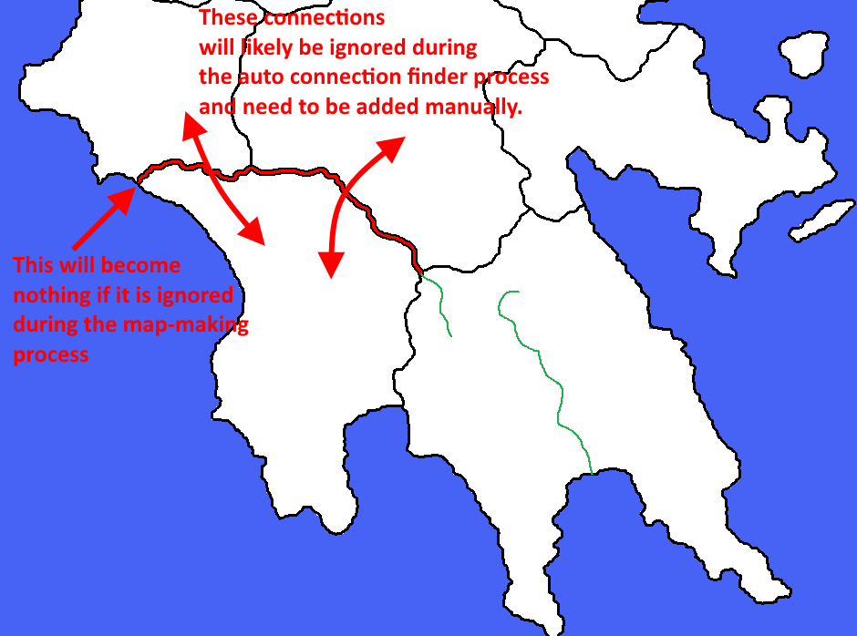
@Hepps / Everyone. What do you think of adding rivers/river parts as marked in green? Should I go for it for extra flavor or just ignore those?

-
@Name Well Hepps probably knows better than I do but my guidance is unless you want the rivers to be an actual territory, its easier to just do them in the relief layer as then you don't have to worry about it creating lots of little fake territories or messing up connection finder. That way you are essentially just drawing them over top of your base map and can visually represent them however you'd like.
If you want the river to actually be territories, then you'd probably need to make them wider to be usable (something like Civil War).
-
@Name The flavor is a sweet thing... just be ready for the work ahead.
 I can tell you from experience that once you start... the journey is long and arduous... especially if you are anywhere near as OCD as me.
 -
What other edge cases besides (thin?) rivers does the connection finder have issues with? Islands/Territories with separated parts?
I like the idea of hovering over rivers to display their names, instead of having it display a wrong territory name or making the rivers too thin to be visible when zoomed out (game will be played at about 50-75% I guess).
I'm an often lazy perfectionist or something along those lines. If I can stay motivated (though I doubt I'll always have the time to work at the current pace) I can take a lot of punishment:p. I hope I'll stick to the task, after modding various games I think this one has the best ratio of desired features and flexibility I've found. Helpful knowledgeable people is a big plus as well:).
-
@Name The biggest issue is playability.
A severely small or thin territory is a nightmare from a gameplay standpoint because...
If you are trying to move into it... hitting it with your cursor can be very tedious and frustrating.
Trying to click on a very small or thin territory inorder to select all units is the same.
This problematic issue is compounded further if you intend your map to be played at a dramatically zoomed out view.
-
@Hepps Yeah that is out of the question already. I just threw around the idea to generate discussion on possibilities of the use of rivers. I'd only use something similar with much thicker river territories.
-
@redrum I think you accidentally edited my post instead of yours.
-
@Name Indeed. Reverted that
 My bad here is my post:
So the way the connection finder works is it searches a certain number of pixels away from a territory for other "adjacent" territories. And then if enough pixels of another territory are found then it considers it adjacent and adds a connection. You can adjust the distance it searches to try to handle different border widths (think your original wider borders vs the thinner ones you have now). But a larger distance means it might find incorrect connections especially around territories that say come together at like 4 corners. You can always manually adjust these or manually do all connections but it is fairly time consuming for a large map.
Territories with multiple parts are group together into a polygon definition: https://github.com/triplea-game/triplea/wiki/Map-and-Map-Skin-Making#413-polygon-grabber
You could use the thin rivers just for naming though it would probably be better to instead just write the names like TWW does in the relief tiles on the map itself as hovering over the 3 pixel river is going to be challenging anyways though you could do both.
-
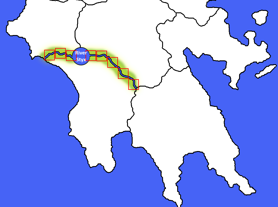
@Name Here is a possible solution...

Add a circle (big enough to be clickable at any zoom)
Manually add the placements to ensure they fall along the river avoiding the circle so that it is easily clicked on.
Add some kind of colouration or detail to the relief layer to clearly indicate which units are in the river territory.
-
@redrum I'll think about it. Both ways have pros and cons and none seems clearly better or bad.
The way you present it made me realise that besides being challenging, hovering over the river won't display adjacent territory names if it is a relief, since that 3 pixel area would be a border on the original map. However now river borders might be in territories, so some black pixels will display territory names while others not. Plus I need to be carefull to exactly match borders and rivers. Quite small issues though. On the other hand not using them as reliefs has the extra connection work.
@Hepps It's interesting in this (show)case but still I don't think I'll use that feature. Some rivers will be too long for it to visibly make sense. Not sure it's a good idea to include a semi-confusing system and having to split the Danube in 20 or 30 territories.