New blank map for mappers
-
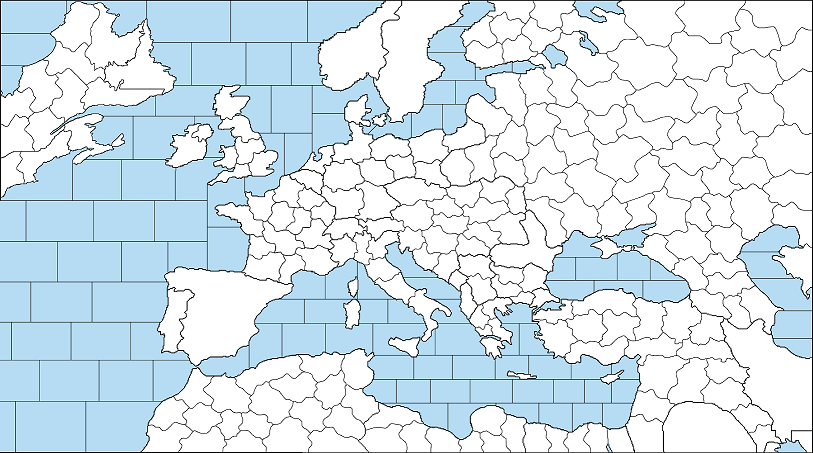
I've made a high resolution WW1 base map, smoothed the borders, removed small islands and lakes. Ready for mappers if they are interested in to define territory borders.
https://i.ibb.co/WGskWjf/National-Borders.png
I'm going to try to define territories to be suitable for both World Wars.
Any suggestion is welcome.
This one is made according to the unified colour scheme.

-
With territories. Still considering to add island factories on the Atlantic to represent the battle of Atlantic and improved USA logistics plus territories for neutrals to make it suitable so many scenarios.
-
@schulz I like this map a lot, it looks like it took a lot of effort to make! Things I notice:
- Country borders are pixelated although inner territory borders are not
- Looks like it will take a long time to cross the Atlantic Ocean (might not depending on movement speed)
- I like the amount of detail, definitely allows for a lot of interesting gameplay!
-
- The country borders were originally pixelated but probably need to draw over them to keep consistency.
- I'am thinking to add small factory islands on the Atlantic to represent the battle of Atlantic and giving the US new productio centers (like in Great War map)
-
Also alternatively the US can just become part of Britain and France when joins the war. So though decision for me.
-
@schulz I don't think you should make the United States part of Britain or France when they join the war. In real life, the British and French tried to absorb the American Expeditionary Forces into their own armies as replacement units, but General of the Armies John J. Pershing insisted that the AEF would remain under his command: https://en.wikipedia.org/wiki/John_J._Pershing.
-
@iratoric While it is true but personally I don't really like having nations with only one front. I'am skeptical if playing with the US can be really fun when its only way to play with it is reinforcing Northern France.
-
@schulz Some ways to make the United States more interesting:
- Make it so they have to defend convoy zones at sea to simulate the U-boat war
- Another front could be the Italian front since some American troops fought Austria-Hungary (not as many as were in France though)
- American troops in Russia (They intervened in the Russian civil war): https://en.m.wikipedia.org/wiki/American_Expeditionary_Force,_Siberia
If you are going ahistorical they could fight the Ottomans in North Africa. The United States broke off diplomatic relations with the Ottomans but stopped short of declaring war. If the British failed to contain the Ottomans, though, I could see the United States declaring war on the Ottoman Empire.
-
-
I would need to allow Germany placing subs in the Middle of Atlantic but German factories in here should be uncapturable. Not sure if it is possible to for factories work on impassable territories. Even U-boats can become separate entity too.
-
Reinforcing the Italian front doesn't really make sense since if the US reinforce Northern France, it will allow France to reinforce N.Italy more insensively.
-
The same for intervening the Russian civil war or reinforcing the Middle East. France is closer than both of them.
-
-
@schulz I think the fact that the United States and Britain cannot be attacked by land will make them able to move their troops wherever they please. On the other hand, if France transported all their troops to Russia or North Africa, it would be a fatal mistake because Germany would quickly invade them.
Just so you know, you can make factories on impassable territories. You will be able to move units out of the territory but not back into the territory.
-
@iratoric I think the best way to bring the US into the war is to give the US control of Bordeaux. This was historically the US logistics depot. There is no need for the US to build lots of transports, as the difficulties of bringing the troops across the Atlantic can be reflected by lower income or higher costs.
-
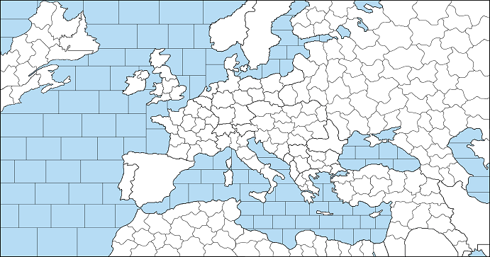
What about making the US closer to Europe like this one?
-
@schulz This is a good solution. If you want to keep the geographically accurate map, then you could just make the sea zones larger so it takes less time to cross the ocean (or make the movement speed higher).
-
@iratoric Even the first map is geographically inaccurate because the US is still closer to Europe than it is in reality.
I see it is still possible to simulate the Battle of Atlantic in the second one plus less waste of sea zones. (I even though to go with World map)
-
Actually 5 sea zones between America/Canada-Europe is better since it is easier to calculate movements.
-
-
The Northernmost Europe is also added.
Hello! It looks like you're interested in this conversation, but you don't have an account yet.
Getting fed up of having to scroll through the same posts each visit? When you register for an account, you'll always come back to exactly where you were before, and choose to be notified of new replies (either via email, or push notification). You'll also be able to save bookmarks and upvote posts to show your appreciation to other community members.
With your input, this post could be even better 💗
Register Login