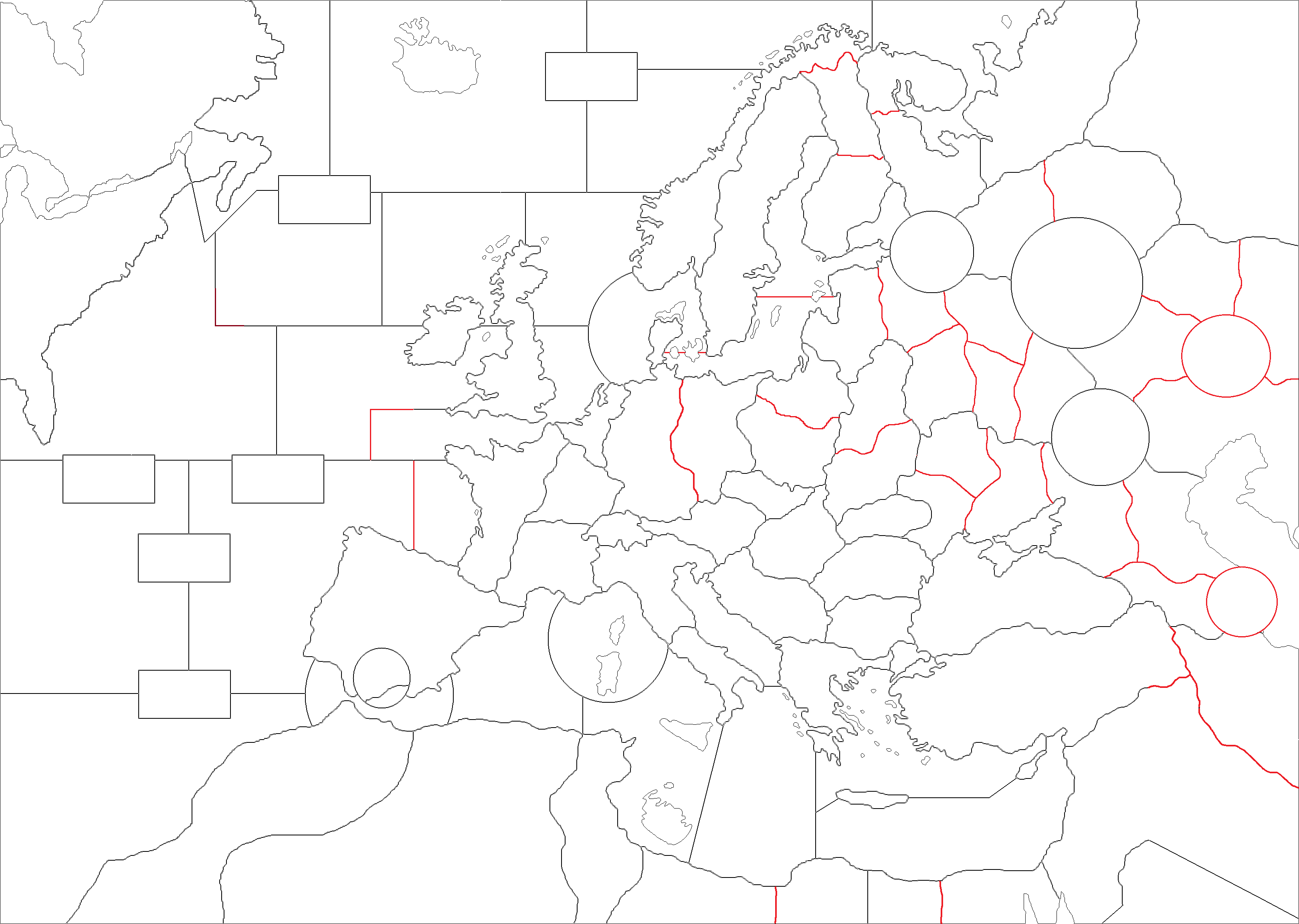
Possible revision on Europe (1999) map
-
@schulz said in Possible revision on Europe (1999) map:
- Really I don't like any kind of boxes.
The box in my design can be deleted: it is there just because that is a virtually useless and difficult portion of the map to represent (everything to the west and north of the Labrador sea): it can be simply substituted with nothing (possibly using the available space for showing a logo or something, like the bottom-left corner of "270BC Wars").
- I think Canada and USA should have the same distance to Europe and N.Africa and 5 distance is easier to calculate things rather than 4 distances.
Are you talking merely from a game-play stand-point? The distance between Boston and Brest is 5077 km (and it is actually farther away if you go by sea), whereas the distance between St. John's (Newfoundland) and Brest is 3531 km.
A thing that certainly strikes me in your design is that Iceland is almost as much far away from Great Britain as the United States of America are (3 and 4 sea zones in between, respectively). Beside islands, Great Britain - Iceland is 817 km, whereas Great Britain - USA is 4318 km!
Also, in your design, Iceland is closer to the United States of America than to Great Britain, while the distances would be, respectively, 3428 km (for 2 sea zones, so about 1714 km per sea zone) and 817 km (for 3 sea zones, so about 272 km per sea zone).The sea zone of the English Channel seems doomed to have some massive overflow lines (being so small).
-
-
Yes, purely for gameplay reason. It is just easier and there isn't really a reason constantly forcing US player to move its troops to Canada. It makes playing with US harder.
-
Good catch. Iceland should be moved to East.
-
-
@schulz said in Possible revision on Europe (1999) map:
- Yes, purely for gameplay reason. It is just easier and there isn't really a reason constantly forcing US player to move its troops to Canada. It makes playing with US harder.
I wonder if they historically did so, moving US American military units by land to Canada to shorten sea travels through the Atlantic ocean, which is a very common move in TripleA games. Logistically, you would not normally do such a thing, since sea travels are much less costly than going by land.
-
@cernel said in Possible revision on Europe (1999) map:
@schulz said in Possible revision on Europe (1999) map:
- Yes, purely for gameplay reason. It is just easier and there isn't really a reason constantly forcing US player to move its troops to Canada. It makes playing with US harder.
I wonder if they historically did so, moving US American military units by land to Canada to shorten sea travels through the Atlantic ocean, which is a very common move in TripleA games. Logistically, you would not normally do such a thing, since sea travels are much less costly than going by land.
A better solution is giving the US a naval base with bonus movement on the East Coast, so there is no reason to go up north.
-
@rogercooper I'm not seeing that making sense: Canada has naval bases too.
Boston - Brest is 5078km (or rather 5099 if you account for the necessity of skirting Nova Scotia and Newfoundland).
Halifax - Brest is 4429km (or rather 4439 if you account for the necessity of skirting Newfoundland).
So there you have a saving of more than 600 km of sea travel.
In theory, you can save more than twice as much if you depart from Newfoundland, but, being Newfoundland an island, it would make hardly any sense to do so, as you would have to ship units there anyway.
St. John's - Brest is 3531km. -
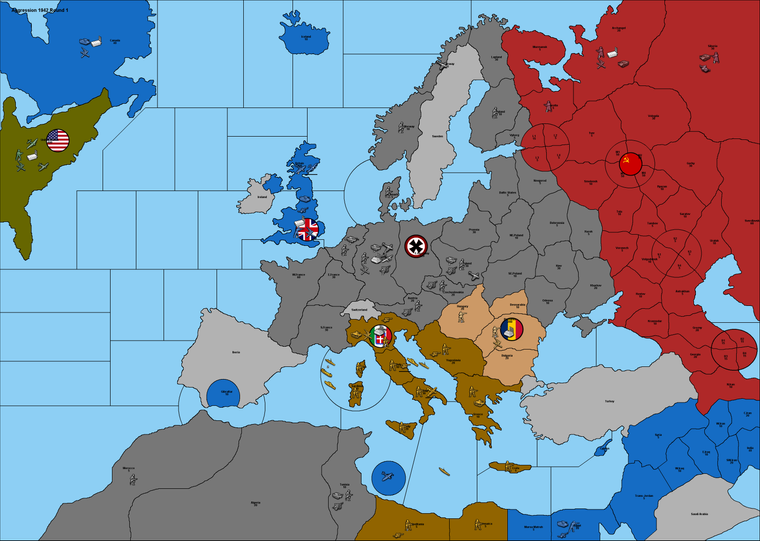
@schulz Also, why did you remove the circle representing Russia's second capital (Kuybyshev)? If anyone, it is Stalingrad that should not be represented as a circle. The only reason I didn't remove it is because I didn't want to go too far away from the picture of the original map.
-
@Cernel Because Russia would already collapse if Germany had captured Archangel-Astrakhan line.
-
Still working...
- Victory is achieved when you capture your first enemy capital.
- V3 units and rules with a few exception. Cruiser cost will be 11 and carrier defense will be 1.
- I am not sure if 50 armour cost is so cheap when infantry is 30.
-
@schulz I think that, if the southernmost circle is representing the city of Baku (so not the whole Azerbaijan), Georgia should be named Transcaucasia (as it would represent both Georgia and Azerbaijan).
-
Here is the first draft;
-
@schulz I dislike the Domination-Shanghai-style cities, especially for a small city like Stalingrad, as it makes no sense having Stalingrad and not Kiev as a city, and, in my opinion, it was sensible in the original map only as long as you would consider that the circles were merely extensive territories just like any other territory.
I'm not seeing how it is a good idea to have a Romania (which, by the way, I believe was called Roumania or Rumania in English, back then, Romania being only the ancient Latin name) power, for a number of reasons.
1- Roumania was a minor ally of Germany, not anything on the same political level: it would make no sense for Roumanian units to be able independently to annex territories their armies conquer.
2- Roumania was integrated and subordinated within the German chain of command, so it should better be able to attack together with the Germans.
3- Having historical Roumania, Hungary and Bulgaria as a single player makes no sense because they were rather united only by their common subordination to Germany. In particular, Hungary and Roumania hated each other so much they couldn't possibly operate together and Bulgaria was hardly an Axis country at all: having been forcefully allied to Germany and never at war with Russia (It's about the same thing as Pakistan being an allied of the United States during the war in Afghanistan.).
4- Odessa and a large part of the Odessa territory was annexed to Roumania, not to Germany, making impossible properly to represent the ownership of the Odessa territory unless Roumania is part of Germany. https://en.wikipedia.org/wiki/Administrative_divisions_of_the_Kingdom_of_Romania_(1941–44) -
@schulz About Yugoslavia, Greece and Crete being part of Italy: they should rather be part of Germany.
Yugoslavia was eventually fully split into an Italian and a German zone, but most of it was under German control, or would-be control, despite the hollow Italian protectorate over Croatia. Though, the Italians did have a big piece of Yugoslavia: something like one-third of it after the failed state of Croatia was split between Germans and Italians too. An alternative would be actually to split the Yugoslavia territory into two (or more) territories.
Greece was mostly under Italian occupation, yet I believe the Germans were getting most of its productive capacity. So, if the production value of Greece should go to a single power, it would make the most sense by far for this power to be Germany (not Italy). Moreover, Greece maintained a single collaborationist government, so the German and Italian zones were actually a single polity factually under mostly German control (I think the Italians made very little money out of Greece, while the Germans made quite a lot).
Crete was still part of Greece, so I think what said for Greece applies to it too and, moreover, most of Crete was actually under German occupation. -
-
Really not much way to represent Battle of Stalingrad which took several months without dividing the city. And it is already the least valauble Soviet circle-city. Kiev is not circle because of aesthetic purpose. Plus the game would be probably end if the Soviets going to fight to take Kiev.
-
If Romania was part of Germany then Germany could use all of Romanian incomes to fight for example in W.Europe or N.Africa which realistically couldn't.
-
Also if there would be no Romania, the game wouldn't be multi-friendly. With that One player can take Germany and the other one can take both Italy and Romania.
-
Yes, Romanian representation is unrealistic but I do believe there should be 3.rd Axis country. I was thinking to add Finland instead Romania-Hungary-Bulgaria but it would be even weaker than Romania and it wouldn't be interesting to play with them.
-
I was thinking giving Odessa to Romania too but Odessa in the game actually represent way bigger area than the Romanian annexed part.
-
Yes, Italian controlled territories are questionable. Just I think it is aesthetically more pleasing to see them as part of Italy and it is not very unrealistic either. Also giving these territories to Germany would make Italy even weaker which I would want to give Italy a good chance to success in North Africa.
-
-
@schulz said in Possible revision on Europe (1999) map:
Here is the first draft;
Sendspace is full of questionable stuff and my security software won't allow a download. Post it with Google files (free account).
-
@schulz I definitely think that what I dislike the most about the drawing (which is overall quite good) are the Shanghai-style cities. Moreover, the capital flag on Moscow makes the connections unclear. In particular, why are "M1" and "M4" connected but not "M2" and "M3"? It is also unclear that "M2" only is the capital.
I don't believe that the Soviet Union economically collapsing with the fall of Moscow is a sensible assumption. I would rather say it rates pretty high amongst the greatest absurdities of the basic TripleA games.
It would be nice to know what month of 1942 the game starts. Regardless, Smolensk has been German for the whole 1942. Hell, even Rzhev (which is 218 km north-east of Smolensk) and Vyazma (which is almost mid-way from Smolensk to Moscow) did.
https://en.wikipedia.org/wiki/Operation_Büffel -
-
Dividing the cities is probably the easiest solution to represent urban warfare. It shouldn't be too easy and quick to take these cities.
-
I agree the Soviets probably wouldn't collapse if Moscow has fallen but relocating the Soviet capital to the east would just delay the the collapse of the Soviet Union in TripleA games because of huge production swings. It is also aesthetically more pleasing to see the Soviet flag on Moscow. I would prefer keeping the victory condition simple as much as possible.
-
M1 and M4 shouldn't have connected, I will fix that.
-
Yes Smolensk should be replaced with Mozhaisk. It would be nice to represent Rzhev salient too but unfortunately there is not much space left. The same as Murmansk.
-
-
-
@schulz said in Possible revision on Europe (1999) map:
- Yes Smolensk should be replaced with Mozhaisk. It would be nice to represent Rzhev salient too but unfortunately there is not much space left. The same as Murmansk.
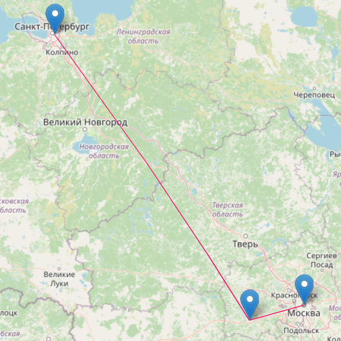
I agree Smolensk as a name doesn't make much sense with the drawing, but I'm not seeing how calling the current Smolensk territory as Mozhaisk would make any good sense with the drawing or would even be any better than Smolensk. The territory as drawn is in between of Leningrad and Moscow, and it is one of the two shortest ways from Leningrad to Moscow. Mozhaisk (which, by the way, is a very small city) is almost a suburd of Moscow, located 103 km west-south-west of Moscow and most certainly not in between of Moscow and Leningrad: the distance from Moscow to Leningrad is 630 km, the distance from Mozhaisk to Leningrad is 594 km and going from Moscow to Leningrad through Mozhaisk is 698 km!
This is what it looks like going from Moscow to Leningrad through Mozhaisk:
-
@cernel What about Rzhev or Kalinin?
-
@schulz said in Possible revision on Europe (1999) map:
@cernel What about Rzhev or Kalinin?
Kalinin was the name of Tver at the time (so it should be Kalinin in my proposed mapping too) and, as I said, Rzhev has been German from October 1941 to March 1943. Rzhev itself is maybe a decent name and would represent the western (German occupied) half of the Kalinin oblast, but it would be likely better just to have only one territory (Kalinin) in between of Leningrad and Moscow, for example by moving the border between Novgorod and Smolensk eastward enough.
It always strucks me how unconstrained the Soviet Communists were in changing names to cities. Tver is a city with a very old and important history (certainly more important of someone like Kalinin): it seems unthinkable to change its name.
Hello! It looks like you're interested in this conversation, but you don't have an account yet.
Getting fed up of having to scroll through the same posts each visit? When you register for an account, you'll always come back to exactly where you were before, and choose to be notified of new replies (either via email, or push notification). You'll also be able to save bookmarks and upvote posts to show your appreciation to other community members.
With your input, this post could be even better 💗
Register Login