Realistic WWII Scenario
-
@schulz said in Realistic WWII Scenario:
- Really I have never seen any TripleA map that UK can reinforce Egypt via Britain.
That is because no TripleA map is a realistic WWII scenario (which is the name of this topic).
-
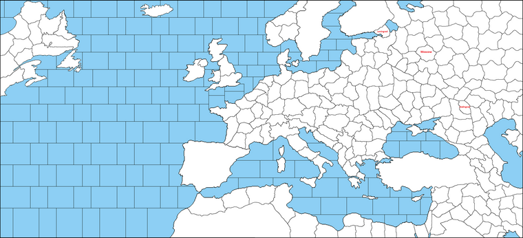
Berlin - Leningrad 6
Berlin - Moscow 7
Berlin - Stalingrad 10Moscow - Leningrad 3
Moscow - Stalingrad 4The only issue for me is it feels like Moscow is in too much north. But it is not much easy to move it to the south while keeping the same distances and keeping all territory sizes relatively similar. I've tried to reflect both of the situations (30 October-5 December) but didn't really work.
-
@schulz said in Realistic WWII Scenario:
Berlin - Leningrad 6
Berlin - Moscow 7
Berlin - Stalingrad 10Moscow - Leningrad 3
Moscow - Stalingrad 4The only issue for me is it feels like Moscow is in too much north. But it is not much easy to move it to the south while keeping the same distances and keeping all territory sizes relatively similar. I've tried to reflect both of the situations (30 October-5 December) but didn't really work.
Moscow can be there, albeit barely, but you should rather redraw the Rzhev salient. You are showing Moscow north of Rzhev, while Moscow is south of Rzhev: extend that salient northwards.
Are you using the Mercator? The problem with Mercator is that it massively increases areas going north. That is why I gave you an equal-area projection. Any map made using Mercator as reference will have either Moscow closer to Stalingrad than to Leningrad or, if you try to keep real distances, northern territories hugely bigger than the southern ones (which will look bad and it is substantially a waste of space in the north or too little space in the south or both).
-
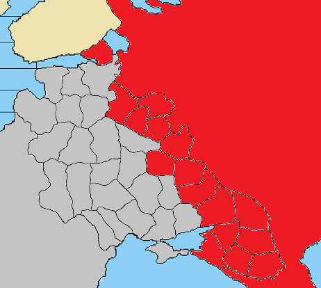
Here is the original map which is probably a mix of Mercator and Smyth Equal Surface
I think both Smyth Equal Surface and Mercator has its downsides. Mercator just look really ugly when going too north thats one of the reason why I didn't include the extreme north.
Smyth Equal surface OTOH is more realistic but the problem is it feels like a squeezed earth which isn't really pleasing to see.
-
@schulz That is some pseudocylindrical projection, like the Ecker IV, actually, which is not a problem since you don't need it to wrap horizontally.
https://en.wikipedia.org/wiki/List_of_map_projections#/media/File:Ecker_IV_projection_SW.jpg
However, I don't understand why you went for a pseudocylindrical since, with your cut, that is going to be barely noticeable, so you miss having straight meridians (making it harder for you to position everything vertically) to hardly any benefit in exchange. -
@cernel You are right, its better to work over a map with straight meridians (like Mercator), I didn't care much about it really since it is not a world map. But If I would turn it into World map then I would use Mercator but cutting the extreme north.
-
@schulz said in Realistic WWII Scenario:
Smyth Equal surface OTOH is more realistic but the problem is it feels like a squeezed earth which isn't really pleasing to see.
Really, since you are using so little of the globe, that should be next to no issue for you as long as you pick a standard parallel that is about in the centre of your map. For example, a version you may like is the Balthasart projection. But, as I said, you can really have whatever standard parallel you want by simply shriking the image of any cylindrical equal-area with any graphic program.
https://map-projections.net/single-view/balthasart
The Mercator is a very bad choice for a map depicting most of the globe unless you want to have increasingly bigger areas as you go north so to split them into more and more zones representing smaller and smaller portions of the real world. Otherwise, you'll end up with something like having a very small "Italy" and a very big "Finland" like in "Big World", in which you have too little space in "Italy" and "Greece" and way too much space in "Finland" and "Norway" - also ridiculously enourmous Greenland and Baffin Island.
-
@schulz said in Realistic WWII Scenario:
@cernel You are right, its better to work over a map with straight meridians (like Mercator), I didn't care much about it really since it is not a world map. But If I would turn it into World map then I would use Mercator but cutting the extreme north.
I believe the one closest to what you are using but with straight vertical meridians is the equirectangular projection.
https://en.wikipedia.org/wiki/Equirectangular_projection#/media/File:Equirectangular_projection_SW.jpg
The eqirectangular is substantially something in between of an equal-area and a Mercator. -
@cernel Balthasart and eqirectangular are both great I could even use one of it as base map if I had known but unfrortunately the drawing is almost finished.
Mercator is actually great since it enlarges Europe and provide more space but if a mapmaker will use it, they should totally cut anything above Leningrad. Anyway I could see the only possibility to represent Pacific is just basically having two separate fronts considering the current size.
-
@schulz I really like equirectangular. The directions are true, which is more important for game purposes than equal area.
Check out this XKCD cartoon What Your Favorite Map Projection Says About You
-
@rogercooper Me too. I do believe a map should look aesthetically pleasing to see which Mercator really provides it (minus anything over Leningrad). Plus it enlarge Europe.
Another problem with a realistic map would be wasting %80 of territories due to lack of actions. Like most of Oceans, inland of America/Asia and Sub Sahara etc...)
-
@rogercooper said in Realistic WWII Scenario:
@schulz I really like equirectangular. The directions are true, which is more important for game purposes than equal area.
Check out this XKCD cartoon What Your Favorite Map Projection Says About You
Equirectangular is good if (like in this case) you want to depict a relatively small portion of the globle (like only mostly Europe). However, if you want to depict a large parte of the globe, that projection is still too distortive (about in the same way as Mercator albeit much less than that): you should always use equal-area projections for that.
@Schulz That is just in case the distortions Mercator gives happen to be what you want. But do you really want to over-size Australia, Siberia and Alaska with respect to Insulindia? Moreover, as I said, good luck having Moscow closer to Leningrad than to Stalingrad while using Mercator.
-
@cernel I don't want oversize Siberia or Alaska that's why I said I am fine with Mercator only if anything over Leningrad is cut.
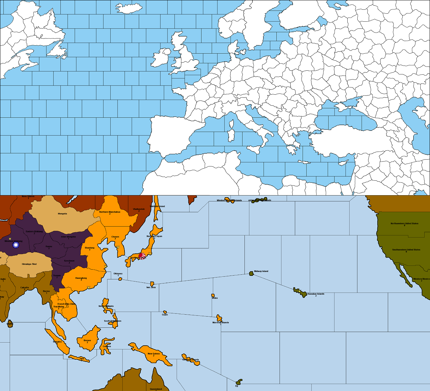
Equal-Area projection imho isn't good either for a world map project because you will end up with abundance of territories that will see no action like Sub Sahara Africa, Inner America/Asia Oceans etc... I am just thinkink that a realistic game should either cover only European fronts or it should have two separate maps inside the same game to avoid having too many unneeded territories like this one;
-
@schulz Equal-area projections distort direction which for this purpose is worse than distorting areas. The distance distortion near the poles can be compensated for by using wider areas.
With a zoomable computer map (as opposed to boardgame) the empty parts of the world are less of a problem. It would be interesting to see if such map is good for play. There are lots of scenarios with distorted maps.
-
@rogercooper I would like to create a world map with the most realistic frontlines and least distortions as much as possible but there are problems:
-
My current map is already 5000 pixel wide turning it into World Map without distortions would make it probably 50000 pixel wide which would make it almost impossible to work over it. Plus incorporating tons of new territiories and adding Japan-China would exceed XML hence slow down games especially on online.
-
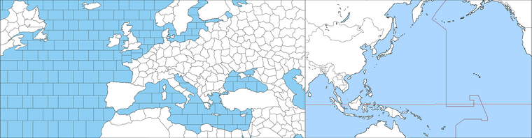
I don't think it is easy to depict the Pacific front realistically. There would be not much reason for US to invest in here when the distances even greater than Atlantic plus lack of valuable targets unlike Northwestern Europe.
-
Japan will also have not much options other than rushing India. It is also problematic to set Japanese-Russian situation.
-
-
@schulz said in Realistic WWII Scenario:
- My current map is already 5000 pixel wide
Make it 10,000: a good number of placement spots for 100% sized unit images and a decent visual for most 4k monitors.
-
@cernel I will use 48x48 images with 100% zoom rate. I think doubling the zoom rate would be unthinkable. How could anyone play missing to see air units and their possible travel routes.
-
@schulz said in Realistic WWII Scenario:
@cernel I will use 48x48 images with 100% zoom rate.
With your drawing at 5,000 pixels wide, I guess more than half of the territories will have less than 6 spots to display the units, which may be unsufficient at times (requiring units to over-flow): I'm not seeing the space you have being enough, with your drawing, if you go with a 5,000 pixels wide map and 48 per 48 units unless you intend to have very few unit types.
However, I would agree that the map doesn't need ot be enlarged as much as doubling both axis (quadrupling the area). I guess that a 8,000 pixel wideness should be already more than enough.
Since you are detailing so much, you may consider splitting the Novgorod territory in two so that you can connect to Leningrad without having to have Novgorod.
Also, Rhodos.
@RogerCooper Would this be the first and only map in TripleA in which Leningrad is correctly drawn, as a matter of its connections? I cannot remember another one: them all get Leningrad wrong for the times of the siege.
-
@cernel doubling the zoom rate would automatically force people zoom out significantly hence ending up with more placement spots but with way smaller units. I would try keeping unit roster small as much as possible to avoid lack of placement issue on the Eastern front.
I think the current Novgorod is fine to represent siege of Leningrad, the Soviets did establish a land connection through multiple times without taking all Novgorod but they were temporarily advancements.
I am undecided about adding Rhodes along with Sevastopol, Oranienbaum Bridgehead, Malta and Gibraltar.
-
@schulz Oh wow! I didn't even notice the absence of Malta. I cannot imagine you may even think about not having it for a map of this scope.
Sevastopol, really, would be better represented by allowing contested territories (something like that happened in other places, like Brest and Odessa). It happens that one side controls most of a territory but the other side "holes up" in a small section of that territory, sometimes holding up for a long time. An historical example is Constantinople for many decades before 1453.
Hello! It looks like you're interested in this conversation, but you don't have an account yet.
Getting fed up of having to scroll through the same posts each visit? When you register for an account, you'll always come back to exactly where you were before, and choose to be notified of new replies (either via email, or push notification). You'll also be able to save bookmarks and upvote posts to show your appreciation to other community members.
With your input, this post could be even better 💗
Register Login