Ancient Empires: 222 BC
-
@Name If you have it as Carthage, that means you are going with English names, thus also Rome, and so on. However, I advise you not using English names if they derive not from the original one (for example, not using Naples if that derives from the medieval name Napoli, not from the classic name Neapolis).
For the high sea, you can have a bunch of canals making possible going into and out those sea zones only during non combat move, then adding a neutral combat units in them, and having your sea units able to move through it but not ending non combat movement with it.
-
@Name The biggest thing to think about is size and how much movement the various naval units will have. As an example, 270BC has fairly large sea zones but pretty cheap ships that have only 1 movement. Most maps have more average sea zones and most ships have 2 movement. So depends how you envision naval and amphibious gameplay.
-
@Cernel I wouldn't use Naples or Napoli in that case. What you see for now doesn't mean I've totally settled, but will probably go for english.
For the high sea that sounds too much imo.
@redrum My ships are fast at 3 or 4 movement. Again, makes sense with the fast, fragile galleys of the era. Since there are generally higher defense than attack stats, terrain bonuses and static defenses, there is a quite strong defenders advantage. So mixing realism with gameplay, I think it's a good idea to have fleets as a means to strike rather distant, less defended territories.
-
@Name By the way, since it is practically the same of what you are already doing, if you want to review all 270BC names, making a full list of all those that are wrongly named or wrongly placed (Siwa…), and post it in the 270BC thread, that would be helpful, in case at any point someone might fix that map too (the issue is that, names being images, one would need to remake all the work, unless @Hepps remembers and can tell exactly all steps to follow to recreate the naming images with different letter combinations, so to do it only for the new ones).
-
@Cernel I can I guess, maybe the right time will be while I'll be reviewing/settling on the final region names.
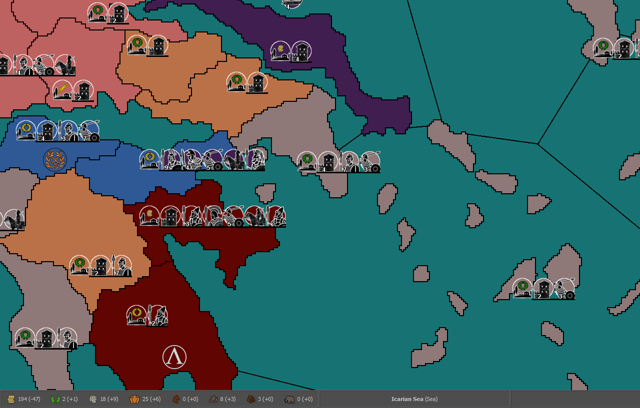
Egypt
-
@Name said in Ancient Empires: 222 BC:
@Cernel I wouldn't use Naples or Napoli in that case. What you see for now doesn't mean I've totally settled, but will probably go for english.
For the high sea that sounds too much imo.
@redrum My ships are fast at 3 or 4 movement. Again, makes sense with the fast, fragile galleys of the era. Since there are generally higher defense than attack stats, terrain bonuses and static defenses, there is a quite strong defenders advantage. So mixing realism with gameplay, I think it's a good idea to have fleets as a means to strike rather distant, less defended territories.
I'm having a hard time envisioning how you could pull this off without it feeling really restrictive. I get what you are going for but it feels kinda excessively limiting on a map of this grand scale. I'd almost rather see you have 2 types of SZ... Coastal and Open Water... where if your fleet(s) ends its turn in an open water sea zone there is something like a 1/12 chance that each unit could be lost to Poseidon's wrath.
")
-
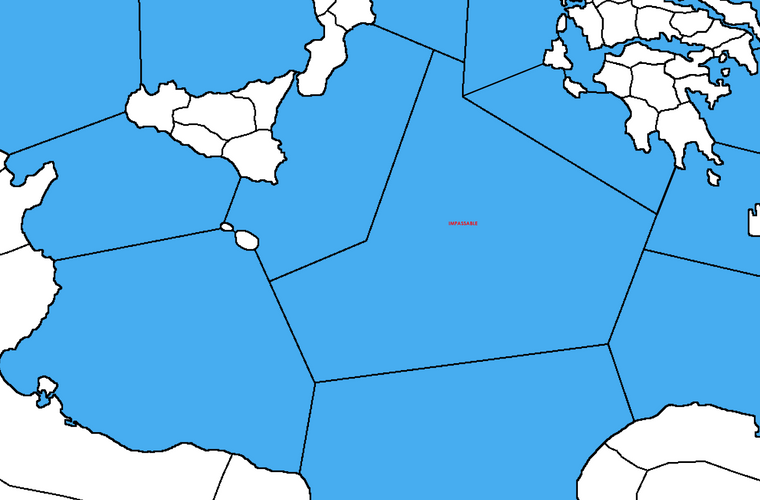
@Hepps Imagine something like this (from a previous version of the map). You can sail around the marked sea zone following the coastal seas. The chance for storms, even for coastal regions, has crossed my mind, but I'll skip it or leave it for later.
@Cernel I checked 270BC a bit. Many of the corrections would need redrawed borders to make sense, while others using the name of some obscure/low populated region.
-
@Name Yeah, I think you could do something like that though I would probably also color the impassible sea zones darker or grayer so its easier to see on first look.
-
@redrum I thought of marking them with a special icon, but this could also work.
-
@Name Also I'm assuming the sea zones will be smaller in your current version? Otherwise 3-4 movement would be able to sail across a very significant portion of the Med in a single turn with your example map.
-
@redrum I guess the above region would contain almost double sea zones. I was thinking of representing each turn as a month, which would be more than enough to sail from Athens to Sicily, but I think I'll have to tone it down for gameplay.
Another similar concern is with combat turn limit. I'll like to reduce it to like 2 per turn, to allow lengthy "sieges" and reinforcements, but during my tests it caused frequent territory ownership bugs (existing even without the change but rather rare).
-
@redrum said in Ancient Empires: 222 BC:
@Name Also I'm assuming the sea zones will be smaller in your current version? Otherwise 3-4 movement would be able to sail across a very significant portion of the Med in a single turn with your example map.
That would be realistic. You can do half the Mediterranean in a couple months, while, in the same time, you can conquer only a few hundreds kilometres into an enemy territory, if you are very successful.
Though, in this case, he would need having much higher movement for land units, and likely a faster non combat than combat movement, so to keep their ability to move through friendly territory in line with the ability of ships to move on sea.
-
@Name Yeah, I think you'll have to be careful around gameplay as if ships can invade potentially 10+ territories that makes whoever has naval superiority very strong though you could also make amphibious very weak. Also being able to move a large army from say athens to sicily to defend makes it so you can have way less land troops potentially defend a very large area.
Yeah there are still some bugs around limited combat turns but I'm very open to fixing these if you find any since we are planning to do this for PoP anyways.
-
@Name said in Ancient Empires: 222 BC:
@Cernel I checked 270BC a bit. Many of the corrections would need redrawed borders to make sense, while others using the name of some obscure/low populated region.
Since all are supposed to be city names, what I suggested was just making a list of all territories for which the name given is:
- misspelled or
- post-ancient or
- not possibly anywhere within the drawn borders.
I supposed that was not a big deal for you, as you are already searching for at least all 270BC names and much more, but up to you.
-
@Cernel said in Ancient Empires: 222 BC:
@Name said in Ancient Empires: 222 BC:
@Cernel I checked 270BC a bit. Many of the corrections would need redrawed borders to make sense, while others using the name of some obscure/low populated region.
Since all are supposed to be city names, what I suggested was just making a list of all territories for which the name given is:
- misspelled or
- post-ancient or
- not possibly anywhere within the drawn borders.
I supposed that was not a big deal for you, as you are already searching for at least all 270BC names and much more, but up to you.
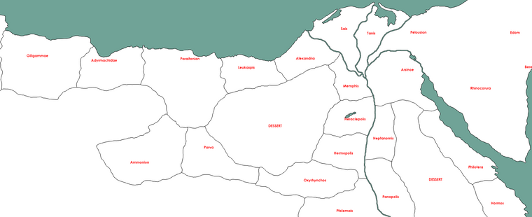
For example, looking at your Egypt naming, assuming all those are correct, then the 270BC names in the same area would be:
- Paraetonium: acceptable
- Alexandria: acceptable
- Hermopolis: acceptable
- Memphis: wrongly placed
Of course, I didn't mean to write down all of this, just the wrong ones (in this case, only Memphis), not listing all the acceptable ones.
Again, just a suggestion, and maybe a way for you to double check.
-
@Cernel Actually, also Memphis might be acceptable, after all.
-
Does this have anything to do with the map being developed?
-
@Hepps "Anything", certainly, as far as naming goes. Going from the I to the II Punic Wars the names should be the same in most cases, beside different languages, mainly either English or Roman or Greek.
-
@Cernel I think it would be better to move any discussion around naming recommendations for 270bc to that map thread as while you could potentially take advantage of naming used in this map if its more accurate, I don't think its relevant to this map's development or that @Name is going to update 270bc.
-
Ok let's keep this on topic and I'll pm @Cernel on the 270BC things.
@Cernel said in Ancient Empires: 222 BC:
Though, in this case, he would need having much higher movement for land units, and likely a faster non combat than combat movement, so to keep their ability to move through friendly territory in line with the ability of ships to move on sea.
I consider generally increasing movement speeds but not sure yet. Say infantry from 1 to 2. Without blitz it will have a similar effect to that, ships have to be at least a bit faster though.
@redrum said in Ancient Empires: 222 BC:
Yeah, I think you'll have to be careful around gameplay as if ships can invade potentially 10+ territories that makes whoever has naval superiority very strong though you could also make amphibious very weak. Also being able to move a large army from say athens to sicily to defend makes it so you can have way less land troops potentially defend a very large area.
The way I envision it (and from tests so far), doing something like that will leave other territories relatively undefended, since you won't have too many units in total. I also think that naval superiority ought to be a large advantage in this era, when contesting coastal regions.
@redrum said in Ancient Empires: 222 BC:
Yeah there are still some bugs around limited combat turns but I'm very open to fixing these if you find any since we are planning to do this for PoP anyways.
Ok I'll report any I find when I'm at that stage again.
Hello! It looks like you're interested in this conversation, but you don't have an account yet.
Getting fed up of having to scroll through the same posts each visit? When you register for an account, you'll always come back to exactly where you were before, and choose to be notified of new replies (either via email, or push notification). You'll also be able to save bookmarks and upvote posts to show your appreciation to other community members.
With your input, this post could be even better 💗
Register Login