Realistic WWII Scenario
-
I have been trying to draw borders on Europe to represent all historical battles as much as possible while keeping all territory sizes very similar. This time (the first time) I would want to make a scenario realistic as much as possible without making the scenario overcomplex.
Some realistic things that I will probably implement.
-
USA won't be close to Europe, it takes really time for them to impact the outcome of the war.
-
Inıtial set up will be totally historical. Starting date will be either December 1941 or Jun 1942.
-
Game will be unbalanced in favour of Allies (as historically) but Germany won't be doomed to fall just their chance will be low (probably like (20%-30%).
-
Finland will be impassable.
-
(Maybe) Limiting stacks per territory and very expensive/ destroyable factories to represent logistic.
-
Upkeep
-
Very expensive transports and cheaper subs so naval invasion will be a lot harder.
-
Historical borders and territory values as much as possible.
The Current Eastern Front for December Scenario:
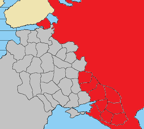
March 1942;
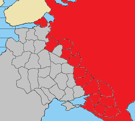
September 1942
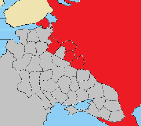
Jun 1943;
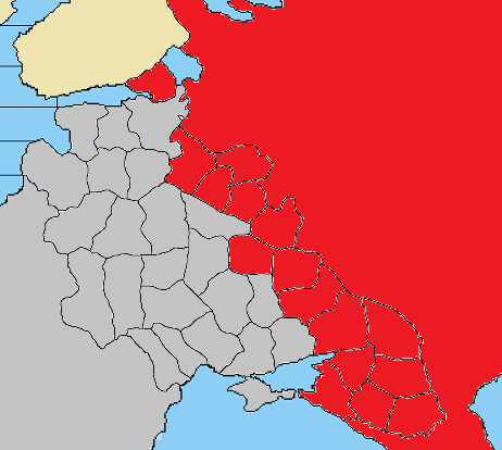
-
-
@schulz said in Realistic WWII Scenario:
I have been trying to draw borders on Europe to represent all historical battles as much as possible while keeping all territory sizes very similar.
If you want to keep territory sizes very similar both in reality and in the drawing, you ought to go with an equal-area kind of mapping. The following projection of the world is "Smyth Equal-Surface" (cylindrical equal-area with standard parallel equal to 37.07143502), centred on 85.521 longitude (so the map border is on -94.479 longitude: the southernmost shore of the gulf of Mexico).
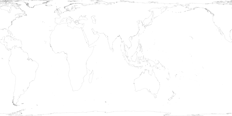
Unfortunately, this forum didn't accept a size of 10,000 per 5,000 pixels, so I shrunk the image down to 5,000 per 2,500 pixels. Feel free to use it (but be sure to crop it as you prefer). If you want a higher standard parallel, you can just narrow the map horizontally while keeping the same vertical wideness. For example, you can obtain a Gall–Peters projection if you keep the height of the image at 2,500 pixels and reduce the wideness from 5,000 to 3,927 pixels, thus obtaining a width-to-height aspect ratio of about 1,5708.
https://en.wikipedia.org/wiki/Gall–Peters_projectionThis time (the first time) I would want to make a scenario realistic as much as possible without making the scenario overcomplex.
I see you are having very small territories. The problem with that is that the smaller the territories, the bigger the map, the smaller the time every round is representing, the more unrealistic is to have the typical production rules of TripleA. For example, in a drawing like the one you have, every round seems to represent only 1 week (or at very most 2 weeks). If you take a figure of 9 months to form a new infantry division, being able to form it in what would be about 1 week would be extremely unrealistic. It would be even worse for sea units: if you cannot cross the Atlantic in 1 round, 1 round is no more than 1 week, but a battleship takes at least 2 and a half year (that is about 130 weeks) to become operative since being laid down (and often more than that), so, if you can form a new battleship faster than you can cross the Atlantic, you end up off by two orders of magnitude from what would be realistic.
Substantially, under the common TripleA rules, making territories smaller to represent historical events is counter-productive: the bigger the map, the more unrealistic the formation of new units is, so you decrease realism (rather than increasing it) by making the map bigger.
-
-
Thank you but I am not sure if I could turn it into a World Map since the European Part of the map is already 4000 pixel wide probably I couldn't even turn it into World Map due to engine limits. Even if I could, game probably would be very slow due to excessive XML.
-
We could simply assume when maps get bigger the individual units represent smaller military components. Game will probably just cover between Jun42/Sep43 15 months of period (1 round=2 weeks) which also manpower wasn't a scarce resource yet. The problem can also be solved by making units really expensive compared to territory values.
-
USA won't be able to cross Atlantic in 1 weeks makes sense because it also represent two things. Difficulties to perform a naval invasion and USA's relative unpreparadness in 1942. USA naval unit's movement power should be minimum 10 to invade France in 1 round. Also it would be extremely hard to calculate units that move 10. But it is still more realistic in here for example it will take 5 weeks to invade France for USA while it takes 3 month to do the same as USA in Revised.
-
-
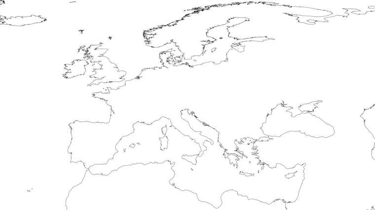
@schulz As I said, that is just the world out of which you can crop what you want. For example, here it is the 2nd and 3rd sixthies of the map from the 30 parallel upwards but cutting most Arctic:
-
@schulz said in Realistic WWII Scenario:
- We could simply assume when maps get bigger the individual units represent smaller military components. Game will probably just cover between Jun42/Sep43 15 months of period (1 round=2 weeks) which also manpower wasn't a scarce resource yet. The problem can also be solved by making units really expensive compared to territory values.
I completely disagree: as long as you have enough resources, forming 100,000 infantrymen doesn't take any longer than forming 1,000 infantrymen, in a strategic game (in which a unit of 1,000 is just a parcel of army-sized units).
-
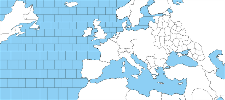
@cernel Probably there is nothing much can be done. If the frontlines going to be accurate, it is not possible to have fewer territories. My main criterion was based on Rzhev salient for example. Here is the current draft which was originally a WW1 map.
-
@schulz Maybe a partial solution is having territories remaning contested across rounds. So salients like Rzhev may be represented as parts of contested territories.
-
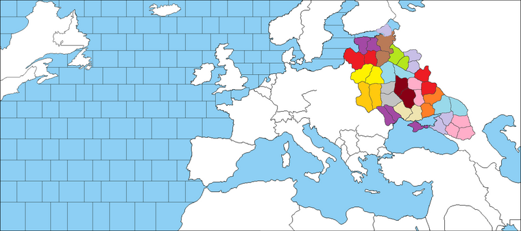
@cernel Amount of territories on the Eastrn front can actually be decreased 50% by merging them with an adjacent territory in expense of sacificing historical borders and relatively small Leningrad and Crimea. Here is example how would it look like.
-
@schulz If you are doing map at this scale, you probably should not have the US on the map at all. Instead, have an off-board area that connects to the Irish Sea and give the US a gradually increasing income.
-
@schulz I love what you are trying to do. No need to go back to larger territories, just increase movement. Unit densities in TripleA are too high anyway, it's ok if if falls. I think if for example infantry movement is 2 and tank movement is 4, and you have ways for players to have can openers or otherwise break through thinly-held areas, you can plausibly say that a turn is 3 months. Then it would not be unrealistic to have production.
-
@rogercooper I am still uncertain about these Atlantic sea zones too.
-
@andrewthree I was thinking increasing movement of all units too but I am afraid it could make calculations too hard. But definitely somethings should be different. What about limiting stacks per territory or limited battle rounds? Terrrains?
-
@schulz I am working on a ww2 Europe map with lots of areas and have both a stacking limit for ground units and greater movement, and limited rounds of combat per battle
-
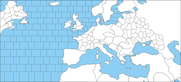
Still progressing;
-
@schulz Are you not giving ships the ability to reach Murmansk or Archangel from the Norwegian Sea?
Beside this, a major issue with such a drawing is that the shipping from the United Kingdom circumventing Africa to fuel the armies fighting in Libya and Egypt (against Rommel) cannot be represented. That is by far the main way that those British armies were formed and supplied (next being India, which supplied mostly manpower). Of course, there were no factories in Egypt producing armaments and virtually no soldier fighting from Egypt was Egyptian.
-
-
Probably not because there would be almost no reason to use this route.
-
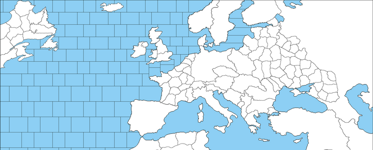
Really I have never seen any TripleA map that UK can reinforce Egypt via Britain. Even extenting the map towards India won't solve the issue totally. Preventing UK to reinforce Egypt would be unrealistic too. Another alternative might be just not representing the Western desert campaign but including Morocco-Algeria and Tunisia only.
-
-
@cernel I don't view a factory as necessarily being a center of industrial production. I view as a logistics center. So in that sense, Britain having a factory in Egypt makes sense. It also makes sense for the US to have a factory in Britain.
-
@schulz what about a connection between atlantic and the gulf of suez or eastern med?
-
@rogercooper Great point
-
@andrewthree I think extending Africa towards Cape Town wouldn't have much effect due to massive distances. Seems like the only reasonable choice is extending the map toward India but that would mean extending Asian Russia as well. There would be just too many territories without much importance.