Crazy Europe: House of Habsburg
-
@wc_sumpton
Updates from here will be just missing connections or XML errors. I won't touch balance again without discussion and feedback. -
@CrazyG
Sorry I don't mean to be behind the curve on the playtesting. Game balance and history are not my forte. But I do like to dabble in the xml, and getting things to work as I think they should. To that effort I reformate xml's, removing spaces, re-tabbing and adding comments. No one see these xml's, I've done plenty. That way when I see an idea, I can try to implement it quickly, to understand a way of doing something.With HoH, I've added bombard as another tech after Naval Cannons, two-turn build ships, and some others. Only in a effort to figure out how to do it.
When I have an idea that seem easy to do, and may help (like the counters at the bottom of the screen). Then I share. If they are not wanted, of if someone thinks I getting pushy. I'll step back and quick. No harm no foul. (I added a AI check system to my copy of Iron War so that the computer didn't have to worry about resources. And its still sitting on my computer.) But I learn, and to me that is what counts.
So again I am sorry. I do cut the unitInitialize out and replace whenever I see an update. I'll try and be better.
Cheers...
-
@wc_sumpton
No need to apologize, I appreciate anyone who takes the time to look at my map.I had the same idea with bombardment. The current tech model isn't intended to be final, just a starting point. Eventually I would like a tree that unlocks as you play. The end goal might for all units to get 3 buffs so the tech icons can be put to full use.
-
-
@wc_sumpton
I was thinking the bombard would count as an attack buff, replacing naval cannons. I'm not a huge fan of just +1 attack or +1 defense buffs, I would rather give units new abilities. -
Still a lot of missing connections and wrong connections.
But the new set up is a dramatic change.
Have I mentioned before what a great WWI scenario this would make?
")
-
@hepps
I have a half way done WW1 thing, but I want to get a grip on this first.I've fixed bad connections in Sweden. Send me any others you find.
My testing is showing that Sweden is now favored over Denmark in a true 1v1, so how much Sweden invests in fighting Russia should be a good source of variety.
-
@crazyg I was just kidding. Got see this through to the finish line now.
-
@CrazyG Quick check update...
Missing connections
SZ 127<-> SZ 134
Connections needing to be removed
France 06 <-> Belgium 06
Netherlands 04 <-> Belgium 01
SZ 128 <-> SZ 109Just what I checked this morning. But I had still noticed issues with Eastern Turkey and some still missing connections in that area.
-
I found a file on my computer with all these missing connections. At some point, I think I updating with the wrong file and removed them.
The problems all seem to be in the areas that we made changes to in the second wave of map creation.
I'm fixing now, will update sometime today. The update will only have connection fixes
-
@crazyg Funny you say that, because I remember already doing this exercise with you once before.
")
Glad you were able to find the file. Should make our lives easier.
-
@crazyg Also when you integrate the new file you may want to look at the connections in Sweden that surround Lakes Vanern & Vattern. there are several connections there that currently shouldn't exist.
-
@hepps
Those were also fixed in the old file -
@crazyg
Hope these will help you with the connection problems:
1_1531421604908_connections_new.txt 0_1531421604907_connections.txt
The connections file is the one with your latest download, removed and sorted. The other file is a new run from the polygons.txt file. All Sea Zones that have connections to land were marked with an 'x' prior to running so any that didn't connect were removed. Those were the only changes. Load both into notepad++ so that they can be compared side by side.Hope this helps in your efforts.
Cheers...
-
Don't know if this has come up... but @CrazyG what did you envision as the default way this game should played? Dice or Low Luck?
-
@hepps
Dice. I have LL on as default for early testing purposes -
@crazyg Good to know.
-
@CrazyG
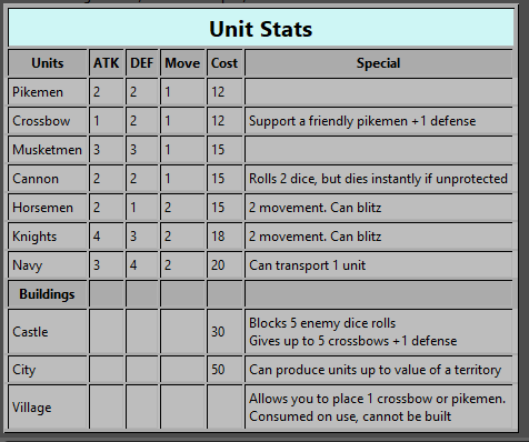
One of the things that I really like about this map is the absents of clutter. With the amount of territories, leaving the names off makes this map seem 'roomier'. But I would think about adding the city names to give a feel of location.Also I would think about splitting up the 'Navy' unit into two different units. A Caravel used to transport troops and receive the movement tech. The other a Galleon that would attack like Cannon (two dice, and added to the supportAttachmentCastleRolls) and receive a bombard tech, but not movement.
I would increase the transport cost of Knights and Cannon to 3 and set canInvadeOnlyFrom to none. The Caravel's transportCapacity could be set to 3 (maybe 4, or set it to 4 as a tech) and isCombatTransport to true.
Any way to both you and @Hepps this is a very nice map.
Cheers...
-
@wc_sumpton This was all @CrazyG . I just drew some pretty pictures. The real beauty of this map is in its design.
-
If not splitting up the "Navy" unit, I would recommend the unit be renamed "Fleet". I feel it is more appropriate to say "I am attacking with two fleets" than say "I am attacking with two navies". A nation only has one navy as far as I know.

Hello! It looks like you're interested in this conversation, but you don't have an account yet.
Getting fed up of having to scroll through the same posts each visit? When you register for an account, you'll always come back to exactly where you were before, and choose to be notified of new replies (either via email, or push notification). You'll also be able to save bookmarks and upvote posts to show your appreciation to other community members.
With your input, this post could be even better 💗
Register Login