Ancient Empires: 222 BC
-
@Name Assuming you are on windows 10 with 12GB and not much else open, you should be fine to push it up to at least 8 GB maybe even 10 GB. Whether that helps, I'm not sure as depends if the slowness is due to memory swapping or if there are certain computations that run that need further optimized and its more of a CPU bottleneck.
-
@redrum windows 7 and I'll test that.
-
Starting clear from a wiki image. Enlarging islands to a size where the even smallest region should fit 10 units at 100% scale, when the image gets to full, x5 size (22400x11200p). Should i got even larger?
Edit: @redrum with 9GB ram allowed, my old map (19000 x 9000) runs significantly smoother in the placement picker, and that's with firefox, gimp and a couple of minor programs open.
-
@Name Here is an example of your Spartan Capital at the sizing you had initially posted.
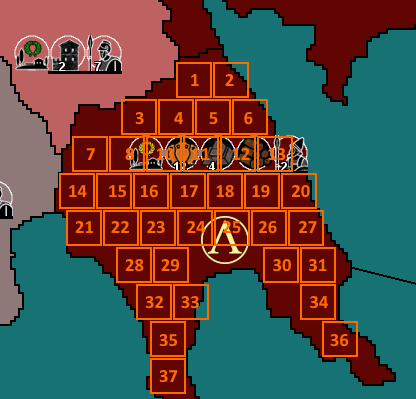
When I did this it appeared your unit size was 36 pixel by 36 pixel.
-
@Hepps Units are 48x48, but I was using a smaller scale for that pic, not sure which one, but 75 makes sense with your dimensions. Mid sized territories like Sparta should be fine anyway, issue was with small and really small ones.
-
@Name Good to know. So that would indicate the limiting factor is ram and probably needing enough so that your map can all be held in memory and avoid swapping which is probably what can cause the slowness. Luckily these days most PCs have 12-16 GB so can handle editing that size of map then. The other obvious question is when you actually run a fully implemented map at that size, how it would run and how much memory it would potentially need. The engine does break the map into tiles when running an actual game so it should be a little more forgiving with memory than the map utilities.
I'd say that probably a good size and as @Hepps shows if you are creative with placements and pack them in then you should be able to get a pretty good number even in smaller territories. Best thing to do would be take a few of the smaller territories and show how placements would look like @Hepps example (though using 48x48 instead). Usually islands need less as they usually don't have as many units so wouldn't worry as much about those (plus they are easier to just make larger if necessary).
@Hepps Out of curiousity, what size is GD?
-
-
@redrum Never had performance issues in game with the 19x9k map, before increasing ram allowance. No clue what will happen with multiple times more territories and units though.
Only thing worth mentioning is that if I reopened the map several times, without having exited the game (5+ I'd say), I experienced from small to total freezes. That should be already known I guess?
I tried something similar to @Hepps' image and any island ter is able to hold 10+ at 100%.
GD is? The larger map made so far?
-
@Name Alright, that's good. I do think we have a few memory leaks when relaunching games without restarting TripleA and a few may be fixed in the latest pre-release.
GD is Global Dominance which is probably the largest map "being made" but it still has a long way to go to become a working map: https://forums.triplea-game.org/topic/95/global-dominance
-
@Name Even with your unit counts I think your original size was pretty good.
If you factor in that most territories will never have 1 of every single; building, resource or unit... then you look like you are in pretty good shape. I have to imagine that you are not planning on loading the entire map and that lots of the map will be rather sparsely filled from the beginning. You may have to reconsider some smaller territories and SZ but if you use a template like Sparta while designing for the areas of the map that are likely to be loaded... you should be good.
-
@Hepps I'm troubled because say 10% of the territories that might get loaded are smaller (often half or less size than sparta).
Also a new map will allow me to better define borders, if I ever get to find a way to draw them more smoothly. How did you do the ones in GD? What tool/settings and about how many pixels wide?
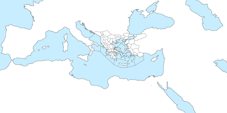
Edit: Here's progress so far (my old playable territories are ready). Drawing my own borders seems faster, I wonder how good they're going to look. Any feedback before I try remaking the XML?
-
@Name I like using either a 1 pixel by 1 pixel or 2 pixels by 2 pixels to draw my base map.
Now as far as lines... I spend an enormous ammount of time removing hard angles and adding a lot of shaping. That is really tedious... but I think it adds to the map in the end.
As far as finishing I would have to run you through a step by step process. But often it involves creating many layers of images.
-
good stuff Lafayette
-
@Name said in Ancient Empires: 222 BC:
@Hepps I'm troubled because say 10% of the territories that might get loaded are smaller (often half or less size than sparta).
Also a new map will allow me to better define borders, if I ever get to find a way to draw them more smoothly. How did you do the ones in GD? What tool/settings and about how many pixels wide?
Edit: Here's progress so far (my old playable territories are ready). Drawing my own borders seems faster, I wonder how good they're going to look. Any feedback before I try remaking the XML?

That is why I think you should double up (meaning 4 times the area and space) on the dimensions you have shown. That going up from 75% to 100% (36 to 48) will mean that you have just about enough placement spots everywhere, as you will have about 2 times as much. So, my suggestion, go for that, directly, if you can, doubling with excel all you obtain, if you cannot.
-
@Hepps I did this with 2x2. Seems to create smoother shapes than 1x1. I was thinking if there's some trick to skip most of the tedious part but I guess that's how it has to be. I'll ask for more advice when I'm about to create relief tiles.
@Cernel I'll try further multiplying the size to x6 instead of x5. I don't want to risk too much lag or mess with the excel method, and size should be mostly fine, since the new map will be roughly 27x13k instead of 19x9k.
-
@Name So the other option to you is also to distort the size and scale of certain regions of a map where you need more space for territories.
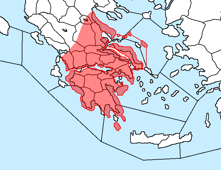
I have done this when drawing many maps... where I expand certain areas relative to the surrounding geography but keep it accurate to its original shape and detail as best as possible. Remember much of this is about gaining just enough space for your plans... so a 10-15% increase in a regions size will often be more than enough to achieve your goals. From there you can often maximize placements by massaging the borders you had initially drawn between the bigger and smaller territories.
Just a suggestion as a way to keep the map size manageable while still getting the desired effect.
BTW this was just a quick rendering as an example. So the detail is not what it could be.
-
@Hepps Yeah. The problem with many maps (a particularly extreme case may be World At War, but there are many) is that the part of the map that it is the most important is usually more detailed, that means tendentially split into smaller territories than the rest of the map, and, playing, it is usually also the busiest part of the map. The consequence of this is that, in actually most maps, you have less space where you need it the most and more space where you need it the least.
Since the time is close, 270BC comes to mind, where you have a busy, important, but very small, "Athens" territory, while the most spacious territory on the map is the near-to-pointless "Sarai", on the far north-east.
I can understand the desire of keeping close to real geography, for flavour, but playability is generally more important.
-
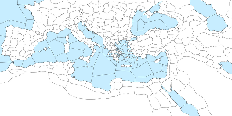
The first version of the complete map is ready. I'll continue with improving details and enlarging some territories before re-implementing to reach the previously playable set up.
-
@Name As I expected, I see there is an enormous territory size difference between some areas (especially Greece) with very small territories and some other zones with way bigger territories. Just a warning this is going badly to impact on playability, because, then, you will have too few placement spots where the small territories are or you will have a very hard time looking around, for possible movements, where the big territories are (very few zones on the screen), or a combination of these two issues, unless you keep zooming in and out, that is not really something you want to keep doing, I tend to think, and anyways it is limited by the need of distinguishing the units.
Anyways, this is a board game, where you can zoom, so I'm not saying you cannot go with such enormous territory size differences (and I still prefer them over cut-outs, like the Eastern Front of Civil War).
Also, I believe the mountainous territories in Italy are strangely located and north Africa is lacking the two major choke points (El Alamein and Gabes, using current names).
-
@Name Looks cool. You might want to consider doing what Hepps showed and enlarge Greece a bit. You'll also want to be careful with some of the really large N.Africa territories as it could mean units can move very long distances across what is mostly desert.