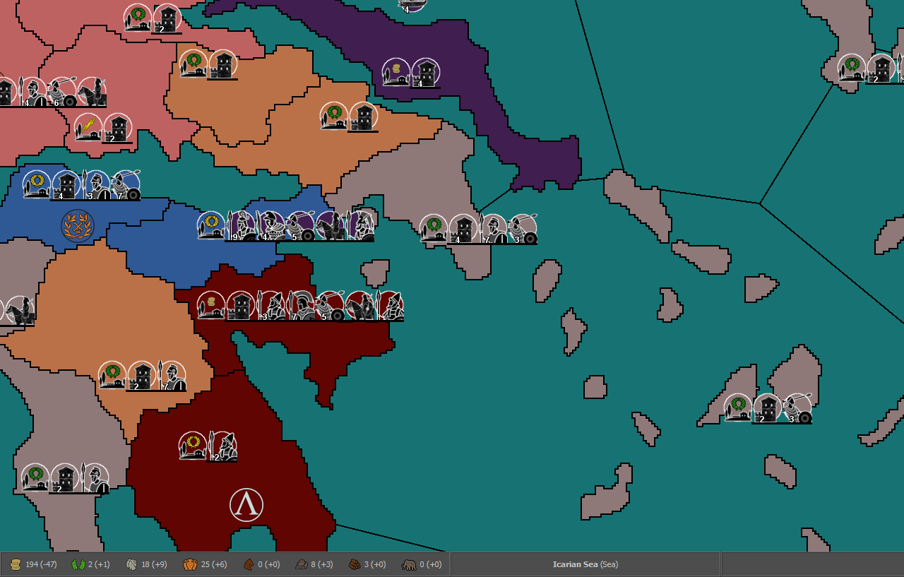
Ancient Empires: 222 BC
-
@Name LMAO! I kinda figured as much... hence why I was trying to get out in front of this given the progress you are making.
")
-
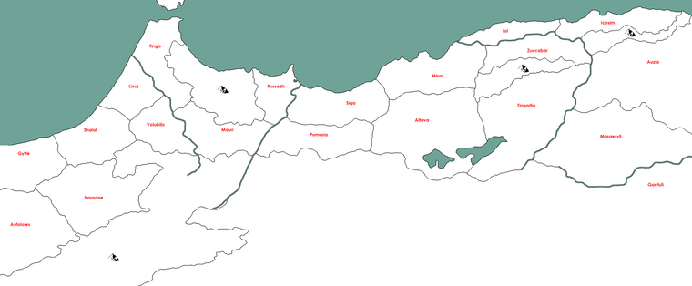
Mauritania
-
@Name Just in case if you will write it anywhere, it is Mauretania, not Mauritania (not 100% sure Mauritania might be a possible variation in English).
-
@Cernel
English:
https://dictionary.cambridge.org/dictionary/english/mauritaniaLatin:
https://en.m.wikipedia.org/wiki/MauretaniaWhy should territory names all be written to reflect Latin?
 Just because romans were there at some point? Might as well just use the name that best identifies a tribe/city/area in a historical context, be it modern English or some ancient language which word has stuck through time or is the only known word.
In general all pre roman takeover definitions/names would be more fitting and "fair". And it would not "bind" a territory or tribe to somehow be original Roman or loyal to Roman rule ... but could instead belong to any empire that came across them (with an attacking army
 ) So maybe try to avoid suffix like -ni and -ia altogether, when posible?
 -
@Frostion said in Ancient Empires: 222 BC:
@Cernel
English:
https://dictionary.cambridge.org/dictionary/english/mauritaniaThis entry is referring to the country of Mauritania.
-
@Cernel @Frostion I was meant to write Mauretania (I thought so far it's only written this way) but was probably influenced by the "Mauri" tribe spelling without noticing. The Romans called Mauretania Tingitana and Mauretania Caesariensis the conquered regions of the Mauri and the Masaesyli (west Numidians) respectively.
This discussion brings in the question of how to name territories. So far I've mostly used tribal names for tribal regions, usually in the modernized English form of the Greek or Latin spelling. Then if I have spare regions I might use a tribal group name for example Celtiberia - or could be Celtiberi(i). Sometimes there are people of the same name in two regions, like Venetii in northeast Italy and Armorica/Brittany, so one will be Venetii, one Venetia. For "civilized" territories either a region or city name. And generally prefering (mostly) fitting single words (Volcae instead of Volcae Tectosages) for UI and ease of XML editing reasons.
-
I would stick to known ancient tribes firstly and secondly ancient city names (cities that were there pre-roman times. It's many times possible to Google these cities' histories and find even more posible names for territories. Many roman cities were build upon already native cities and thankfully romans sometimes kept records of who lived in the area originally).
-
I just love that there is a LOL on the map! :face_with_tears_of_joy:
And a territory called Heppses would be pretty cool as well.
")
-
@Name Since your map is set to start 222 BC, have you based the west african territories on Phoenician settlements of the time or names of tribes? I found this interesting info:
"(...) Phoenicians, they are known to have settled only thirteen trading centers between 1000 and 200 B.C., beyond the Strait of Gibraltar: five in Spain, including Karteia, Gades/Cadiz, Onoba, Gadeira and Tartessus; with eight in Morocco, including Tingus, Silis or Zilil, Asilah, Lixus, Thamusida/Kenitra, Sala, Anfa, and Mugador/Essaouira, which was the furthes south."
There is a nice map also:
http://nephicode.blogspot.com/2018/12/where-did-phoenicians-sail-part-iii.html?m=1 -
@Name said in Ancient Empires: 222 BC:
@Cernel @Frostion I was meant to write Mauretania (I thought so far it's only written this way) but was probably influenced by the "Mauri" tribe spelling without noticing. The Romans called Mauretania Tingitana and Mauretania Caesariensis the conquered regions of the Mauri and the Masaesyli (west Numidians) respectively.
In ancient Latin, you say "maurus" singular and "mauri" plural, that corresponds to English "moor" and "moors".
So, I'm guessing "mauritania" might be allright, hence I googled some, and found this:
https://en.wiktionary.org/wiki/Mauritania#Latin
Maurītānia f sg (genitive Maurītāniae); first declension
Mauretania (ancient Berber kingdom)So, it appears that "Mauritania" is an actual legitimate alternative form of "Mauretania".
However, I cannot recall having ever seen it written anything else but as "Mauretania", as long as not referring to the modern country.
-
@Frostion for the coastline I've used mostly phoenician/carthaginian colonies, and it was easy, many to choose from including several in your link (for example Shalat is Sala). The interior was often more difficult and I had to use tribe names we don't know much of, or that the first reference we have on them is after the start date, in some cases even a few centuries later (same is true for central europian tribes to a degree). In some cases I did a bit of reasonable guesswork or intentional slight misplacement to fit gameplay or fill an area.
@Cernel So no big deal anyway, especially since it will only be used if I add such (greater) region names on the relief, work for much later. But if anyone has preferences on spelling of anything I don't mind much to change things, especially for now that I don't have to change several files yet. Same for alternative tribe/city names for a territory, though I might be a little more picky on those. Maybe we could name Ipsos "Heppses", after @Hepps

-
@Name Just want to say, great work on the territory images so far. You are giving @Hepps and @Frostion a run for their money. For naming, generally I try to go for recognizable names (cities/regions/etc) then whatever I can find to make them historically accurate. I also lean towards using the "english" names vs regional/latin names. Especially for this time period, most players probably won't recognize 80% of the names so its not the end of the world if you have to do some guess work.
TripleA Developer with a Passion for AI: https://forums.triplea-game.org/topic/105/ai-development-discussion-and-feedback
-
@redrum thanks
")
I also lean towards using the "english" names vs regional/latin names.
I can interpret this in a number of possible ways, not sure exactly what you mean.
-
@Name So for example I'd usually choose Brittany instead of Bretagne or other options listed in wikipedia: https://en.wikipedia.org/wiki/Brittany
-
@redrum I see. Was wondering about the second part. Regional as of modern languages or roman/latin versions of them (or even roman administrative regions),
-
@Name ah. I'd probably favor the Roman names as I think they might be more recognizable but tougher call there.
-
Even if you'd go with English names in this one, you would get "Rome" instead of "Roma", but very little else. Most English names would be the latin ones, anyways, by far.
-
@redrum said in Ancient Empires: 222 BC:
@Name Just want to say, great work on the territory images so far. You are giving @Hepps and @Frostion a run for their money.
Easy there tiger... lets not go crazy here.
@Frostion is still the undisputed Admiral of sexification! Though given the progress I'm seeing on this map I will be honest and say I am starting to get a little white knuckled. -
@Hepps said in Ancient Empires: 222 BC:
@redrum said in Ancient Empires: 222 BC:
@Name Just want to say, great work on the territory images so far. You are giving @Hepps and @Frostion a run for their money.
Easy there tiger... lets not go crazy here.
@Frostion is still the undisputed Admiral of sexification! Though given the progress I'm seeing on this map I will be honest and say I am starting to get a little white knuckled. Hey let's not be competitive and just accept the truth in @redrum's statement.
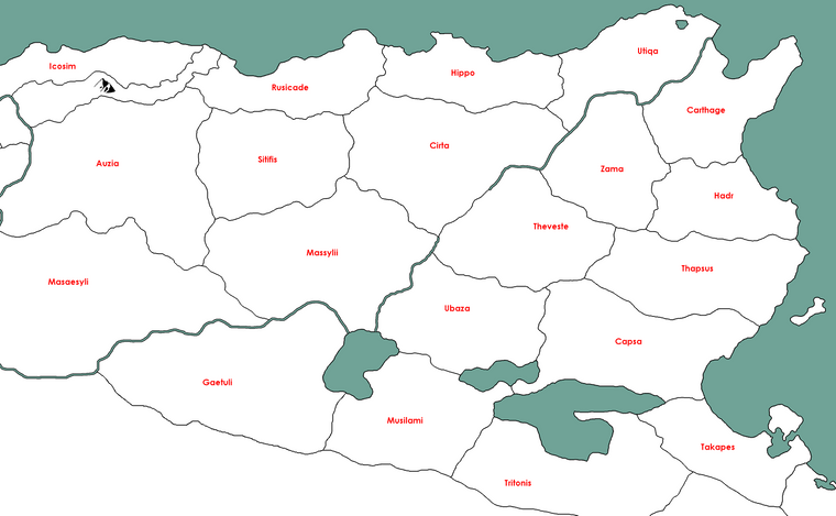
Carthage & surroundings
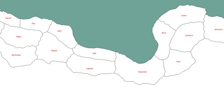
Syrtis & Cyrenaica
-
So my next question is, are there any special considerations on sea territory placement? So far I'm thinking they should be slightly larger on average than land ones, and also following the coastline, with open seas impassable (makes sense with ancient galley navies, they were not really storm resistant so they avoided straying too far from land).
Hello! It looks like you're interested in this conversation, but you don't have an account yet.
Getting fed up of having to scroll through the same posts each visit? When you register for an account, you'll always come back to exactly where you were before, and choose to be notified of new replies (either via email, or push notification). You'll also be able to save bookmarks and upvote posts to show your appreciation to other community members.
With your input, this post could be even better 💗
Register Login