Ancient Empires: 222 BC
-
@Name said in Ancient Empires: 222 BC:
@Hepps Everything but borders is in other layer(s), at least for now until I deside for sure. Or do you mean extra details, ideas etc?
I was just being funny... when your ready, and if you want some pointers for adding some pizaz to the map, just let me know.
-
@Name Quick question... are mountains meant to be impassable territories?
-
@Hepps The ones you can see here, yes, representing high mountains/peaks. But there will also be a mountain territory effect, preventing blitz and buffing some unit types and garrisons.
-
@Name I have to say I am genuinely and completely impressed with the level of detail and your total commitment to adding a sense of realism!
-
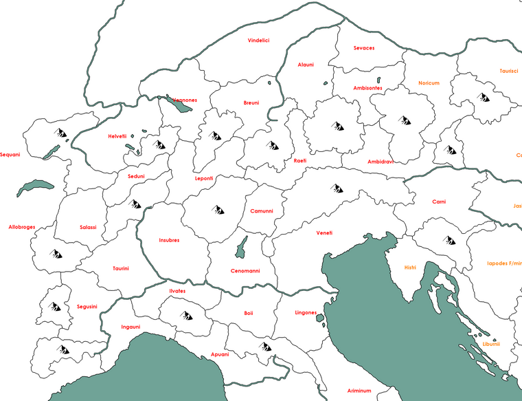
@Hepps Thanks:) Not that I'm deeply satisfied. The research and polish on this can never end, if I want to claim realism. Anyway, here's the Alps WIP, probably the hardest part (so far).
-
@Name Still map maker porn to me!

-
@Name I am glad to see you are adding comparable detail to the entire map and bringing a greater parity to territory size when compared to Greece across the map. Well done.
-
@Hepps It makes more sense from almost any perspective this way, I was just trying to skip extensive map and XML work with the excuse that tribal areas won't have many players anyway.
-
@Name I agree with your decision to "hunker down" and make the extra effort to add the detail that makes the most sense.
-
@Name After reassembling the pieces it looks even hotter. Looks like you are about 30% there.
-
Ancient Empires seem like a serious map project with a real good chance to become a playable game
 Yay! I think this is a rare thing to happen. Most map making seems to start and end during the conception / idea phase.
@Name I hope you are just as insistent and perfectionistic when it comes to all the other different aspects of the map as you have been in regards to drawing borders. If so this can become a real nice map

How do you end up handling the big rivers? Was there to be a few bridges along rivers? Where will crossings be set? At places good for the gameplay or places that could be considered realistic and/or historical?
How big pixel-wise is your working image? I mean do you work with a drawing that you most shrink down at some point or are you drawing it 100% sized to "what you see is what you get" ingame?
-
@Frostion Thanks, I also hope I'll finish it and it will be enjoyable. I think I'll be even more focused on other parts, such map detail only got into the plan due to advice by people here (and after some mapping "accidents" due to ignorance).
The map is 22400 x 9400 and ment to be played best at about 55-70% zoom (what you've seen is at 100%). I'm a bit concerned now that I'm adding high terriotory density almost everywhere. Could it lag in game, could it take too long to finish a game? Victory conditions could help with the later I guess. For sure now it's also going to take quite a while for the XML.
I used mostly @Hepps mapping method, but making it easier on myself. I cropped a strategy game map to the region I wanted and scaled it up x5. Did the coastline black lines "by hand"(with pencil tool), smoothing the effects of scaling up. Then I used a fitting rivers/lakes map, region map and heightmap, saving time over google maps copy-paste (as per @Hepps advice). It might contain some minor innacuracies this way, but the ancient landscape wouldn't be exactly the same as today's anyway. Drew borders, rivers, mountains etc (again pencil tool), using the extra maps as layers/guidance, while researching each region I wasn't too familiar with for tribe names and estimated locations. Mostly wikipedia and it's maps, as it already was a quite massive task to go deeper.
Rivers were chosen for being too important to ignore or being suitable as borders (so not always the larger rivers or tributaries were chosen). For now I have them in a different layer. It might stay as a relief, with rivers being just some of the borders. Else once/if the map is ready and good enough I could make them territories and spam @redrum to implement penalties for attacking over rivers. Not sure yet

@Hepps I'm also done with Gauls and the southern Germanic tribes between Gaul and Dacia. Will upload pics later. I'd say maybe 40% of the map done now.
-
@Name said in Ancient Empires: 222 BC:
@Hepps I'm also done with Gauls and the southern Germanic tribes between Gaul and Dacia. Will upload pics later. I'd say maybe 40% of the map done now.
Looking forward to seeing the progress. Enjoying very much watching your creative process.
-
North of the Alps

North Gaul

South Gaul
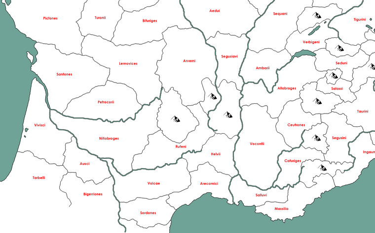
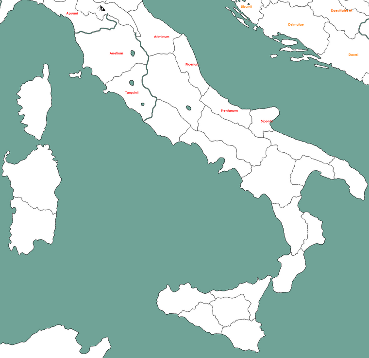
Edit: Forgot Italy
-
@Name I wouldn't be nervous about too much detail creating lag.
I think the main thing creating lag is the size of the map, meaning how many 256x256 images it will be made up of. I think the engine is totally indifferent about what these picture show (bit colors?), but the amount of 256x256 pictures needed to load seems to affect graphical rendering / tile-loading time.
Also AI lag seems to be very much affected by unit movement calculations. So I think it makes a whole lot of difference, wether your map has a lot of 3+ movement units or not, who would really put strains on the AI calculations of possible moves. Unless @redrum has upgraded the AI's brain at some point
 I think this could still affect the map.
@All ... Have anybody had experience with the amount of unit pictures, PU markers, decoration pictures etc. being a problem that resulted in loading lag? I don't think I have. I have only seen the tiles being slow to load up.
I have never used the engine zoom and forced my map to zoom to something specific. I am not saying that my approach is better, but I would do detail/graphical work in higher than 100%, then resize it to what should be 100% in game and use this to split into 256x256, not using map zoom. Reason for this is that placement system is not flexible in regards to map zooming. A territory cannot fit more units just because it is zoomed to be bigger. So I don't see a point in using another zoom. And I would guess that forcing the engine to zoom to something else that 100% puts a strain on the engine, even though probably small. I would use 100% units and 100% map, and if the player likes to use like 50% map zoom (proportionally shrinking units), that would be up to the player. But you could choose to "experiment" and prove me wrong, so that we all can take your solution into account for further map development. And maybe already now, make your map in a way where you were ready to redo some steps. (I have done this before by having Iron War map done in two different versions, on like 25% larger in territory size than the one I finally released)
Another topic; I hope whatever map zoom approach you use, that you avoid jagged edges in the detail tiles and even in the base black/white image. Its a real shame to see this in otherwise nice maps

"Penalties for attacking over rivers." I am sure if we cry enough about it, some dev would make some sort of connection options that modified unit attack stats or something

-
@Frostion I've loaded a slightly bigger map and it was ok. Not worried about that, but "XML overload" due to more units/territories to manage. AI things as well. Ships and Cavalry will be at around 3 movement, but those will be rather limited units requiring special resources, I guess no more that 10-15% of the units that can move.
On the zoom thing, it's designed for 100%, but because the map is huge and some territories rather big, it's advisable to play in a more zoomed out version for better view (I think 50% makes the units too small but a bit above it plays better than 100%).
I didn't get you on jagged edges (and their relation to zoom?).
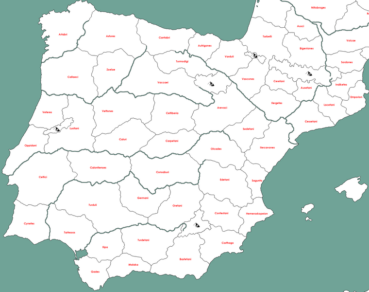
Iberia
-
@Name said in Ancient Empires: 222 BC:
I didn't get you on jagged edges (and their relation to zoom?).
No relation to zoom in the engine. It is just that maps that was made out of a territory border drawing that was originally smaller, then zoomed in to make larger territories, then made into 256x256 final detail tiles ... look awful. I know that some player do not consider aesthetics important, only gameplay, but I am not one of them

-
@Frostion I see. Don't worry, I did the borders after scaling the image to avoid this. Some parts may not be perfect but non of them look terrible imo. When I'm done and before restarting the XML I will upload the full map to get advice and feedback on minor details.
-
@Name I think what @Frostion is trying to say is... although your base map HAS to be done in a completely pixelated finish during the map making process... that is lines have to be completely black with no antialiasing, there is nothing preventing you from using a more pleasing image for the game itself. The original image does not need to be what the player looks at.
You can take the base map image and create a more pleasing finished image for the game...
So you may start with this...
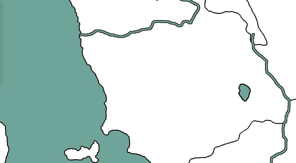
Where all your lines have no blending at all......and turn it into something like this...
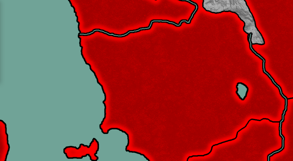
Where the lines look far more natural.Now bear in mind I just did this quickly as an example. The; weight, thickness, blurring, etc. can be played around with during the process.
-
@Hepps Learning to do something like that is in the plan
