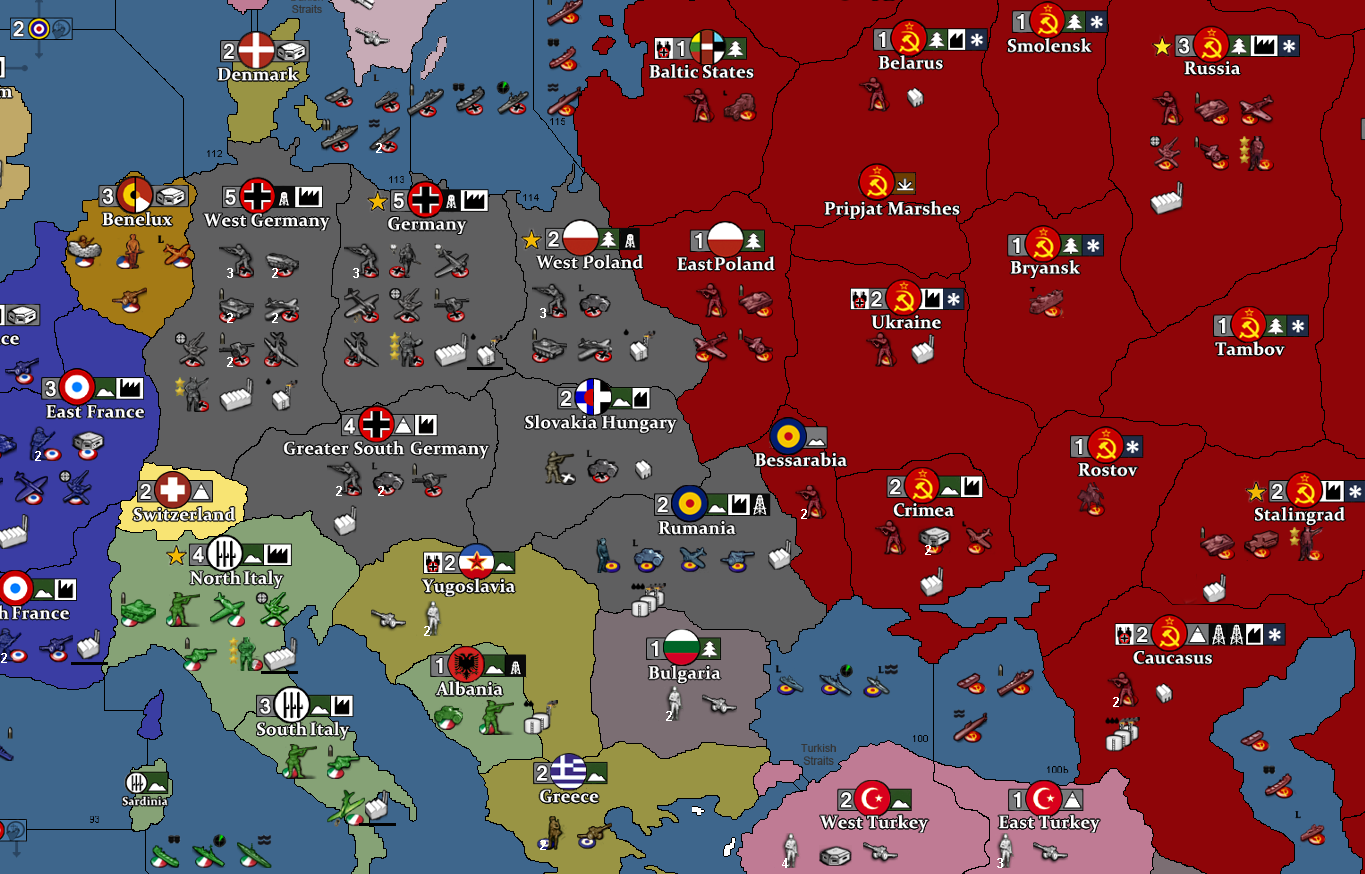
TOTAL GLOBAL WORLD WAR II- fusion & clean-up PROJECT
-
Thnxs Belee... I dive into it soon....
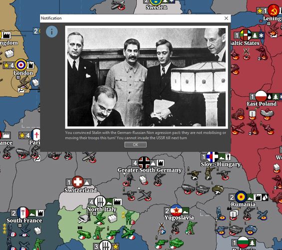
now working on some notifications with historical pics to get some flavour...
anyway... I take a break posting in this forum besides essential questions.... -
You could also use photoshop for unhistorical notifications, it would be very enjoyable.
-
@Schulz good idea.....
-
@Schulz: Okej it took me 1,5 day but original country flags look good too...
")
-also worked on waves that feel bit real but not too distracting.. and coast / border shades...... So I return to the coding and send out some HELP requests concerning some matters I have a hard time to solve.. enjoy your weekend! <br>!!
-
Sea zones and coasts look awesome. TripleA really needs a basic tutorial how to make sea zones and coastlines like that.
-
Hi @ebbe Got your message. Can you explain exactly what it is that you're trying to do again ?
-
@beelee : Thnxs: I want to implement Winter Season ... like in Hepps' WWII TOTAL, but then impactspecified for each unit type... like with Terrain Effects..
I tried with Terrain Effect implementation but failed...then WcSumption was so kind to give me a possible way to solve it,
14 days ago in this forum, it but I don't get it working...
.and it takes away too much precious time for ; )......And I am determined to **have Oil/Fuel, Terrain Types and Winter season together ** in this scenario: As I think these were essential elements in WW2...
... I made a 2 step winter.. first Arctic and then more general Nordic winter... they dissappear the opposite way again in spring...
but fail on the terrain effect connection.. I have limited skills in coding unfortunately... more like Copy Adapt Paste Copy Error error fix ..
 ")
wc-sumptions' idea:
-
@ebbe post your xml of what you currently have. Another map that uses oil is "Iron War". Idk if it has weather. Might give you some more ideas.
-
-
@Belee: I send you the XML code ( still under construction) Winter implementation-attempt at -> 7394-7688 thnxswwIIglobal41_1st_edition@Belee.xml
-
@ebbe wow where did it go ? I saw it earlier when I skimmed through but it's not here now
-
I skimmed through this a bit. The only thing that jumps out is you have two "unitAttachment" s for "winterSign"
<attachment name="unitAttachment" attachTo="winterSign" javaClass="games.strategy.triplea.attachments.UnitAttachment" type="unitType">
<option name="isInfrastructure" value="true"/>
<option name="canBeDamaged" value="false"/>
<!-- <option name="unitType" value="infantry"/>
<option name="faction" value="allied"/>
<option name="side" value="offence"/>
<option name="dice" value="strength"/>
<option name="bonus" value="1"/>
<option name="number" value="1"/>
<option name="bonusType" value="ArtilleryBonus"/>
<option name="impArtTech" value="false"/>
<option name="players" value="germans:italians"/>-->
<!--<option name="bonus" value="1"/>
<option name="unitSupportCount" value="20"/>
<option name="bonusType" value="infantry_bonus"/>
<option name="attack" value="0"/>
<option name="defense" value="0"/>-->
</attachment><attachment name="unitAttachment" attachTo="winterSign" javaClass="games.strategy.triplea.attachments.UnitAttachment" type="unitType">
<option name="isInfrastructure" value="true"/>
<option name="canBeDamaged" value="false"/>
<option name="movement" value="0"/>
<!-- <option name="unitSupportCount" value="20"/>
<option name="attack" value="0"/>
<option name="defense" value="0"/>-->
</attachment>Idk if that would screw anything up or not. So right now, the winter unit shows up and goes away correctly, it's just not having any effect on any units ?
-
I don't see a "territoryEffectAttachment" for "winterSign" either. Using wc's example
<!-- A winter territoryEffect -->
<attachment name="territoryEffectAttachment" attachTo="Winter" javaClass="games.strategy.triplea.attachments.TerritoryEffectAttachment" type="territoryEffect">
<option name="noBlitz" value="whateverUnit:and more"/>
<option name="combatOffenseEffect" value="infantry" count="-1"/>
<option name="combatDefenseEffect" value="infantry" count="-1"/>
</attachment>So where you have the 2nd unitAttachment for winterSign, turn it into a "territoryEffectAttachment" and add all the -movement units. Use the "Mountain" one right below it for a template.
-
@beelee : thnxs : - I indeed removed "territoryEffectAttachment" for winter temporary thinking it caused other trouble... and 2 wintersigns? hmmm that is messy: I fix that and test again!
-
Okej: working on this some hours: concerning issues with the previous discussed WINTER EFFECT: it is still not able to reset: does anyone know if the : -reset- option is okej in following?
<option name="territoryAttachmentName" value="TerritoryAttachment" count="territoryAttachment"/>
<option name="territoryProperty" value="territoryEffect" count="-reset-"/>I think that's the point......
-
@ebbe I'll try and look at this closer later tonight. It seems if you have a unit "winterSign" that modifies whatever is in the same TTy and you remove and replace it, you shouldn't even need a territoryEffect because the unit winterSign is creating the effect. The effects should just be added to winterSign in unitAttachment.
-
WINTER EFFECT RESET ISSUES 1...
@Belee : that is indeed what I hope could work:I tried it this way :
A WinterSign Infrastructure unit from a Cooperative Dummy Player to avoid conflict when placed....
with a supportAttachmentWinterSignEffect with a minus bonus... not sure if a minus bonus will work.... but still this would be very random for all units....
Another approach could maybe be via: a tech:
<attachment name='techAbilityAttachment' attachTo='upgrade_lev_1' javaClass='TechAbilityAttachment' type='technology'>
<option name='defenseBonus' value='1:tank'/>
<option name='attackBonus' value='1:tank'/>
<option name='movementBonus' value='1:tank'/>Nice adaptable for every unit but that looks a difficult way ,
In both cases I could make a Opposite solution if negative bonus is not allowed: I could create a triger to have a non winter situation: giving all units bonus and then withdraw that bonus in winter... hmmm... I give it another try: and will strip a version of all other triggers to try wc sumptions concept... to be sure not another trigger might be disturbing....
I still believe this could be working.... Give us Winter in the battlefield...
bolded text -
WINTER EFFECT RESET ISSUES 2: So : I tried again with a safe stripped game file, implemented Belees remark and a tested with only Inf & Armour in a Winter region of Canada.... WINTER all works as it is static set in Territories attachments...BUT the reset doesn't happen: maybe I oversee something as it looks so logical... if anyone feels like to have an eye on it... welcome...! --> ( so Player: X is a Cooperative dummy to avoid conflict by placing Snow Sign. ) : File: ww2global42_2nd_edition.xml and hej forum visitors: forgive me my Neanderthal-Programming talks... and spam... I am still learning
-
@ebbe yea dicked with this some more and I can't get -reset- to work with territoryEffects either. Which is too bad because that'd be an easy way to do it.
Guess can try a unitAttachment. That's gonna be kinda sloppy but i think you can get it to work. Make a Winter player allied to everybody and skip as many steps as you can. Give it the Winter Unit and the unit and supportAttachments. Then you gotta trigger it's removal and placement for whenever it's supposed to be active. Just start small until you can get it to work. Then add the bells and whistles.
I'll f with it some more after bit.
-
Sorry been very busy lately. I just tried a winter territoryEffect and it seemed to work very well for me. What I did was create the effect:
<territoryEffectList>
   <territoryEffect name="winter"/>
</territoryEffectList>
...
<attachment name="territoryEffectAttachment" attachTo="winter" javaClass="games.strategy.triplea.attachments.TerritoryEffectAttachment" type="territoryEffect">
   <option name="combatOffenseEffect" value="infantry" count="1"/>
   <option name="combatOffenseEffect" value="armour" count="-1"/>
   <option name="combatDefenseEffect" value="infantry:armour" count="2"/>
   <option name="noBlitz" value="armour"/>
   <option name="movementCostModifier" value="armour:fighter:bomber:" count="2"/>
</attachment>
I added the fighter and bomber to my test. Then my conditions and triggers:
<attachment name="conditionAttachmentAlwaysTrue" attachTo="Russians" javaClass="games.strategy.triplea.attachments.RulesAttachment" type="player">
   <option name="switch" value="true"/>
</attachment>
<attachment name="triggerAttachmentClearWinter" attachTo="Russians" javaClass="games.strategy.triplea.attachments.TriggerAttachment" type="player">
   <option name="conditions" value="conditionAttachmentAlwaysTrue"/>
   <!-- You will need your own list of territories here -->
   <option name="territories" value="Fall:S. Fall:Ironspikes:Gallgorlad"/>
   <option name="territoryAttachmentName" value="TerritoryAttachment" count="territoryAttachment"/>
   <option name="territoryProperty" value="territoryEffect" count="-reset-"/>
   <option name="when" value="before:russiansCombatMove"/>
   <option name="uses" value="3"/>
</attachment>
<attachment name="triggerAttachmentMakeWinter" attachTo="Russians" javaClass="games.strategy.triplea.attachments.TriggerAttachment" type="player">
   <option name="conditions" value="conditionAttachmentAlwaysTrue"/>
   <!-- You will need your own list of territories here -->
   <option name="territories" value="Fall:S. Fall:Ironspikes:Gallgorlad"/>
   <option name="territoryAttachmentName" value="TerritoryAttachment" count="territoryAttachment"/>
   <option name="territoryProperty" value="territoryEffect" count="-reset-winter"/>
   <option name="when" value="after:russiansNonCombatMove"/>
   <option name="uses" value="2"/>
</attachment>
I also created a territoryEffects directory under map and added a winter.png. When I hover the mouse over the marked territories during the 'Winter' the icon showed in the status bar and unit movement was restricted. When 'Winter' was over the icon in the status bar was gone and unit movement was no longer restricted.
Will try to help more time allowing.
Cheers...
Hello! It looks like you're interested in this conversation, but you don't have an account yet.
Getting fed up of having to scroll through the same posts each visit? When you register for an account, you'll always come back to exactly where you were before, and choose to be notified of new replies (either via email, or push notification). You'll also be able to save bookmarks and upvote posts to show your appreciation to other community members.
With your input, this post could be even better 💗
Register Login