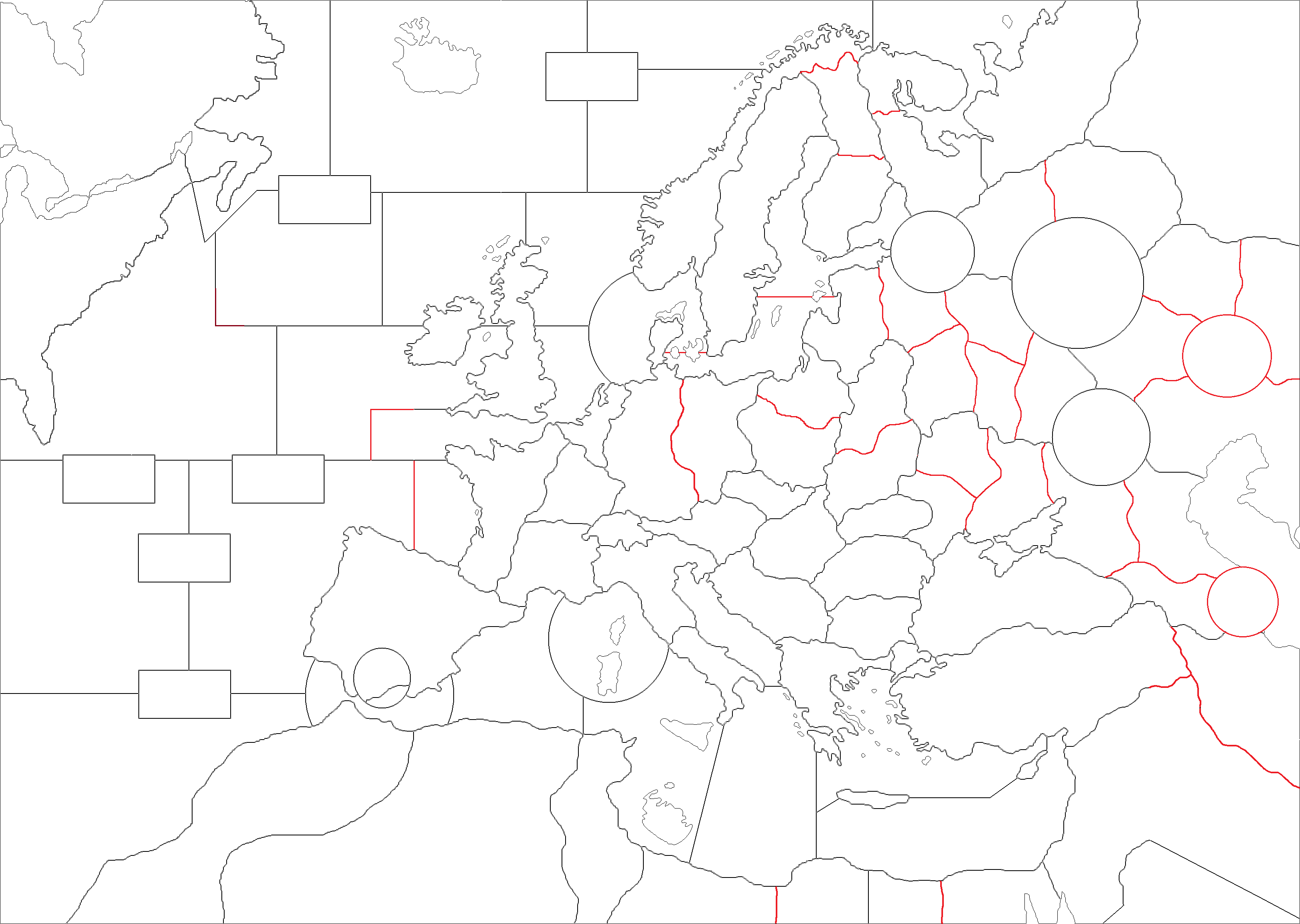
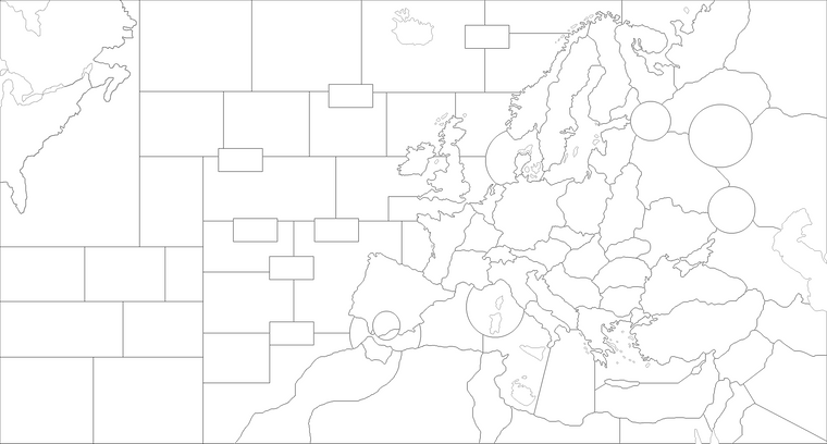
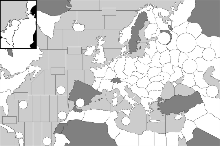
Possible revision on Europe (1999) map
-
- Eastern Germany is safer now.
- Probably there will be East Prussian and Ukrainian factory for Germany otherwise its seems hard to advance in the Eastern Front.
- I think it is better to cancel just two sea zones in the Atlantic rather than increasing movements of naval units.
- There are probably too many sea zones in the Mediterranena maybe some of them should be merged.
-
@schulz Good initiative. TripleA is really missing a non-complex intermediate Europe map: you go directly from the current small Europe (with only 3 territories between Berlin and Moscow, like in Revised) to the very big New World Order (with 8 territories between Berlin and Moscow). Europe 1940 would cover that, but it has politics and a questionable geography (for example, Moscow being closer to Stalingrad than to Leningrad and even missing to show Kuybyshev as a capital of Russia).
A problem of the map are the huge distortions coming from under-representing the vastness of the Atlantic Ocean with respect to the seas around Europe. I agree that it is reasonable to make the Atlantic relatively smaller than it would be, yet I would certainly not make this matter worse by removing the sea zone you removed from the Atlantic: that there are only 3 sea zones between America and France (and 2 between America and GreatBritain, which means you go from one to the other in only 1 movement (!)) is ridiculous if you have 2 sea zones between France and Norway (The distance between Calais and Kristiansand is 892 km, whereas the distance between Brest and New York is 5,375 km, that is 6 times as much!). Moreover, having a fairly big Atlantic is opportune better (or should I say less worse) to represent the battle of the Atlantic (chiefly making it harder for air units to reach submarines).
Other changes I suggest are
- Having the same number of sea zones between the USA and either of Norway, France, Spain and Morocco (I realize that Spain does not matter).
- Having a circle instead of an enormous Malta island.
- Making Sicily bigger.
- Making Sardinia bigger.
- Making Cyprus bigger.
- Making the LowCountries bigger.
- Giving more space to Kursk.
- Making EastGermany more in shape in representing also Czechia.
- Showing Spanish Morocco (it doesn't matter).
- Making the Azerbaijan circle bigger.
- Bringing back Syria.
- Bringing back Palestine and Transjordan but merging them.
- Especially if having Norway bordering Russia, splitting Norway into two territories.
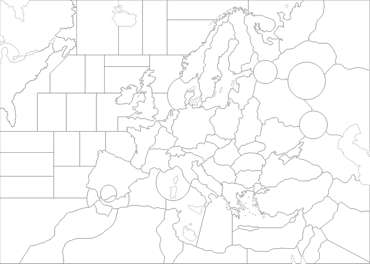
Done as said:
EDIT: I've remade some of the new sea borders so to avoid convoy zones being adjacent to more than 3 other zones.
-
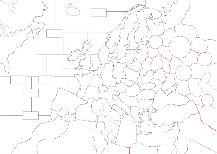
I've modified the drawing of the map, updating my previous post. Be sure to take as reference the most recently uploaded image.
-
- After reconsidering, I think I'd go with 5 sea territories betwen USA and Morocco/France/UK/Norway and all naval vessels moving by 2.
- I have moved USA westward to have more space in the Atlantic, but still the new sea borders looks a bit ugly to me. Probably the boxes in the atlantic had to go.
- I can't create an island surrounded by only one sea zone, because it gives error. New Malta should touch both of the sea zones.
- I would remove Spanish Morocco to have moe clear borders.
- I am not sure if it is better to remove Finland's Arctic coast because I would want to make Finland less vulnerable to Allies invasions.
- I would prefer slighly changing Finnish and Karelian borders to keep Lapland-Leningrad distance 3.
-
@schulz With your current drawing, there are actually 4 zones between America and either of France and GreatBritain.
Besides, I can easily agree with 5 sea zones in between of America and France because I would agree with many numbers from 4 upwards: more sea zones in Atlantic is better if you intend to try to represent the battle of the Atlantic, but having a good representation of that is something I don't believe I've ever seen. So I hope you'll be able to make it worth it.
As I said, I believe you should assure all convoy zones being adjacent to no more than 3 (sea) zones because otherwise they are going to be actual sea zones (as they may create an actual path).
However, a movement of 2 for sea units, with 5 sea zones wide Atlantic, implies that every ship moves less than 3,000 km in one round. With a speed of 20 km/h, that means one round is only about 1 week. If the game starts in June 1941, getting to the end of the war as per history would take about 200 rounds. Moreover, virtually no production would make sense if you have the figure of 1 week per round (as land units, like infantry divisions, take several months to be formed). This is not very consistent also with the territories draw in the Soviet Union: there, based on Barbarossa, assuming there is no combat round limit, I would say one round is supposed to be about 1 month (not 1 week). Objectively, sea units should move of something like 8 spaces or more with the latest drawing: my suggestion was to reduce the chronic under-representation of the movement abilities of sea units (common virtually to all late modern TripleA games).
You can certainly create a land zone entirely surrounded by a sea zone: many games do that. However, the sea zone name ought to end as "Sea Zone".
-
@cernel Correct. I just couldn't have figured out a easy way yet to make all these distances 5. Also Canada is still problematic because It should have 5 distances to Morocco-France-Norway and N.Africa like USA.
But if ships are going to be faster than 2 what is the point of having more sea territories in N.Atlantic? 3 sea zones between USA-France with 2 ship speed is the same with having 5 sea zones between them with 4 ship speed. I think adding more sea zones but keeping ship speeds at 2 has its own advantages like its easier to keep German navy alive and harder to reinforce UK and its surrounding sea zones.
Please could you draw Atlantic to make all USA-Canada and Morocco-France-Norway distances 5 if it is possible?
I have figured out a way to represent battle of Atlantic by randomly spawning a few German subs in N.Atlantic each round. I have all these codes and I would like to implement it.
-
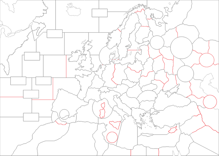
What about this Atlantic borders:
-
@schulz I think you have gone out of your way and widened the map far too much. I don't actually think there is much of a need to widen the map at all to achieve a 5 sea zones in between of America and Europe. Besides, I would keep, as the only exception, 4 sea zones in between of America and GreatBritain/Ireland but only via the northerly route. I realize it is not as much of a problem for a virtual game as it would be for a board-game, but it steel feels like a waste of space.
By the way, the southernmost convoy zone is adjacent to 4 other zones, making it an actual sea zone (representing a significant area of the sea). In order not to be representing actual sea areas (thus remaining a somewhat abstract element), all convoy zones have to be adjacent to no more than 3 other zones (all sea, of course).
If you want, I can draw something like what I believe is wanted while keeping the original wideness of the map.
-
@cernel Yes, please send your example.
-
-
Sea parts are completed. I would definitely add either Romania and Finland along Italy to make it more multi firendly.
-
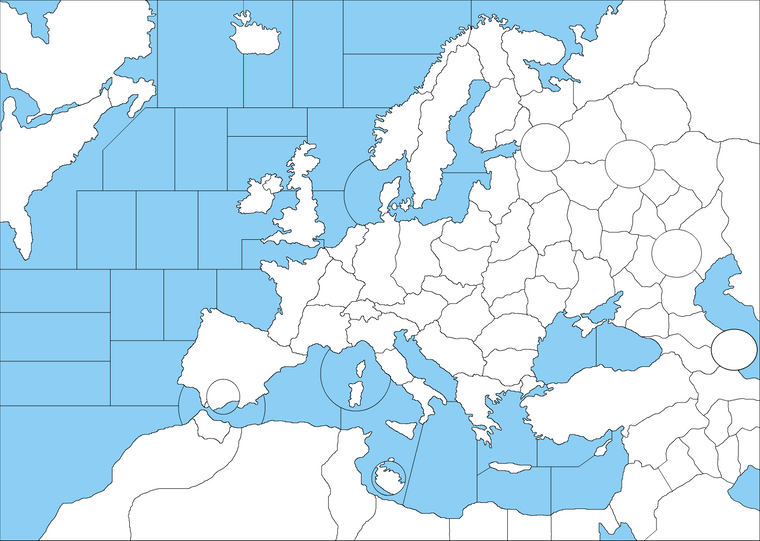
@schulz Here it is the proposed map.
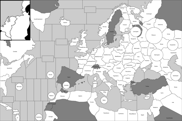
Here it is the same map without the names.
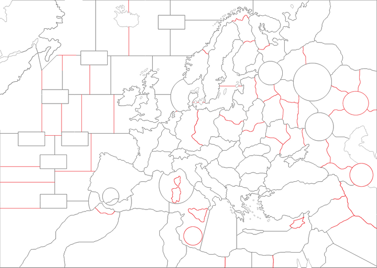
An important thing is that I reconsidered how the eastern front should be drawn.
Firstly, I've added an impassable Ladoga lake correctly to depict a possible siege of Leningrad (so that you can reach Leningrad with land units through only Vyborg, Novgorod or the Baltic sea). Unfortunately, having to represent the siege of Leningrad on a map of this scope means having two territories, for land movement, in between of Leningrad and Moscow (which is relatively too much since there is only one territory between Moscow and Stalingrad). Nevertheless, a correct representation of Leningrad is more important.
Secondly, if you trace a line from Leningrad to Stalingrad, this line passes very close to Moscow, so at least one of the fastest ways from Leningrad to Stalingrad should pass through Moscow. As, after adding the Ladoga, going from Leningrad to Stalingrad through Moscow takes 5 movements, nowhere should there be less than 4 zones between Leningrad and Stalingrad (which is also consistent with the fact that the cities are 1546 km apart whilst Berlin and Moscow are 1609 km apart and with 4 territories in between of them too).
Thirdly, I added an impassable lake Onega.
Moreover, as the most important naming change, I've now Smolensk adjacent to Moscow (since they are only 369 km apart in reality). This also means that the eastern part of Poland can be represented (which is common in TripleA games). So now the "East Poland" of the original game is back at the same place, except being now split into two territories.
Notice the box on the upper-left corner (an otherwise virtually useless portion of the map): it is to give some additional placement spots to a few small zones and WestGermany (to be used only once all spots on the main map are allocated). It would be advisable also to add a square wherever the last placement spot of these zones is on the main map so that players may know that, as long as that square has no unit in it, there is no need to check the box for more.
Mostly for the redrawing of the Atlantic Ocean, I've actually enlarged the map some (now it is 3600 per 2400 pixels, instead of the original 3241 per 2305 pixels). This should also be good to have it fitting better on 4k monitors.
This drawing took several hours to make and should be one of the most realistic (and easily the most realistic to date) TripleA style division of the North Atlantic under the concept of having at least 4 sea zones between North America (excluding islands) and both of Europe (excluding islands) and Africa, every sea zone being about 500 to 1,000 km wide.
In particular,
-there are 5 sea zones between NorthUSA and either of Spain, NorthwestFrance, GreatBritain, Ireland and Iceland, as well as Morocco and every African territory west of Sahara.
-there are 6 sea zones between NorthUSA and either of Gibraltar, Aquitaine, LowLands, Norway, Finnmark.I've reduced the number of convoy zones to 5 and have had them loosely bordering what may be the most important sea routes.
Still, sea zones about 500 to 1,000 km wide are way too big to make sense with fighters having a mobility of 4 zones. Such a combination would mean that land-based fighters are able to reach ships (possibly, submarines) up to about 1,500 km away from the coastline, make combat and return to the starting base. Such a figure is wildly in excess of the capabilities of any single-engine aeroplane (and many bombers) of the time in the theatre and still beyond what the North American Aviation P-51 "Mustang" would have been able to do in 1944 (as a P-51B with two 108 US gallons tanks (one on each wing) would have a combat radius, when escorting bombers, of about 1130 km, and that started to be available only since December 1943 yet was never operationally used in this configuration before February 1944). The figure of about 1,500 km of combat radius for a single-engine fighter was reached (and exceeded of a few hundred kilometres) only by the Republic P-47N "Thunderbolt" (meaning only the "N" model of the P-47), which will actually never see any combat outside the Pacific and will start being delivered in numbers only in 1945 (only 24 of these planes were delivered before 1945).
http://www.joebaugher.com/usaf_fighters/p47_13.html (This is a very rare (and maybe the only) case of an operative WW2 single-engine fighter for which a mobility of 4 or 5 would be justified for 500 to 1,000 km wide zones, and it fought only in the Pacific and only in 1945.)
I hereby suggest reducing the mobility of "fighters" (representing of course also light bombers) to 3 (instead of the current 4) and also reducing their cost to 10 (instead of the current 12) to rebalance.
On the European side, this would mean that fighters based in GreatBritain cannot attack WestGermany and fly back to GreatBritain, which is something that some fighters (like a P-47 with a 200 US gallons drop tank in 1943) would be able to do, but which virtually no fighters in 1941 and 1942 were able to do (either because they were actually absolutely unable or for failures in developing and fielding adequate drop tanks) and which most fighters of any European or American nation will remain unable to do until 1944. Of course, with only two air units in the game, very rough approximations are mandatory. Due to the fact that the European zones in the map tend to represent much shorter distances (because Europe is over-rendered) than Atlantic and American zones do, being unable to operate over most of WestGermany from GreatBritain would imply a combat radius of less than 500 km (for example, Hamburg is 560 km from GreatBritain and Schweinfurt is 636 km).
So, under my suggestions, fighters would move 3 and cost 10 (bombers keep their 6 mobility and their 15 cost, so they can reach EastGermany from GreatBritain).
The odd movement value (having mobility 3 for fighters instead of only 2) is mostly for giving one additional ferry range point to relocate your fighters during Non Combat Movement (in particular, allowing fighters to move farther than armours on land). It will also allow fighters to attack two sea zones away from their location if there is an adjacent zone on which they can land thereafter.Nevertheless, fighters should be able to attack from a territory to another one if the two territories are separated by a very narrow zone. The most typical example may be given by fighters based in GreatBritain being able to attack NorthwestFrance and come back to GreatBritain (vice versa for fighters based in NorthwestFrance attacking GreatBritain). Doing so would require having a mobility of at least 4.
In order to allow fighters to be able to perform such a combat movement in less than 4 moves, I suggest adding air-only connections between every couple of non-neutral territories which are separated by at least one narrow sea zone, meaning that air units only can always move between such couples of territories using only 1 movement point every time, like if the territories were adjacent (You can take a look at the canals of "Dragon War" for an example of how to use canals so to create air-only connections.).
In the map, every air-only connection is shown with a purely white line (notice Sardinia also allowing to move to and from Tunisia and NorthItaly in 2 moves). Indicatively, every couple of territories separated by a less-than 200 km wide sea channel is likely to be air-only connected.Owning to the new design, I would add to the map the Suez Canal (Egypt), the Kiel Canal (WestGermany), the Danish Straits (DM), the Dover Strait and the Turkish Straits.
The Suez Canal allows fleets to hide behind Egypt if controlling Egypt.
The Kiel Canal allows going from the sea zone of EastGermany to the sea zone of LowLands in one movement (and also allows air always to do so, creating an implicit airway).
The Danish Straits blocks movement unless you control Denmark.
The Dover Strait blocks movement unless you control at least one of GreatBritain and NorthwestFrance.
The Turkish Straits block movement of all air units and all sea units except transports.
On such matters, I think that separating the two waterways out of the Baltic should be better than the somewhat weird mixing of the Danish Straits and the Kiel Canal I previously proposed.
Regarding the Turkish Straits, I advise to research to determine whether or not it was possible for (unarmed) transports of warring States to move through the straits while having military cargo and personnel on board. If not, whether or not empty (unarmed) transports of warring States could pass. I'm unsure on both accounts. -
-
Leningrad is already priority for Germany in most of WWII maps due to its close proximity. Isolating the city from the rest of Russia will make it just too easy target. Also Lake Ladoga was forzen in several months and the Russians were able to establish supply routes hence the city actually never completely isolated for a long time. Though I would be fine with that if there is a simpe way to not make it a super easy target.
-
Really I don't like any kind of boxes.
-
I think Canada and USA should have the same distance to Europe and N.Africa and 5 distance is easier to calculate things rather than 4 distances.
-
Probably I'd go with mostly v3 rules and unit costs. I'd fine with reducing fighter movement to 3 and its cost from 10 to 9 or 8. What about bombers. BTW I would probably disable strategic bombing feature. 15 feels so expensive for bombers.
-
Air only connections would bring unnecessary complexity i guess.
-
I will definitely add Suez Canal, not sure about Dover. I think its better to cloe Turkish straits everything including air units.
I am mostly done with sea zones (completed polygons, centers, xml etc...) and still thinking about land territories. India also will be represented with southeastern Iran. Indian Ocean also connects to Red Sea.
BTW is there any easy way to flatten the southern part of the map?
-
-
@schulz said in Possible revision on Europe (1999) map:
- Really I don't like any kind of boxes.
The box in my design can be deleted: it is there just because that is a virtually useless and difficult portion of the map to represent (everything to the west and north of the Labrador sea): it can be simply substituted with nothing (possibly using the available space for showing a logo or something, like the bottom-left corner of "270BC Wars").
- I think Canada and USA should have the same distance to Europe and N.Africa and 5 distance is easier to calculate things rather than 4 distances.
Are you talking merely from a game-play stand-point? The distance between Boston and Brest is 5077 km (and it is actually farther away if you go by sea), whereas the distance between St. John's (Newfoundland) and Brest is 3531 km.
A thing that certainly strikes me in your design is that Iceland is almost as much far away from Great Britain as the United States of America are (3 and 4 sea zones in between, respectively). Beside islands, Great Britain - Iceland is 817 km, whereas Great Britain - USA is 4318 km!
Also, in your design, Iceland is closer to the United States of America than to Great Britain, while the distances would be, respectively, 3428 km (for 2 sea zones, so about 1714 km per sea zone) and 817 km (for 3 sea zones, so about 272 km per sea zone).The sea zone of the English Channel seems doomed to have some massive overflow lines (being so small).
-
-
Yes, purely for gameplay reason. It is just easier and there isn't really a reason constantly forcing US player to move its troops to Canada. It makes playing with US harder.
-
Good catch. Iceland should be moved to East.
-
-
@schulz said in Possible revision on Europe (1999) map:
- Yes, purely for gameplay reason. It is just easier and there isn't really a reason constantly forcing US player to move its troops to Canada. It makes playing with US harder.
I wonder if they historically did so, moving US American military units by land to Canada to shorten sea travels through the Atlantic ocean, which is a very common move in TripleA games. Logistically, you would not normally do such a thing, since sea travels are much less costly than going by land.
-
@cernel said in Possible revision on Europe (1999) map:
@schulz said in Possible revision on Europe (1999) map:
- Yes, purely for gameplay reason. It is just easier and there isn't really a reason constantly forcing US player to move its troops to Canada. It makes playing with US harder.
I wonder if they historically did so, moving US American military units by land to Canada to shorten sea travels through the Atlantic ocean, which is a very common move in TripleA games. Logistically, you would not normally do such a thing, since sea travels are much less costly than going by land.
A better solution is giving the US a naval base with bonus movement on the East Coast, so there is no reason to go up north.
-
@rogercooper I'm not seeing that making sense: Canada has naval bases too.
Boston - Brest is 5078km (or rather 5099 if you account for the necessity of skirting Nova Scotia and Newfoundland).
Halifax - Brest is 4429km (or rather 4439 if you account for the necessity of skirting Newfoundland).
So there you have a saving of more than 600 km of sea travel.
In theory, you can save more than twice as much if you depart from Newfoundland, but, being Newfoundland an island, it would make hardly any sense to do so, as you would have to ship units there anyway.
St. John's - Brest is 3531km. -
@schulz Also, why did you remove the circle representing Russia's second capital (Kuybyshev)? If anyone, it is Stalingrad that should not be represented as a circle. The only reason I didn't remove it is because I didn't want to go too far away from the picture of the original map.
-
@Cernel Because Russia would already collapse if Germany had captured Archangel-Astrakhan line.
Hello! It looks like you're interested in this conversation, but you don't have an account yet.
Getting fed up of having to scroll through the same posts each visit? When you register for an account, you'll always come back to exactly where you were before, and choose to be notified of new replies (either via email, or push notification). You'll also be able to save bookmarks and upvote posts to show your appreciation to other community members.
With your input, this post could be even better 💗
Register Login