Proposed Map: Domination 1941
-
Also, here again is the terrain map at 100% opacity.
https://www.dropbox.com/s/rsf949i4qih94c5/terrain world ocean fill.png?dl=0
If one wants adjust the opacity of the relief, or to change the color or detailing of the oceans, or modify/improve it however, they can use that image.
To create the relief, I did the following in GIMP...
Terrain Map set at at 25% opacity for the bottom layer.
From the baseline I isolated the Ocean SZ by color selecting the blue, then pasted that on top of the Terrain at 100% opacity.
Then to get the borderlines into the relief, from the baseline I color-select the black, expand that selection by 2px, fill with white, copy/paste onto the final layer at the top of the relief.
Merge visible for the Relief
Then Anti-Alias, Filters/Enhance noise reduction 4, Blur Gaussian 1. For the blur I did the lowest setting, I think default is 1.5, but I used 1, which kept things a little sharper. Too much blur and it'll make you want glasses at 100%, too little and the edges appear kinda hard/pixelated, so it's sort of just striking the right balance there I guess. But for those lines you can pull from the baseline bitmap for the selections, and just add to the terrain/relief as the last step. Like if one wanted to change any of the borders in the baseline and transfer to relief, that's a good method. Or at least we got all the puzzle pieces available I guess if people want to tinker with it down the road lol
I'd actually be curious to see the next steps, as this is the part of map making process that I'm least familiar with. I'm like low key dyslexic when it comes to parsing a bunch of txt and coordinate information in the map properties and some of that stuff honestly like using the polygon grabber just gives me heartburn hehe, plus I'm a terrible typist so I usually tune out at this part to focus on whatever else. But I'd imagine G40 would be simpler though right, because the XML is already built out for that? Like once it's pushed through and busted up? Anyway, let me know how if we make any progress on that front. Meantime I'm going to double check the units again. As I'm sure I probably missed something somewhere. I mean I banged out so many that day, there's gotta be something that gave me the slip lol
Here's the other stuff again...
Global Baseline
https://www.dropbox.com/s/pcvl7jjpenpld7t/World_War_II_Global 1940 relief 25 opacity.png?dl=0Global Relief
https://www.dropbox.com/s/pcvl7jjpenpld7t/World_War_II_Global 1940 relief 25 opacity.png?dl=0Domination Baseline
https://www.dropbox.com/s/khxkql58g73q1n3/Domination_1940_baseline.png?dl=0Domination Relief
https://www.dropbox.com/s/x1qei5rhc137hip/Domination_1940 relief 25 opacity.png?dl=0HEX Colors
Americans: 026400
ANZAC: 5ba399
British: 9e7035
Chinese: 533c69
Dutch: e77600
French: 0063a5
Germans: 656565
Italians: 6c4513
Japanese: e19521
Mongolians: a13030
Neutral Allies: d9ab6f
Neutral Axis: 6d664e
Neutral True: e7d2b5
Russians: 940000
Ocean: 66ccff
Ice: d2eef4 -
@black_elk
Below are some suggestions for SZ merging, that is removing some lines within the red areas.I did base the removal on not removing G40 lines, but worth checking.
These are only suggestions. (As Im not an avid ww2-er)
-
Sounds good, I'll give it another crack tomorrow most likely to nix whatever ya don't need in the SZ stuff.
Checking out the other thread in map making, I wonder if the gaussian blur I did at the end to soften the borders there in the relief, might have made the under terrain a little hazy, like happened with my attempt at that Iron War tweak lol. I did a quick paste to the color map and it looked pretty much the same to me, but I didn't have it way under the magnifying glass. I think there's probably an acceptable level of blur one could allow, especially since the terrain is more suggested flare here, maybe it's better not quite as sharp? Like when the units and other graphics are laid down, and the eye has something else to cling too besides just the map itself, the gaussian might seem less noticeable. On the other hand if there's a cleaner way to only have that effect on the border lines, that'd probably be preferable. Just to have it separated by layer. I'll take a closer look when I get home later
-
Ok here ya go...
https://www.dropbox.com/s/xnvwl23sf092dia/Domination_1941_baseline.png?dl=0
Let me know if you want to ditch anything else on the baseline. I'll just pull a new relief from that, since I wanted to fix the blur anyway hehe
-
@Cernel
what SZ would you change for this new map.
https://www.dropbox.com/s/xnvwl23sf092dia/Domination_1941_baseline.png?dl=0Transports, Battleships, Subs will move 2
Fleet units Destroyers, Cruisers, Fleet Carriers will move 3
Harbours do not add +1 movehttps://forums.triplea-game.org/tags/thedog
https://forums.triplea-game.org/topic/3741/curated-best-top-maps-triplea-guides -
For what it's worth, I think Sea Zones are pretty abstract in A&A, and naval movement/combat is really kinda hard to make sense of as anything other than just sort of gamey. Whatever you decide on probably the starting unit distribution and the TT values will be the key factor in making it all hum together. I think players will generally tend to shuck along the shortest path available for their transports and usually you end up with just a few very large combat fleets converging on the main chokepoints on either side of the board to face each other down. Sorta playing chicken or cat and mouse till one side offers a gambit or a goof. The balance typically tilts on aircraft and spamming fodder every round for the big naval stand offs, till one side breaks and either has to withdraw or just gets smoked in a decisive blow out. Or at least that seems to be the standard A&A naval dynamic.
I think on the Pacific side, it's good for the gameplay to inflate the values of the TTs in the Central Pacific, like if you want Japan to have some reason to face off against the US there rather than just making the B line for India, or slamming into Russia, as tends to happen in most A&A games, I think that's a reasonable method. In A&A there's just not really enough production contested there to give Japan much reason to sprawl vs the US or ANZAC, but I think you could fix that by juicing the TT values a bit. Then the IJN ships would have more reason to stay forward to guard the contested tiles and shore up their lines there.
Anyhow, let me know what you come up with, and I'll try to get it dialed. Many of those sz subdivisions I made kinda on the fly just based on the what was flying at me from the requests earlier, but people can always just go back and mess with that earlier base if they want. I saved the new one with 41 in the title, so I'll just make it however you want into the next phase heheh
-
@thedog said in Proposed Map: Domination 1941:
@Cernel
what SZ would you change for this new map.
https://www.dropbox.com/s/xnvwl23sf092dia/Domination_1941_baseline.png?dl=0Transports, Battleships, Subs will move 2
Fleet units Destroyers, Cruisers, Fleet Carriers will move 3
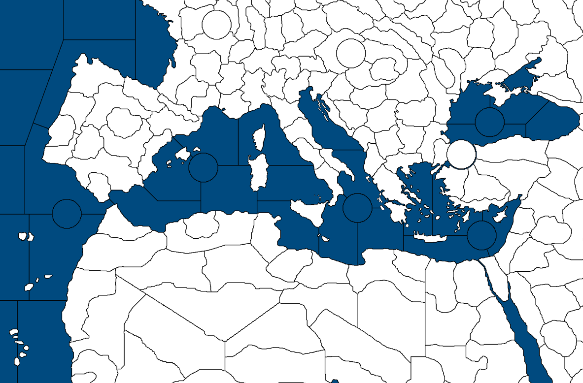
Harbours do not add +1 moveThis is really a weirdly vague question, but, shortly after opening the map, I've been struck by the nonsense that going from Gibraltar to Malta by moving north of Majorca and Sicily takes 3 movements, whereas going to it via would would be the shorter sea route takes 4 movements. Moreover, on the realistically shorter route, there are (as said) 5 sea zones between Gibraltar and Malta and only 2 sea zones between Malta and Palestine, whereas in reality Palestine is farther away from Malta than Gibraltar is.
And I guess you fogot to add a sea zone border somewhere in the Turkish straits?
-
@cernel
Yes, a deliberately vague question, as I wanted your opinion.Thanks for spotting the Med area SZ.
Are they any more SZ that leap out at you that are wrong?
-
@Cernel good eye, must have forgot a break for the Bosporus. That needs to go in for sure!
Hahah yeah, well, I'd only point out that a realistic distance with an unrealistic scale is a bit of a challenge lol. I mean given that Europe is considerably larger and quite contorted, and Africa is considerably smaller and quite contorted, this creates a situation where the Mediterranean is going to become somewhat weird somewhere right? Like there's just more space in the Western Med than the Eastern Med to insert additional tiles given the Global warp.
Probably it would be better for sense of distance from Gibraltar if sz 94 just didn't exist OOB, but of course it does, so that's a bit of a kink lol.
I'd say the ready solution here is to shift Malta back, so that it's as far left in sz 96 as possible, rather than riding the line of that inserted SZ tile in the central/eastern Med. This probably makes the Malta TT rather less useful as a fighter transit, but it's whatever I guess, like I'm not wedded to having it ride a line.
The idea for inserting more sea zones into the Med was basically to push the air routes and give ships a few more tiles to maneuver around each other somehow, esp. along the North African coast, without inflating the other distances too hard. Hence trying to keep at least one route a bit tighter. I guess it could have been the reverse, like an extra Zone out of sz 93, rather than out of 92 or 94, but that seemed less interesting to me than doing it along the Algerian or Tunisian coast, which was a more active warfront. But I guess just remove those breaks? Like I only added them and shifted Malta initially to see how many might fit before it got too ridiculous, but we might have hit that point and passed it. We can just ditch em hehe.
Another option is to do the extra sz breaks horizontally rather than vertically, but you'd get the exact same issue doing that, except then we'd be talking about North/South distances rather than East/West distances, while still basically arriving at the same conclusion that the relative distance between one given point and another is kinda nonsensical sometimes. Either way you're going to get distortion and places where there's just not a whole lot of room to add new zones from the existing G40 ones. Also in A&A there's another factor, beyond just how many tiles are between point A and point B for true distance in gameplay terms, since presumably there are actual naval forces in play too, blocking ready movement along certain paths. My default is to consider distance as the crow flies too, ie 'can a fighter still land there in one movement? Or not?' cause that's a bit more binary with a pretty clear cutoff. Also cause the effects of fighter transits on the gameplay are usually a lot more pronounced than ship movement per se. Naval engagements generally hinging on aircraft in range. But I agree, it's all rather weird, if you sit with it for very long there's going to be cracks haha. NBs and ABs can complicate the distance vibe too, just by adding extra movement if starting the move off a base. The Med has 4 NBs across 5 sz tiles OOB, which makes it more of a lake there I guess. Like Gibraltar to Suez is only 1 move off the NBs OOB, provided there's not a giant fleet parked in your way, to turn that move 1 distance into a move Zero situation lol.
Probably the entire Med could be collapsed into just 3 sea zone tiles, like v3, and that would be more realistic - basically the same movement situation you get with the NBs in play in G40, but then that wouldn't exactly accommodate the other gameplay needs of a G40.
Overall, the med situation is similar to the distortion in the western USSR around "Russia", since the map has to give somewhere. If there's no morph, then Europe will simply appear as an enlarged inset that doesn't align with anything around it, or else it can be realistic in scale, but too small to service the OOB game. Meds got the same thing going on. That is the general situation we get on many WW2 maps, the ones that aren't also trying fit a G40 mold I mean and can just use Mercator or something similar for the warp, like your Big Worlds, or Ultimate Worlds etc, or similar WW2 maps that we see from time to time. Like Iron War has the same thing going on, despite being a fairly gigantic map, so it's a bit of a bind. I'm not sure if Larry or Kevin had a totally specific idea that sz sizes or the number of divisions needed to be consistent from region to region?
Clearly there was some acknowledgement of keeping the distances somehow the same, while somehow further too, just with the inclusion of the NB as a unit there to keep with the playscale. I tend to see that stuff in the same way I view the OOB production values over various editions, where perhaps the initial conceptual model is a bit off from the gameplay now. Like for Production it's really clear that Larry had an idea about what IPC was supposed to reflect and kinda static, but I think that must have had to bend a fair bit over the course of successive editions to accommodate new added tiles and such. For the midscale games you can see that going down a bit for sure I'd say. Perhaps the SZ conception was similar? Like where it started pretty solid and clear, then got hazier over time. I mean you look at the Baltic and see it split from 1 tile into 3 sz going from V3 to G40, and have to kinda wonder about it all, like it maybe gave them some headaches too if they really sat with it for too long hehe.
My quick take here would be to nix the extra zones around Algeria sz 92/94, keep the extra zone carved out of sz 96, but move Malta off that line to be a true island again. At least then you'd have an equal distance between Malta and Gibraltar compared to Malta and Suez by sea, basically 2 spaces from each. If that works for ya, I'll just bang out the eraser and do a quick copy paste hehe
ps. Here's a quick look at how Hepster did his Med in that 1914 game. That seemed kinda interesting to me, though the basic sz splits don't follow G40 there. Like where the sz hits at Tunisia and across Libya, OOB has different lines. Perhaps something like that might still work though, like with rectangular inserts rather than circles or something? Honestly it's one of those things, where I'll just do whatever you guys think best for the ideas you got in mind. As long as G40 looks OK, I'll be pretty happy. For that I think I just need to shift Malta back for the visual right? I remember sliding it a bit right to try and add that sz similar to the way Hepps broke it across a line, but that was a while ago and it really doesn't work for the G40 sz divisions with Malta the way it's positioned there. The Med has been made relatively larger since then as well. So we can change it to whatever you guys think looks cool.
-
@black_elk said in Proposed Map: Domination 1941:
@Cernel good eye, must have forgot a break for the Bosporus. That needs to go in for sure!
With your drawing, however, there is the problem that having that sea zone border on the Bosphorus implies you can load and/or offload between the Aegean sea and your territory in north-western Anatolia, despite the fact that ships which cannot move through the Bosphorus cannot move through the Dardanelles either. Having the border on the Dardanelles, on the other hand, would fix this problem but cause the same problem for the Black sea and your Smyrna territory, instead.
In Europe/Global 1940 there is not this issue because Turkey is one single territory, which is an egregious distortion if you consider that the real Turkey is actually bigger than France and Great Britain combined (yet nothing compared to Brazil being one single territory...).
By the way, in Europe/Global 1940 it appears that the Turkish straits are indeed only the Bosphorus, whereas the official optional rules of V3 mention the Dardanelles (and not the Bosphorus), instead.
-
Yeah the big board is a trip on that one hehe. I'd just put the borderline on either side I guess. Maybe change the color of the water there, to indicate the whole thing is closed from the Dardanelles to the golden horn and grinding rocks. No Argonauts allowed? lol
Frostion has this graphic we can use to help clarify the location of the straits. He has the image titled Bosphorus as well, but the way it's shaped, I'd just stick on the Dardanelles. Probably fits a bit better there, with the focus more on the Med side than the Black Sea side, since that's where most of the starting ships are located.

-
Here is the Med again... I used the double line like Bung did for Straits/Canals, with a slightly lighter shade of blue. OOB and the current tripleA G40 have the break at Skagerrak for the Danish Straits, though I'd probably hang the little graphic pointing more Kattegat, just because of the angle it's at. Basically looks like the Bosphorus graphic above just at a slightly different angle in Frostion's set. He has half a dozen at different angles I think, but nothing quite that vertical.
I'm not sure if you want to add any more?
Singapore comes to mind, but the way the OOB sz divisions are set up, it's not very convenient to do a choke point there. Same deal with Malacca. Basically G40 has SZ lines already riding the narrows, so the split just doesn't really work, cause the existing SZ lines are running parallel rather than perpendicular for a clean break. Like it'd have to cut across more than 2 sz to actually block movement effectively, and the control would probably feel a bit off. Frostion had both in Iron War and it was kinda cool, but he also had a totally different geometry for the Sea Zones in that area than G40 does. They work better with the splits in Iron War, but here not so much.
Messina might work if inserting another SZ tile I guess, but it seemed sorta pointless, since you guys wanted fewer sea zones rather than more in the Med from what I'm gathering hehe. Plus the Med already had 3 weird waterways in neighborhood. So I don't know, just seemed like overkill lol.
If there's something else you can think of let me know and I'll make the adjustments.
https://www.dropbox.com/s/4740bj0l87sbb57/World_War_II_Global_1940_baseline.png?dl=0
https://www.dropbox.com/s/xnvwl23sf092dia/Domination_1941_baseline.png?dl=0
ps. One last quick thought on Singapore...
So if we used this one... or that one, or a flipped version...


Then we could set up a choke between sz 37 and sz 41, and that might carry better as a visual controlled from the Singapore TT.
I guess it could just block sz41 and sz36 from sz 37 simultaneously?
I feel like you'd need to reinforce the idea with the visual if doing that, cause usually Straits only cut across a single border between only 2 sz, but from the tangent of the graphic (if we placed it right and then did a little double line with the blue) maybe we could get that to work? Just so it's not too hard to parse.
Or it could just block at sz 36 I suppose, and that would still be mechanically kind of interesting, even if sort of Alice in Wonderland level suspension of disbelief hehe. Either way it'd be kinda nice if we could get something going. Having a Strait there would be cool as a way to make that pearl a bit more valuable to the gameplay and maybe get the dynamic bouncing between Japan and India to be a bit more engaging. Also it would be nice just for parity with the Europe side of the board. I mean to have at least one in the Pacific, since the other side of the map has 5 OOB.
-
@black_elk Frostion's Frontier Icon is way sweet
") Reminds me of James Bond lol
Reminds me of James Bond lolI think you got it dialed in pretty good. People can just erase stuff right ? I guess adding is different ?
Anyway Rock On !
Hmm Heppster's Rock On Image is gone.
Well anyway Rock On ! lol
Edit
Here he is. Was kinda bummed for a minute lol
-
Haha the rocker!
Yeah I've been giving the units another pass to see if I missed anything. I found one factory-it tech unit that was off and a couple shadows, but otherwise I think it looks pretty good. I was going to put all the current 48px graphics into a sub folder so nothing gets overwritten even if they got the same names or whatever, cause there's quite a few nice graphics in there. Maybe we can upscale more of them as time allows.
-
@Black_Elk
For the canal lines Gibraltar, Danish Straights etc I don't think they should go on the baseTiles png. (As it will mess with the polygon grabber). They are better represented on the reliefTiles or as Frostion has done, they are in the decorations.txt file.@Cernel
Any more SZ that pop out at you and look wrong? -
Sounds good. That would be preferable, because I think with white borders in the relief the straits would slip too far into the background and not be quite noticeable enough anyway. Those subtle changes in color information or the double line, they just kinda recede a bit when the lines are all thicker and white that way, so decorations would be better. The Graphic will convey what's going on with more impact hopefully.
I updated both base files in the dropbox links. Just let me know what further tweaks you'd like to make and I'll bang them out. At this point it kinda feels like whackamole could set in if we linger overmuch lol. Like we could probably hang at this phase till the New Year and split the hairs till we're balder than Lobot, but I would suggest just kinda doing what you think would work well for whatever distribution of starting forces you're vibing on hehe. The stuff we put in the zones and the production values assigned are what will determine the playpattern more than anything else, so it's hard to see it clearly until we start tooling around with more of that stuff. For what it's worth think it's possible to justify many things in this kind of game. Like provided the resulting gameplay delivers the appropriate feel for the start date. Although I definitely like having a consistent conceptual framework to build on for the sense of realism, the OOB game often isn't terribly consistent or realistic either, so that colors it a bit. The shorthand on some of this stuff for me is 'can we make it more fun for the WW2 gameplay if we do X or Y or Z?" Cause if we can, that smooths over many things that might otherwise stick in the craw haha.
Anyway, hope your Tuesday is entertaining! I rewatched Andor for a second time and just hung the Xmas lights! If we can somehow have the troops home for the Holidays, that would kick ass! Maybe it's a target we could actually pull off for G40? The new one will surely take a while to suss out and playbalance, but I'm itching to dive in. I will even try to learn these damn utilities I guess, if it helps things along lol. Though I know myself - flying solo I'd burn out on it for sure and it'll never get finished, so going to need a G40 wingman and a cobra commander to keep it pushing, no doubt! haha
Catch ya in a few!
ps. @Cernel, did you follow along with Hepps' naming conventions for the main tiles in that 1914 map? I have all his labelling for that map which is somewhat similar, cause we started there for the Dom one, but there are a few tile names that wouldn't make sense to me in a 1940/41 context. Also the shifting between urban centers and regional labels feels a little problematic sometimes. Unlike the Alpha Numeric approach of the building off the G40 SZ divisions, the Dom TTs sorta require the names hehe. Once we have the divisions settled, I want to do label key for it, so we have a point of reference for that, but I could definitely use an eye. I think there are spots where it could do with a name change or two, for sure. Also I never trust myself as a typist. These clumsy thumbs lol. I'll post it when I'm finished, but I'm only like a tenth of the way there, cause there's a ton of tiles.
-
@black_elk
For my part I'm done with TT & SZ. I would merge a few more SZ, but like you I wish to keep backwards compatibility with G40.So I'm waiting on @Cernel critical eye for any last comments.
Black_Elk when we have finished with the TT/SZ, for 1941 Command Decision (detailed G40) do you fancy numbering the TT and SZ and putting the numbers & name of the TT/SZ in a text file?
Then for 1941 Command Decision (detailed G40) I will be doing the boring bit, making the centers, polygon, place text files. The xml, bar the TT/SZ and unit positioning is almost ready for testing.
-
@black_elk said in Proposed Map: Domination 1941:
ps. @Cernel, did you follow along with Hepps' naming conventions for the main tiles in that 1914 map?
Absolutely not. Didn't even know about that until I read this post.
-
@thedog said in Proposed Map: Domination 1941:
So I'm waiting on @Cernel critical eye for any last comments.
What map image?
-
@cernel
If you would be so kind, to give this file your critical eye/opinion.
https://www.dropbox.com/s/xnvwl23sf092dia/Domination_1941_baseline.png?dl=0
Hello! It looks like you're interested in this conversation, but you don't have an account yet.
Getting fed up of having to scroll through the same posts each visit? When you register for an account, you'll always come back to exactly where you were before, and choose to be notified of new replies (either via email, or push notification). You'll also be able to save bookmarks and upvote posts to show your appreciation to other community members.
With your input, this post could be even better 💗
Register Login