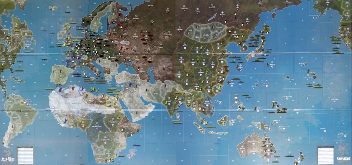
Proposed Map: Domination 1941
-
Agree multi-hp units currently have to be cost-restricted because of the straight-forward ways of abusing them.
changes-
1)Either side can retreat from battle after round 2
2)make multi hit units more common by lowering their price (2hp carriers, 2hp tanks, 3hp battleships)
3)But they can only repair at docks/factories
4)They have reduced functionality if they are damaged
4a)carriers cannot land aircraft,
4b)tanks/carriers/battleships have 1 movement,
4c)if a damaged 2hp tank retreats from battle, there is a 1/6 chance the opposing side captures it.So there are more opportunities to punish
not sure how to balance 2hp jets- you could make them 1/6 chance of dying upon taking a hit but that's not very fun
-
Solid post. I will reply over in this thread.
-
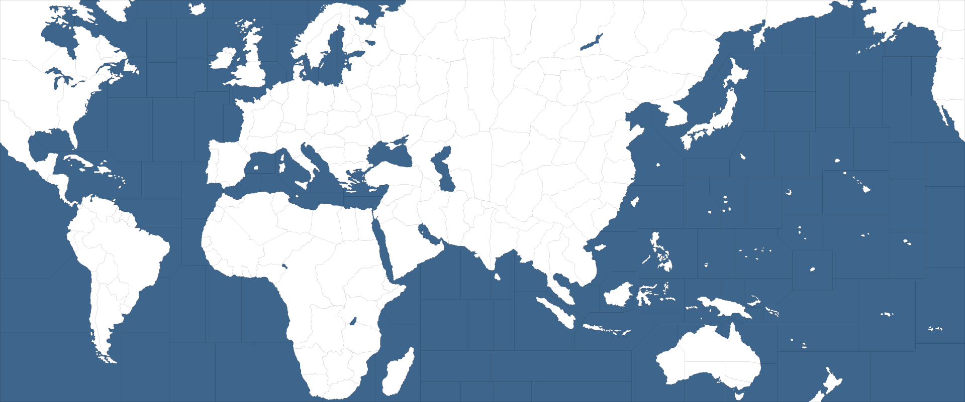
@kurtgodel7 So real quick, I just wanted to show what I meant earlier about how it's relatively easy to expand the map for a larger Pacific ocean. You could do the same with the Atlantic too, but just since the Pac was mentioned.
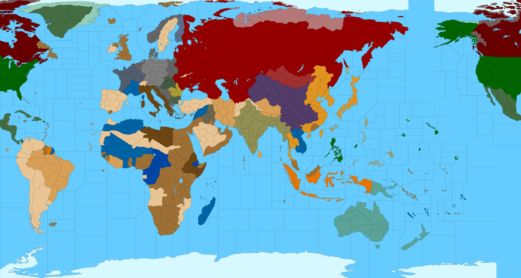
Now this will create a somewhat more realistic sense of scale there in the Pacific Ocean, but there is also a trade off with that, because you will end up with a pretty large area of the map that is effectively unused during gameplay, at least under the normal kind of A&A dynamic/playscale.
The above doesn't seem half bad to me, at least when I'm panned out at the max distance like these previews, but then when I open the thing at 100% and get right on top of it, the deadspace scroll tends to become a lot more pronounced. I guess we could split the difference and have a map that's 16500, or 17000px to shift the Americas and slightly enlarge both oceans?
The 16x9 aspect isn't a hard rule or anything, I was just trying to ballpark. It'd probably end up wider than that anyway, cause I don't think most people would want to see Antarctica, so if you're cropping there I guess might as well go the full distance? hehe
To the point about what the stretch can actually achieve though, I mean you could make the distance between W. Coast USA and Japan 7 tiles or 12 tiles or more, with tons of space there, but in terms of the standard gameplay, that just makes those tiles into places where the USN and IJN will never really go right?
Now one could certainly change that dynamic I guess, by changing how naval movement works in general, or by making those SZ tiles more strategically important/significant to the gameplay (say by giving them PU values or something.) But even then, I would think that players will default to the shortest lines, and only set up pickets where it makes sense either for moving your own fleet into position or for disrupting the enemy's movement lanes. So you likely still end up in the same situation, with lots of tiles and screen real estate that is unused.
But let's take it from the perspective of the Japanese player right, like how do you incentivize them to remain forward with their fleets (directing their forces East), when everything in the gameplay is telling them to ignore it and gear South? You know, where all the island territories and such are located.
So to me that's the real dilemma, and why more accurate projections of the World, like say Mercator or the Equirectangular one, still leave something to be desired. They create large deadspaces where there is almost no activity during gameplay. Spots that just have to be scrolled past to focus on other spots where the action actually occurs. It's not just that you end up with large empty zones like the bottom right corner of the Pacific, but really across the entire board. So sorta the whole point of the initial design was to compress those areas, and make them smaller (more abstract), like the handling of the Soviet Union say.
In a more accurate Projection the USSR would be almost twice as wide, but then half of that space is east of the Urals. You know, where not a lot happens, unless Japan is just stomping across Siberia towards Moscow in goofy ways heheh. This is what the Official A&A maps do, it's just that to achieve it, they make a much more abstract and fuzzy looking globe, to sort of trick the eye and gloss over the many distortions that were made in service of the gameplay.
What I was hoping to nail down is something basically half way between the distortion of the Official A&A boards, and a more accurate rendering to my taste, but the problem comes in those areas mentioned. So sorta like, how big do you really want Africa vs Europe, or how much can you scrunch the USSR before it starts looking silly, or how to get rid of large empty spaces in the South East Pacific, before it starts falling apart and looking weird again... Cause there's a bit of a limit right? Like you can only separate Alaska from Kamchatka by so much before you have to start bending the warp again and pulling the USSR along for the ride haha. You can only shrink Africa and enlarge the Med so much, before it's gotta give somewhere. On this map, true north is variable depending on which TT you're focusing on, though I've tried to disguise that to the greatest extent possible, but it starts to rear up again when shifting and rescaling.
My main priority in creating the initial projection was to accommodate stuff like Global, or AA50 or 1942.2, and these more complex maps were just like a stepping stone on the way towards achieving that. But then people seemed to like the draft concepts. Like Surtur decided to bang out a whole XML for it, which Imbaked and Seig adapted into NML. But originally it was just supposed to be a V3 map, with that kinda playscale and so hence tighter oceans, massive Europe etc etc. But if you know what you're after isn't quite Global or V3, but something where say ships can move 3 or 4 spaces, or where the map is really more like a naval game than a ground game (with ships playing second fiddle like Classic A&A) then you can do other things with it.
So my thought would be to continue refining it in a way that's as adaptive as possible, while still allowing the core baseline to work for the smaller games too. Just so that we can have at least one series of games that all kinda use the same essential world projection, rather than always having to build them up from scratch.
All that just to say that if it's departing from the vision too much here, we can go back later and make it hum, but it's hard to do that when the ultimate game is still kinda nebulous and under formation. Like I know what Global is, and how the playpatterns work there, so I know what kinda stuff might work well for that, but then when we get down to the super divided up type with 4 times as many TTs and SZ it's a little harder. It's basically impossible to design a clutch map without knowing how all the other stuff will work, so I just kinda default to what I have more experience with, which is the more midscale game I guess lol.
-
Oh or how about just doing something more like this...?
So instead of 16:9 Aspect, which is screen oriented, we could do something closer to a 2:1 Aspect ratio, which would conceivably allow the vector to be dolled up and printed out to fit a 6 ft folding table. Or at least for the Global map I mean.
The standard dimensions on that are what, 72 inches by 30? So not exactly 2:1, but in the ballpark at least. I mean you want a few inches to put a drink down usually right? lol
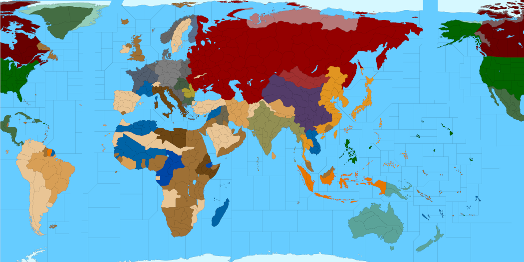
For the Domination map you'd probably need like 4 folding tables and an entire empty garage, but hey, there might be somebody out there who could pull it off lol. Or just like totally showboating at a tournament, just taking up the whole floor heheh
I don't know I'm torn with it, because 16:9 would certainly be cool for the screen display. I mean so you could max zoom out and not see black bars like it's a widescreen movie. 16:9 is a fairly decent print size, cause it allows for some room on the table that isn't just the mapboard. Though I guess if you're truly down you have a card table for that stuff. Still I don't know it's tricky. Basically the Americas and the two Oceans are the easiest to manipulate from what we have thus far. Cause easier to grow the board and tweak sz shapes than it is to redraw and shape the landmasses.
Anyhow, I'm off to eat candy
Happy Halloween! -
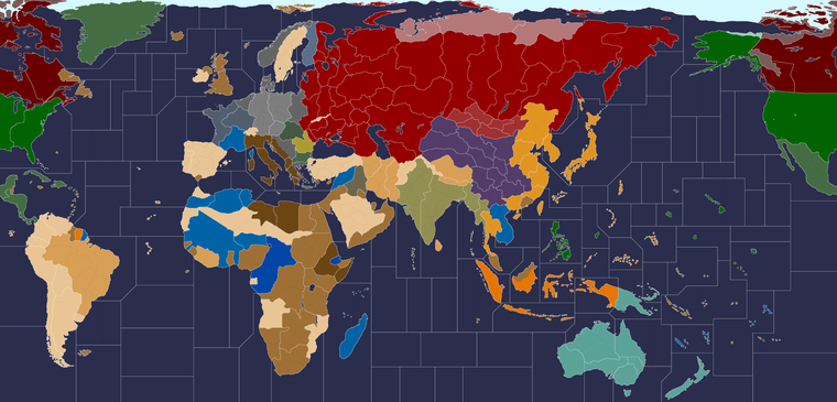
OK here it is at like 16800x8100 px
I split the difference, so about 300 px to the Atlantic 500px to the Pacific. I don't want to push it any further because then I'll have to redraw too much stuff lol. I already had to MechaGodzilla Greenland, and it took a while to align the North American split so the lines would hit in the right spots when it wraps. Hopefully this works.
https://www.dropbox.com/s/7fwyake8wqyunco/TripleA_4k_working.png?dl=0
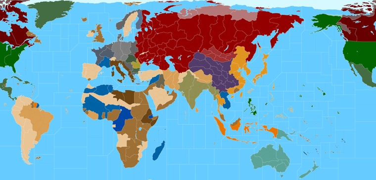
Again with the white lines showing Global TT divisions (unless I missed something) and the black lines showing the subdivisions.
At this point I'd like to just focus on the black lines and not change the white ones too much, unless I missed something and there's a G40 connection error somewhere, basically so we can lock that in and just focus on what we want to change from that point. Like where it add the black lines or how to split horizontal vs vertical or in an L. There are a few G40 Sea Zones I want to rescale/enlarge, but the basic blocking should be pretty close, just need to shift some lines to make the tiles more proportionally consistent.
Let me know if that looks alright
Catch ya next round
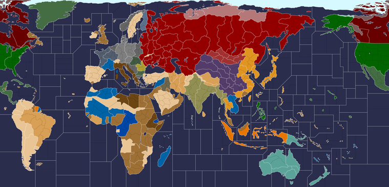
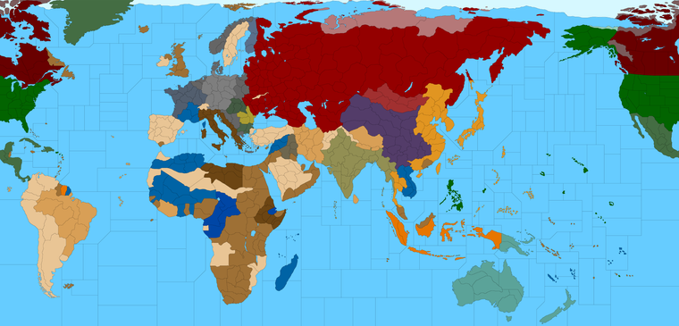
ps. Here's the same with the Oceans done dark again, just cause I was hunting down floating pixels lol. I did the white borders at 5px and the black at 3px here, cause the new aspect ratio makes the 25% previews a bit smaller. I prefer the light blue ocean myself, but it's helpful to adjust the value between the two extremes while working. The black lines pop harder against the light blue ocean, so for an actual relief like in G40 scale, we'd probably want to reduce the opacity on those and make all the subdivisions semi-transparent, just so they're more backgrounded.
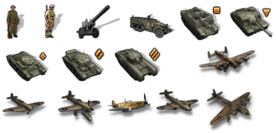
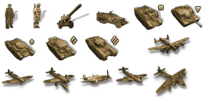
ps. Here are the Brits with no roundels. The Naval units, factories, AAguns etc are generic, which I think is good anyway, so we basically just need the ground units and the aircraft. Since those were given more individual/national flare by Frostion. I added an alt look for a long range fighter and an alt bomber, just to have something for tech stuff there. Tanks he already had in light/medium/heavy categories, as well as an SP Artillery unit (the square) unit and a Tank Destroyer (inverted triangle). So a pretty decent spread. I had to rework the dropshadows to remove the roundels. I Made it a little tighter on the shadow cause that was easier for me to pull off in GIMP and made it so the fighter units wouldn't have to stand quite as tall. There might be some categories missing still for desired unit type, but least it looks pretty cool for something new or at least new-ish
")
-
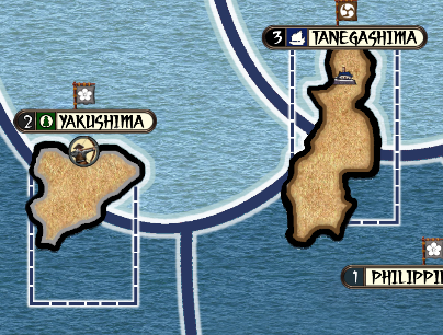
@black_elk it looks as if you're missing the Fiji Samoa SZ and SZ 18 between Philippines and JPN to make it 3 spaces again
Edit
Looks as if EUS to GIB missing one too. I thought you had an earlier one that fixed those, but i can't find it now -
@beelee Sounds good, yeah I've just been tinkering most of the morning with doggo distractions, so I've surely erased one or two along the way by accident when trying to align the Americas lol. Trying to get a similar sweep going, but with the more important spots made a bit more jumbo on this pass. Sorta like this around Hawaii and such... but like halfway through erasing the lines and redrawing them probably hehe. Some tiles are too skinny some lost a side maybe. Haven't made it back to the Atlantic yet, my eyes started to glaze over, so I broke for dinner. I'll give it the finer toothed comb tomorrow for sure.

What I'd like to do is pull Philippines to the right so we can get a bit more room there without it looking too wonky. That way Iwo and Saipan and such won't seem so far out of position. The small islands are already highly abstracted and enlarged, so I think it makes sense to center them a bit on the tiles and enlarge the sz tiles a bit in that whole area of high activity. Do the same for Truk and the Dutch Islands etc. For the Atlantic the sz that border Canada all need to be enlarged so they can eat into the transit zones a bit more. Then for the black lines we can divide up the interior zones. OOB there's a lot of distance between the big island groups. So sort like slip and slide everything a bit maybe just so it's a bit closer to the gameboard?
I'd be cool if we could visualize in a simple way the concept that all those sz Tiles are enlarged and the island views are basically like magnified insets for each tile. I was trying to think of a good method. Like perhaps where you see a small dot on the island location, then have the shape of the sz tile somehow indicate a zoom? Maybe with diagonals or some kind of geometry for that to kinda sell it. Most of those islands would be invisible even with the super warp, but the player also needs a ready spot to click hehe. And then I find having some variety in the shapes is helpful to make them feel more distinct. In the 1914 game I think were conceived as coaling stations and such. G40 doesn't show most of the islands, even Sakhalin got nixed there right. But having some extra spots felt like part of the charm I guess on this one, so I didn't want to erase anything lol. I still think it use a bit more zone for camping out hehe.
-
@black_elk :flexed_biceps:
-
Im really liking the new unit look, that is without the roundels, it looks cleaner and certainly less cluttered so

Here is Ebbes idea from our The Shogun Advanced, you might be able to squeeze a 2x2 unit dashed outline, (120x120px ish) for Gibraltar and Malta. The dashed outline could apply to any island chain.
.
Here are real world flying distances found using
https://www.distancecalculator.net/From To km miles New York in USA to Murmansk in Russia 6456 4012 New York in USA to Liverpool in UK 5325 3309 Natal in Brazil to Dakar in Sengal 3005 1867 Puerto Williams in Argentina to Cape Town in South Africa 6746 4192 Cape Town in South Africa to Perth in Australia 8697 5404 Tokyo in Japan to San Francisco in USA 8266 5136 Brisbane in Australia to Puerto Williams in Argentina 10067 6255These might help/hinder your SZ jigsaw

-
@thedog said in Proposed Map: Domination 1941:
From To km miles
New York in USA to Murmansk in Russia 6456 4012I think Slim Pickens took a different route lol
Good Stuff
-
Yeah sz18 is super obnoxious lol. Just the fact that the Guam sz has to touch the Ryukyu sz without making it too small. Like you'd really prefer the useful sz to be larger instead of having their space eaten up by a transit sz. The Fiji sz is fairly annoying too, just how it has to touch Line Is sz.
When loading up Bung's Global map had to recall that sz66 where the "Bung and Veqryn Fighter graphic displays is actually on the far lefthand of the baseline, since the map split makes it seem like it's on the bottom right when it wraps the two edges together lol.
Anyway while I was tooling around down there I realized that Hepps must have morphed China at some point in the 1914 game, probably to fit more zone around Port Arthur or the many Shanghai spots. It created a contour that was rather less round, so I went back in a doctored that coastline up a bit. I managed to get a little more space in some of the zones that seemed more important. At some point it's probably simpler to just start moving the Islands if people want more space, but I was trying not to break too much as I went.
Didn't get as far as I'd planned on account of that, still haven't revistied the Atlantic yet, but this is where I'm at right now hehe

ps. Just for comparison, this is what our players are using right now for G40...
And here's an image of the physical board... I'd say Bung did a pretty alright job for fidelity there, but we're shooting for something with a bit less distortion. Still, it gives a sense for how the TT/SZ sizes measure up on the relative scale.
So anyway, I need to go back in and make some corrections for the G40 split. But I'd say we've definitely made some progress.
-
@black_elk :beaming_face_with_smiling_eyes: :flexed_biceps: :smiling_face_with_sunglasses:
-
Alright I took another crack at the Atlantic.
I couldn't see any real advantage to preserving the OOB geometry of some of the shapes, especially where in most cases it would just serve to pointlessly enlarge the transit tiles at the expense of the more important coastal tiles.
My logic there was that it really doesn't make a whole lot of sense to have a bunch of massive rectangular tiles in the middle of the oceans, when the reality is that the player will only ever be passing through them for like 2 seconds during a movement phase right? At least in G40 terms. I tried to prioritize the coastal tiles whenever possible. So the places where the ships will actually end up, and be stacking to the ceiling, I tried to make those spots larger. That was the rationale anyway. We can revisit it if it looks too different from OOB for you guys, but in a lot of instances I find the OOB sz shapes not particularly interesting visually, and not particularly useful given the mechanics at play, so I kinda just went with my gut on that stuff.
-
@black_elk I Dig It
-
@black_elk Unfortunately for the eyes, Borneo is one and British in the game (even though it was mostly Dutch in reality).
-
@cernel This is an interesting dilemma that I've been wondering about. So there are a number of Territories in Global that are either not depicted at all, or else depicted but assigned to the wrong faction for the start date.
I felt OK about assigning Sierra Leone to the British cause at least I got a reply from Larry confirming that that one was an error, a couple years back, but then there are quite a few other spots like Sarawak, Honduras, the Falklands, or the various British possessions in the Gulf etc that are simply folded into TTs controlled by another faction.
Then there are of course a number of territories assigned to US control in G40, that would seem to be more like a 'sphere of influence', for spots that came under the American Aegis during lend lease or after their actual entry into the conflict, or even a bit later in the timeline. These can also be a bit inconsistent depending on the spot.
My thought would be perhaps to leave these tiles in tact but to remove their connections in the xml and then assign ownership based on some neighboring tile that does exist and G40 and might make sense?
So for example, perhaps Dutch Borneo could be assigned to Celebs? Since the connections would be removed it wouldn't effect the gameplay, just how the ownership is displayed, until Celebs is conquered in that case. Or like same deal for Honduras or Jamaica (which don't exist in G40) these might be attached to British Guinea (which does). Or like maybe Bermuda gets attached to Newfoundland (which I just realized now is not drawn correctly, not sure how that happened lol). Anyhow, not certain if that works for people. It might be too confusing with a land border I guess.
The alternative would just be to get merciless with the eraser when making the G40 version I guess, which might be simpler, though I found it hard to justify removing some stuff at this point. You know like why have a map that shows Line Islands but not Sakhalin, when the later is definitely visible from space and the former definitely isn't? heheh
Anyhow not sure of the best solution for that stuff, but I figured I could figure it out once all the rest of it was dialed lol
ps. Here it is with Labrador drawn correctly. Must have got switched up in that 1914 map. I raised Greenland a bit so Labrador sz could be larger. Went back to light blue. All the black line sz subdivisions were just kinda ballpark right now. I'm not certain what people are interested in for the larger map, other than making Japan and W. USA 7 moves apart like Kurt requested. Not sure how you guys want to handle the Atlantic, I guess let me know and we can start tooling around with those.

-
@Black_Elk
Just the white SZ and Ships move 2, this is kinder to the AI and AI time taken to calculate moves.
There are plenty of SZ for hide subs in.
Aircraft do move further over SZ, but that is the trade off.
or
White SZ and Black SZ, ships move 3, AI takes longer to move.So I vote for just white SZ and Ships move 2.
Thoughts?
-
I think it's certainly possible to do M2 ships with more SZ divisions, depending on how one wants to handle the starting forces and the production. For example, in the Pacific, if the USA has to mobilize everything out of W. USA then M2 is a big nerf with more SZ divisions, but if they can produce units out of Hawaii then the nerf is less extreme. Or like same deal with the opening round. If the playpattern is like virtually every A&A game where the Allies have a bunch of units that just get destroyed immediately and have to be replaced, then M2 with more divisions is pretty rough. On the other hand if their starting forces are more forward and aren't just getting wiped by the Axis on G1/J1, then you can create a playpattern that doesn't have the Allies stalling out quite as hard. Since the white lines are just G40, even there the playscale recommends some form of M3 I'd think, since G40 has those naval bases and such. Iron War has a map that is about as divided as G40, but uses an M2 Classic/Revised playscale, but it works alright because of the way the starting forces are distributed. Hard to say what's best. I think M3 whether standard or from naval bases is one of those things that can be hard to get the head around if you're very used to say Classic or 1942.2. One of the things that M3 does is kinda mess with naval pickets. It's hard to set up a DD block, if the opponent can just do an end around heheh. I think the map above could probably work using the standard v3 rules, provided it had a new unit set up that accounted for the extra spaces. I agree though, since my thought would be to make something that is compatible for AI solo play, anything that's going to make that drag should probably be avoided when possible
")
Here is it is showing the all blacks for comparison
-
Yeah, you make some good points, even more reason for white SZ with ships M2.
-
I can't get over how just changing the border lines from white to black makes the exact same shade of blue for the oceans appear to be a different color, just from that alone. Such a trip! Our perception of color is so strange heheh. It's all relative I guess
Hello! It looks like you're interested in this conversation, but you don't have an account yet.
Getting fed up of having to scroll through the same posts each visit? When you register for an account, you'll always come back to exactly where you were before, and choose to be notified of new replies (either via email, or push notification). You'll also be able to save bookmarks and upvote posts to show your appreciation to other community members.
With your input, this post could be even better 💗
Register Login