Proposed Map: Domination 1941
-
@black_elk Sweet ! Won't forget to dust Guam now lol
-
No doubt! hehe
This is like my third or fourth attempt at a naval base harbour unit lol.

I wanted to get something that would sorta stitch the buoy and anchor graphics together, and still look sufficiently like a 'naval' base, even if the center for the unit is displaying somewhat inland like tends to happen, least on the current map. I thought something like that might be kinda cool, with a flash of blue through the looking glass.
I encountered a weird issue in Bungs G40 map though when I went to load it up. No matter what dimensions I set for the image, it's always being resized into a smaller square. Kinda weird, didn't have that issue with the Airfield. For some reason the Harbour unit just always wants to shrink down to a 48px square. Still a mystery for me, I've been messing with it for a while now. I'm just going to move on to the next things I guess
-
@black_elk wow dude way detailed. Will rock on Big map.
That's weird with the resizing. Maybe @Cernel knows why
Edit
Just saw this at git https://github.com/triplea-game/triplea/issues/11243Never seen it before. Maybe try and make the old image the same size as the new ? Idk lol
-
Thanks!
I think I figured it out. I had another instance of tripleA open in the background, so maybe it was remembering the old size or something. I killed em all in the task manager and when I reloaded the harbours scaled up proper hehe. Looks like this now on Bung's...
I think I might lower the anchor and raise the glass. Like even as I typed that just now, it seems like the right thing to do heheh. It would make the anchor pop a little more I bet. I'll do that tomorrow. But anyhow, I think it should do the trick for an NB with a tiny bit more noodling.
-
-
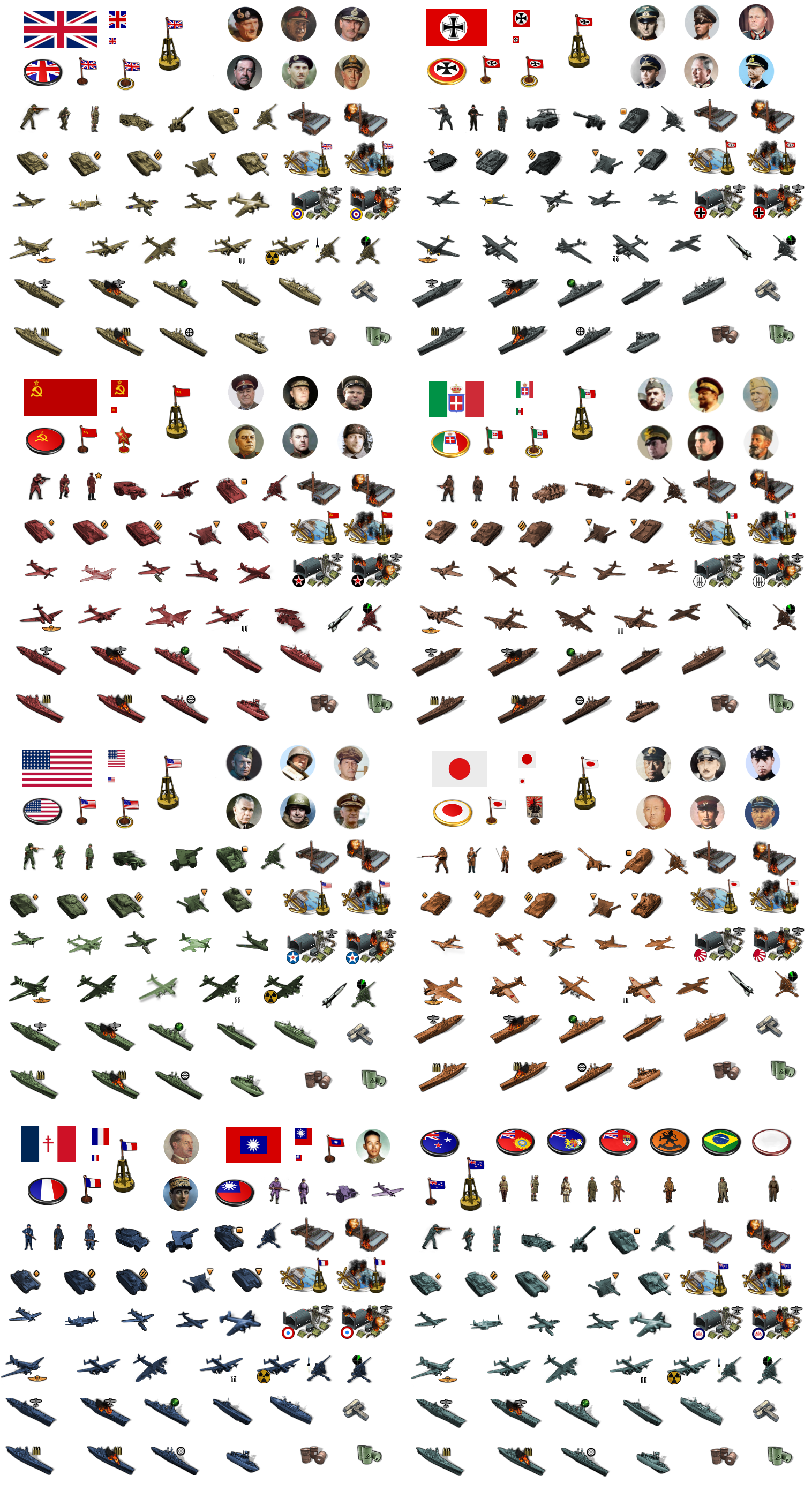
OK, I hit my stride after Turkey day festivities and managed to bang out the G40 units! hehe
Here they are separated out into the various folders...Global Units 54px Tinted:
https://www.dropbox.com/s/pqkn53r1vzjj467/units.7z?dl=0I've been playing around with them at 75% which seems to do alright with bung's centers. There's a little foregrounding and a few clips in a couple spots, but mostly it works pretty well. There's a bit of redundancy there, I think to allow for the same folder to work for Global and v5 in terms of how some of the tech units are labelled. I nixed all the stuff at 48px that I didn't have ready replacements for, so if you want the old stuff I guess you can just backup or unload it by individual nation into the folders, but this one should work for normal play if you want to check it out in preview.


I included the airbases and harbours and bunkers and whatnot. The extra units for tank types and all that stuff as well. For factories major/minor I did a downscale for the minor of 75% so it'd be noticeably smaller, then a second stack for the industrial tech advance. I used some generic labelling for extra units like tank 1, tank 2, tank 3, infantry 2 etc. Gave China a full roster just for completion, did American equipment there in the purple people eater tint, so we'd have an extra set. I was going to do the Dutch and the various neutrals too put lazed out there, but it's pretty much dialed. We can do alt tints for those later or add more stuff to it as we go along, but least it's a start.
Happy thanksgiving!
-
@black_elk
You have been busy!
Downloaded and stored, thank you for your generous Thanksgiving gift!.
A request, can you put a third chimney stack on these two images?

.
Now is it back to the map? -
No prob! Hope they're fun!
Yeah I guess it's back to maps lol. I think G40 is about ready to roll, so that's encouraging.
For sure, here ya go with a real quick third stack there hehe...


-
Thanks!
-
Right on, let me know if I missed anything. From playing around with the flag display, I think the 12x12 circular roundel is probably best, just given the current limitations for the display sizes there. Going oval would only gives us 12x9px for the smallest size, which is too small in my view, like just not really enough pixels to get the job done. So better to keep it round I'd think.
Most of the standard circular roundels look pretty good in the unit flag display. I gave the Soviets a Red Star for their ABs so that may stand out for now, but I think it gives those ABs some charm.
The only thing I noticed that I really want to fix on the next pass has to do with the Naval Units at flag display size small. The flag always displays on the lower righthand corner of the unit field, so on the right-facing Allied ships, the 12x12 small flags looks like they're sitting on the bows of ships. Basically I want to extend the field for those naval units by like 12px or whatever we can manage, so that the roundel will be more off to the right instead of smacking the Allied naval units on the nose lol.
I think I do prefer the Oval puck roundels for the capital markers the more I sit with them. Just for a little more visual variety in the colors and for the national flare. Like Italy looks nice with that splash of Green and Red I find. I included the Flag Oval roundels as unit images in the folders, because I think it'd be cooler if these were treated like capturable units rather than permanent/fixed map decorations.
Doing them as capturable units the display image could change dynamically when a capital is taken, e.g. Moscow becomes the Iron Cross roundel if taken by Germany, or vice versa, if Berlin falls to show then we get a Sickle and Hammer there or Stars and Stripes, or whatever. Control marker flags would work the same way, basically like it's handled in Iron War. So that when a TT changes hands the control flag changes to the reflect the current "owner." I think that'd be nice.
-
@black_elk said in Proposed Map: Domination 1941:
Moscow becomes the Iron Cross roundel if taken by Germany
H yea ! Love it ! lol
-
@black_elk
I agree 12x12 round roundel is the way to go.Adding +12px to naval units is a nice to have, hold off and lets see if we can persuade a new Dev to add a new feature to the map.properties file to position the flag with coordinates, so not in the corner.
Currently he is working on this (Its not Justins group, but ArieLevental on GitHub)
https://forums.triplea-game.org/topic/3311/student-group-studying-triplea/2?page=1Capturable Capital oval roundels infrastructure units is on the TODO list.
"I think that'd be nice." Yes it would be nice.
-
Sounds good! That'd be cool.
It's a relatively quick fix if they can't pull it off. I think the canvas can go to like at least 96px wide right? Basically Allied ships and Axis bombers are the only units that clip the flag display in the lower right. For display Flags "size large" the roundel graphic is backgrounded, but still reads too large for me. It works better with some roundel designs than others there, depending on the color of the outer ring or whatever, but mostly I think it's not a very useful view at that size. Something like a 18-24px flag roundel would be best I think. Larger to give more visual information at that super tiny scale, but still small enough not to clip too hard into the unit, if it were to remain in the foreground.
The other reason it would be nice to select the flag display location is to avoid overlap with any other symbols included in the unit graphics, like the radar symbol or heavy bomber symbol etc. I'd think it would be nice to center the flag for most units, basically so it looks like it's right below the unit instead of off to one side. I think that would be cleaner and show less overlapping or clipping for the tiny flags.
Like ideally we could just extend the field from 54px tall to 68px tall and stick the flag dead center at the bottom. This would be nice for unit flipping too, since then the small flag wouldn't move position relative to the unit when the image is flipped.
I think a good feature to focus on would be that one - the flip. Something that allows us to dynamically flip units in-game, because that's a feature that the players could really engage with I bet. Like I think if it existed, players would probably use that one all the time.
The coolest would be if we could flip units based on the TT. But even if it was a universal flip for all the units by nation, I can still see that being a lot of fun during gameplay. Some view features are a lot more useful than others, map scaling and unit scaling for example, those are super useful, the other stuff in the view tab is more like set it and forget it based on the preferred view. But a Unit flipper would be hotkey worthy. I think players would dig it.
-
@black_elk BTW I wonder is there any way to make AI handling this sub spawn feature?
I guess if the German subs spawn after the end of German turn, AI can respond but this will probably make these subs doomed to be killed before taking any action.
-
Yeah the sub spawning unit in Iron War would basically just add a sub during the placement phase, but then there were some issues if the facility had already placed it's max units since it was tied to coastal factories. Also that game used a different phase order with purchase after combat, so it fit a bit better there. I think a combat move first phase order is a faster paced and more entertaining. Purchasing after, you can make more straightforward purchasing decisions, so players don't have to spend as much time prognosticating about it, and keep things moving at a steady clip. For G40 I like combat move before purchase, though they still run the combat phase proper after the buy. I guess it's maybe more dramatic that way, like 'oh goodness, let's make the right call here and not goof the buy!' lol But I think purchase/placement last is equally entertaining.
For spawning subs out of just random zones in the Atlantic, you'd want that to happen prior to combat move as like the first phase I guess. That way they can be used in attacks which are fun. Whereas if they just spawn to cause distractions on defense, that seems rather less entertaining hehe.
Reminds me that I never really finished the submariner dude lol. I'll have to add that one to the unit pile when I get a minute. The current _All Units stickers I added to the unit folder shows duplicates for the factories and resources etc that don't really need to be repeated for each nation. I'd like to tighten up the rows, and then do something down at the bottom for all the factories or generic unit graphics like that in one spot. Then add in a set of sculpts for the Neutrals or all the extra flags or rando alt inf dudes or whatever hehe.
-
@black_elk Probably <stepProperty name="resetUnitStateAtStart" value="true"/>
</step> should be put under German combat move. It had worked in my previous map. Idk why it gives me error in this time. -
@black_elk so combat move, combat then purchase, place is how Iron War rolls ?
Yea Ive seen combat move first before. Think it was NWO and that's how they did it. The G40 CM first seems a little different.
I don't think you can trigger it with a map option. ISU kids, we got another feature request lol
Probably hungover from celebrating there basketball win against north carolina last nite lol
Edit
Oh yea NCM before Purchase as well lol -
Haha no doubt!
OK here are the Baselines and the Reliefs for the 4k maps...
Global Baseline
https://www.dropbox.com/s/pcvl7jjpenpld7t/World_War_II_Global 1940 relief 25 opacity.png?dl=0Global Relief
https://www.dropbox.com/s/pcvl7jjpenpld7t/World_War_II_Global 1940 relief 25 opacity.png?dl=0Domination Baseline
https://www.dropbox.com/s/khxkql58g73q1n3/Domination_1940_baseline.png?dl=0Domination Relief
https://www.dropbox.com/s/x1qei5rhc137hip/Domination_1940 relief 25 opacity.png?dl=0I've posted the terrain map I used at 100% opacity a few times. To create those painted previews I've been pasting my color map at 75% opacity on top of the terrain map at 100% opacity, so here I basically did the exact reverse. The terrain relief windows are at 25% opacity so when they paint over the base colors it will create that same visual look.
I have used the following Hex colors in the map previews thus far... So to recreate that look you'd use those in the map properties and then tripleA should produce an image that looks like the one's I've been posting.
Americans: 026400
ANZAC: 5ba399
British: 9e7035
Chinese: 533c69
Dutch: e77600
French: 0063a5
Germans: 656565
Italians: 6c4513
Japanese: e19521
Mongolians: a13030
Neutral Allies: d9ab6f
Neutral Axis: 6d664e
Neutral True: e7d2b5
Russians: 940000
Ocean: 66ccff
Ice: d2eef4Now we just need someone to do the grunt work of busting it up into tiles and getting the skeleton going so we can start mapping the centers and the like lol. I feel like I've taken it about as far as I can for the stuff I enjoy doing. The nitty gritty of the mapmaking utilities makes my eyes glaze over, but I can add to the unit graphics and such as it gets built out.
-
@black_elk said in Proposed Map: Domination 1941:
Now we just need someone to do the grunt work of busting it up into tiles and getting the skeleton going so,
heh heh I got the time but not the knowledge lol. See if I can figure it out lol
-
Right on! I updated the reliefs just now with a little more noise reduction on the borders. Should make it a bit cleaner when scaling hopefully. We can fine tune that stuff if we want. I tried to kinda optimize it for displays at 75% and 50% as much as at 100%. It's a bit of a trade off there, cause sharper borders display somewhat cleaner when zoomed out, but softer borders looks better when you're right on top of it at 100%. I went with noise reduction 4 for the lines on these, but maybe 5 or 6 would be better? Kinda hard to say till I see how it displays in-game, but I think this should work to get the ball rolling.
https://www.dropbox.com/s/pcvl7jjpenpld7t/World_War_II_Global 1940 relief 25 opacity.png?dl=0
https://www.dropbox.com/s/x1qei5rhc137hip/Domination_1940 relief 25 opacity.png?dl=0
Let me know how it goes or if there's anything I need to fix lol
Fingers crossed!
TripleA 2.6 has a lot of cool stuff going on already. I think if we get to TripleA 3.0, having a bunch of trick new stuff for the G40 package would definitely be a draw hehe
Hello! It looks like you're interested in this conversation, but you don't have an account yet.
Getting fed up of having to scroll through the same posts each visit? When you register for an account, you'll always come back to exactly where you were before, and choose to be notified of new replies (either via email, or push notification). You'll also be able to save bookmarks and upvote posts to show your appreciation to other community members.
With your input, this post could be even better 💗
Register Login