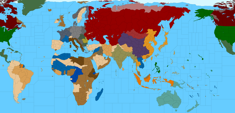
Proposed Map: Domination 1941
-
@black_elk :flexed_biceps:
-
Im really liking the new unit look, that is without the roundels, it looks cleaner and certainly less cluttered so

Here is Ebbes idea from our The Shogun Advanced, you might be able to squeeze a 2x2 unit dashed outline, (120x120px ish) for Gibraltar and Malta. The dashed outline could apply to any island chain.
.
Here are real world flying distances found using
https://www.distancecalculator.net/From To km miles New York in USA to Murmansk in Russia 6456 4012 New York in USA to Liverpool in UK 5325 3309 Natal in Brazil to Dakar in Sengal 3005 1867 Puerto Williams in Argentina to Cape Town in South Africa 6746 4192 Cape Town in South Africa to Perth in Australia 8697 5404 Tokyo in Japan to San Francisco in USA 8266 5136 Brisbane in Australia to Puerto Williams in Argentina 10067 6255These might help/hinder your SZ jigsaw

-
@thedog said in Proposed Map: Domination 1941:
From To km miles
New York in USA to Murmansk in Russia 6456 4012I think Slim Pickens took a different route lol
Good Stuff
-
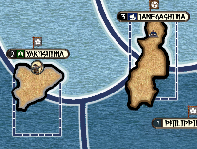
Yeah sz18 is super obnoxious lol. Just the fact that the Guam sz has to touch the Ryukyu sz without making it too small. Like you'd really prefer the useful sz to be larger instead of having their space eaten up by a transit sz. The Fiji sz is fairly annoying too, just how it has to touch Line Is sz.
When loading up Bung's Global map had to recall that sz66 where the "Bung and Veqryn Fighter graphic displays is actually on the far lefthand of the baseline, since the map split makes it seem like it's on the bottom right when it wraps the two edges together lol.
Anyway while I was tooling around down there I realized that Hepps must have morphed China at some point in the 1914 game, probably to fit more zone around Port Arthur or the many Shanghai spots. It created a contour that was rather less round, so I went back in a doctored that coastline up a bit. I managed to get a little more space in some of the zones that seemed more important. At some point it's probably simpler to just start moving the Islands if people want more space, but I was trying not to break too much as I went.
Didn't get as far as I'd planned on account of that, still haven't revistied the Atlantic yet, but this is where I'm at right now hehe

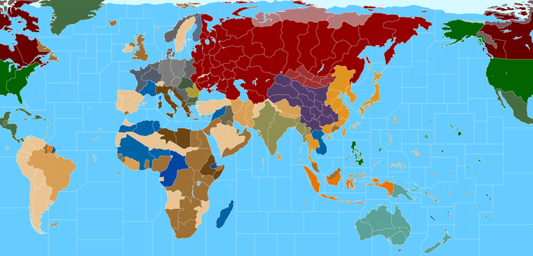
ps. Just for comparison, this is what our players are using right now for G40...
And here's an image of the physical board... I'd say Bung did a pretty alright job for fidelity there, but we're shooting for something with a bit less distortion. Still, it gives a sense for how the TT/SZ sizes measure up on the relative scale.
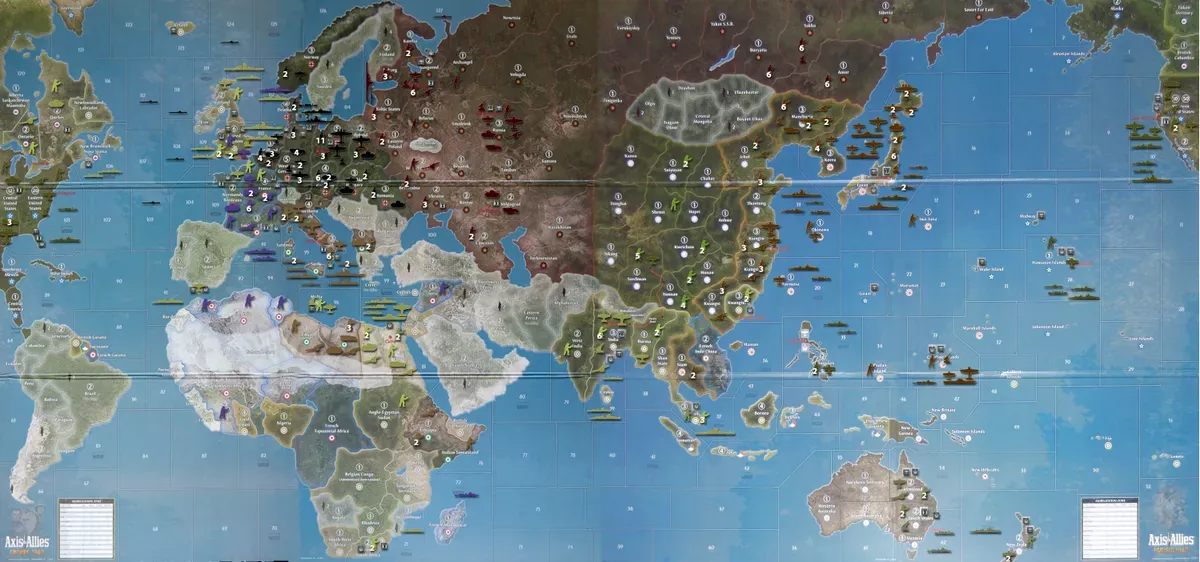
So anyway, I need to go back in and make some corrections for the G40 split. But I'd say we've definitely made some progress.
-
@black_elk :beaming_face_with_smiling_eyes: :flexed_biceps: :smiling_face_with_sunglasses:
-
Alright I took another crack at the Atlantic.
I couldn't see any real advantage to preserving the OOB geometry of some of the shapes, especially where in most cases it would just serve to pointlessly enlarge the transit tiles at the expense of the more important coastal tiles.
My logic there was that it really doesn't make a whole lot of sense to have a bunch of massive rectangular tiles in the middle of the oceans, when the reality is that the player will only ever be passing through them for like 2 seconds during a movement phase right? At least in G40 terms. I tried to prioritize the coastal tiles whenever possible. So the places where the ships will actually end up, and be stacking to the ceiling, I tried to make those spots larger. That was the rationale anyway. We can revisit it if it looks too different from OOB for you guys, but in a lot of instances I find the OOB sz shapes not particularly interesting visually, and not particularly useful given the mechanics at play, so I kinda just went with my gut on that stuff.
-
@black_elk I Dig It
")
-
@black_elk Unfortunately for the eyes, Borneo is one and British in the game (even though it was mostly Dutch in reality).
-
@cernel This is an interesting dilemma that I've been wondering about. So there are a number of Territories in Global that are either not depicted at all, or else depicted but assigned to the wrong faction for the start date.
I felt OK about assigning Sierra Leone to the British cause at least I got a reply from Larry confirming that that one was an error, a couple years back, but then there are quite a few other spots like Sarawak, Honduras, the Falklands, or the various British possessions in the Gulf etc that are simply folded into TTs controlled by another faction.
Then there are of course a number of territories assigned to US control in G40, that would seem to be more like a 'sphere of influence', for spots that came under the American Aegis during lend lease or after their actual entry into the conflict, or even a bit later in the timeline. These can also be a bit inconsistent depending on the spot.
My thought would be perhaps to leave these tiles in tact but to remove their connections in the xml and then assign ownership based on some neighboring tile that does exist and G40 and might make sense?
So for example, perhaps Dutch Borneo could be assigned to Celebs? Since the connections would be removed it wouldn't effect the gameplay, just how the ownership is displayed, until Celebs is conquered in that case. Or like same deal for Honduras or Jamaica (which don't exist in G40) these might be attached to British Guinea (which does). Or like maybe Bermuda gets attached to Newfoundland (which I just realized now is not drawn correctly, not sure how that happened lol). Anyhow, not certain if that works for people. It might be too confusing with a land border I guess.
The alternative would just be to get merciless with the eraser when making the G40 version I guess, which might be simpler, though I found it hard to justify removing some stuff at this point. You know like why have a map that shows Line Islands but not Sakhalin, when the later is definitely visible from space and the former definitely isn't? heheh
Anyhow not sure of the best solution for that stuff, but I figured I could figure it out once all the rest of it was dialed lol
ps. Here it is with Labrador drawn correctly. Must have got switched up in that 1914 map. I raised Greenland a bit so Labrador sz could be larger. Went back to light blue. All the black line sz subdivisions were just kinda ballpark right now. I'm not certain what people are interested in for the larger map, other than making Japan and W. USA 7 moves apart like Kurt requested. Not sure how you guys want to handle the Atlantic, I guess let me know and we can start tooling around with those.

-
@Black_Elk
Just the white SZ and Ships move 2, this is kinder to the AI and AI time taken to calculate moves.
There are plenty of SZ for hide subs in.
Aircraft do move further over SZ, but that is the trade off.
or
White SZ and Black SZ, ships move 3, AI takes longer to move.So I vote for just white SZ and Ships move 2.
Thoughts?
-
I think it's certainly possible to do M2 ships with more SZ divisions, depending on how one wants to handle the starting forces and the production. For example, in the Pacific, if the USA has to mobilize everything out of W. USA then M2 is a big nerf with more SZ divisions, but if they can produce units out of Hawaii then the nerf is less extreme. Or like same deal with the opening round. If the playpattern is like virtually every A&A game where the Allies have a bunch of units that just get destroyed immediately and have to be replaced, then M2 with more divisions is pretty rough. On the other hand if their starting forces are more forward and aren't just getting wiped by the Axis on G1/J1, then you can create a playpattern that doesn't have the Allies stalling out quite as hard. Since the white lines are just G40, even there the playscale recommends some form of M3 I'd think, since G40 has those naval bases and such. Iron War has a map that is about as divided as G40, but uses an M2 Classic/Revised playscale, but it works alright because of the way the starting forces are distributed. Hard to say what's best. I think M3 whether standard or from naval bases is one of those things that can be hard to get the head around if you're very used to say Classic or 1942.2. One of the things that M3 does is kinda mess with naval pickets. It's hard to set up a DD block, if the opponent can just do an end around heheh. I think the map above could probably work using the standard v3 rules, provided it had a new unit set up that accounted for the extra spaces. I agree though, since my thought would be to make something that is compatible for AI solo play, anything that's going to make that drag should probably be avoided when possible
")
Here is it is showing the all blacks for comparison
-
Yeah, you make some good points, even more reason for white SZ with ships M2.
-
I can't get over how just changing the border lines from white to black makes the exact same shade of blue for the oceans appear to be a different color, just from that alone. Such a trip! Our perception of color is so strange heheh. It's all relative I guess
-
So regarding the SZ subdivisions (black lines), I'm not entirely sure what the ultimate goal is there so I'd probably back burner it till we get some thoughts just so I'm not laying down a bunch of lines that need to be instantly erased lol.
Like I can imagine more dynamism for island hoping when more of the islands straddle a line, because that makes the TT more useful for projecting power with aircraft. Effectively an island on a line becomes an air base without really necessitating an 'air base' unit per se. So that sorta makes sense to me.
It's tricky to know what sort of general Naval dynamic one wants to entertain though. Like A&A doesn't really do a great job of simulating naval warfare, and it's generally subordinated to the ground game for simplicity. Unless you want the sz tiles to somehow get ships with different movement rates and abstract it that way maybe? In Iron War you got the PT boat at Move 1 and the cheapest cost, which turns it into basically a fodder wall. It's kind of a weird unit to highlight for such an important role mechanically, but I guess like Kennedy or whatever, it's got some charm to it.
I can imagine a scheme where Carriers are M2, but the rest of the surface ships are M3, which might create a situation where you get some kinda staged back and forth trying to dance the carriers into position, while projecting the fighter aircraft and the destroyers and cruisers and whatnot. Or another way would be to have the carriers and battleships at M1, and everything else at M2, though I think many A&A players would revolt at that idea lol.
I was just trying to imagine something like Medieval Total War, where the goal in the naval game was to create a series of connected sea zones, to increase trade and transport armies. Connected Empire in Risk more or less, but on the water. You know so that rather than just needing to preserve your massive armada stack in a single tile, the player has a reason to divide and try to hold more Sea Zones at once. That is very different from standard A&A play though, and probably requires like a complete reimagining of everything about the naval game. Kinda ambitious.
I honestly think you could have a pretty fun AI type game, just using the regular rules and unit interactions for the most part, and just make it simpler to move production fronts. Basically allowing players to place "Factories" in many more locations as the game progresses. In A&A you can't do this unless a TT is worth enough to make it possible and there are always rules about where they can go, but I kinda like the dynamic that allows the players to push their warfronts that way, even if it's super abstract and gamey. Forward Bases or deployment points, rather than 'factories' if that makes sense. Cause if you can drop one of those on an island chain after advancing, you can sorta build on the momentum of a press.
When it comes to divisions in places like say the North Pacific, I'm less confident about how to do this, if only because having a ton of tiles separating Japan and the USA would seem to preclude any endgame where Japan tries to threaten the USA directly. Gamey while that might be, it's still an alright goal I think, of a good A&A style game, to give Japan the option of putting pressure on the W. USA, like if the Americans are ignoring them to focus on Germany and the Atlantic. So the further away you push Alaska the less likely likely that becomes. For an AI style game where the player is basically just beating up on the computer cause they want to paint the world their colors, I'd think allowing for warfronts in the Americas would be a good thing. Same deal with Japan fighting the USSR. Sure we could take it off the table entirely, but then you definitely limit where that kind of game can go. Rather than a NAP, I prefer I situation where the USSR can fight and win a landwar in Siberia vs Japan rather than simply folding like they do in the Classic dynamic. But the challenge is always sorta the same, give the Allies too much and KJF crushes, give them too little and Japan runs the board. I think what I'd like to see is tiered projection centers, like lily pads, so the Soviets have fallback positions if the IJA gets it's way and a landwar into Siberia is initiated.
The thing that prevents the USSR from just rolling up Japan, should be more the coastal transport advantage. But you'd almost want a situation similar to how France works in Europe, like under the Classic Dynamic where Germany can basically eject the Allies trading out of their main tile. So in the Soviets vs Japanese invasion context, if Japan lands a gang of units in Amur or the Soviet Far East, that the Soviets could clap back and turn the coastal tiles into deadzones that are traded, rather than just ceding those TTs instantly cause they are too economically weak and lack any production to reinforce them. I feel like a potential landwar in the Americas should be similar, you know where Japan might grab a toehold in Hawaii or Alaska, and perhaps advance on the West Coast, but then giving the Americans or Canadians ways to clap back.
I don't know though, my thoughts are kinda all over the place on what sort of map to make. I really enjoyed Iron War, and I'd almost like to see something along those lines, but just with a bit less going on in terms of Resource Management and the sheer number of factions. I thought D10 and the advanced roster was fun, but it might be a bit much. The old Big World map I think had a nice approach, which was essentially A&A Revised, but bigger lol. I think one could probably do something similar and have that be pretty entertaining. Like Ozteas G41, but just with a few more things going on, and a new map that looks pretty heheh.
I don't know, I'll let you guys figure it out I guess.
What I'd like to do now, is lock in those G40 divisions, which means repainting from the 2 color bitmap to make sure I didn't break any lines while redrawing (which I always seem to) so I'll bang that out with the simplified G40 ownership just so it's easier to compare to OOB and catch any mistakes. I'll give it a shot tomorrow
ps. @Cernel how do you feel about the handling for those G40 tiles corresponding to W. Germany and Greater Southern Germany? My thought was that it kinda made sense just for the shape of the G40 TTs. Where I guess the 'Greater Southern' part just means like Austria sans Tyrol heheh.
I thought about including Bohemia in the tile, but then there's the G40 need for E. Germany to touch the Hungary-Slovakia tile. It might work if more of the Czech tile was carved into but then you kinda lose the recognizable shape for Czechoslovakia, which maybe might be worth keeping just for game set more in the late 1930s? I don't know, but I guess it's kinda similar to the Axis Balkans or Yugoslavia conundrum. Like trying to give a shape that works for a couple possible start dates, but that doesn't break the basic G40 look too hard lol. I don't know if there's anything that stands out too weird let me know. I guess for stuff like Dutch Borneo we just paint everything to look like the OOB board. Like basically everything in the Western Hemisphere is getting that drab almost USA green, even if it was a British colony or whatever. Probably simplest I guess, still I kinda liked the idea of showing the British Empire in full. I feel like a cool theme for a WW2 game is sorta the preamble to dissolution of the Empire. Like just the way G40 has them busted up into 3 factions as a nerf. On the other hand, I also like the idea of the British globe trotting, which having more of those tiny zones represented might be fun. So it's sort like you got the crown running stuff out of Labrador and Newfoundland, but the Canadians are doing the heavy lifting out of that zone. Or similarly in the Pacific early on the Brits are scrambling around Malaya or Solomon Is and trying to hold the lines, until India and Anzac can show up, where then they fall into the support position. So basically UK still sorta everywhere like in the old games, but not as pronounced. Basically treating the those regional dominions like a separate faction but just grouped into the same turn block?
-
@black_elk said in Proposed Map: Domination 1941:
ps. @Cernel how do you feel about the handling for those G40 tiles corresponding to W. Germany and Greater Southern Germany? My thought was that it kinda made sense just for the shape of the G40 TTs. Where I guess the 'Greater Southern' part just means like Austria sans Tyrol heheh.
I thought about including Bohemia in the tile, but then there's the G40 need for E. Germany to touch the Hungary-Slovakia tile. It might work if more of the Czech tile was carved into but then you kinda lose the recognizable shape for Czechoslovakia, which maybe might be worth keeping just for game set more in the late 1930s?
I tend to think that I would include Czechia (which, at the time, was the sum of the Sudetenland and Bohemia-Moravia) in "Greater Southern Germany" (even though it should be rather called "Southern Great Germany" or, better, "South-Eastern Great Germany"). Fix the adjacency by actually re-drawing the borders as to assure Silesia and Slovakia are adjacent as they actually were after the annexation of Katowice to Upper Silesia. This means giving that south-west corner of the "Poland" territory to the "Germany" territory. It looks like "Poland" is only representing the General Government zone plus the enlarged East Prussia, so this change should better capture Germany as to be all the metropolitan German territory after the occupation and partial annexation of Poland. My best guess is that "Greater Southern Germany" is actually meant to be mostly Austria plus Czechia otherwise why not having called it just "Eastern Austria"?
You can make Albania realistically bigger, by the way, by giving it what was annexed to Albania after the conquest of Yugoslavia: it makes no sense for Albania to have those territories in a 1940 game but, in a properly drawn 1940 game, Albania would not be adjacent to Bulgaria, either. After all, the territories annexed to Albania were populated mostly by Albanians and the territories annexed to Bulgaria were populated mostly by Macedonian Bulgars (currently known as North Macedonians).
-
Right on, we can give it another pass after I move into the next phase, which is something a bit like this...
With the G40 tiles roughly blocked in, we bring up the a terrain map and contort it to roughly graft onto the baseline, just to reinforce what's going on and sell the distortions in an impressionistic way.
This is the part where we literally move the mountains and redirect the course of the rivers like Thales
Basically so the terrain can adapt to the overall game warp. I'll go back in a redraw some borders or repaint some terrain, knock it into the background a bit so it's not a focal point and just try to get the major rivers and lakes around about where they need to be to make it 'feel' alright.
Once that's done there a lot of ways to do a decorative paint job, but the simplest is just to do a gradient where the opacity goes from 100% whatever the HEX color of the player nations to fully transparent across say 50-100px. That's usually enough to let enough of the terrain background peek through so it has that vibe, while also being easy enough to tell who owns what by the border lines. In game it would just be a value gradient sands hue/sat, with that info provided by the map properties. But to paint it up manually basically you can magic wand a tile window and do it that way.
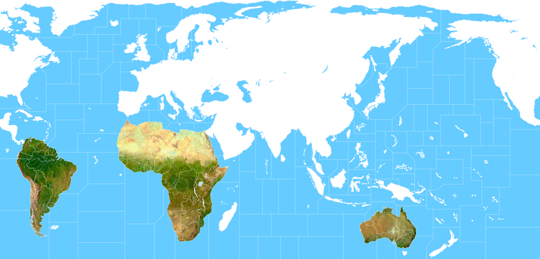
Here it is start to fill out in the Global south, since they kinda get short shrift in scale, figured I'd start there cause it's a bit easier with the separate landmasses. Basically we'll just be going around the board like this and blocking it in region by region, until it looks cool enough to pass muster. Then stitch it all back together once we got more of those features in place. Easier to recast the TTs at that point so it all sort of agrees, since people will scrutinize Europe a fair bit I'd think. Still we can fudge it a bit by increasing the opacity of the transparency and background the terrain more than this. Just wanted to show what the step looks like. When we finish we can save out a couple images/layers. The Baselines, The terrain, the Labels, and then the decorations.
Anyhow, this is crude cause I just sorta slammed em in place, but you get the idea. We'll comb over it with the clone stamp and the paint brushes to create a basic template, then go back in and doll it up once all that stuff feels good.
-
@black_elk said in Proposed Map: Domination 1941:
It's tricky to know what sort of general Naval dynamic one wants to entertain though. Like A&A doesn't really do a great job of simulating naval warfare, and it's generally subordinated to the ground game for simplicity.
As each SZ has a PU value Im hoping the pacific will be become hunt the submarine, as they take SZ/PU the enemy will have to send out destroyers to kill the subs or reclaim the SZ/PU.
As well as the island hopping battles.
-
@thedog more blockade zones help as well. One thing that is hard is to prevent is the two big fleets facing off. The PU value can be such a drastic change, that it's usually not worth the risk of a bad first round of rolls.
Maybe with farther to travel and multiple high valuable areas to defend could help also. Haven't been able to try that yet, ( I guess you could with reduced movement but I think it slows the game too much ) this new map should make it possible.
-
more blockade zones help as well
Totally agree, in test game ships have a Blockade of 1 and Subs have 2.
-
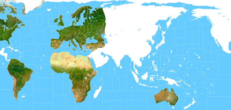
Just chipping away at the terrain. I'm about halfway finished with the blocking, but just to give an idea. You can see the method is basically a combination between adjusting the morph of the terrain to suit the drawing, then adjusting the borders of drawing to follow the terrain, and back and forth like that lol. I think for the final pass it will mostly be about omitting or knocking stuff back so it's more subdued.
Since in gameplay the focus will be on the units, it's more about just creating a sense or impression of reality rather than the real real deal if that makes sense. So like if the player can see the mountains and rivers and it feels believable, then the distortions of the warp itself become less pronounced. Sorta the inverse of what one might usually do. This whole approach is a bit ass backwards, but it's sort what is required to get a map that can work for the basic G40 abstractions. So you know instead of tracing the world to make the map, here we are making the world fit our drawing, sorta like they did for the all more modern A&A maps, but just with a new spin to get that vibe going as well hehe. I'll be repainting some of the rivers and such to get it aces once it's all in place. I think looks pretty cool like this, all bare bones, but obviously we'll get it going with some colored borders and such once II'm back on that again hehe.
Anyhow, here's where I'm at with it tonight...
Although I've been making the baseline map at 16000px I think for G40 it will look a lot better at like 13000px with the relief, maybe even down to like 11-12000px because that looks pretty solid with 54px units at 100%.
Hello! It looks like you're interested in this conversation, but you don't have an account yet.
Getting fed up of having to scroll through the same posts each visit? When you register for an account, you'll always come back to exactly where you were before, and choose to be notified of new replies (either via email, or push notification). You'll also be able to save bookmarks and upvote posts to show your appreciation to other community members.
With your input, this post could be even better 💗
Register Login