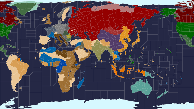
Proposed Map: Domination 1941
-
@black_elk that's why this map is so badass. it can do multiple things lol
Edit
Ah yea can still hit Malta in 3. Wouldn't want me for a navigator lol -
I wonder, just since we've been kicking around ideas about the range on aircraft, and since the G40 templet assumed Air Bases or Naval Bases giving at least a +1.
What if we instead went with something rather simple. Like units can just get +1 (ships) or +2 (aircraft) but only on Non Combat movement? That would preserve the ability to transit units for reinforcement purposes, though not necessarily for running attacks. Seems simpler to me that having a gang of bases everywhere.
Here it is with dark oceans, just to make those sz borders a bit easier to see.
-
@black_elk yea you'd have to player enforce though. I can't think of a way to do it splitting between CM and NCM. Maybe it'd be a fairly easy feature request ?
One of the ISU guys might take it on
") Probably not
Probably noti know you said the bases make it more complex, but I also found those A0C5 Bmbrs like more targets lol
-
@black_elk cool
That water looks cold :grinning_face_with_smiling_eyes: -
hehe it's funny, because the reality is that we don't perceive color in isolation, only in relation to the surrounding colors.
So simply by changing the ocean to a dark blue, the value of the others colors appears to change, even though they haven't (well except for Japan's mustard.) Just kinda one of those curious quirks of the color palette and whatever the overall read in value is going to be lol.

You can see the knock on color effect when I put em right next to each other hehe.

Yeah might be too hard to pull off the CM/NC thing for air. I guess I'm not opposed to Air bases on general principle, but it'd be nice if we could figure out something that's flexible and not too tricky. Might be a tall order lol
-
another thing that makes it more complex but from redesign ideas, is the base is required to build air or naval with capital ships and Bmbrs only built at home Factories
makes em a lot more important then
9) "FactoryLimited_ChangerMustActivate"
Air and Naval Bases now cost 12. All captured and newly constructed Minor Factories may only produce Artillery, AAguns, Armor, Mech Infantry, Mobile Infantry, Marines, Elite and Infantry. If a NB is present you may also build Subs, Transports, Escort Carriers and Destroyers. If an AB is present you may also build Fighters and Tac Bombers.
ABs are required to build Fighters, Tac Bombers, Bombers and Air Transports. Bombers and Air Transports may only be built in Factories on originally owned Territories that also have an AB. In addition, Bombers and Air Transports may not be built in the following territories: Kwangtung, Egypt, Norway, Alaska, West India and Korea. May not build at an AB with 3 or more damage.
Note: You may not place new Fighters on CVs. All air units may only be placed in the Territory that contains an AB as well as the correct Factory.
NBs are required to build all Naval Units. BBs, CVs and CAs may only be built in Territories with originally owned starting Factories. These Territories must also have a NB (Need not be original NB). May not build at a NB with 3 or more damage.
New Zealand receives a Minor Factory to allow ANZAC Air builds. Quebec receives a NB to allow for Naval builds. The Central United States receives a NB to allow for additional prewar Naval builds.
This addresses Capital Ships and Bombers being built in newly conquered Territories. It should also be noted that UK may only build Air Units in UK at game start. This makes the UK AB a prime Axis target. -
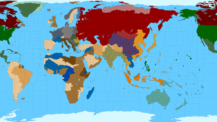
@Black_Elk I'm just gonna look at the map for a while
Think I'll make it my screensaver :grinning_face_with_sweat: :grinning_face_with_sweat: :grinning_face_with_sweat: -
haha right on!
The main reason I like to switch borders from white to black, or sz from light blue to dark blue and vice versa back and forth, is so that I can catch floating pixels and weirdness like that. Which tend to pop and jump out if I can isolate and then change the value of the colors for the switcheroo. So it's kinda utilitarian in that way I guess, but also makes for a kinda cool variety in design. Just depending on what people like for a look with their maps.
-
@Black_Elk
This might help map making, currently in game;
Move
8 = 4 engined strategic bombers
4 = 1 or 2 engined dive/tactical bombers
3/4 = FightersFactories have their own AA and Air defence of 2 in 6 AA built in, players can add more AA or Fighter units.
Factories also have rail links built in, and all ground units have a total move of 3, Infantry move 3, Light Tank moves 3 when starting on a factory
Ships will probably move 3 on the big map.
I am trying not to give any pluses to movement for shipyards or airfields only rail links, but testing might prove otherwise.
-
Sounds good. Here I blocked in some quick provinces for Spain and Sweden, Turkey and Iran and whatnot. I must have erased those when I was making the Global 1940 baseline from it. Anyway added some divisions back in just so those spots wouldn't look weird compared to the others heheh.
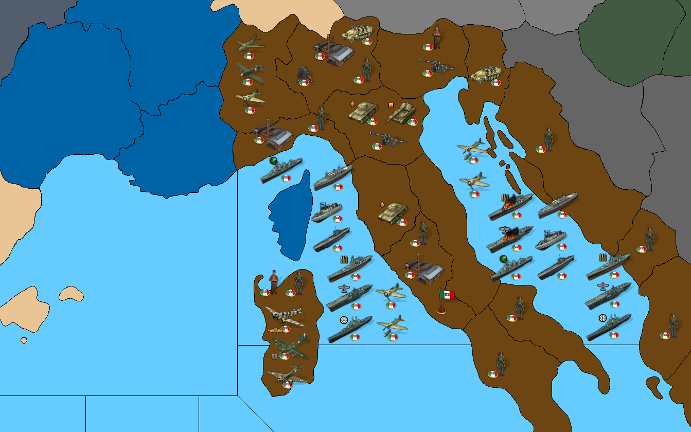
I added back in some provinces to Italy as well. We can revert to the defensive lines and the blocking of the previous draft if desired, but I just wanted to save one out that was a bit more carved up, for future reference.
Basically (going off the divisions below) we want everything in the north of Italy, Piedmont, Milan, Genoa, Venetia, Istria etc as a single tile right? like Cernel suggested. Then Tuscany Rome, and the Marche-Abruzzo space together as a single tile. Then the stuff at the bottom of the boot as a single tile. So basically 3 main territories in Italy, with the one the very top being the most important strategically. So having that TT be the fall back zone. Also for the fleet fallback, like either to Genoa sz or the Venice sz, when they start getting rolled up on by the Allies. Basically they should be dropping their new ships out of that northernmost tile, which would border both the Adriatic sz and the Ligurian sz. That makes sense to me, even if Rome and Sardinia are like the prestige tiles, the core should be up there in the Milan tile where the Industry was. A scenario set earlier, like WW1 or a pre-Unification era or whatever, could use the baseline draft that has Italy more busted up. But for WW2 we just collapse the smaller tiles into larger ones. I'd like to do the same tomorrow for Germany and clean those up a bit.

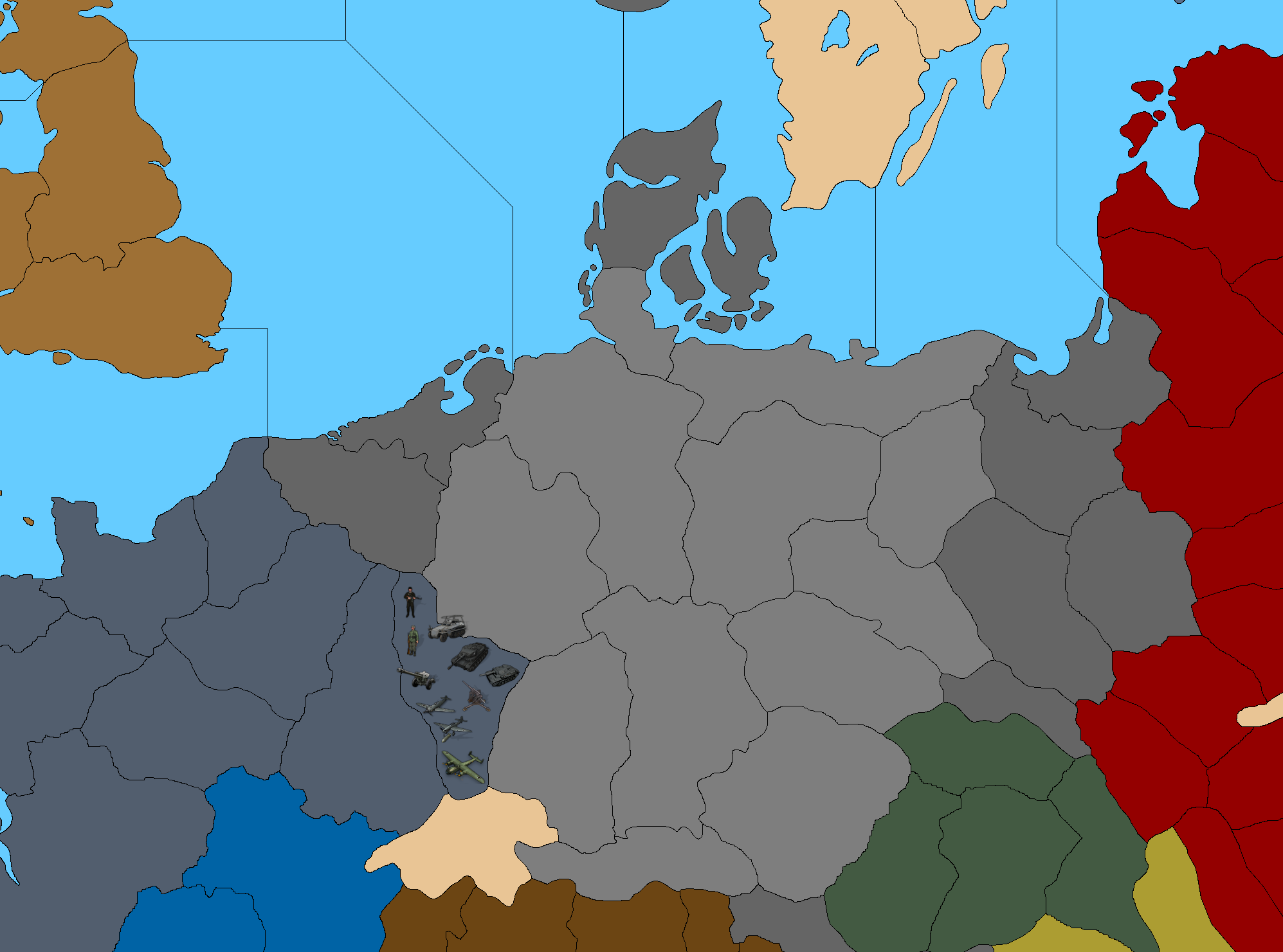
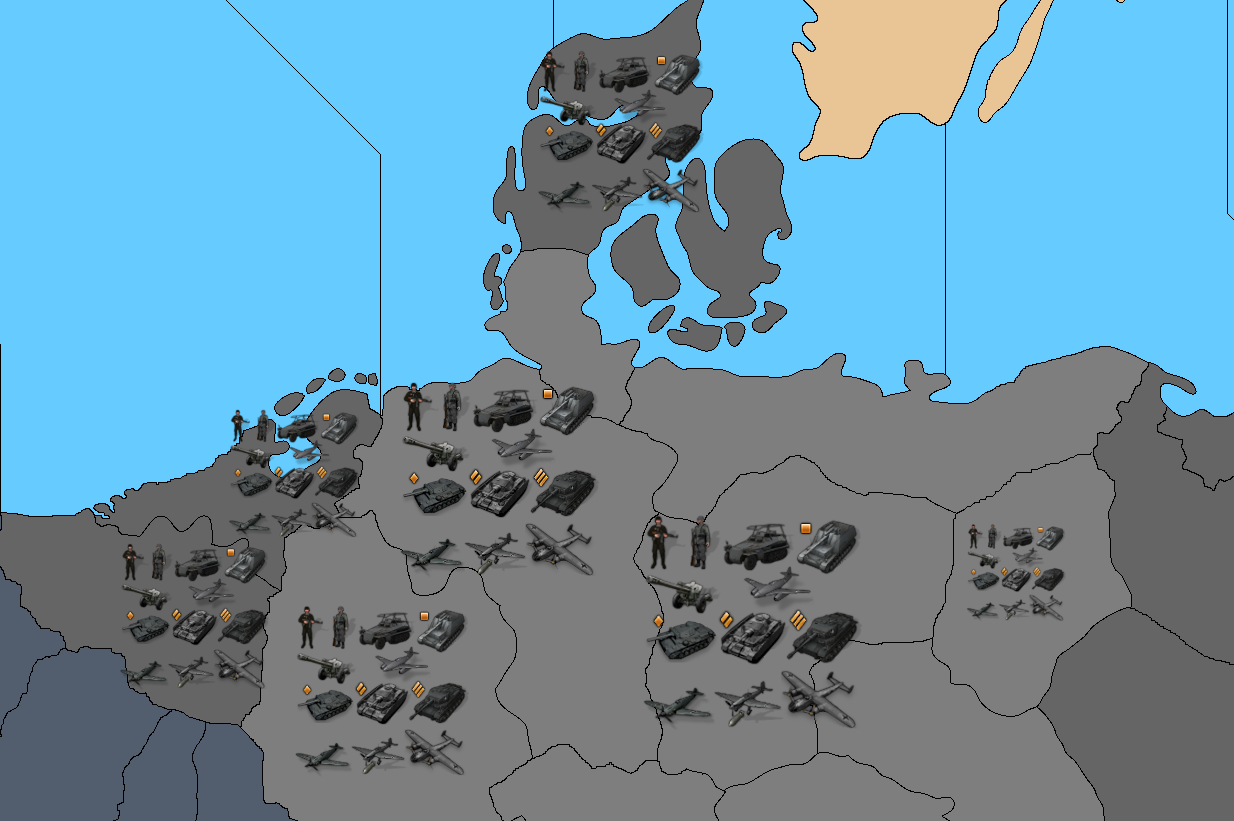
Here is a detail showing some units on Italy...
I just randomly slapped them down to give a sense of relative scale.
You can see there should be plenty of room if we group those TTs together.
I think we could probably fit 24 almost 30 units pretty comfortably into the larger TT ( the one comprising everything north of the Gothic Line), before the sculpts start spilling over.
Ships take up a little more room, since many are fairly wide at like 92px I think, but with some nice center seems like there'd be plenty of space to get the job done.
-
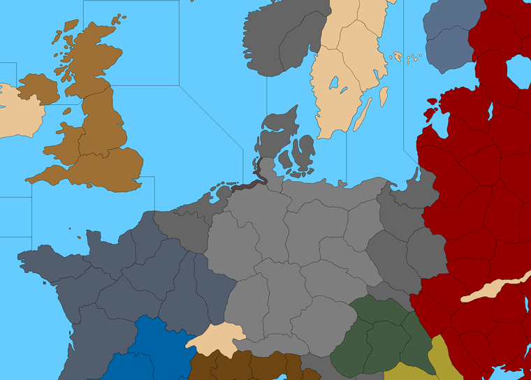
Here is an idea for how to handle Germany...

https://www.dropbox.com/s/qc3xgrbtqp55gt6/TripleA_4k_Domination_1941_draft_1px_borders.png?dl=0
The coastline TT on Holstein/Saxony would allow for aircraft to pass over, or for ships to be produced into the adjacent SZ, but would prevent amphibious landings from occurring across that divide.
By doing this we can make the final defense in central Europe a lot more interesting than what we typically get in A&A.
So instead of the Anglo-Americans just dead-dropping straight into Germany by sea, this way we can create a more interesting/staged dynamic.
We could use a similar coastline in a few other spots so it's becomes a slightly more familiar feature instead of just a 1 off, but I think this space right here would be it's best use. This will allow the Germany player to deploy their forces in a way that makes sense for the battle in France and such, rather than just having to stack in Saxony to hold off invasion by sea.
Seemed a good idea. Like the Dog mentioned at the start about trying to use coastlines as a feature, and what Cernel said, this way the bombers can reach the spots they need to more easily.
Let me know if something more like that works for you guys.
-
@black_elk I see no problem the possibilty of amphibious invasion of Lower Saxony by the Allies. Lower Saxony was part of Atlantic wall and one of the possible target.
OTOH Amphibious landings are too easy in TripleA compared to real amphibious operations. Maybe you could make transports a lot more expensive or add coastal batteries.
-
Yeah I mean it just depends what you want the game to model, and how complex you want it to be, or how far you're willing to let it to depart from the more traditional A&A unit interactions and gameplay expectations.
One approach is to add a new unit type like a bunker/coastal fortification, or naval mines. Or to change how transports work, how much they cost or how amphibious invasions work mechanically, according to rules. I've seen games that try that approach, but they are also fairly involved. Changing anything with transports has a lot of knock-on effects for example.
I was instead trying to show a map design type solution, which might be more expedient if one didn't want to change any of the above, but simply to avoid a common if somewhat undesirable gameplay dynamic in many A&A games for this area specifically. You know, the one that has the Allies doing the double hit amphibious landing directly into Germany, while bypassing the whole D-Day into France thing lol. Having the German 'capital' not set in a coastal TT makes the traditional Allied amphib attack plan in A&A somewhat less effective for the couple de grace by sea type maneuver, but you'd still see something similar with the positioning on W. Germany dynamic I think.
Just an idea, but perhaps not winner? Lol
I see this issue with the amphib dead drop vs G in A&A being somewhat similar to the Russia/Japan NAP, or the rush by Japanese tanks across Western China towards Moscow via the center route situation. You know, where the typical gameplay dynamic pushes the playpattern in a direction that doesn't quite mesh with common expectations of how a WW2 playpattern 'ought' to unfold hehe.
Seems like a place where map design might produce a more straightforward albiet somewhat overly simplistic solution hehe. But again, just a thought. You could represent the same with a decorative map icon rather than an inserted tile. I was just trying to find something that might work and be easy to parse at a glance, without being too visually jarring.
Here it is again, but with that idea nixed...
Some of these TTs in Europe are quite tight already. I mean it's definitely more spacious than NML, but even with the much enlarged map, I think you'd probably have to do units/centers at like 75%-85% max, or it will be pretty tricky to fit 9 without having a fair bit of spillover occur like everywhere in Europe lol. If one of those 9 units has to be a fortification unit, the spillover happens a bit faster. Saxony is pretty large though, I'm sure you could fit a fortification unit or graphic there. Some of these smaller tiles were just for my reference and can be beefed up, but I was just going by the hard and fast rule, that the more important TTs need to fit 9. So Alsace would be about as small as I'd want to go for a tile that has to do heavy lifting.
My preference would be to not see any black overflow lines with the starting forces/unit set up at the outset. Things that make a map hard to parse or visually unattractive to me during that initial first glance, would be stuff like those black overflow lines. Another thing I find unappealing would be units from different player nations co-located in the same tile at the start, like G40 does in Egypt/France/England, which I think adds to the visual clutter. That's more a starting unit distribution thing I guess, but just something to hold in mind. It should present nicely at first glance, would be my hope.
-
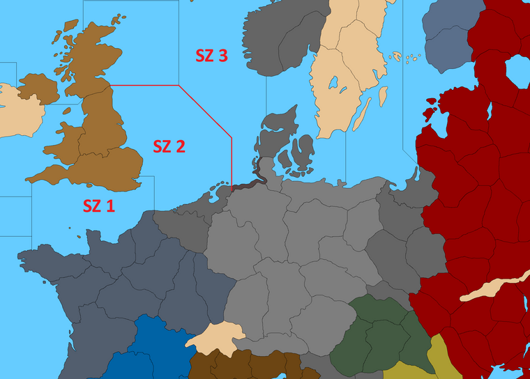
If you draw the sea zones like this, invading the German coast will be already harder than invading France. Because Allies won't be able to reinforce SZ 3 due to lack of nearby factory unlike SZ 1 and SZ 2. Merging Saxony-Schleswig Holstein, Making Rhine way more valuable than London and Paris can even further protect the German coastline.
-
Sounds good! I'll do it like that. Easier solution for the win!
Here is an example showing Alsace with some units. You can fit about 10 I'd say with units at 100% scale, maybe 12 before it starts getting really cramped.
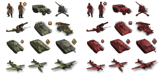
ps. Oh also, I think for Units, we'd want to remove all the national roundels I think right?
They take up a lot of space, like I can make the Infantry unit half as wide without a roundel for example, so removing those would free up more room.
I also find the unit roundels somewhat visually distracting/repetitive. I think we could do units with more of a set tint/hue, and it would probably work better for parsing at a glance, least at this scale.
If one wanted roundels for further clarity, that can be turned on as a map feature, although I admit that doesn't look spectacular compared to the drawn roundel lol. I don't know there. I guess I'd make two sets of the Frostion units, one set with a national tint, and one set with roundels, so we can see which feels best?
-
@black_elk
When I put Bunkers in for Japan,
Japan on turns 7-14 get a Bunker per turn, this is to simulate the start of Japan Island defencesI forgot about the German sea defences for D-Day, so German and maybe all nations should be able to build Bunkers?
For reference Bunkers are 0/3/0, with 2 Hits.
-
@black_elk said in Proposed Map: Domination 1941:
I also find the unit roundels somewhat visually distracting/repetitive.
I too thought of removing the roundels, so it gets my vote. The national tint idea is even better.
If players what a roundel equivalent they can;
View> Flay Display> small
So I would not bother with the Roundel version. -
Right on, that's what I'll do. I need a little break from the map anyway lol.
The upside is that, if a player does want the drawn roundels look, that work is already done. So no skin off our backs right. Easy enough to make that available.
Unfortunately the View> Flay Display> small thing can look pretty rough sometimes, since it's based on the UI Flags, though we could might be able to make those look somewhat more appealing by touching up the Flag graphics.
Here is a quick example of the German units with just a very subtle tint.
We could push it further to make the color value even more uniform, or leave it more subdued like that, with a bit a variation, though still all basically gray/black.
Obviously Germans are pretty easy cause it's just a mater of tweaking Chroma towards Gray. But basically you could do the same with each faction. Usually the alt colors are in the aircraft and infantry, so for that one I just removed the reds and greens, but kept the blues and golds there.
I think the black infantry unit looks a bit cooler myself. Just has a little more dynamism in the pose there, so I'd kinda lean towards making him the default Inf. Though I guess just depends how elite you need your elite to look I guess lol. The other guy gives off a bit of a paratrooper vibe to me, so I think he could work like that as a sort of catch all? Or I could do an upscaled version of the current G40 German infantry unit and just detail him out a little to fit this unit set better.
We could make the units appear more black or more blue/gray, whatever seems best there. Though I think as long as they are in the same range in terms of Hue, we can get a little variety going for the value. You can see that the fighter aircraft without a roundel don't have to be quite as tall. I mean really, anywhere we can shave off half a dozen pixels is going to help right? hehe
Basically what I'd want to do is go through Frostion's set - remove the drawn on roundels, adjust the tints to be somewhat more consistent, get the crops as close as seems sensible, and then fix the dropshadows so everything looks clean again. Shouldn't take too long I wouldn't think. I'll try to bang it out during the downtime this week.
-
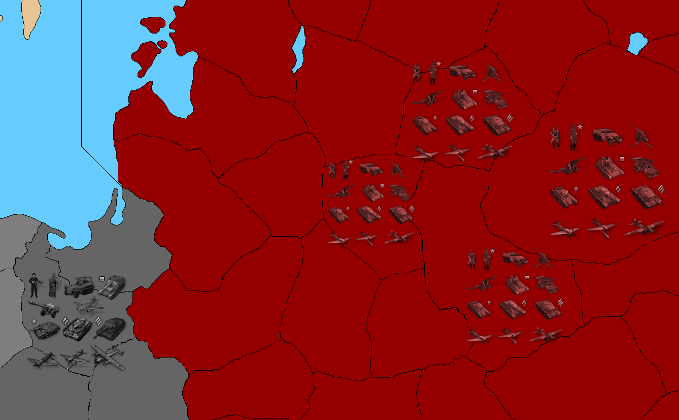
This detail shows those units at a few different scales... Just to give a sense for how it might read for an overall display at those scales.
So that map below is at 100%, but showing the units at 110% Berlin, 100% Saxony, 87.5% Ruhr, 83.5 Denmark, 75% Belgium, 66% Netherlands, 50% Posen
I think much smaller than 75% can be pretty hard to make out, but I like something at 83.5 or 87.7%. Upscaling to 110% or more, would be more like for the global map with the larger TTs I'd guess.
100% will always look cleanest, because you get some blur anytime you scale down or scale up (upscale definitely creates the most blur), but it still looks pretty decent as long as you don't go too large or too small from the starting point. It'd be nice to have enlarged units for the Global game or AA50 at 16000 px, but that entails redrawing/recreating everything. So it'd be easier to just use Frostion's work for now and downscale the baseline for Global or AA50 to something smaller than 16000 px, like say Global at 13000 px or AA50 at 9000px or what ever, just so the units we have available can display somewhat larger for those games if one wanted.
Dynamic center scaling might be a kind of cool feature for TripleA. Has anyone explored that? Like you'd think it might look a little funny, but when you see it laid out it's not half bad.
I mean say you had just a couple thresholds, so it might downscale to the next size lower in a smaller TT that had smaller centers. I don't think you'd want to jump from say 100% all the way down to 50%, but if it just scaled between say 100%-83.5% or 100%-75% dynamically, that might not be too jarring visually. You know, like where if you click into tile and grab a unit, it enlarges to 100% during movement, but could downscale to fit into a tighter spot and still look clean once the movement is completed. I don't know if the engine can do that though? Anyhow, just an idea.
I'd guess we'd just have to pick the smallest unit scale that's still feasible for viewing and ready play, at least for now.
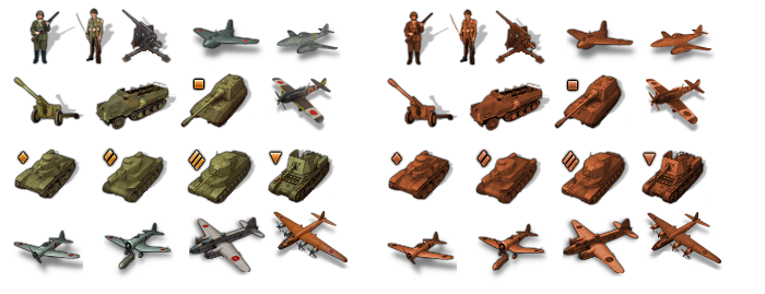
ps. For a more uniform set of tinted units, the simplest method is just to colorize them. So for example taking the soviets from something like this to something like that by just selecting a red. I believe this got added as a feature right? So it could be that we don't even need to do the work on that. Just select some decent HEX colors that pair well with the background TT colors of each player nation.
It's a bit of a blunt instrument, as opposed to individually repainting each unit, but pretty straightforward.
I almost prefer this approach though, because that way I don't have to jack up Frostion's art just to accomplish the goal of making a more uniform hue for the unit sets hehe.
Truer to the source I guess, and also a lot easier to manipulate. So I think we can just do that probably. I just picked a quick red and gray to show the vibe on that, but you can basically do this with any HEX color one might prefer. Usually to make it work you just need to pick something with enough contrast to the background TT color so it reads alright.
Here the vibrancy between TT color and Unit color is pretty close, about as close as one can make it, but in the actual game you'd want a bit more distinction I think. The choice of sz color blue will also effect this, like if you have a dark ocean you'd want lighter ships or vice versa, so it reads better at a glance. This is just the bare bones hehe
Or if you like the Japanese to be more orange say, instead of ochre, for fidelity to the OOB sculpts you can just change the HEX. And it'd be as easy to switch that as it is to switch the TT ownership colors in the map properties. You know so you can change the vibrancy as well as the hue and lightness to match whatever aesthetic you enjoy.
Basically so the player can adjust that stuff if desired without having to jump through too many hoops. That'd be nice. And you can keep the national paint job version for that look, with or without roundel. So kinda trying to get the best of both worlds out of the unit set.
Happy Halloween! lol
-
@black_elk
When you are bored :beaming_face_with_smiling_eyes:Could you give some thought to some new unit icons?
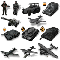
4 Command icons, these give +1 Atk/Def with certain units stacked with them
and a new Bunker, placeholder is this one


There are more, but I dont want you to burn out

Hello! It looks like you're interested in this conversation, but you don't have an account yet.
Getting fed up of having to scroll through the same posts each visit? When you register for an account, you'll always come back to exactly where you were before, and choose to be notified of new replies (either via email, or push notification). You'll also be able to save bookmarks and upvote posts to show your appreciation to other community members.
With your input, this post could be even better 💗
Register Login