Proposed Map: Domination 1941
-
@black_elk Imho Germany in 1940 was almost 3.5 times bigger than the UK.
If the UK has 5 territories, then ideally 1940 Germany (including Western Poland, Austria and Czechia) could have 15-17 territories.
I think Nortwestern Germany could have only one territory to defend more easily.
-
@schulz said in Proposed Map: Domination 1941:
@black_elk Imho Germany in 1940 was almost 3.5 times bigger than the UK.
If the UK has 5 territories, then ideally 1940 Germany (including Western Poland, Austria and Czechia) could have 15-17 territories.
I think Nortwestern Germany could have only one territory to defend more easily.
If you say "Germany in 1940 was almost 3.5 times bigger than the UK.", that is somewhat ambiguous and you are saying that "Germany in 1940 was almost 350% bigger than the UK.", which means "Germany in 1940 was almost 4.5 times as big as the UK."
You mean accounting or discounting the territories annexed from Poland?
In my 1940 original atlas, the "Grossdeutsches Reich" is given at 635,214 square km. This comprises Memel, Bohemia-Moravia and every territory annexed befor the war with Poland, so it does not comprise Danzic either.
Great Britain (without Northern Ireland) is given at 228,275.
Based on this data, Germany on the eve of the war with Poland would be only about 2.78 times as large as Great Britain (and less so with respect to the United Kingdom).
-
I'm sure 15 TTs is fine for the Domination scale map. The split into 3 is more a question for Global. I'd think one would want an E. Germany tile that is at least slight larger than the W. Germany tile right? Greater Southern Germany is not as important mechanically, so it really doesn't need more space in my view, but I think it does probably make sense for the labelling that it extend beyond just Austria alone, and I think it makes the shape of the E. Germany tile somewhat more interesting when the Czech stuff is added to Austria. In G40 the connection between W. Germany and Northern Italy I think could be handled by just a a little strip instead of the whole of Tyrol, just so the Greater Central Germany tile looks a bit more like Austria +, or same deal with Hungary connecting to E. Germany and W. Poland for the standard G40. I think they can kinda contort to match the relative scale, cause things start to morph in that area. I think it's simpler to just bend it a bit, like inflating a balloon or something, instead of making the more important territories into less recognizable blobs like we see OOB hehe.
The divisions I showed in the initial are more like guides, because you need to round things out a slight bit, or the tiles stand out as too jagged and obviously a bit too tiny there. I showed Berlin just to show where it was. But still gives something to work from. You know like combining Baden with what's next door, or putting the Bavaria's together. Probably wouldn't want to go too much smaller than the E. Prussia tile. Like Pomerania or Silesia feel about right for housing enough units, but not sure which breaks people like best for adding some smaller divisions together there. It's easier to make it look good, once we know how many spots there will be.
I think for G the money is the more expedient way to abstract how 'big' they are in relative terms. Like clearly you'd need values higher than 3.5 so they stand a chance right? but we're not really at that point yet I don't think. Basically I'd ballpark based on whatever values the British Empire or the Soviet Union have with everything at 1 pu, then start juicing at their cores. Then see what Axis need to maintain a rough parity after their initial wave of expansion in the opener.
Britain is probably large enough that one could probably have more tiles, but in gameplay terms having too many TTs is always an issue for them. I think it'd be hard to justify giving them much more than an extra break for Wales and Northern England like I did, just as Sea Lion spoiler wild card or something lol.
@thedog said in Proposed Map: Domination 1941:
@black_elk
If you want to be creative missing icons are;
Industry-Med
Industry-Lgt
Im using Frostions Factory for Industry-Hvy (Yes there are 3 Factories in game)missing Command icons are;
HQ-Air
HQ-Army
HQ-Fleet
HQ-Submarine
Im currently usingFor Air

For Army

But Im sure you can do better

I've been thinking about these, and I think ideally you want something fairly generic that would indicate basically the following...
Air Icon
Naval Icon, with an advanced/sub version
Army/Gound Icon
Special Icon
Factory Icon, with major, minor, heavy/advanced versionJust so that we'd have generic graphics as alts for the sort of stuff available in the standard roster spread, for use in different games. Frostion's Air bases look cool, but they are rather large. I don't think it has a damaged version cause in Iron War it's just a way to spawn air transports. But one could use that with some flames and smoke added. He doesn't have a naval base graphic beyond the anchor, though it might be cool to have something that looks more like a shipyard to match the airbase look. Still they're pretty large. Something simpler/smaller for any units that don't actually move around I think would be better maybe.
Here's where I'm at with the G40 German breaks, after playing around with Hungary a bit so it'd fit the morph again hehe. Basically like giving Sudetenland and such to E. Germany for the beefier shape, and with a somewhat skinnier Greater Southern.
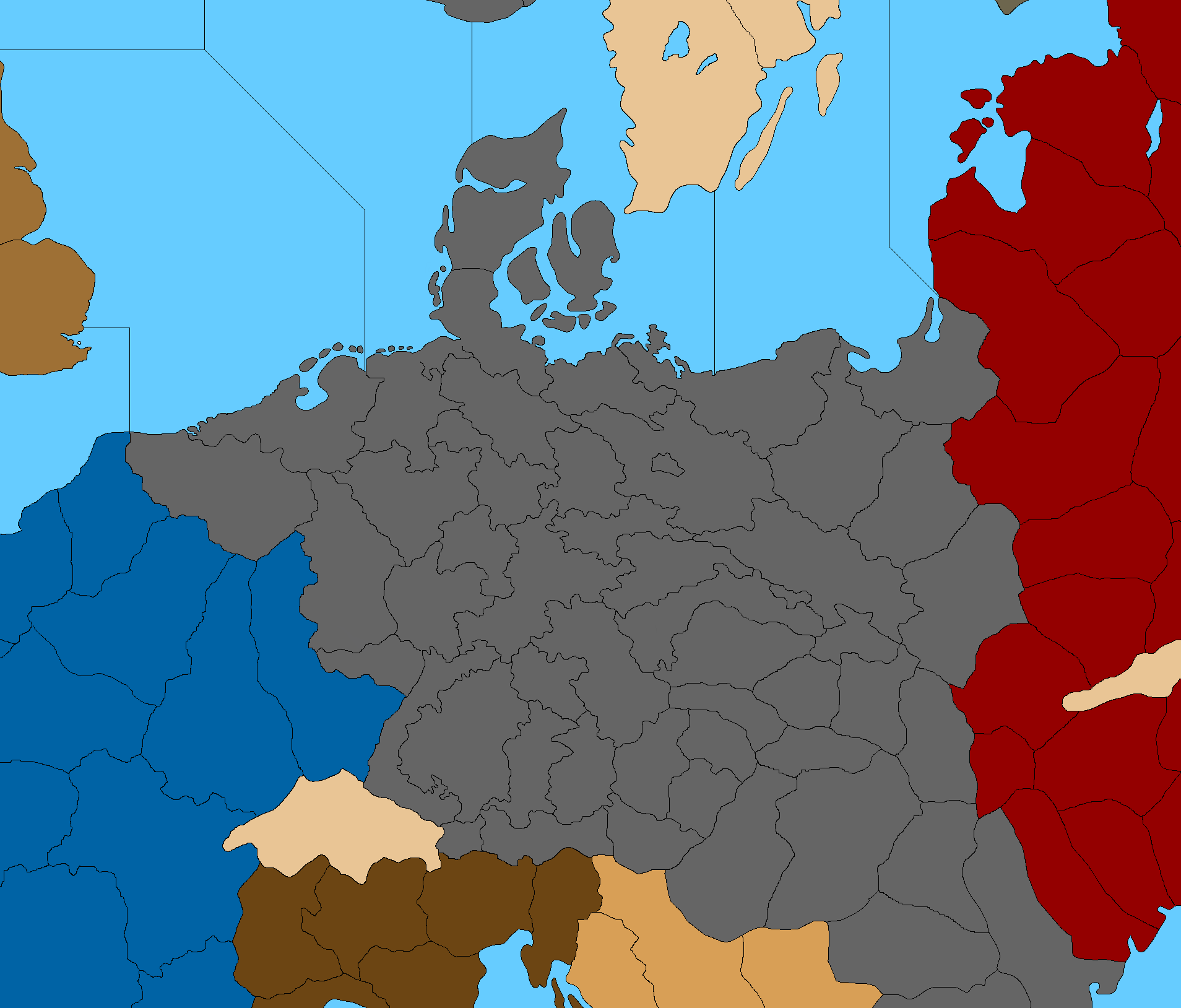
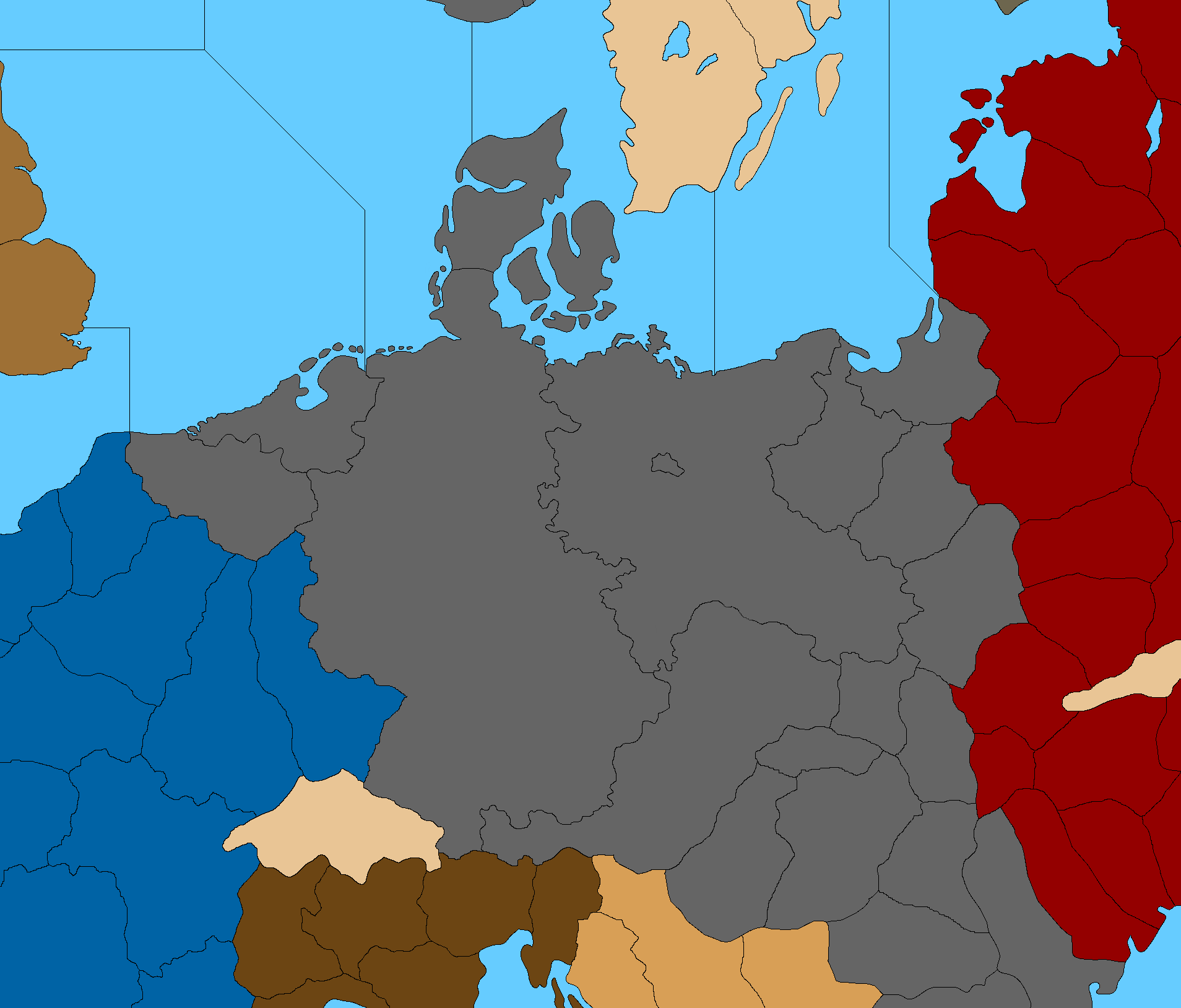
The reason I want to get the G40 stuff in place first, is because we want the subdivisions to just add new lines, rather than moving existing lines. So when I block it in for G40, the subdivided stuff can harmonize with that, with those lines, rather than changing it. Greater Southern Germany in G40 is basically a transit, like it'd be empty for most of the game, unless you're in the final rounds and Germany has already collapsed, so sorta like better to have that zone somewhat smaller and the more important spots above it a bit larger right? Once the spot is sized it's easier to draw the contours so it look alright relative to what's around it.
-
@black_elk said in Proposed Map: Domination 1941:
Air Icon
Naval Icon, with an advanced/sub version
Army/Ground Icon
Special IconYes the above need to be generic for all nations, but they also need to be abstract for they represent moving HQ commands as they add +1 Atk & +1 Def to 5 units they are stacked with, see graphic below.
Currently in game for the Germans is;
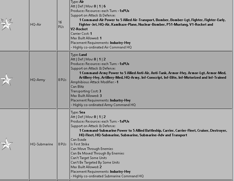
.
.
There are no sub-pens, docks, airfields, this is all subject to change and is represented by simplified multi-function industry (Production, have AA, allow scramble, rail links aid ground units), see below.As an aside, each industry did have research/techToken production but I removed it for now, to keep it simpler.
Currently in game is;
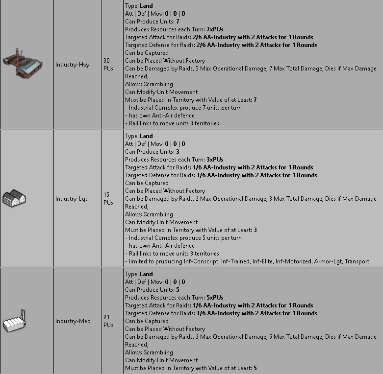
-
@cernel I mean including the territories annexed from Poland.
This source says Germany was 823,505 km2 , United Kingdom is 243,980 km2.
-
OK sounds good, so basically like the Navy gets an anchor motif, Sub some kindof periscope maybe? hehe wings for the Air for sure. I'll see what I can come up with.
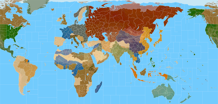
Meantime I think something like this could be interesting for Germany in a super subdivision scenario. Like if you wanted the main Brandenburg tile to cover a lot of surrounding spots to project that way. Here they could attack out of the capital to cover 7 tiles. I think you could bounce between somewhat larger spots for the main stacks, and then some smaller intermediate spots for trading. Here I included Mecklenburg into the main Belin tile. Part of me worries that having the German capital inland might create unintended consequences so I wasn't sure. If one wants Berlin interior, then it could just get added to Pomerania instead, but this seemed like it might meet more traditional expectations from A&A. Basically you'd have the forward coastal spot corresponding roughly to Hanover, and then the fallback spot behind the strait. For the Eastern front we try to get a little bit more dynamism with relatively smaller zones, but still at around that 9x9 threshold. Some spots are just a little tight might have to lose a couple tiles, but sorta like this. I don't know, could be fun hehe
Here it is overlayed with a quickie 1940 paintjob just for the vibe.
-
@black_elk said in Proposed Map: Domination 1941:
anchor motif, Sub some kind of periscope
Great ideas I'm off to find placeholder icons

-
Dear @Black_Elk,
what impassable territory on the map is located in the north of Ukraine?
If it is Pinsk Marshes, then maybe it is more reasonable to make this territory passable by infantry or vice versa by mechanized units on tracks and half-tracks?
If I understand geography correctly, Pinsk Marshes are an obstacle for any army. But they are not more an obstacle than any other major rivers and mountains in Europe like Rhine, Alps, Danube, Carpathians, Dnieper, Don, Volga etc.
For example,
Dnieper is the very wide major river in Ukraine and crossing Dnieper is a nightmare for any army in any month of the year whereas Pinsk Marshes are quite a normal passable territory in winter and summer. -
@unternehmer Yeah that's correct. It is meant to correspond to the Marshes tile in G40.
I'm not sure how I feel about impassible territories in general though, or for a custom game. "Impassibles" are map features introduced in Revised A&A, which didn't exist in Classic A&A, and they're a bit weird. In AA50 and 1942.2 there are quite a few, since every neutral is impassible there.
In Global the concept of neutrality becomes more of a tangle with pro-side and true neutrals, but even that game still has 3 completely impassible spots: The Sahara, the Himalayas, and for some reason Pripet which exists solely to separate Western Ukraine from Belarus.
For my part I don't like True Neutrals and Pro Side neutrals. I like attackable neutrals handled in the sort of standard TripleA/Pact of Steel way. Basically using PU value and static defenses rather than a hard rules type thing for that stuff. Though I suppose movement into/out of/through a tile can definitely be handled in different ways than either OOB or the more simplistic Attackable Neutral type rendition.
One of the admirable things Heppster attempted on his map was the inclusion of 'Seasons' into the gameplay, which would make movement in particular tiles 'slower' during a set time of year. Which might be another approach to such a spot.
The idea of seasons feels novel in A&A, but also somewhat difficult to track, requiring more visual information to be displayed on the map in order to clue the player in to what's happening. Also, in the case of the Hepps maps, with many more tiles than just those 3 mentioned in G40. Like he did the same for monsoons in the jungle tiles and such. A somewhat simpler method would be to abstract everything into a situation where Odd rounds=Movement Open, Even rounds=Movement Closed/Restricted, for any territory that one marks off as having seasonal movement restrictions. Basically keeping the cycles there as simplistic and abstract as possible. But then I worry that stuff like this may be biting off more than one want's to chew for a game like A&A.
Sometimes I think tripleA WW2 maps try to do too much at once. Like the seasons things alone would be sufficient for newness, but combine that with half a dozen other new things and it might be a bit much. I'm sort of an odd duck, in that I don't think G40 is the best A&A game ever. Like not at all, honestly lol. I think it tries to do way too many things, and moves too far away from the familiar A&A. The manual is a brick, and it's just not a very accessible game. I also don't think G40 is too complicated because the map is larger with more TTs/SZs, or because it has a few more unit types. That's not really the issue there. Rather G40 is too complicated because the ruleset involves too much tracking and bean counting, too many factions, too many one off situations/mechanics, and critically because the game is set in 1940 rather than 1941/42, with all that entails for an opener lol. Like pretty much my main preoccupations with G40 are more in finding ways to somehow streamline it and make it just simpler to get into or just to parse. But then people do love it, and I do too in my way. It's probably still our most popular game in tripleA, so even if it's not exactly my favorite favorite thing ever, I still wanted to make sure we had a revamp for that hehe.
For another gain of salt to toss on my salty pile here lol, I'll admit, I'm not a huge fan of basic timelines or timescales in A&A generally. The sort of thing that says "a single game round = 3 months" or whatever. This almost always breaks down immediately, with time moving either too fast or too slow for the gameplay to sync with the impressionistic vibe that the player's got going on in their head. I much prefer a scheme where this is left unstated, so that the player can determine what "Year/Month" it is, based more on the position of forces on the gameboard and what's actually happening with the gameplay, rather than on the game round. In my view this provides more flexibility for the players to suspend disbelief and abstract their playpattern to harmonize with certain timeline expectations in a more freeform way. In other words if the Normandy landings happen in round 7, then round 7 is June 1944. If instead the Normandy landings happen in round 11, then round 11 is June 1944.
You don't need to tie it to a hard timetable where 1 round = 1 year or .5 or .33 or .25 years, because the player can create this sense of a timeline in their heads and it's a lot less disruptive. To put it another way, players shouldn't feel like they're running slow and way behind schedule, or playing into the 1960s simply because the endgame goes on longer than expected. The way I see it there is only one time that really matters, and that's the start date of the opening round. If the playpattern for that date feels right in the opener, meaning the playpattern and opening moves fit that sense of a "starting point" that's all you really need. The player will supply everything else in their imagination, and it's better when this isn't hindered by an hourglass that could only ever be a distortion anyway, since the game is turn based hehe.
I don't know if my take on that stuff is a majority view though. Many tripleA map designers seem to like the idea of attaching a game round to a set length of fixed time, but I just think it inevitably comes unhinged. As soon as you state the timeframe in terms of game rounds, something on the gameboard will happen to shatter that impression. So I like something that's more binary on/off, if one wanted to include such a feature for restrictions on army movement in spots like the Marshes, or the Desert, or for some of those Sea Zones in the Arctic or whatever.
As Cernel mentioned somewhere, I think earlier in this thread, virtually no territory on the gameboard would have been truly impassible for a modern army, and there are mountain passes and such going back to ancient times. Just like it's hard to imagine Spain or Turkey being totally impassible based simply on a political situation. It might be more costly and logistically challenging sure, but not really an invisible wall like the game tends to treat this stuff hehe.
The whole purpose of the Sahara seems to be just making Egypt a more critical tile, and to make it somewhat harder for either side to just sweep the African continent with a couple blitz moves like in Classic. The Himalayas seems to do something similar with China/India vs Japan's movement. Pripet seems to exist to force the Germans to split into 2 main stacks rather than just a single big ball of fury on the Eastern Front, but it's kinda slim even for that, and just sort of makes the importance of Bryansk and Belarus more pronounced relative to their neighbors. Not sure that people would even want to see stuff like that in a more subdivided map, but they exist here purely for the G40 adaptation.
Here is a quickie paintjob, showing White border lines and standard color fill for G40
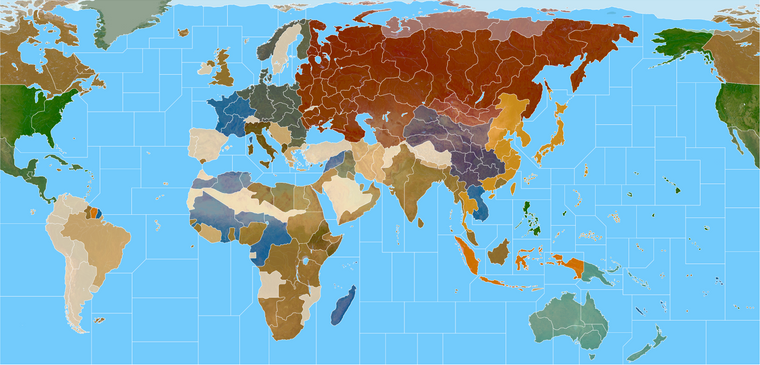
Here's the same but with Black border lines, and punched up/colored borders. Basically you can change the opacity/gradient depending on how much of the terrain one wants to show through or how much color one wants to see on the borders vs interior of the tiles. Black lines tend to make the boundaries feel a bit more subdued, whereas white makes them pop a bit more. Some of it comes down to the value of the colors chosen (how light or dark they are, especially relative to the SZ color choice.) I'm not sure which presentation I like better, so I keep bouncing back and forth on that one. Also because it helps me to locate floating pixels while working hehe.
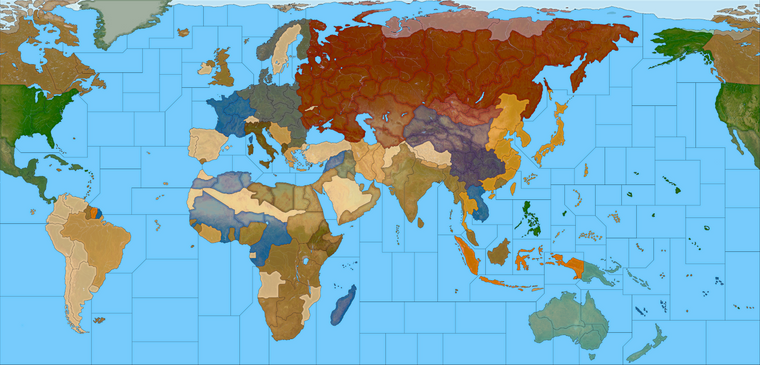
Looking at the way that one previews when downscaled I almost think something wider than 5 px might be better. It's basically that odd/even split thing again, when depending on the scale the machine will struggle to fill in a 1px gap. Since for the preview I had to go under 20%, some of those lines display slightly thicker than others in the preview. Or could just be the hard and fast way I did the baseline layer there, cause I didn't isolate the Ocean tiles like I should have they show some opacity changes which could be creating that visual effect. Not totally sure. I think as long as they don't completely disappear we're probably ok and I can clean up the final for either approach lol.
I also tried a version with White lines at Sea and Black lines on land, then another version that just showed colored borders with no interior fills for either color, just the terrain at 100% opacity, but I quite didn't like the way those carried as visuals. Just felt too frenetic and too patchy somehow.
I think most players would have clear preference for one or the other, either White boundaries or Black, sorta the same way they might like light blue or dark blue for the Oceans, depending on whether they vibe more on a Classic or Revised style palette overall. I think digital players will almost certainly prefer a color fill/gradient, since this is the main advantage of the digital game over the physical one where people have to use roundels to indicate ownership. Also for the whole "paint the map your colors" appeal.
I'll probably do at least 2 versions, one black lines and one white lines - and then probably 2 versions of the paintjob, one that has a more Digital play color fill, and another more Analog (Terrain) like the OOB look, just to keep everyone happy hehe.
The colors chosen for each nation here would depend somewhat on the desired opacity of the painted layer atop the terrain relief layer. The more opaque that painted layer is, the closer it will display to the nation's HEX color. Also the darker the color-value of that nation's HEX, the more the terrain layer underneath will read through it. For example if I make Germany 100% black, rather than 50% Gray for their HEX color, then the terrain in TT's they control will show through completely, and the German TTs will just look like whatever the terrain color is underneath, mostly dark green where they're starting. So it's a bit of a balance there. The closer the HEX color is to a midrange value, the better it tends reads in that sort of display, showing the difference in Hue more than Value/Sat. People have wildly different color preferences though, so I'd anticipate players may just change the HEX codes in mapProperties to suit their tastes there. So really we're just giving a default suggestion there, for something that the player should be able to change. The limiting factor there is mainly the unit tints, since I don't think tripleA has a built in colorize feature for that yet, and it's been a few years since the idea was first floated. Doing it manually can be annoying, just because of the sheer number of tiny images involved. Like you might take the time to open 30+ units in GIMP and colorize each one individually for one Nation, but doing that for each nation is a definite chore. I'd maybe try for 2 tint sets for each basic nation/color, and then just put those somewhere that players could quickly download them. So for example, if you want Japan to be Orange instead of Ochre, or Germany to be Blue/Gray rather than Black, you could just download that set and be good to go in a few quick clicks.
Also thanks for the feedback! That was big old ramble on my part lol, but just kinda sketching out my thoughts for some of that stuff, to see what resonates with others or if I'm way off base heheh.
Catch ya in a few!
ps. Also talking about the marshes made me realize that somehow the Bryansk connection is off lol. I thought I fixed it but maybe got lost in the shuffle. Basically just need a line to split that connection W. Ukraine to Bryansk cause right now the Ukraine TT is separating them. I'll fix it in the baseline and on the next pass.
Here is the corrected baseline with the Oceans painted back in. I caught a couple openings in a few spots so closed those up. I folded E. Prussia into W. Poland tile, and the stuff along the Gulf coast, just so it could match the OOB presentation. For Tibet I'd just make it part of the mountain tile there. Some extra islands are depicted that aren't really necessary, but they can just be folded into an adjacent tile I'd think. Just give a few more places to put some centers. I beefed up Smolensk and Volgograd a little bit as well.
Global
https://www.dropbox.com/s/4740bj0l87sbb57/World_War_II_Global_1940_baseline.png?dl=0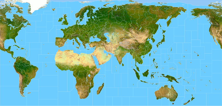
Here's the Domination one to match
https://www.dropbox.com/s/khxkql58g73q1n3/Domination_1940_baseline.png?dl=0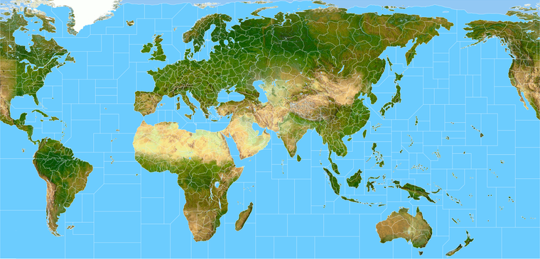
-
@black_elk
I notice that the Domination map has lots of extra SZ, this means ships will have to move 3, maybe 4.
I thought for SZ we were going for the same SZ as Global 40 ? So ship movement was 2.I am not a A&A WW2 player, but my gut tells me that ship move 2 would overall be better.
-
Dear @Black_Elk,
thank you very much for your feedback!
I am sorry, but I still don’t understand why Pinsk marshes are impassable when they are “much more passable” than Rhine, Carpatians, Danube, Dnieper, Don, Volga etc.
To my mind, “impassable territory” should only stand for real impassable territory (like the Sahara Desert) impossible to cross by any army. Impossible means “really absolutely impossible at any time of the year”.
Pinsk Marshes are passable difficult terrain only in spring/autumn and are passable normal terrain in winter/summer.
So, Pinsk Marshes are passable at any time of the year and are more passable than any major rivers or mountains in Europe. And of course, Pinsk Marshes are much more passable than any jungles in Latin America, Africa, and Asia.
To the idea, that “Pinsk Marshes divide front in two separate parts”:
If Pinsk Marshes divide front in two separate parts, then this statement even much more corresponds to Rhine, Carpatians, Danube, Dnieper, Don, Volga etc.
For example, Carpatians really divide front in separate parts much more than Pinsk Marshes because Carpatians are always a passable difficult terrain whereas Pinsk Marshes are passable difficult terrain only in spring/autumn and are passable normal terrain in winter/summer.
-
@unternehmer
Im doing my code thing over here
https://forums.triplea-game.org/topic/3326/1941-command-decision-code
and will be using Black_Elk map.The Pinsk marshes are 480 kilometres (300 mi) west to east and 225 kilometres (140 mi) north to south. This is taken from here
https://en.wikipedia.org/wiki/Pinsk_Marshes;
and so is this quote.
They often needed to build tracks with logs, over which they could pull light loads in horse-drawn vehicles.[6]My take on the Pinsk marshes is Infantry can move through it, but anything else cannot.
-
@thedog said in Proposed Map: Domination 1941:
My take on the Pinsk marshes is Infantry can move through it, but anything else cannot.
Till there boots fall off
 heh heh
Yea, that seems reasonable. Can't remember, but I thought retreating commies hid in the marshes while trying to make there way back to there own lines, only to be sent to penal battalions for there failure. lol I could be wrong though.
@Unternehmer
I think Larry was looking a little more big picture without getting to detailed. Wanted to represent a more historical path for the Panzers.Could very well be wrong on both accounts though
 . The cool thing is, you can use Elks map and change it from impassable or only for some units as Dog suggested or weather effects etc.
It's a Beauty and I dig it

-
@unternehmer said in Proposed Map: Domination 1941:
Dear @Black_Elk,
thank you very much for your feedback!
I am sorry, but I still don’t understand why Pinsk marshes are impassable when they are “much more passable” than Rhine, Carpatians, Danube, Dnieper, Don, Volga etc.
To my mind, “impassable territory” should only stand for real impassable territory (like the Sahara Desert) impossible to cross by any army. Impossible means “really absolutely impossible at any time of the year”.
Pinsk Marshes are passable difficult terrain only in spring/autumn and are passable normal terrain in winter/summer.
So, Pinsk Marshes are passable at any time of the year and are more passable than any major rivers or mountains in Europe. And of course, Pinsk Marshes are much more passable than any jungles in Latin America, Africa, and Asia.
To the idea, that “Pinsk Marshes divide front in two separate parts”:
If Pinsk Marshes divide front in two separate parts, then this statement even much more corresponds to Rhine, Carpatians, Danube, Dnieper, Don, Volga etc.
For example, Carpatians really divide front in separate parts much more than Pinsk Marshes because Carpatians are always a passable difficult terrain whereas Pinsk Marshes are passable difficult terrain only in spring/autumn and are passable normal terrain in winter/summer.
The Sahara desert is not impassable. There are areas within the Sahara desert which are virtually impassable, but most of the Sahara desert is easily transitable. The main issue for the Axis was the near total absence of railways, but that is not the desert's fault.
I already explained it a few days ago:
@cernel said in Fortress World 1942:- Do you think should Sahara Desert really be represented?
Not the desert as a whole, of course: only the sand-seas are virtually impassable. The main ones are El Djouf, Erg Iguidi and Chech, the Grand Occidental Erg (wich can be represented as a single sand sea together with the contiguous Iguidi and Chech), the Grand Oriental Erg, Idehan Ubari, Idehan Murzuk (there is a very slim passable corridor cutting through these two, the main hub being the city of Murzuk), the Ramlat Rebiana, the Great Sand Sea (which can be represented as contiguous with the Ramlat Rebiana, practically making the Ramlat Rebiana part of the Great Sand Sea). Another candidate may be the Erg of Bilma, but I don't personally consider it to be a proper sand sea, so I doubt I would have it as impassable, but it's disputable. Of course, also don't forget the salt flats, which are about as impassable as the sand seas. Obviously, the most important salt pan is the one south of El Alamein (which is continued eastward by an adjacent sand sea), which is nearby but not contiguous with the Great Sand Sea (as there is a small strip of passable land whose main hub may be the settlement of Bahariya). Also the one almost cutting Tunisia in two is obviously important. Moreover, don't forget to do the same for the sand seas in Arabia (two main ones and a sand sea strip which almost connects the two nearby Riyadh) and, of course, the about as big Taklamakan desert, which is actually two sand seas split by the Khotan river, of course. I'm thinking the only non-African very important salt pans are the one between Pakistan (of course, not called as such at the time) and what is now India near the coast and the one south-west of Afghanistan. All the other ones should be pretty small for the size of your map. Also I guess the sand seas between Ningsia and the Kansu corridor may be too small to worry about in a map like the one you have. Other impassables are the big lakes, of course. Three big ones in Africa, two in Europe, four in Asia (counting also the Garabogazköl), all the great lakes between the United States and Canada plus two or three other ones in Canada itself. I think South America has just a few small salt pans and no deserts, so I think impassables are not needed there (unless you want to do something about the Amazon, which would then require being consistent with similar jungles in other parts of the world), and I would say that none of the Australian deserts is really impassable, especially in a map like this one. A questionable one is, of course, the Changthang, which is, however, not impassable per se (but it has almost no population and virtually no infrastructures).
The "Pripet Marshes" could be represented with a quadripoint, by the way (and nothing would change for gameplay). I'm not suggesting it.
Marshes are highly disruptive of any normal line of defence because you cannot have trenches in marshes, so they did have the effect to split the frontline in two if the frontline ran through them. I guess the impassable nature of the territory is meant loosely to capture this effect.
-
Yeah I honestly wasn't sure what people wanted for SZ divisions.
OOB Global has 128 SZ tiles. The old Domination map I made used in NML had 155 SZ tiles. Hepster's Power of Politics 1914 version has 220 SZ tiles and 38 Convoy circle tiles - one of the more divided up oceans I've seen in a tripleA world war map.
I haven't counted them, but I'd guess the above design has something like 200 SZ tiles, which I included mainly for Kurt I guess, since he wanted something similar to NML just with more divisions I think. If using more SZ divisions than OOB Global, there's also a question of how to number them.
In Domination I basically went Left to Right, Top to Bottom and numbered them all in a boustrophedon sweep like the older A&A boards. A&A Global 1940 did not yet exist when I started making the Domination idea with Surtur, so we didn't have that example to go off at the time. The first Pact of Steel game for tripleA was similar, in that we made that one like a year in advance of AA50 coming out, so it is similar in some ways to AA50, but in many other ways not so much lol.
G40 does the reverse for SZ labelling, since it begins the numbering at the Top Right of the map and ends at the Top left. G40 was the first A&A gameboard to change this. In Classic to AA50/42.2 SZ 1 was always in the Atlantic off Eastern Canada, and the count moved boustrophedon to the right, down and back up again to finish at Alaska. G40 starts the count at Alaska and moves left. It's a little weird in my view, but that's OOB for ya lol.
My thought would be to use G40 as the guide, but to do the labelling Alpha-Numeric for any new Sea Zones added in a more subdivided map. So instead of having Sz 1, Sz 2, Sz 3 etc. You might have Sz 1A, SZ 1B, then Sz 2A and Sz 2B, just to keep the overall SZ labelling familiar for players coming from G40, so that the SZ names/locations aren't totally different from OOB expectations.
If one just wants to keep OOB G40 sea zones with no additional divisions, that's relatively simple, cause it's just the eraser. I can isolate the two maps to only use the simpler Sz divisions but the more subdivided landmap.
I think there is also an issue of how to handle any extra Cash awarded for control of SZ stuff. If one simply makes all OOB G40 sea zones worth 1 PU, that's 128 extra PUs in play, but then there's a question of how those are assigned initially, eg who controls that money at the outset and how this might change the playpattern. I think it may be more expedient to use Europe/Pacific style convoys at higher values and just sort of insert them where it makes sense. But for me this is all still a bit fuzzy in terms of what people want hehe. I'm just trying to imagine unintended consequences that might bust it, to see how those might be avoided lol. Speaking of which...
So for the idea that certain Territories might be partially impassible, impassible only for certain unit types, or open/closed in some kind of alternating way by game round, I think that may work, but it also creates some potential dilemmas/exploits. Like what happens to units that end their turn in such a spot, or get cut off, and then whether that can be gamed in ways we don't really want? In other words, I don't think we want a situation where the Russians or Germans can move a large Infantry stack into the marshes, and then just post up there, having those units being immune from attack on the opponent's turn or whatever. Or similarly having a situation where the Sahara unintentionally becomes like the most valuable space in North Africa, but just in some weird gamey sort of way, where only infantry and aircraft can be involved in the fights to control it. It's hard to predict how stuff might be gamed out, but just trying to hold it in mind. Hepster created a whole system for 6 Seasonal Weather effects in the Power of Politics map, but the game file and notes are incomplete. I believe his idea was not to restrict the movement of forces into the tiles per se, but rather to have it effect the combat abilities of the units occupying those spots when a seasonal effect was active there.
As to why Larry and Kevin decided to include Pripet and make it impassible in G40 the way they did, hard to say. Beats me honestly. But it's definitely on the G40 gameboard, so that's why I included it. Though I tried to make it as thin as possible so as not to eat into the other surrounding TTs too hard heheh
-
@black_elk said in Proposed Map: Domination 1941:
As to why Larry and Kevin decided to include Pripet and make it impassible in G40 the way they did, hard to say. Beats me honestly. But it's definitely on the G40 gameboard, so that's why I included it. Though I tried to make it as thin as possible so as not to eat into the other surrounding TTs too hard heheh
As I said, it's not strictly necessary to include it as having a quadripoint in its place would give the same game-play. I'm not saying this would be something most people would prefer.
It looks like you already removed the also pointless Yukon Territory.
-
@thedog said in Proposed Map: Domination 1941:
@unternehmer
Im doing my code thing over here
https://forums.triplea-game.org/topic/3326/1941-command-decision-code
and will be using Black_Elk map.The Pinsk marshes are 480 kilometres (300 mi) west to east and 225 kilometres (140 mi) north to south. This is taken from here
https://en.wikipedia.org/wiki/Pinsk_Marshes;
and so is this quote.
They often needed to build tracks with logs, over which they could pull light loads in horse-drawn vehicles.[6]My take on the Pinsk marshes is Infantry can move through it, but anything else cannot.
Dear @TheDog,
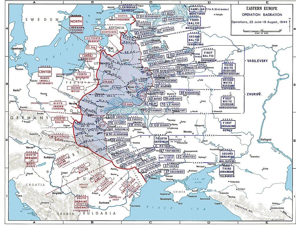
please see on Wiki “Operation Bagration” and particularly the part “Bobruysk offensive (23–28 June 1944)”
https://en.wikipedia.org/wiki/Bobruysk_offensiveIssa Pliev's Cavalry-Mechanized Group (consisting of the 4th Guards Cavalry Corps and the 1st Mechanised Corps) was able to travel across the adverse terrain of the marshes without much challenges, and struck the German Ninth Army's southern flank.
If I understand English Wiki correctly, 2 full Soviet Corps with heavy tanks and howitzers were able to pass through Pinsk Marshes from southeast to northwest in summer 1944 without any problems, keep the battle order and have enough supplies to go on flanking offensive without any delay. And it took them only 2 days (24-26 June 1944) to pass through Pinsk Marshes and strike the German flank!!!
So, your take is:
@TheDog: “My take on the Pinsk marshes is Infantry can move through it, but anything else cannot.”But as Wiki says, Pinsk Marshes can be easily simultaneously passed in summer by 2 full mechanized Army Corps at once in just 2 days!!!
-
@unternehmer
I am no ww2 historian, but Operation Bagration/Bobruysk offensive was to the north east of the main marsh area, see map below.As my scenario does not do seasons, that is summer, Im still going with passable to just infantry as that would appear to true for the majority of the year as a compromise.
-
Dear @TheDog,
how do you estimate the size of the Pinsk Marshes on the @Black_Elk’s great map?
When I look onto your historical map of the Operation Bagration, I think it is more realistic for the Pinsk Marshes territory on the @Black_Elk’s great map to be 2 times less stretched from west to east and to be 2 times wider from north to south.
-
@unternehmer Im not sure which territory(s) @Black_Elk had in mind to be the marshes, hopefully he can answer your question.