Proposed Map: Domination 1941
-
@black_elk
I notice that the Domination map has lots of extra SZ, this means ships will have to move 3, maybe 4.
I thought for SZ we were going for the same SZ as Global 40 ? So ship movement was 2.I am not a A&A WW2 player, but my gut tells me that ship move 2 would overall be better.
-
Dear @Black_Elk,
thank you very much for your feedback!
I am sorry, but I still don’t understand why Pinsk marshes are impassable when they are “much more passable” than Rhine, Carpatians, Danube, Dnieper, Don, Volga etc.
To my mind, “impassable territory” should only stand for real impassable territory (like the Sahara Desert) impossible to cross by any army. Impossible means “really absolutely impossible at any time of the year”.
Pinsk Marshes are passable difficult terrain only in spring/autumn and are passable normal terrain in winter/summer.
So, Pinsk Marshes are passable at any time of the year and are more passable than any major rivers or mountains in Europe. And of course, Pinsk Marshes are much more passable than any jungles in Latin America, Africa, and Asia.
To the idea, that “Pinsk Marshes divide front in two separate parts”:
If Pinsk Marshes divide front in two separate parts, then this statement even much more corresponds to Rhine, Carpatians, Danube, Dnieper, Don, Volga etc.
For example, Carpatians really divide front in separate parts much more than Pinsk Marshes because Carpatians are always a passable difficult terrain whereas Pinsk Marshes are passable difficult terrain only in spring/autumn and are passable normal terrain in winter/summer.
-
@unternehmer
Im doing my code thing over here
https://forums.triplea-game.org/topic/3326/1941-command-decision-code
and will be using Black_Elk map.The Pinsk marshes are 480 kilometres (300 mi) west to east and 225 kilometres (140 mi) north to south. This is taken from here
https://en.wikipedia.org/wiki/Pinsk_Marshes;
and so is this quote.
They often needed to build tracks with logs, over which they could pull light loads in horse-drawn vehicles.[6]My take on the Pinsk marshes is Infantry can move through it, but anything else cannot.
-
@thedog said in Proposed Map: Domination 1941:
My take on the Pinsk marshes is Infantry can move through it, but anything else cannot.
Till there boots fall off
 heh heh
Yea, that seems reasonable. Can't remember, but I thought retreating commies hid in the marshes while trying to make there way back to there own lines, only to be sent to penal battalions for there failure. lol I could be wrong though.
@Unternehmer
I think Larry was looking a little more big picture without getting to detailed. Wanted to represent a more historical path for the Panzers.Could very well be wrong on both accounts though
") . The cool thing is, you can use Elks map and change it from impassable or only for some units as Dog suggested or weather effects etc.
. The cool thing is, you can use Elks map and change it from impassable or only for some units as Dog suggested or weather effects etc.It's a Beauty and I dig it
-
@unternehmer said in Proposed Map: Domination 1941:
Dear @Black_Elk,
thank you very much for your feedback!
I am sorry, but I still don’t understand why Pinsk marshes are impassable when they are “much more passable” than Rhine, Carpatians, Danube, Dnieper, Don, Volga etc.
To my mind, “impassable territory” should only stand for real impassable territory (like the Sahara Desert) impossible to cross by any army. Impossible means “really absolutely impossible at any time of the year”.
Pinsk Marshes are passable difficult terrain only in spring/autumn and are passable normal terrain in winter/summer.
So, Pinsk Marshes are passable at any time of the year and are more passable than any major rivers or mountains in Europe. And of course, Pinsk Marshes are much more passable than any jungles in Latin America, Africa, and Asia.
To the idea, that “Pinsk Marshes divide front in two separate parts”:
If Pinsk Marshes divide front in two separate parts, then this statement even much more corresponds to Rhine, Carpatians, Danube, Dnieper, Don, Volga etc.
For example, Carpatians really divide front in separate parts much more than Pinsk Marshes because Carpatians are always a passable difficult terrain whereas Pinsk Marshes are passable difficult terrain only in spring/autumn and are passable normal terrain in winter/summer.
The Sahara desert is not impassable. There are areas within the Sahara desert which are virtually impassable, but most of the Sahara desert is easily transitable. The main issue for the Axis was the near total absence of railways, but that is not the desert's fault.
I already explained it a few days ago:
@cernel said in Fortress World 1942:- Do you think should Sahara Desert really be represented?
Not the desert as a whole, of course: only the sand-seas are virtually impassable. The main ones are El Djouf, Erg Iguidi and Chech, the Grand Occidental Erg (wich can be represented as a single sand sea together with the contiguous Iguidi and Chech), the Grand Oriental Erg, Idehan Ubari, Idehan Murzuk (there is a very slim passable corridor cutting through these two, the main hub being the city of Murzuk), the Ramlat Rebiana, the Great Sand Sea (which can be represented as contiguous with the Ramlat Rebiana, practically making the Ramlat Rebiana part of the Great Sand Sea). Another candidate may be the Erg of Bilma, but I don't personally consider it to be a proper sand sea, so I doubt I would have it as impassable, but it's disputable. Of course, also don't forget the salt flats, which are about as impassable as the sand seas. Obviously, the most important salt pan is the one south of El Alamein (which is continued eastward by an adjacent sand sea), which is nearby but not contiguous with the Great Sand Sea (as there is a small strip of passable land whose main hub may be the settlement of Bahariya). Also the one almost cutting Tunisia in two is obviously important. Moreover, don't forget to do the same for the sand seas in Arabia (two main ones and a sand sea strip which almost connects the two nearby Riyadh) and, of course, the about as big Taklamakan desert, which is actually two sand seas split by the Khotan river, of course. I'm thinking the only non-African very important salt pans are the one between Pakistan (of course, not called as such at the time) and what is now India near the coast and the one south-west of Afghanistan. All the other ones should be pretty small for the size of your map. Also I guess the sand seas between Ningsia and the Kansu corridor may be too small to worry about in a map like the one you have. Other impassables are the big lakes, of course. Three big ones in Africa, two in Europe, four in Asia (counting also the Garabogazköl), all the great lakes between the United States and Canada plus two or three other ones in Canada itself. I think South America has just a few small salt pans and no deserts, so I think impassables are not needed there (unless you want to do something about the Amazon, which would then require being consistent with similar jungles in other parts of the world), and I would say that none of the Australian deserts is really impassable, especially in a map like this one. A questionable one is, of course, the Changthang, which is, however, not impassable per se (but it has almost no population and virtually no infrastructures).
The "Pripet Marshes" could be represented with a quadripoint, by the way (and nothing would change for gameplay). I'm not suggesting it.
Marshes are highly disruptive of any normal line of defence because you cannot have trenches in marshes, so they did have the effect to split the frontline in two if the frontline ran through them. I guess the impassable nature of the territory is meant loosely to capture this effect.
-
Yeah I honestly wasn't sure what people wanted for SZ divisions.
OOB Global has 128 SZ tiles. The old Domination map I made used in NML had 155 SZ tiles. Hepster's Power of Politics 1914 version has 220 SZ tiles and 38 Convoy circle tiles - one of the more divided up oceans I've seen in a tripleA world war map.
I haven't counted them, but I'd guess the above design has something like 200 SZ tiles, which I included mainly for Kurt I guess, since he wanted something similar to NML just with more divisions I think. If using more SZ divisions than OOB Global, there's also a question of how to number them.
In Domination I basically went Left to Right, Top to Bottom and numbered them all in a boustrophedon sweep like the older A&A boards. A&A Global 1940 did not yet exist when I started making the Domination idea with Surtur, so we didn't have that example to go off at the time. The first Pact of Steel game for tripleA was similar, in that we made that one like a year in advance of AA50 coming out, so it is similar in some ways to AA50, but in many other ways not so much lol.
G40 does the reverse for SZ labelling, since it begins the numbering at the Top Right of the map and ends at the Top left. G40 was the first A&A gameboard to change this. In Classic to AA50/42.2 SZ 1 was always in the Atlantic off Eastern Canada, and the count moved boustrophedon to the right, down and back up again to finish at Alaska. G40 starts the count at Alaska and moves left. It's a little weird in my view, but that's OOB for ya lol.
My thought would be to use G40 as the guide, but to do the labelling Alpha-Numeric for any new Sea Zones added in a more subdivided map. So instead of having Sz 1, Sz 2, Sz 3 etc. You might have Sz 1A, SZ 1B, then Sz 2A and Sz 2B, just to keep the overall SZ labelling familiar for players coming from G40, so that the SZ names/locations aren't totally different from OOB expectations.
If one just wants to keep OOB G40 sea zones with no additional divisions, that's relatively simple, cause it's just the eraser. I can isolate the two maps to only use the simpler Sz divisions but the more subdivided landmap.
I think there is also an issue of how to handle any extra Cash awarded for control of SZ stuff. If one simply makes all OOB G40 sea zones worth 1 PU, that's 128 extra PUs in play, but then there's a question of how those are assigned initially, eg who controls that money at the outset and how this might change the playpattern. I think it may be more expedient to use Europe/Pacific style convoys at higher values and just sort of insert them where it makes sense. But for me this is all still a bit fuzzy in terms of what people want hehe. I'm just trying to imagine unintended consequences that might bust it, to see how those might be avoided lol. Speaking of which...
So for the idea that certain Territories might be partially impassible, impassible only for certain unit types, or open/closed in some kind of alternating way by game round, I think that may work, but it also creates some potential dilemmas/exploits. Like what happens to units that end their turn in such a spot, or get cut off, and then whether that can be gamed in ways we don't really want? In other words, I don't think we want a situation where the Russians or Germans can move a large Infantry stack into the marshes, and then just post up there, having those units being immune from attack on the opponent's turn or whatever. Or similarly having a situation where the Sahara unintentionally becomes like the most valuable space in North Africa, but just in some weird gamey sort of way, where only infantry and aircraft can be involved in the fights to control it. It's hard to predict how stuff might be gamed out, but just trying to hold it in mind. Hepster created a whole system for 6 Seasonal Weather effects in the Power of Politics map, but the game file and notes are incomplete. I believe his idea was not to restrict the movement of forces into the tiles per se, but rather to have it effect the combat abilities of the units occupying those spots when a seasonal effect was active there.
As to why Larry and Kevin decided to include Pripet and make it impassible in G40 the way they did, hard to say. Beats me honestly. But it's definitely on the G40 gameboard, so that's why I included it. Though I tried to make it as thin as possible so as not to eat into the other surrounding TTs too hard heheh
-
@black_elk said in Proposed Map: Domination 1941:
As to why Larry and Kevin decided to include Pripet and make it impassible in G40 the way they did, hard to say. Beats me honestly. But it's definitely on the G40 gameboard, so that's why I included it. Though I tried to make it as thin as possible so as not to eat into the other surrounding TTs too hard heheh
As I said, it's not strictly necessary to include it as having a quadripoint in its place would give the same game-play. I'm not saying this would be something most people would prefer.
It looks like you already removed the also pointless Yukon Territory.
-
@thedog said in Proposed Map: Domination 1941:
@unternehmer
Im doing my code thing over here
https://forums.triplea-game.org/topic/3326/1941-command-decision-code
and will be using Black_Elk map.The Pinsk marshes are 480 kilometres (300 mi) west to east and 225 kilometres (140 mi) north to south. This is taken from here
https://en.wikipedia.org/wiki/Pinsk_Marshes;
and so is this quote.
They often needed to build tracks with logs, over which they could pull light loads in horse-drawn vehicles.[6]My take on the Pinsk marshes is Infantry can move through it, but anything else cannot.
Dear @TheDog,
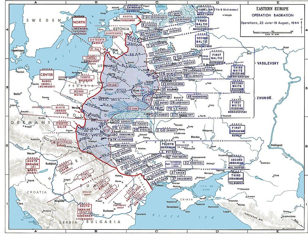
please see on Wiki “Operation Bagration” and particularly the part “Bobruysk offensive (23–28 June 1944)”
https://en.wikipedia.org/wiki/Bobruysk_offensiveIssa Pliev's Cavalry-Mechanized Group (consisting of the 4th Guards Cavalry Corps and the 1st Mechanised Corps) was able to travel across the adverse terrain of the marshes without much challenges, and struck the German Ninth Army's southern flank.
If I understand English Wiki correctly, 2 full Soviet Corps with heavy tanks and howitzers were able to pass through Pinsk Marshes from southeast to northwest in summer 1944 without any problems, keep the battle order and have enough supplies to go on flanking offensive without any delay. And it took them only 2 days (24-26 June 1944) to pass through Pinsk Marshes and strike the German flank!!!
So, your take is:
@TheDog: “My take on the Pinsk marshes is Infantry can move through it, but anything else cannot.”But as Wiki says, Pinsk Marshes can be easily simultaneously passed in summer by 2 full mechanized Army Corps at once in just 2 days!!!
-
@unternehmer
I am no ww2 historian, but Operation Bagration/Bobruysk offensive was to the north east of the main marsh area, see map below.As my scenario does not do seasons, that is summer, Im still going with passable to just infantry as that would appear to true for the majority of the year as a compromise.
-
Dear @TheDog,
how do you estimate the size of the Pinsk Marshes on the @Black_Elk’s great map?
When I look onto your historical map of the Operation Bagration, I think it is more realistic for the Pinsk Marshes territory on the @Black_Elk’s great map to be 2 times less stretched from west to east and to be 2 times wider from north to south.
-
@unternehmer Im not sure which territory(s) @Black_Elk had in mind to be the marshes, hopefully he can answer your question.
-
I kinda pause the work on the map to just try to get a handle on the unit stuff, but we can tweak it for the marshes or make it as large or small as one wanted, or eliminate it entirely as Cernel suggested. But maybe something like this where we just pull a bit to the left and a little taller. Basically trying to keep as much room for Belarus and Bryansk and Ukraine for stacking.
https://www.dropbox.com/s/4740bj0l87sbb57/World_War_II_Global_1940_baseline.png?dl=0
Fidelity to the OOB game board is the only reason it's there. The thought being that players familiar with OOB G40 or Bung's current G40 map in tripleA, should be able to open this one, parse it relatively quickly to see how it's the same, without being too disoriented. OOB the Marshes tile is quite large both on the board and in Bung's, like it's bigger than Morocco lol, even though it doesn't need to house any units lol, and it extends to cover basically the whole border between 'Western Ukraine' and Belarus, which is maybe not aces for the labelling but is nevertheless what the game board does. I'd ditch it with a 4 point but then worried that might just confuse people. Like they'd see it's gone and think hmmm. I mean I did ditch Yukon but that was more cause I didn't like the grayed out look from the tile that only exists in 1st ed. People would just go by the Second Ed board by now, so didn't really seem needed, though you could add it back like in the earlier draft if one wanted I guess. To me the above felt (as many things do) like a sensible enough compromise for the marshes. Like if you wanted to have it just big enough to fit a few unit types you could maybe still squeeze em in there, but it didn't seem like a huge priority for the G40 scale game hehe.
-
@Unternehmer
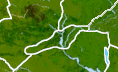
For my map, 1941 Command Decision, I will be using Black_Elk more detailed map. This is the territory for the marshes, one in the middle.
Dont be too bothered by the marshes size, from my point of view as long as they can hold 3 infantry types Conscript, Regular, Elite) without overflowing that is all I need and they are connected correctly to other territories.
Unternehmer you have probably realised, like me, that it is not easy squeezing, pushing, reshaping territories into the earths outline, then layering political and geographical borders to fit 9-ish units in, so it looks great for game play, go Black_Elk.
@Black_Elk
The end is in sight, again.
How many times have you heard that!
-
Here's a quick example showing the G40 map in Europe with units at 150%
I had to index the image to get the filesize down low enough to attach it here on the boards, so it's a little choppy, but gives a sense of how things might look.
I think it looks pretty good with the tinted units. I added the control flags to help clarify TT ownership. I figure the flag could go wherever the production value label of the TT would go, for a splash of color and added clarity, esp in TTs that are empty of units to make it easier to see which power has ownership. I forgot to upscale the French flags there I guess lol, but something sort of like that. I think I'd still like to try and make a harbour unit that looks a bit more like a base, but worked well enough for a placeholder. I think a design that showed the naval flags might be cool, sorta like the ABs have the air roundel, except for the soviets hehe. I'll need to hunt that one down again cause it wasn't in the old folder. But anyway, something along these lines for a G40 look. Like we can play with the colors, but just for a general vibe.
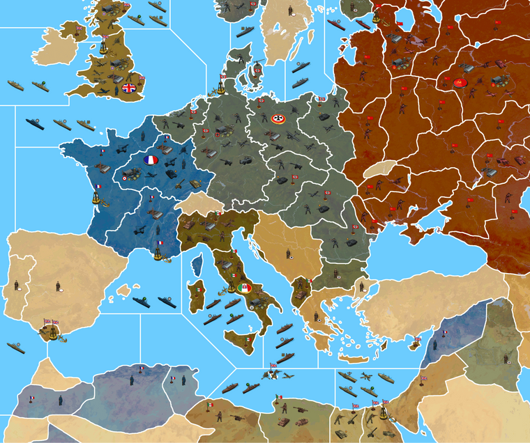
-
@black_elk
Looking clean and very good! (nods approval)Currently unit size is maxed at 125%, so you can get even more unit types or allies in the same TT without overflow.
-
@black_elk Looks way cool ! The French guys look like they are getting ready to surrender lol
This Map is HUGE ! :beaming_face_with_smiling_eyes:
-
Right on!
Yeah I was wondering if there might be an upper limit on upscaling the units before we hit a snag. I guess that limit is 125% hehe
In a perfect world it'd be cool if the player could double the size of their units, since there's really not much difference between an upscale to 125% and an upscale to 200%, at least in terms of the fuzz you end up seeing.
Any size other than 100% and you'll see some blur, even rescaling with No Halo. Like it's just never going to look as good as it does with units at 100%, but the blur doesn't seem to get any worse the smaller or larger you go from there. Half as large, or twice as large, you basically get the same amount of blur. I honestly couldn't notice the visual artifacts from rescaling myself, unless the rescaled units and the 100% units are shown side by side. Then it's noticeable, but when you don't have anything to compare it to, they still look pretty good up to about 200%. It'd be nice if the units could just downscale automatically to fit the Calc or battle window rather than clipping, while still being extra jumbo for the map display, but sounds like 68px is as tall as it wants to let us go, so I guess that'll have to be the plan haha
-
Here are the baselines with the marshes fixed. I added another sz division for the Soviet arctic sea zones. Ebbe pointed out that they were kinda massive compared to the others haha, so I tried to fix that right quick, along with an island that got blacked out up there somehow. I'm not sure what else to do with it really in terms of the SZ subdivisions. I think what we have already is probably sufficient to get something interesting going there.
https://www.dropbox.com/s/xnvwl23sf092dia/Domination_1941_baseline.png?dl=0
https://www.dropbox.com/s/4740bj0l87sbb57/World_War_II_Global_1940_baseline.png?dl=0
Haha yeah I guess the French do sorta look surrender mode, compared to all the rest of the Infantry being attack stances now. I'll have to make a new Inf unit for them too, and China and Anzac I guess. The latter has a few dudes in Egypt, but I just clipped the detail there, cause I didn't get that far along with the units yet heheh. I still need to remove the roundels in the sticker set for those last few Nations.
I'll try to get that wrapped up tomorrow and then put a folder on dropbox at the end of the week, so we can start playing around with them.
Unlike the map, which still needs to be run through the utilities and built out, the units can be ported into the current build and used with Bung's map. The units will be rather smaller in the display with a map at 16816px compared to how they'd look on Bungs at like 7500px. Basically they'd appear twice as large on Bung's. The centers on the current G40 map at 48px too, so they probably look a little tight and may clip or have some foregrounding issues, but should still work for a preview. Like I've been using Frostion's with the roundels in my G40 folder and they still look pretty decent, even with the centers being a bit out of whack. It'll be nice to see some revamped centers on the new map though, with more room to groove hehe
For the Territory labels and production values, I'd like to just use the stuff that Veq and Bung put together for G40, since it's already done and looks pretty nice. But I think they will be too small with a map at 16816px, so I'll probably have to redo them all. It's sorta the same issue with the label graphics as it is with the units, the enlarged map means that the labels end up displaying smaller. Text that reads at like 36pt on Bung's map at 7500px, is going to look more like 14pt on a map at 16916px. I'm not sure, perhaps it's better to just avoid the labels and only show the PU values?
Text doesn't scale particularly well, and can quickly become illegible, unless the font is very clean and simple. For example it's easier to read the numbers next to the units when the map is at like 60%, than it is to read the labelling graphics. Since most people will probably play with adjustments to the mapview zoomed in/out, it seems like one of those things that might just end up being an eyesore and not really worth the effort. In the current map, the labels remain even with the map details turned off, since they're treated more like flags I think, with their own centers, not part of the relief. I'm not sure what the best approach is. I mean I'd like to have the labels, but only if it's going to look good hehe.
For the Domination map, I think we'd be better off not showing TT labels, but just the PU value graphics. Basically leaving the TT names for the hover-over w/ cursor. Otherwise I think the labels will just take up too much space and there'll be too much text everywhere. Instead of showing all the TT names individually, there might just be some larger regional labels so as not to have it too busy visually.
-
@black_elk said in Proposed Map: Domination 1941:
Instead of showing all the TT names individually, there might just be some larger regional labels so as not to have it too busy visually.
yea that seems a good idea

-
You'd have the color for the owner I guess but a Faction type logo thingy maybe ? So one would no original ?
Hello! It looks like you're interested in this conversation, but you don't have an account yet.
Getting fed up of having to scroll through the same posts each visit? When you register for an account, you'll always come back to exactly where you were before, and choose to be notified of new replies (either via email, or push notification). You'll also be able to save bookmarks and upvote posts to show your appreciation to other community members.
With your input, this post could be even better 💗
Register Login