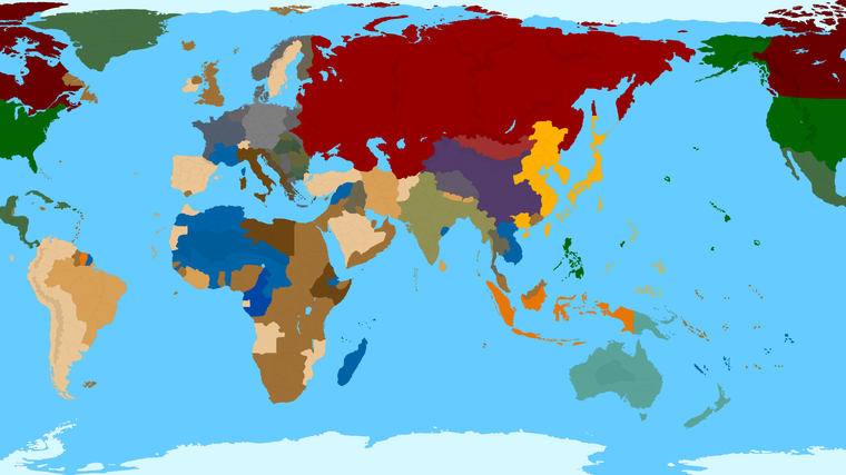
Proposed Map: Domination 1941
-
Here I had an hour free, so I blocked in Cernel's suggestions for those Soviet tiles, just so we could get it roughed out. I'll do the Italy and Balkans stuff tomorrow.
https://www.dropbox.com/s/3cpi8ksdcnohpgt/TripleA_4k_baseline_oceans_repainted.png?dl=0
-
@black_elk said in Proposed Map: Domination 1941:
ps. How do you feel about the region around Georgia/Dagestan? Hepps added in that mountain range, and I kinda like how it works for a road block. I feel like the whole Caucasus/Middle east could use a bit of a rework too down there, since that's still very WW1-ish and kinda cartooned out for that purpose probably. The way it is right now, that'll be a major chokepoint I'd think. I wanted to settle on the regional contours first, but I think Armenia/Syria/Iran/Iraq could all get a bit of a refinement, and then maybe that could play into how we divide the approaches there. We don't have any SZ yet, but I kinda like the idea of making the Black Sea/Caspian a bit more engaging somehow.
Well, the relative position of Georgia and Azerbaijan are clearly highly distorted, as Azerbaijan is realistically south-east of Georgia, whereas here it is north-east of it. I assume Georgia is actually representing Georgia and Armenia together (plus the Azerbaijan exclave to the south-west of Armenia). I suppose this map is sufficiently detailed rather to show Georgia, Armenia and Sovietic Azerbaijan as different territories. About that, also Dagestan (comprising Chechenya , I suppose) and Kalmykia can be drawn as separate territories, and I actually incidentally realized about that already in my previous split proposals. Anyway, the position of Azerbaijan relatively to Georgia is really not a problem and can remain as it is.
Much less acceptable, however, is the fact that the Caucasus mountains are touching Azerbaijan to the south-west of it. This makes blatantly no sense because (in reality) they actually delimit Azerbaijan on the north (beside a small piece of Azerbaijan which is in Europe). This means that the Caucasus mountains are largely misplaced and make little sense in general.
However, the impassables in this map (in general) are quite clearly far from realistic, as one can see from the mere existence of the Ural mountains (which are rather small mountains and much less of an obstacle than many other mountains like the Alps (and I'm not suggesting to add the Alps)).
Like, the fact that there is some sort of impassable barrier between almost the entire border between Mongolia and the Sovietic Union makes really no sense, but really almost all impassables I see make no sense. I'm sure they have been added merely to make the board more interesting to play on, with little concern to realism, so this is a map-making choice.
All this said, if the Caucasus mountains would be drawn in the right place, I can tell you that there are three main ways to move through them: through the coastline to the west of the Caucasus (where there are simply no mountains because they don't reach the Kerch strait), through the Darial Gorge and through Derbent (that is simply skirting the Caspian sea).
https://en.wikipedia.org/wiki/Darial_GorgeGenerally speaking, mountains have so many passes that you really need a much more detailed map than this one for them to make sense as impassables anywhere but maybe a very few cases unless you use them better to define crossed borders. By crossed borders I mean those borders that have a single point shared between two zones, like Central United States, Southeast Mexico, Mexico, Western United States in Global 1940 or a so-called "quadripoint" in real life.
https://en.wikipedia.org/wiki/Four_Corners_Monument -
@cernel Yeah I kinda had the same thoughts a few times hehe
The whole dilemma with this section at the center of the board, as opposed to the other regions/continents, is that you get all these weird North/South/East/West dismorphs. Basically it comes from englarging the surrounding SZ areas in most cases. I think it may be possible to upscale the Black Sea slightly (I already made it pretty large hehe) but then all of a sudden somewhere else will feel visually squished or just so off. I'd say the majority of compression is happening right there on the board. I trying to redraw Kazakhstan now would be a bit of a pain, cause of where everything else it now located, and so you almost need weird abstractions. I think that's also why Hepps prob added a few more blobs in various locations. The mountains in place, I left in place, but stuff added to the north is basically to stitch in what was missing over an inset. So I don't know. I kinda agree on the mountains.
On the other hand having sorta more random impassible just as visual/geometric type features is helpful. Ways to block a path, that aren't just "the Sahara" or whatever heheh. I kinda liked that concept, but it's definitely abstract. You know, like Elephants over the alps, there's probably a way no matter where it is. Upside I guess is that they could always be easily erased to flag back to more political boundaries, but I didn't see a strong reason to start erasing yet. Eventually I'd like to get something Kurt says is like "yep" that'll do, and then I'll save it out svg, then go back and carve it up into Global, or maybe make some alts for those older games, but I like the idea of it living as a game too. I think Domination has a nice ring to it, but really you kinda need two versions of the baseline, one that takes you up to WW2 and after, and another to maybe cover stuff more pre-20th century to WW1 interwar. The suggestion you raised about distance to Moscow vs Baku or the earlier point about distance from the German line to Paris via Belgium, is interesting. The only advantage to much smaller discrete tiles is starting ownership of TTs at a given date, but otherwise it's like yeah, do we really need danzig? I mean of course we need the Album, but I mean the tiny TT. Stuff like that, I don't know, if it's small enough it's easy to draw back in though. So yeah, sorta makes sense to default more to a distance "movement in turns" frame for some of this stuff. I think it probably makes sense to do a topo morph pretty soon for the mountains. Just to reshape if it makes sense. I tried to wing it, but I'd like to go back in and do something clean. Obviously you can't get an exact morph the exact way everything has been stretched, but you don't really need to. Like WOPR did for that v3, you can just isolate all the land (white) erase it to transparency, but keep the black and the blue solid. Then lay that over a roughly stretched topo morph and sorta push/pull till you get a relief that looks pretty decent that way if somewhat inexact for everything, but it still gives a good visual impression. You know with the units and decorative elements hidden, but I just mean like the visual sweep of the topo there. Kinda subtle and more backgrounded I guess, without the large flag transparencies or graphics stuff (that should be on a separate layer in the vector like the Dog suggested). But I'd like to achieve something like that, but at 16000 and for the Domination projection and that I could then make into the Global 1940 divisions or Classic or whatever.
-
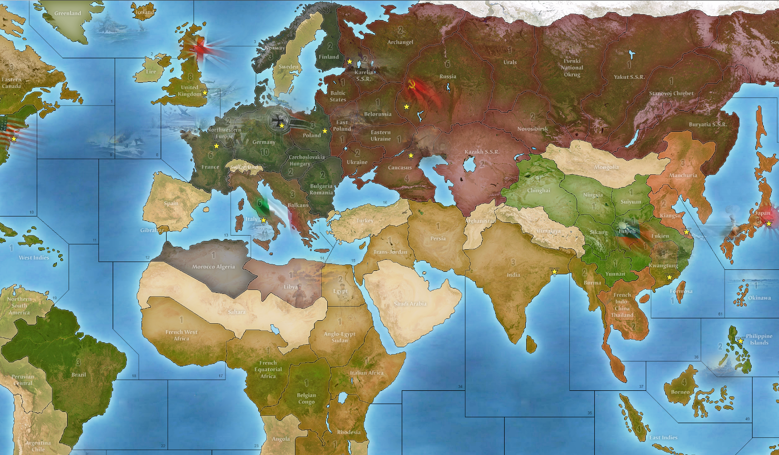
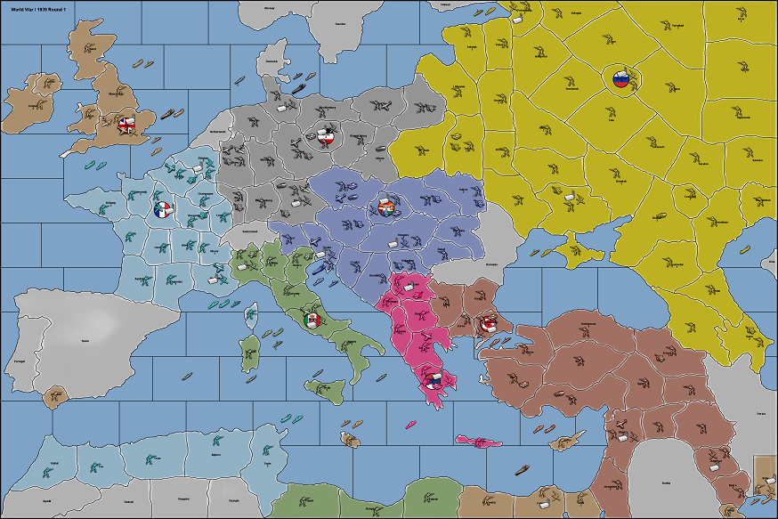
Ok so here's a quick pass on Italy and the Balkans. Obviously some stuff is a little weird from the general warp, but I tried to block it in a bit closer to WW2. For Italy there's a bit of a dilemma between deciding how carved up to make it. I like the general division along the defensive lines mentioned, since they aren't too far off from regional/river boundaries, in case of using a reference for other eras. But like further south, I wasn't sure if we wanted a few spots for Allied landings, to give it the Sicily invasion to Salerno type flavor? I guess with some SZ divisions you could probably dial that a bit more. But whatever, just trying to get a block in going hehe.
If you wanted to the Po line to split that Venetia TT more horizontally I guess we could do that, but it gets a little weird. Dividing Italy entirely by German defensive lines later in the war probably wouldn't be terribly helpful for maps in any other era, cause it's like a very specific point of reference there, as opposed to drawing provinces, but I guess this is a WW2 board now right lol. Anyhow, I'll let someone take a red marker to it, before I put in too much more work. It's kinda exhausting lol.

-
@black_elk I wouldn't split Sicily into two or more territories on this scale, the same for the already relatively small Albania. Similarly, maybe it would be better merging your Calabria and Apulia territories, merely on the consideration that they are now relatively quite small (so they have a dart of space for units placement). Also, the Bulgar Macedonia is too small a territory. About this, maybe I've been misunderstood: since here Jugoslavia is given as neutral, Albania and Bulgaria should not touch each other because that happened only after Jugoslavia was carved up. You may want to draw the internal boundaries of Jugoslavia as to represent such carving, however.
The Gothic line I guess is acceptable, even though it is drawn much more to the north of where it should be. If it is a problem of space, I'd say there's no need to show the Transimene line (so the two territories divided by the Transimene line may be merged).
I suppose you forgot to give Italy the Dodecanese.
-
@cernel Yeah I guess it really does depend on whether you want 40 or 41. The Balkans is such a headache heheh. OK so fewer divisions in Italy then.
I mean on some level, it's like you could just start slapping down random nodes and curves or something. Rather than having me draw it out for each iteration. I'm trying to think of a more expedient design for drafting.
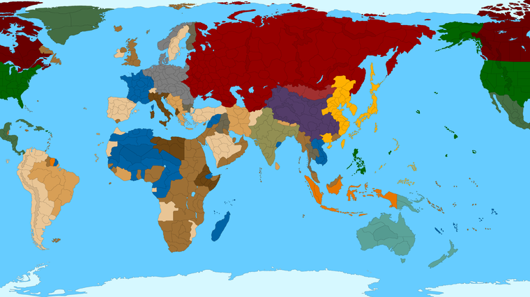
Obviously this would be somewhat simpler if we used a standard projection of any kind, but the downside there is the map would just be too damn big I think hehe. You'd be just scrolling forever. So I guess this is bound to be a compromise. I mean I can just break out the "<insert start date month/year>" for the rough political boundaries on a separate layer or something. But seems like what we need is kinda like Hex blob for the tiles, with smaller zones that are likely to be erased at a more midscale game. The paint job I did was not really a suggested start date or TT possessions, I just wanted to show the world colored in, cause otherwise it's easy to tune stuff out. So I used a vaguely global 1940 paint up lol. Kurt said 1941 though.
Good call! Yeah I'm sure I just missed with the paint bucket, so many tiny blobs heheh
-
BTW Tibet was independent. Japan controlled all Kuril islands but North Sakhalin was belong to the Soviets. I see Mozambique is divided. Also it is better to give Burma to the Raj.
With there are so many Allies nations. Is one piece Japan really the best option for gameplay? I doubt. For example WaW would be really broken if Japan was unified. One piece Japan might be unstopable in this scenario. Plus it would probably force the US investing only European fronts. I would like to learn the opinions of the community.
Also what about the Soviet-Japanese war? Should they really at war with each other?
-
@schulz Good eye! hehe I guess I should probably repaint it more 41-ish in some other spots too. Just so I don't forget where we're supposed to be headed with this stuff, or keep missing the same spots with the paint bucket lol. This is like halfway there-ish I guess. Not sure how one wants to assign control in the Balkans, whether all to G, or some kind mini faction, or like who annexed/occupied what and when hehe, but anyway, did a few colors to get a better feel there. More shades then we need, but just to give a quick pass. I'll wait till we got a start date before finishing that out.
Not sure on the Japan Q. To me it would depend on the forces I guess and the SZ design. For NAP with the Soviets, I kinda like total war conditions there, but it's always problematic. I've never found a great solution that hums for me. I think it would be nice if Russia could defend itself at least though, just so it doesn't go too Classic up there lol. On the other hand, towards the endgame I kind of enjoy if Japan can mix it up. So again, hard call. I think the focus for the IJA should be in China though. I mean that tied down what, like a million dudes? There should be incentives not to galivant up north as Japan on account of that, provided China doesn't just get flattened immediately like in all the official A&A boards heheh.
Oh also, while thinking about the start date, I think it's possible (depending on the turn order sequence) to cram a fair amount into the first round. Like if you wanted Europe to feel more early 41 and the Pacific to feel more late 41, I think that's doable, provided Japan and the US go at the very end of the sequence. Like if you wanted to design a more Barbarossa thing over here, but a Pearl Harbor vibe over there, just make sure the turn order sequence feels kinda right for that I'd say.
In 41, Italy doesn't have much presence in East Africa, if any, so the scramble there would need to get fixed. I showed roughly where Free France would start, if all the rest of the Blue was Vichy (to Germany in Africa/Med and Japan in Indochina). I think we could still keep a bluish kinda tint to it maybe, like in the reliefs, to get that point across, but easier to just assign control to G, so they're more dynamic. If the Blue was starting G ownership, it would allow the British and Americans more zone to expand. I'd do the same in France, like everywhere until Paris is liberated. Control of spaces outside the main core Capital zones should probably be starting owner Attackable Neutral, which would solve a lot of issues with the regular A&A games and liberation weirdness. In other words when Torch goes down, or D-Day, those TTs in N. Africa or Normandy should go to control of the conquering power, rather than returned Free France. Better for the gameplay once the Allies cross the Atlantic I'd think.
For total number of player-nations/factions, I don't think we need a crazy gang of factions overall, such that the sequence takes forever, but I think another smaller Axis faction for parity with the Allies could potentially be fun Again the turn order sequence is pretty important to make that work/feel right though. Basically to avoid a bunch of can opening nonsense. I did the colors more for style than a suggested number of factions here.
-
Yes. Japan having a very easy time to steamroll China and Asian Russia is very big problem for a WWII scenario. It is really need to be addressed.
-
@schulz It is very easy to address, actually. Under any realistic representation of production values, Japan is going to be so weak that can be handily crushed by using only a quarter of the United States power against it. The only way Japan can do anything like you describe is if you are making a map in which it has a production riduculously above any historical values of any kind.
Both Japan and Italy were not the first world countries they are today. Today Japan is the third richest country in the world (about a quarter the GDP of the United States) and Italy has a higher GDP than Russia. Back in WW2, they were backward and scarcely industrialized countries. Both Japan and Italy had about the same productivity per person, but Japan was stronger because of having more persons in Japan and a more valuable empire. In either country, most of the population was still living almost like in the Middle Ages.
-
@cernel If Japan and Italy is going to be weakened, wouldn't Germany need to be unrealistically super strong in order to have a relatively balanced game? With realistic production values, probably the Soviet Union would be designed to doomed to fall.
There is actually another method. Make China impassable and no Japanese-Soviet war. No war with China and the Soviet Union means Japan can afford to have less production values.
-
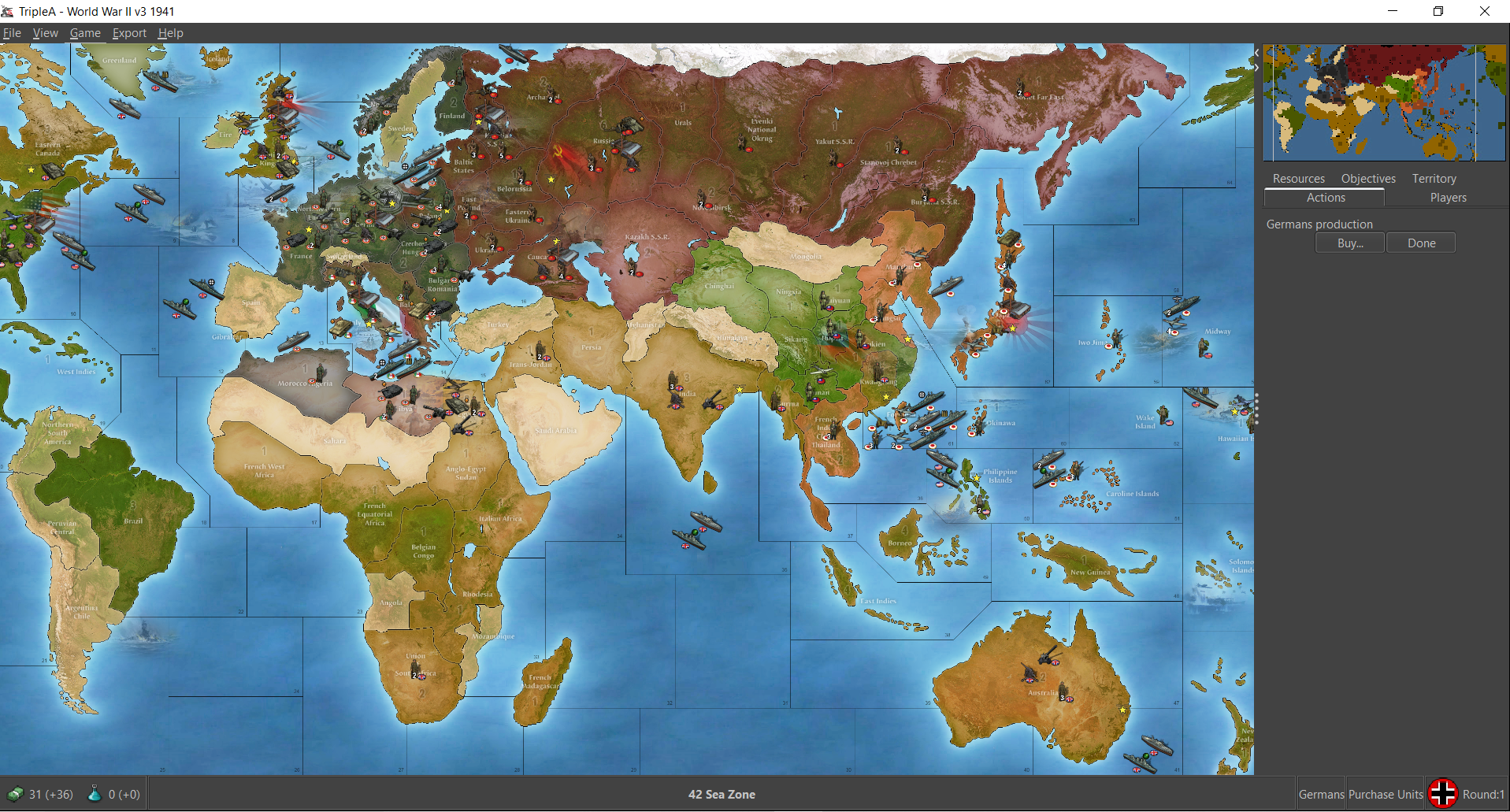
So earlier I mentioned that is relatively easy to add circles back in, once we know what's what.
Here's a rough example of how that might present, using circles at 250 for the Capital spots.
As always, it looks a bit weird doing that for Italy for some reason, although at 250 the circle just about lands where the Lines would be hehe. I slapped some fast flags down real quick just for flavor.
I'm not opposed to the circles in principle. I just think if using them, then there needs to be some kind of rough parity around the map, so it doesn't look oddball only having them in a very few places. Another option would be to do some beefy circles like this for capitals but a few smaller circles elsewhere for other key spots that make sense. Not sure what look people prefer, but just for a quickie thought I'd throw something together. I think this looks alright myself, but I don't know what others would dig lol
https://www.dropbox.com/s/0zrfcz78w7ucqi7/TripleA_4k_flags_with_circles.png?dl=0

-
@schulz There are Europe-only maps, like NWO, Europe and Europe 1940. A realistic global map would be merely like an Europe-only map with also a Japan that has some minor impact, since the war was indeed over 90% decided in Europe alone: Japan was just a minor distraction.
If you can balance an Europe-only map, you can take that map, add Japan, India, Australia, China and make the United States and the Sovietic Union a little stronger (China, India and Australia together alone should already be about as productive as Japan but militarily weaker at start game). Any other additions are next to irrelevant.
-
@black_elk said in Proposed Map: Domination 1941:
So earlier I mentioned that is relatively easy to add circles back in, once we know what's what.
Here's a rough example of how that might present, using circles at 250 for the Capital spots.
As always, it looks a bit weird doing that for Italy for some reason, although at 250 the circle just about lands where the Lines would be hehe. I slapped some fast flags down real quick just for flavor.
I'm not opposed to the circles in principle. I just think if using them, then there needs to be some kind of rough parity around the map, so it doesn't look oddball only having them in a very few places. Another option would be to do some beefy circles like this for capitals but a few smaller circles elsewhere for other key spots that make sense. Not sure what look people prefer, but just for a quickie thought I'd throw something together. I think this looks alright myself, but I don't know what others would dig lol
https://www.dropbox.com/s/0zrfcz78w7ucqi7/TripleA_4k_flags_with_circles.png?dl=0
@black_elk I'm personally not a fan of simple circles but for anything which has too little space for placements, but I'm not strongly against them.
Yes, the circle in Italy looks quite bad and, like Tokyo, here and in WAW, doesn't make much sense, because the city was very much next to only one of the seas (in case of Rome, the Tyrrhenian), so what does it mean naval bombarding Rome from the Adriatic or naval bombarding Tokyo from the Sea of Japan?
However, the circles for the capitals match the big roundels nicely, so that is a plus.
This said, I'm not sure what the Indian circle is representing, but New Delhi is not there (this beside the fact that Calcutta was more important).
As for the Sovietic Union, it may be good having a circle also for Leningrad (to have a big territory in a cleaner way than enormously distorting the territory) and for Kuybyshev (which was the back-up capital of the Soviet Union had Moscow fallen). I suppose Moscow, Leningrad and Kuybyshev can all be capitals of the Sovietic Union, in the sense that nothing capital-related would happen before all three are lost (that is the TWW way, not the WAW way).
However, in cases like the United States, Canada, Australia, India and Italy, there is the problem that the capitals are not the most important cities, so you have an economic capital and a politic capital, and usually the economic capital is more important. For example, it is certainly economically worse for Italy to lose Milan than to lose Rome. A similar observation can be made, mutatis mutandis, for, respectively, New York and Washington, and so on. This is particularly extreme in case of Australia, where the capital is economically next to irrelevant and there is not a single undisputed economic capital.
-
@cernel Yeah, all that makes sense, and then there's the added downside that if someone wanted to go back in later and change something, and you have a bunch of circle stuff that needs to be erased, that's a total chore. I'm not a really a fan. They might be expedient, but also a crutch. I think the cons sorta outweigh the pros, when it comes to circles hehe. Better to do it up without them I think.
Oh also, just since we're on the subject, it might be nice to just nix the whole concept of capitals entirely. Almost all of the gamey distortions in the A&A endgame come from the capital capture dynamic and looting the purse there. If that aspect of the game didn't exist (or was changed sufficiently) perhaps a more interesting and historical endgame could materialize.
-
@black_elk
My 2p, I prefer non circles, so just a TT shape for me.Id prefer Tokyo to be only accessible from the southern coast.
Also Im planning for VCs for Capitals, Industrial Centres and Oil Reserves and the like, so lots of VCs, if that helps.
-
@thedog Sounds good to me. So circles are out, by popular decree! hehe
On my next pass, I'd like to erase all the mountain ranges too I think, and just do some political contours there to see how it feels. We know where they'd need to end up for Global and the like, but I'm not sure we'd need that sort of stuff for more divided map like this one, for all those reasons mentioned on the previous pages. I find them sorta visually distracting too, the more I look at em, so I think they should probably just go. Like the circles, they could always be added back in later if someone wanted. I can save a separate draft with those features remaining, but I sorta feel like it's up to us to curate best practices for the design on that one. There's gotta be a better way to create choke points or block fighter transits, without having to move literal mountains, I mean right lol.
-
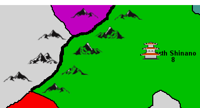
@black_elk
You have probably seen the method used below, but just in case you have not. A thick black line represents an uncrossable mountain range. It's easy to add later and maximising unit spaces, but it does not look good.
The image was taken from one of my early attempts at a Samurai map.
-
BTW I have drawn Paris connections like this way;
-
Dear TripleA Community,
may it be a better idea to redraw the passable territories on the map in key areas (Western Front, Eastern Front, Mediterranean, North Africa, China and South-East Asia) in more equalized dimensions?
For example, 1 territory is roughly 175x175 km. If more detailed political ownership is desired, than 100x100 km. or 150x150 km. or 200x200 km. or 250x250 km. etc. But important is roughly equalized dimensions for all territories to avoid geographical distortion.
To my mind this kind of geographical realism is better than administrative or political borders as the game is mostly played through major nations and all minors are always within their correspondent majors.
For example, to redraw all the borders using territories sized 175x175 km.
Why?
From Rome (Mediterranean coast) to Pescara (Adriatic coast) is 175 km.
From Pisa (Tower of Pisa, Mediterranean coast) to Ravenna (Capital of the Western Roman Empire, Adriatic coast) is also 175 km.
So, Italy is roughly 175 km. wide.Also, Japan is roughly 150-200 km. wide, and it seems that 175x175 km. territories are better to represent more equalized dimensions of territories in the game key areas (Western Front, Eastern Front, Mediterranean, North Africa, China and South-East Asia) than 150x150 km. or 200x200 km.
Therefore,
A-B (… km.) represents roughly … territories 175x175 km. including A + everything between + B:- Taranto-Milan (860 km.) represents roughly 5 territories 175x175 km.;
- Dunkirk-Marseille (890 km.) represents roughly 5 territories 175x175 km.;
- Paris-Berlin (also 890 km.) represents roughly 5 territories 175x175 km.;
- Berlin-Vienna (525 km.) represents roughly 3 territories 175x175 km.;
- Vienna-Triest (345 km.) represents roughly 2 territories 175x175 km.;
- Berlin-Istanbul (1750 km.) represents roughly 10 territories 175x175 km.;
- Leningrad-Stalingrad (1550 km.) represents roughly 9 territories 175x175 km.;
- Stalingrad-Baku (1020 km.) represents roughly 6 territories 175x175 km.;
- Kiev/Kyiv-Stalingrad (1040 km.) represents roughly 6 territories 175x175 km.;
- Minsk-Odessa/Odesa (880 km.) represents roughly 5 territories 175x175 km.;
- Shanghai-Shenzhen (big city near Hong Kong) (1220 km.) represents roughly 7 territories 175x175 km.;
- Shenzhen-Hanoi (870 km.) represents roughly 5 territories 175x175 km.;
- Hanoi-Imphal (Burma campaign) (1280 km.) represents roughly 7 territories 175x175 km.;
Moreover, due to much worse weather conditions and a weaker transport network, the Eastern Front should obviously have more territories per 1000 km. than the Western Front.
But even if we take pure geographical dimensions, it seems that the Eastern Front should have much more territories, be much wider and deeper and therefore have different playstyle:
- more Blitzkrieg playstyle on the Western Front;
- strategic width and depth on the Eastern Front;
The same applies to Chinese and South-Pacific Front where some important engagements with Japan forces took place.
Currently most TripleA maps:
- overrepresent Western Front and underrepresent Eastern Front by trying to somehow make them equal. But they are not equal.
Mild weather, good infrastructure, and much smaller frontline suitable for perfect Blitzkrieg on the Western Front vs severe weather, weak infrastructure and 3-4 times wider and many times deeper frontline on the Eastern Front suitable for more strategic playstyle.
-
overrepresent Latin America, Africa, Middle East, Central Asia and Siberia. Maybe I am too old to understand the importance of these regions for any TripleA map especially if these maps leave little place for naval warfare.
-
underrepresent naval areas (Battle for Atlantic, Pacific campaign, etc.) and make them too narrow for naval warfare with aircraft and carriers.
As far as I understand, aircraft from the carriers or land bases should have at least 2 squares advantage per move over any ships and submarines.
Therefore, carriers and aircraft would always keep at least 1 square distance from ships and submarines. Biggest naval guns fire on 40 km. distance (Jamato BB) whereas aircraft can attack from 400 km. distance (destruction of BB Jamato) and always keep carriers out of range.