Axis Ascension
-
@rogercooper I was thinking the same too. I will definitely add them.
-
I would like to mention about two semi-bug.
-
If an unit cannot be bough and doesn't present in the map, they don't appear in calculator. I do believe they should appear in any situation.
-
If incomes are collected at the start of rounds, it is not possible to reduce enemy incomes by bombing their factories. Because they already start with 0 income.
-
-
- True, but they will also be unable to repair anything with a cost. Short of having negative income, although not ideal, the current situation is a reasonable balance.
-
Yeah it's kinda rough, particularly the battle Calc thing. The tension is reflected in the tagline: "Community built maps, Axis and Allies game rules." The last part being the sticking point hehe.
TripleA has been bent pretty far to do some cool stuff, but there are things it couldn't really have anticipated when it was being put together. For example the A&A phase order is something that hasn't changed much since the thing launched in the mid 80s. The one big thing that happened was that a damage/repair aspect was introduced to SBR in v3 the ruleset. Prior to that bombing just removed money from the opponent's purse directly, with no intermediate input from the player, or any choice there about whether or not to repair, cause it just didn't work like that back then in A&A.
Similarly, units being in the game, but not part of a universal purchase roster, is something that would have been hard to see coming. Outside of the Iron Blitz PC translation of Classic technology advances, or China post v3, the only A&A game to mess with that idea was A&A Pacific in the early 2000s, with the introduction of the USA's Marine unit. And that one was sort of a one off.
For my part, I find that having different unit rosters for different player nations makes a game much harder to parse at a glance. It means you have to be familiar not just with your own unit roster, but all the unit rosters of every other player nation, in order to play effectively. It can work alright if all you have to worry about is one nation getting Marines, but the more units like that you have, the harder it is for the player to make sense of what they're seeing displayed on the board when they launch. Especially if going in cold.
I would caution against designing the balance of a scenario around features that are busted, or which don't currently exist, cause there's no way to know when someone might be able to address that stuff. Like it could be a while, if ever, so just something to consider when planning out the broad strokes.
-
I've just removed SBR from my game due to having a diffculty to figure out the correct cost of bombers.
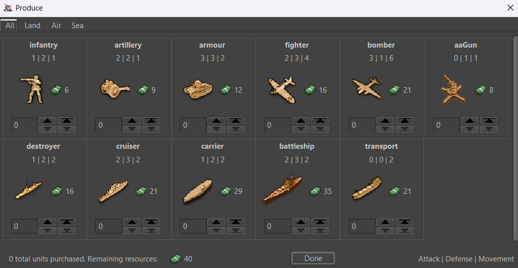
As you can see, naval invasions are harder in here due to expensive transports and enhanced effectiveness of air units over the naval ones. I just didn't want SBR OP.
-
Is anybody interested in to playtest?
-
@schulz im down
-
@ubernaut I'm planning to upload on Github after I can find a better/original name and relief tiles for the game.
-
@schulz keep me posted
")
-
https://github.com/triplea-maps/axis_ascension
Balance suggestions are welcome.
-
I would like to re-integrate bombers but after figuring out the correct cost.
-
A more interesting set-up may be needed.
-
-
No Submarines? Germany starts out with 4 and more can be added, to Germany, through triggers, but no player can purchase them.
The idea of not being able to use a captured factory is nice, and factories/harbors cannot be produced. But the axis starts out with 3 each and the allies have 10 factories and 11 harbors. So all the axis production comes for their capitals. Germany and Italy are well protected, but...
Sea zones 140, 148 and 149 have no starting units, a lone infantry stands guard and there are only 2 transport, each costing half of Japan's starting PUs to replace, also The_United_States may receive free destroyers in the pacific.
Advantage Allies!
Cheers...
-
-
I've had a trouble to find the correct cost for submarines.
-
I'm considering giving Japan a harbour in Indochina, Malaya or Truk. Japan can be further buffed too if Axis looks like disadvantageous.
-
-
Could anyone put the map into the repository?
-
@schulz It is in the repository. The problem is that the repository is not working correctly.
I have been continuing to upload scenarios for months while waiting for the problem to be fixed.
-
what's wrong with the repository? Not that I have the access or knowledge of that area to fix it, just curious what the problem is.
-
Older maps can be downloaded within TripleA, but newer ones cannot.
Im only bothered about 2.6 map repository as it works differently to 2.5
-
Hi everyone, it's been a while.
The scenario's preview image is incorrectly displaying the big world scenario, but I had already added the correct one.
https://raw.githubusercontent.com/triplea-maps/axis_ascension/refs/heads/master/preview.png
How to solve the issue?
Thanks.
-
@schulz I put a change in that should fix it.
-
@rogercooper Thank you.
Hello! It looks like you're interested in this conversation, but you don't have an account yet.
Getting fed up of having to scroll through the same posts each visit? When you register for an account, you'll always come back to exactly where you were before, and choose to be notified of new replies (either via email, or push notification). You'll also be able to save bookmarks and upvote posts to show your appreciation to other community members.
With your input, this post could be even better 💗
Register Login