Axis Ascension
-
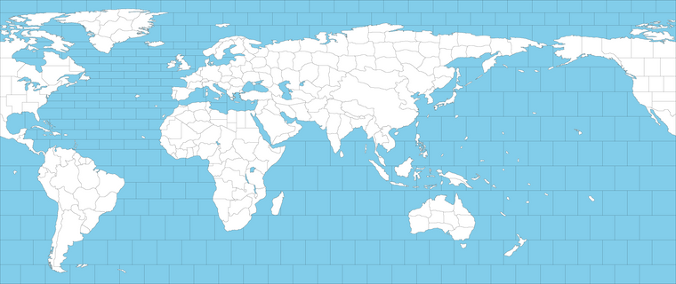
-
I'm planning to have only 6 nations and relatively small unit roster to have faster gameplay.
-
No territory is impassable other than neutral nations. No Russo-Japanese war. Probably no UK-USA units are allowed in the Soviet soils.
-
V3 rule-set.
-
No tech, diplomacy or national objective.
-
Jun 1942 is probably starting date.
-
Drawing is still not finished. Some areas still can be enlarged to fit more units.
-
-
@schulz Are you sure about the name of the game? I assumed this was an Europe theatre non-global game.
-
@cernel I have no idea about the name of the game yet. Maybe Fortress Eurasia or Fortress World?
-
@schulz Well, Fortress Europe mainly refers specifically to defending Axis Europe. I'm not seeing it morphing well into anything else.
-
@schulz looks like u used the same basemap i posted years ago looks cool
-
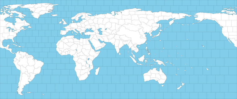
I have just redrawn Atlantic sea zones. Probably naval units will need to have 3 movement power.
-
@schulz said in Fortress World 1942:

I have just redrawn Atlantic sea zones. Probably naval units will need to have 3 movement power.
Are you using the equirectangular projection?
Why is free Cina not split?
I'm thinking you can split each of the two territories of occupied China into two or more (especially Manchuria).
I know it is really small, but I cannot imagine any decent WW2 game not having Italy split into at least two territories. The south of Italy was taken in 1943 and the north in 1945, so having to take all of Italy at once or not at all is really beyond over-simplified unless you are using contested territories in a way that opposing forces can stay in the same territory without attacking each other for a long time.
-
@cernel Yes, it is equirectangular projection. I've found equal area projections not visually appealing.
I am thinking not to add China at all (although I am still not sure) and making unoccupied Chinese territories impassable. But I really don't want Allies having more countries than Axis. If there will be China, I will probably split Japan to represent Imperial Japanese Army and Imperial Japanese Navy.
Yes, Italy can be splitted but what about the others? Should Germany and Japan be splitted as well considering limited spaces for units?
-
@schulz said in Fortress World 1942:
Yes, Italy can be splitted but what about the others? Should Germany and Japan be splitted as well considering limited spaces for units?
I would not split Japan on this map just for placement space reasons.
As for Germany, it is somewhat interesting to split it along the Soviet and non-Soviet occupation zones on Victory Day, but, in a game, beside having some very random and very impactful tech system (for example, Hitler gets the athomic bomb in 1945, nukes everyone and wins) you would never reach that point under anything close to those conditions (because any normal person would have surrendered the game a lot earlier). The Axis winning the game with Germany conquered implies having a ridiculous Japan: historically there is no way Japan can conquer the world after Germany is taken by the Allies.
On the other hand, graphically, a single undivided Great Germany right in the centre of Europe looks cool. Moreover, it offers a lot of space for units.
The conclusion is that I don't think I've a preference on whether or not splitting Germany in a small map like this one.
-
@cernel The resolution isn't very small actually. For example there are 15 placement spots for Germany.
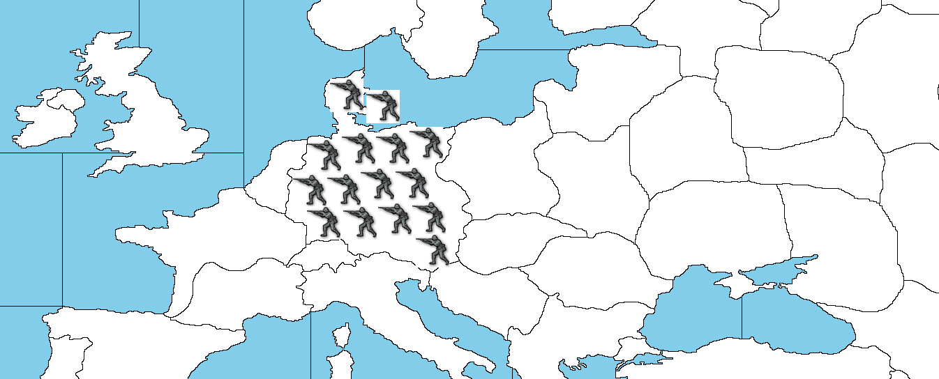
I can see the only benefit of splitting Germany is making the map suitable for cold war scenarios.
Japan can easily be enlarged to have more placement spots too. Japan has 10 placement spot.
But Italy doesn't have much space. Also there is just not much reason to invade Italy rather than France from gameplay perspective.
-
@schulz One piece Italy just makes no sense in every WW2 game (with the partial exception of the ones allowing for contested territories) because, then, you have either to take all Italy at once or not at all, and neither of these situations ever happened, not even if one would say that a round is one year. The lack of Sicily is also a pretty big deal, but I guess you can have Sicily and south Italy together because they were both taken in 1943 within a few months (the invasion of Sicily started on 9 July and Allied units entered Naples on 1 October).
If Italy is in two pieces, the border should represent the Gustav line. This should give a decent amount of placement spots to north Italy but very little to south Italy. You can cut a box somewhere for south Italy or something.
-
@cernel I guess combining of Southern Italy and Sicily can give 4 placement spots. 2
I am still not sure about splitting Germany, adding Normandy, Sahara Desert, China, Soviet-Japanese war etc.
-
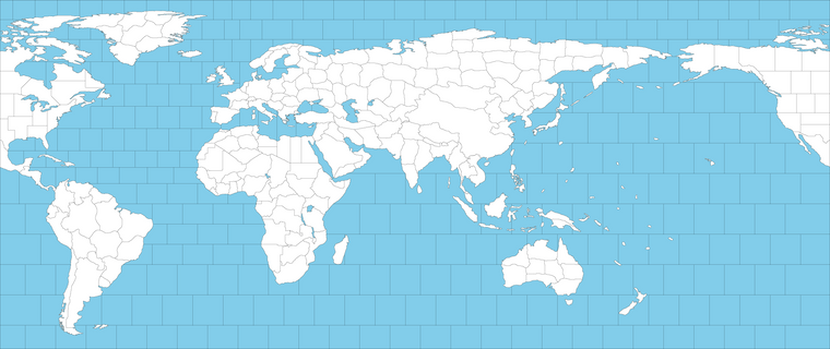
Could anybody slighly shrink American continents and Greenland proportionally? I just don't know any easier way. So I will be able to freely delete all of the top and bottom sea zones without preventing the current sea routes.
Here is the original one.
-
@schulz
I tried both a high res and the lower res (4096x1724 both versions are too complex for Inkscape autotrace to work, it crashes, so its not a quick fix.Why not just remove the top tileset and post the png again? I will try again tomorrow.
-
@schulz @thedog you may have an easier time pulling a baseline from this one
https://commons.wikimedia.org/wiki/File:BlankMap-World-Equirectangular.svg
You'd have to redraw some of your borders or re-paste the sz tiles etc, but at least it's already in vector.
I think the simplest approach is to pull the baseline at your desired scale, or morphing the scale on the Americas or whatever. Export that as a raster (like PNG) then bring it into GIMP to do your borders at 1px with no antialiasing. Using the magic wand you can select a tile, expand that selection by 1px and fill that with black, then shrink by 1 px, fill that with white, and you'll have the desired 1px borders. But like doing that for each Tile individually.
Otherwise what happens is you will get broken lines and have to go in and manually add pixels or redraw borders, which is basically what I've been doing with that other map. It's tediuous, and I wish there was a better solution.
Alternatively, if you just want it hard and fast I could rescale and fill the entire landmass of the Americas so that is at 1 pixel, but you'd have to retrace the borders of the smaller TTs. To do that you can basically create two layers, and lay your trace on top, like as if using a lightbox, then remove the bottom layer when you're done and you'll have something that works with the utilities.
-
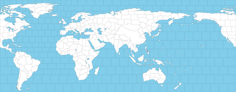
I've just managed to shrink S.America and got rid of all useless bottom sea zones.
Northern top sea zones are harder to get rid off. Because I also want to have naval connection on the top of Greenland. The only way to achive this severely shrinking Greenland and Canadian Islands. I've tried it but unfortunately it didn't look good.
It sounds dumd but I do really care aesthetic and I would like to keep land masses and distances realistic asap.
For example if you compare this map with my first map. I've actually enlarged Europe to have more room for units. But probably I am very close to natural limits.
-
@schulz said in Fortress World 1942:

I've just managed to shrink S.America and got rid of all useless bottom sea zones.
Beside the very late Midway carriers (which were not commissioned before the end of the war) and Montana battleships (which were aborted in 1942), the strategic significance of sea-moving south of South America is virtually zero in any historical WW2 game, so (rather than distorthing shapes for virtually no reason) I would suggest you cut whatever part of South America you feel is too down south, together with all the sea zones connecting the Atlantic with the Pacific south of the Americas.
I'm just not commenting about the northern sea zones and especially the ability to move north of Greenland beside saying that, in a equirectangular projection, moving horizontally is realistically faster the farther away you are from the equator.
-
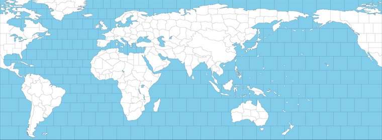
I've also cut the top sea zones and added Malta, Gibraltar and Hong Kong.
I would really like to keep south of South America for aesthetic purpose.
-
-
Do you think should Germany be divided? Dividing Germany will make a lot harder to defend W.Germany, E.Germany and France.
-
I am kinda annoyed with the fact that Germany usually isn't capable of reinforcing Norway with land troops which results very easy invasions from the British. What about making the Danish stratis canal? Germany will be able to keep a navy in the Baltic Sea more safely plus the ability of reinforcing Norway.
-
Do you think should Sahara Desert really be represented?
-
Is it better for all naval units moving 3 rather than 2?
-
What about merging Sardinia and Corsica?
-
-
For M3 ships, just depends what you're after I guess. In normal A&A gameplay, there are strong incentives for players to park it in safe harbors and when they move out to do so only at the max distance along the optimal/shortest path. M3 can sometimes create awkward shucks that encourage players to occupy otherwise disadvantageous Sea Zones, or for the purpose of blocking, but otherwise you'll end up with a lot of spots that are mostly transits. M3 will allow the USA to move into position with less of a delay (fewer turns to get where they want to go), but it will also give the Axis a big boost. Like allowing Japan to reach India in 2 turns rather than 3 or 4. Or for Germany to move a fleet from Holland to the Med in 1 move.
For Africa/Sahara, just depends if you want a vibe more like Classic or post Revised A&A games. In all versions of A&A the importance of Africa is somewhat amplified. I'd just be careful not to put too much money in play n down there, otherwise you'll end up with Sub-Saharan Africa as a major theater of operations. It's kinda hard to avoid that already, if the gameplay allows for Japan to bounce towards East Africa with ease, which M3 ships would make more pronounced. One option is to only allow the transports to have that kind of reach, and force the surface fleets to play catchup at M2.
For Germany as a single tile, it depends how you want the capital capture dynamic to work. Double hit amphibious assault is sorta the standard, though you can tweak that by changing the turn order sequence. You can also tweak stuff just by the production values, like how much you want Germany to be worth relative to France or Poland and such, or the major Allied spots. In standard A&A you usually get a dynamic where Germany can turtle and just tried out of that single capital tile during the KGF endgame, but not sure if that's something you want to replicate here or try to change?
Danish straits would probably be good, if you want to avoid a situation where the Allies nuke the Kriegsmarine and then just invade Poland to pressure Germany rather than France. This is what usually happens in most A&A games, because then the Allies can stack behind the Russians as well. Also the reason why the Allies tend to push Norway and creep towards the Eastern Front along that route so the can tripleA team Berlin, though no Anglo-Americans in the USSR would definitely change that. Basically you just need to make the Russians stronger to compensate I'd think.
Corsica could probably be attached to Sardinia. Most midscale A&A boards don't even show Sicily and Sardinia as separate spots, but just attach them to Italy. Again probably depends on how much money is involved. Like if those spots are worth 1 or Zero.