Flames and Steel (official thread)
-
AI does not look good at drawing maps, territories, and naming things. Like Krakow being connected to Konigsberg through the northeast while bypassing Warsaw makes no sense at this map's scale. Or Kiev bordering Krakow.
Also, for consistency, it is better to name every land territory with its biggest city, like Prague instead of Bohemia. Having impassable Pripet Marshes would be great, too.

The main issue I see with the map at present is that the borders don't conform with the outlines of the pre-war countries at all. Try to picture how things would look here If you were to dial the clock back to 1938. Who would get Silesia, for instance? Czechoslovakia, Germany, Poland? It's impossible to answer because that province is drawn over territory belonging to all three of them, and whoever you give it to leaves the other two messed up.
Or why I brought up the Posen vs. West Prussia example... Posen is Poznań, a city that was in Polish hands before the war started. But German Silesia actually extended past it to the south, between Posen and Bohemia. West Prussia is the territory on your map that's above Silesia, where Posen ought to be. And yes, when you're drawing the provinces at this scale, Danzig and West Prussia essentially belong in the same space, so you should probably just be using one or the other. So relabel West Prussia as Posen, and make Posen something like Brandenburg. But Brandenburg belongs above Saxony, not east of it... kind of a headache.

Meanwhile you've got Königsberg separate from East Prussia, but it's shaped so that its hooking down behind Warsaw, between Warsaw and Polish owned Bialystok. And Kiev is that oblong shape that cuts in Bialystok and Lwów, which was also Polish. And should Kiev really be a border province that Germany invades on turn 1 anyway?

And then Austria is just a squarish blob and it's fully east of Bavaria, when it should be extending between Bavaria and Venice.
The bottom line here is that there are too many issues to solve in just a couple of spot fixes. Figuring out how to draw the borders is just not something that AI is good at. Even with terrible art skills, if you spend a few nights on drawing things out yourself, you're going to end up doing a better job than it just because you have a spatial sense of where things should go in relation to other things that AI really struggles with. What AI might be able to do is take a map where you've hand drawn crude outlines of the borders with a black marker in MS Paint, and polish it up - refine the shaping and re-render it with the better quality outline style your current map has.
At the end of the day though, it's up to you what standard you want to hold yourself to. A map can still play well even if it doesn't look right, and if it plays well right now, I'd understand if you decided a substantial redo would be more trouble than it's worth.
-
I think @kurtgodel7 could perfectly fine go with these territories for the Eastern Front. All he needs is to redraw Poland and its surroundings for the 1940 borders. Tsarist-era names have to go, too.
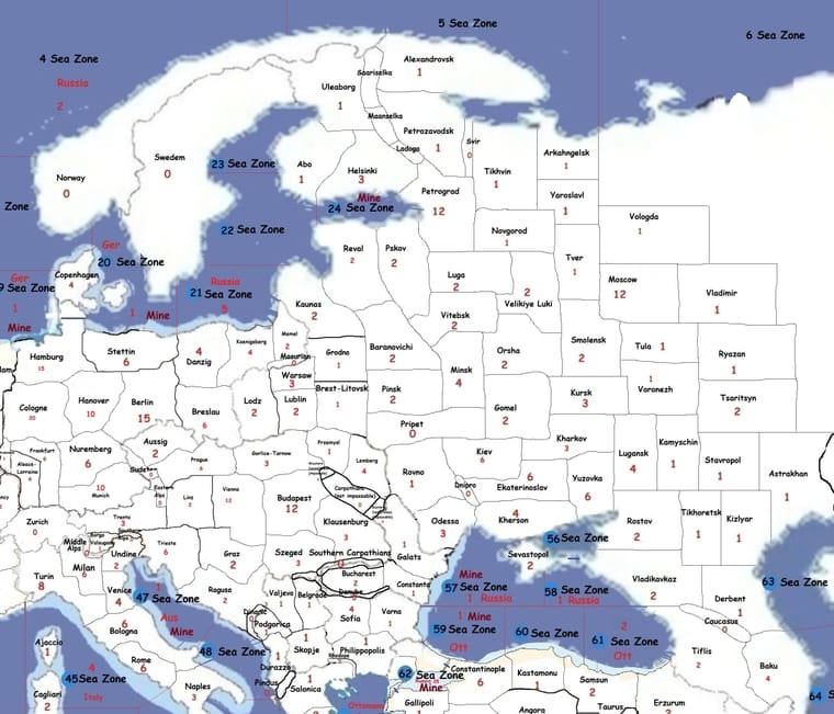
-
Map changes, including some border changes and the creation of the Pripet Marshes.
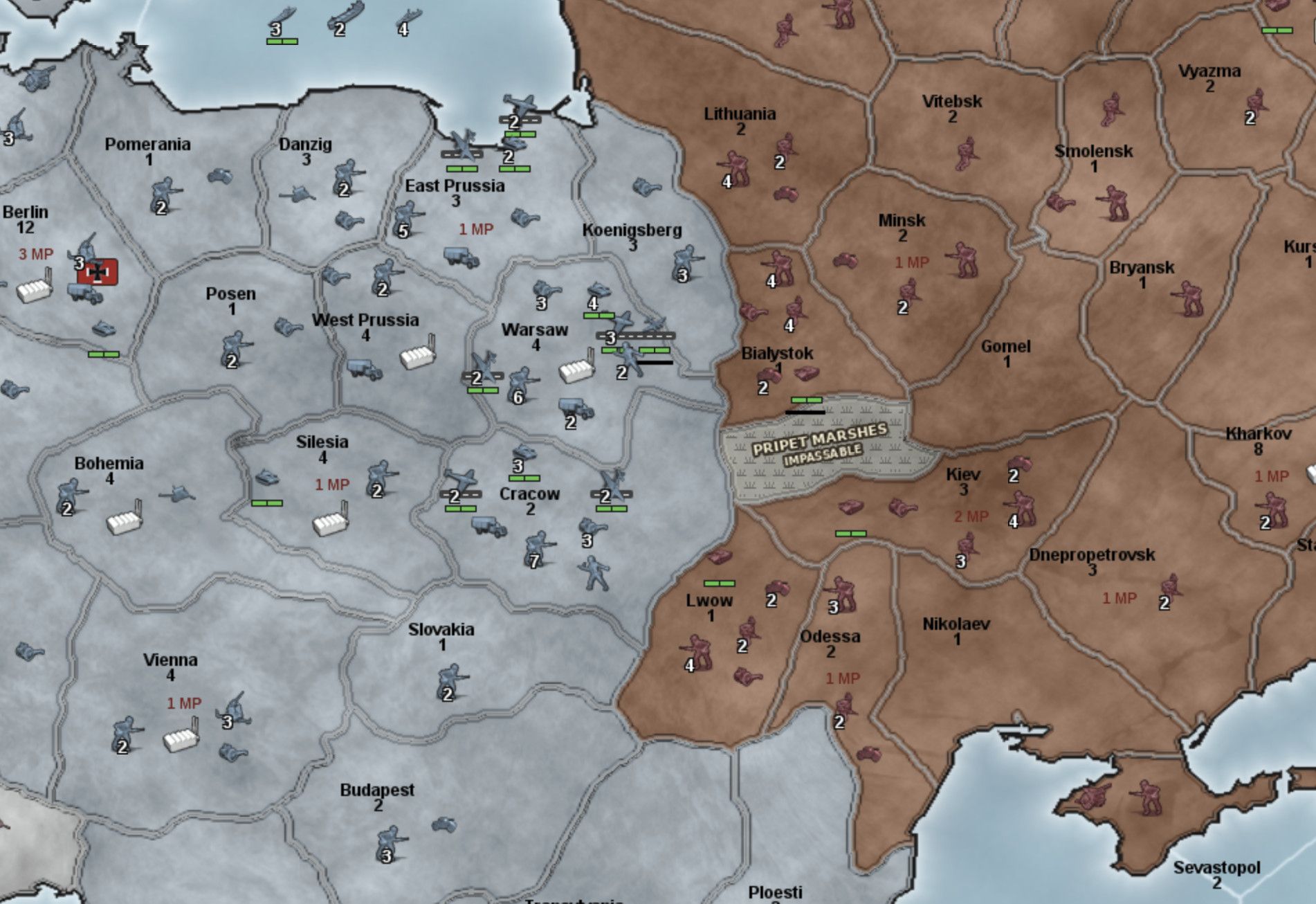
Specify to Claude that's 1941.
When either can be chosen, I've chosen one. For example, Wurttemberg can be called either Wurttemberg or Baden, and I've chosen Baden.
Also, you should be consistent: either have Koenigsberg and Wuerttemberg or Konigsberg and Wurttemberg. Your call.
(Current : New)
Koenigsberg : eastern East Prussia
East Prussia : Koenigsberg
Danzig : Danzig - West Prussia
West Prussia : Wartheland
Posen : Lower Silesia
Silesia : Upper Silesia
Pomerania : Pomerania
Bohemia : Bohemia - Moravia
Vienna : Austria
Bavaria : Bavaria
Wurttemberg : Baden
Saxony : Saxony
Berlin : Berlin
Hesse : Rhineland
Ruhr : Westphalia
Hanover : Hanover
Hamburg : Hamburg -
The main issue I see with the map at present is that the borders don't conform with the outlines of the pre-war countries at all. Try to picture how things would look here If you were to dial the clock back to 1938. Who would get Silesia, for instance? Czechoslovakia, Germany, Poland? It's impossible to answer because that province is drawn over territory belonging to all three of them, and whoever you give it to leaves the other two messed up.
Or why I brought up the Posen vs. West Prussia example... Posen is Poznań, a city that was in Polish hands before the war started. But German Silesia actually extended past it to the south, between Posen and Bohemia. West Prussia is the territory on your map that's above Silesia, where Posen ought to be. And yes, when you're drawing the provinces at this scale, Danzig and West Prussia essentially belong in the same space, so you should probably just be using one or the other. So relabel West Prussia as Posen, and make Posen something like Brandenburg. But Brandenburg belongs above Saxony, not east of it... kind of a headache.
Meanwhile you've got Königsberg separate from East Prussia, but it's shaped so that its hooking down behind Warsaw, between Warsaw and Polish owned Bialystok. And Kiev is that oblong shape that cuts in Bialystok and Lwów, which was also Polish. And should Kiev really be a border province that Germany invades on turn 1 anyway?
And then Austria is just a squarish blob and it's fully east of Bavaria, when it should be extending between Bavaria and Venice.
The bottom line here is that there are too many issues to solve in just a couple of spot fixes. Figuring out how to draw the borders is just not something that AI is good at. Even with terrible art skills, if you spend a few nights on drawing things out yourself, you're going to end up doing a better job than it just because you have a spatial sense of where things should go in relation to other things that AI really struggles with. What AI might be able to do is take a map where you've hand drawn crude outlines of the borders with a black marker in MS Paint, and polish it up - refine the shaping and re-render it with the better quality outline style your current map has.
At the end of the day though, it's up to you what standard you want to hold yourself to. A map can still play well even if it doesn't look right, and if it plays well right now, I'd understand if you decided a substantial redo would be more trouble than it's worth.
Claude said that nearly all your points were correct. The one place it pushed back was your assertion that AI could not do this task well. While it acknowledged the flaws with the earlier map, it expressed the view that it has the ability to correct those flaws.
Claude looked up borders from 1938, borders from June 1941, census data from 1910 and the 1930s, etc. This was all preparatory to a substantial redo of Eastern Europe's borders. A redo which your post inspired. Ty for pushing me on this.
-
I think @kurtgodel7 could perfectly fine go with these territories for the Eastern Front. All he needs is to redraw Poland and its surroundings for the 1940 borders. Tsarist-era names have to go, too.
I like the map you've posted. Ty for this.
However, there are two issues.
- I'm less than 48 hours into my usage week, and I'm already at 74% of my weekly usage. I was close to finishing the Europe redo when I saw your post.
- I'd envisioned Flames and Steel being roughly the same scale of map as Domination 1914 No Man's Land or World at War. The map you've posted implies a significantly larger map than that scale. If I adopt your map for Europe, I have to redo the world map to keep that same scale.
In earlier posts, I'd talked about being open to having multiple maps using my rules set. I want version 1 to have a map that won't intimidate someone who plays NML, WAW, or Global. But I absolutely believe there's room for something which uses the Flames and Steel rules, and which uses a large map like the one you've provided here.
Edit: your map inspired me to make Moscow six spaces from the German front instead of five. Two territories were split to achieve this. I think that six spaces away will allow the game to last longer.
-
Map changes, including some border changes and the creation of the Pripet Marshes.
Specify to Claude that's 1941.
When either can be chosen, I've chosen one. For example, Wurttemberg can be called either Wurttemberg or Baden, and I've chosen Baden.
Also, you should be consistent: either have Koenigsberg and Wuerttemberg or Konigsberg and Wurttemberg. Your call.
(Current : New)
Koenigsberg : eastern East Prussia
East Prussia : Koenigsberg
Danzig : Danzig - West Prussia
West Prussia : Wartheland
Posen : Lower Silesia
Silesia : Upper Silesia
Pomerania : Pomerania
Bohemia : Bohemia - Moravia
Vienna : Austria
Bavaria : Bavaria
Wurttemberg : Baden
Saxony : Saxony
Berlin : Berlin
Hesse : Rhineland
Ruhr : Westphalia
Hanover : Hanover
Hamburg : HamburgThe new map of Europe
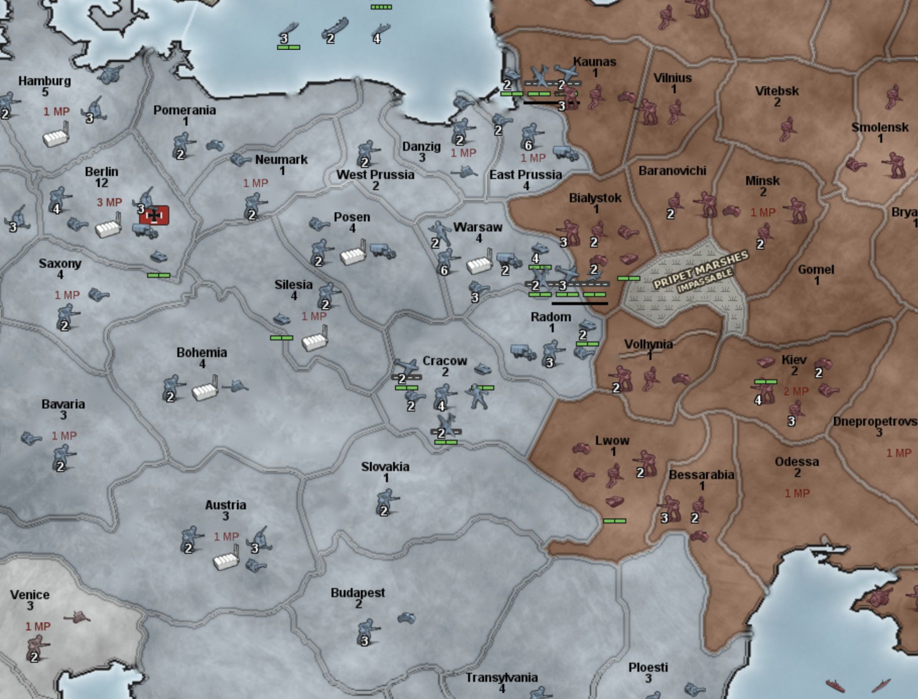
I was doing this while you were creating your list of names. I will hit Claude with that list. But if the new shapes inspire any thoughts about name changes lmk.
-
@KurtGodel7 Wait then. I'll make the new list based on the new map.
-
The new map of Europe

(Current : New)
East Prussia : East Prussia
Danzig : Danzig
West Prussia : West Prussia
Posen : Wartheland
Silesia : Lower Silesia
Pomerania : northern Pomerania
Neumark : southern Pomerania
Bohemia : Bohemia - Moravia
Vienna : Austria
Bavaria : Bavaria
Wurttemberg : Baden
Saxony : Saxony
Berlin : Berlin
Hesse : Rhineland
Ruhr : Westphalia
Hanover : Hanover
Hamburg : Hamburg -
@KurtGodel7 The outlines for Hungary, Austria, Czechoslovakia, Poland. and Romania are a lot more coherent now. There's still a bit of weirdness with with how far north Bessarabia extends and Lwow curling around Slovakia, but on the whole this is a major improvement over the previous version.
-
The new map of Europe
(Current : New)
East Prussia : East Prussia
Danzig : Danzig
West Prussia : West Prussia
Posen : Wartheland
Silesia : Lower Silesia
Pomerania : northern Pomerania
Neumark : southern Pomerania
Bohemia : Bohemia - Moravia
Vienna : Austria
Bavaria : Bavaria
Wurttemberg : Baden
Saxony : Saxony
Berlin : Berlin
Hesse : Rhineland
Ruhr : Westphalia
Hanover : Hanover
Hamburg : HamburgClaude's take on this:
Posen --> Wartheland
Agree. That’s exactly Reichsgau Wartheland in 1941. It also matches “West Prussia” (Danzig–West Prussia), which already uses the 1941 German name.
Bohemia --> Bohemia/Moravia
Agree. It’s the Protectorate.
Vienna--> Austria
Already done in draft 100.
Silesia--> Lower Silesia
Disagree. German Upper Silesia is in it, so “Lower” would be wrong. Keep Silesia.
Neumark --> southern Pomerania
Disagree. Schneidemühl did become Pomeranian in 1938, but Landsberg and Frankfurt an der Oder were Brandenburg. Landsberg was the Neumark’s chief town. If a change is wanted, “Grenzmark” fits the Schneidemühl half better. Pomerania then needs no “northern”.
Wurttemberg --> Baden
Disagree. “Baden” would drop Stuttgart. The accurate name, Baden-Württemberg, dates from 1952. Keep Wurttemberg.
Hesse --> Rhineland
Disagree, mildly. It’s a mix, but Cologne, the heart of the Rhineland, is in our Ruhr territory. “Rhineland” would mislead, so keep Hesse.
Ruhr --> Westphalia
Either works. Ruhr is the name players know, and it covers Cologne. Westphalia is more “provincial” in style but excludes Cologne. I’d keep Ruhr.
I didn't like the name Bohemia/Moravia. Where possible I'd prefer for a territory to have one name instead of two. I asked Claude what a good one word name would be. It gave me the following.
A one-word name for Bohemia–Moravia. There’s no perfect one. The real choices:
Bohemia (my recommendation). It’s the usual English shorthand for the whole Czech lands, and it’s what most WWII games use.
Czechia. This is one word and covers both halves accurately. But in 1941 English it was rare, and it reads as the modern country’s name.
Protectorate. It’s historically exact, but it’s not a place name, and it would sit oddly next to Silesia and Austria.
-
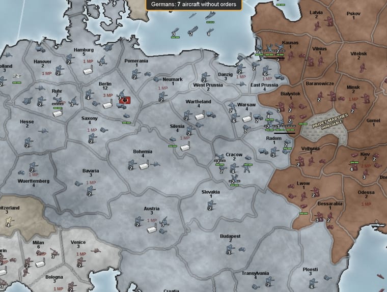
The latest iteration of the map.
-
Some of the new tech names
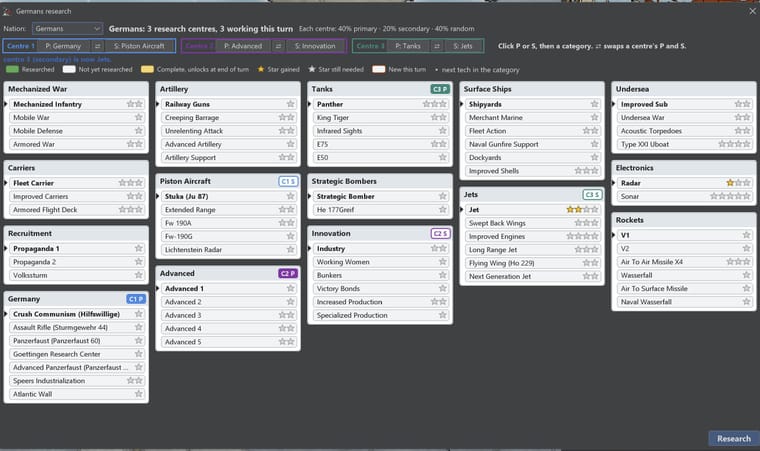
Advanced Panzerfaust is supposed to say "Panzerfaust 150" but it got cut off.
Normally you are limited to one bombardment shot per unit unloaded. Naval gunfire support increases that cap to two bombardment shots per unit unloaded.
-
America Pacific's tech tree
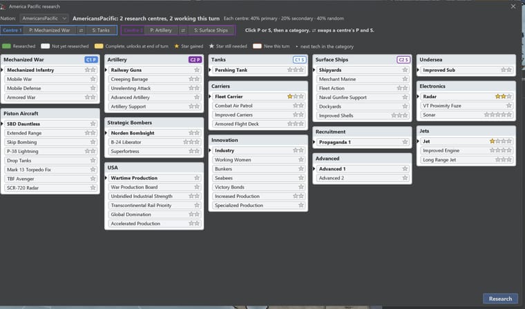
Unlike America Atlantic, America Pacific is able to research TBF Avenger (improved naval combat for torpedo bombers). Also combat air patrol (carriers get to participate in the interception phase). Also, B-24 Liberator and the Superfortress. Also the VT Proximity Fuze (ships hit by enemy air fire back on a +1).
America Atlantic's research screen
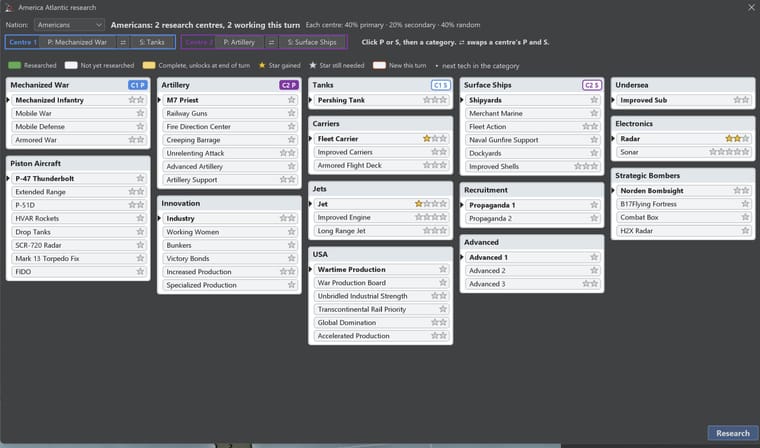
Techs that America Atlantic has that America Pacific lacks:
P-47 Thunderbolt. Adds +1 to hitpoints for dive bombers
HVAR Rockets: improves dive bombers against land
FIDO: improves torpedo bombers against subs
M7 Priest: allows you to build M7 Priests
Fire Direction Center: allows each Priest to support two units (offense only)
Flying Fortress and Combat Box

Hello! It looks like you're interested in this conversation, but you don't have an account yet.
Getting fed up of having to scroll through the same posts each visit? When you register for an account, you'll always come back to exactly where you were before, and choose to be notified of new replies (either via email, or push notification). You'll also be able to save bookmarks and upvote posts to show your appreciation to other community members.
With your input, this post could be even better 💗
Register Login