Global Dominance
-
@Frostion Perhaps in the long run.... but for now I am on a gin phase. That and I just want to get everything done.
-
The artistic additions will be made after the game is complete and changes have been made
-
@Hepps said in Global Dominance:
@Cernel Either way lets not change this behavior... it creates all kinds of possibilities and makes the engine more versatile. Besides the issue of giving a Carrier unlimited capacity is easily accommodated by playing around with the carrier capacity and the unit capacity cost (as already mentioned).
Instead of looking at it as bug we should simply add a clear explanation to the POS2 XML.
Just a notice, this is the Issue that, if done, would allow to support launching ships properly (and more), without turning the keel into a seaplane, sort of, if you want to go there and give a thumb up:
https://github.com/triplea-game/triplea/issues/461I've actually some concerns about this carrier cost 0 thing, but haven't tested so far. Also, of course, this won't by itself disallow hulls from flying from territory to territory (I guess you intend it to be user enforced or enforce it via canals or territory effects).
-
If a permanent fix is planned... then that is great news. However, until then I am perfectly fine with a "hacky" approach that may include some player enforced rules.
-
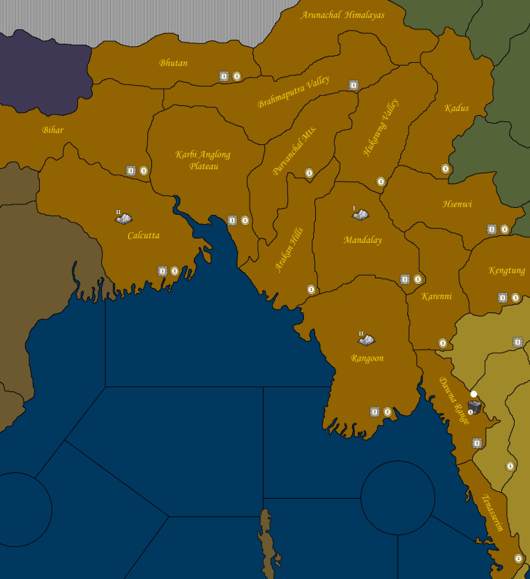
So here is a pretty focal part of the map.

If anyone is profoundly skilled at naming conventions.... or has a true calling for regional geographical research... then would the real slim shady please stand up... please stand up... please stand up.
I feel like this is a reasonably accurate representation... and yes most are geographical as opposed to political names... but I am struggling with area's in China and Russia particularly.
So if you have a rock hammer in one hand... a set of period Atlases in the other... and a laptop wedged between your legs...
Then drop me a line... cause I still have a couple of territories I could use a hand naming.
This position is a FULLY UNPAID internship... and should be considered valuable life training on how to waste the better years of your life
-
@Hepps
Send me a pic of China and I'll help you with it -
@Hepps I can do the namings for Manchukuo, if you want it to have the Manchukuo names (can be argued both ways, as Manchukuo, with its now forgotten extensive renamings, was not recognised by most, but considered just an occupied part of China) and @CrazyG doesn't include that in China. Up to you, if you prefer having the Manchukuo names for Manchukuo or the names of pre-Manchukuo (still the official ones for any nations not recognising Manchukuo, like UK and USA); in the second case, I'll bail out.
-
@Cernel I'd rather the closest names for an individual region based on the period.
I'm less interested in what we call them now... verses what they were called at the time by the powers that controlled them.
-
@Hepps Correct, but what I was saying is that, if you want, I can do the Manchukuo names if you want the names used by the Manchukuo state. That state was not recognised by about all not Axis countries but the USSR; so you may not want that, but the names that were official there before Manchukuo. For example, you prefer Changchun or Hsinking? If you prefer Hsinking, then I can do the rest of the Manchukuo names the same way. If you prefer Changchun, I'd leave that too for @CrazyG. It is totally up to your decision. In my Axis country atlas you see Hsinking, but I'm not sure if that would apply to countries not recognising Manchukuo.
Ah, and of course, would need your base image for it. -
Minor note, in WAW we used Changchun and the other Republic of China official names, as you can see, but that was decided that way just because Hsinking (capital of Hisaichi) would have been too similar to Hsining (capital of Chinese).
-
@Cernel I'd rather whatever they called themselves at the time.
Because by my interpitation that IS what they were called.
I like the history of it. I like that there were differences based on ownership. But I think its important to recognize those in depicting something of a historical nature.
-
@Hepps Right, so just upload it the drawing of Manchukuo anytime and I'll post the names for it.
-
@Hepps
I could give a hand with the USSR. Will you send black/white part of the map to the helper? Maybe we could number the territories and make a txt list with the names. If you want some help
PS: I agree that territories should be named what the locals would name them, but I also figure that some territories would be better named by their international known names.
-
@Frostion said in Global Dominance:
PS: I agree that territories should be named what the locals would name them, but I also figure that some territories would be better named by their international known names.
I guess Hepps meant (one of) the internationally known versions of the names in use by the (not necessarily recognised by the League of Nations, as Manchukuo never was) state actually controlling the territory at the time, tho I'm not sure that would be even doable in the case of the Tibet not under factual Chinese control, during WWII (from about the middle of Sikang westward).
So, what I understand is that Hepps meant "de facto", over "de jure", or "ex factis jus oritur", like "Fengtien" over "Liaoning", not that he wants "Moscow" called "Moskva" or "Cologne" "Koln" or "Rome" "Roma", etc..
On this matter, I can also make the namings for the Mongolian People's Republic, assuming using those of the Soviet puppet regime, and if it is ok to use those of 1945 (the only ones detailed enough I have). I would use those of 1939 for Manchukuo.
Also, I believe my names for Manchukuo are in postal romanization. If @CrazyG would use Wade–Giles for China (for example, "Hsining" is Wade-Giles, while the postal romanization would be "Sining"), or anyways not the postal romanization, this may be a problem, as it would look unpolished to use incongruous systems for Chinese (the Manchukuo names are not the Chinese ones, but are still in the Chinese language). I don't know if @CrazyG would be, then, able to convert my Manchukuo based names to whatever romanization system he is going to use, but I would suggest so (I'm not reliably able to do it) (of course, it should be a system in popular use during WWII for English named maps). -
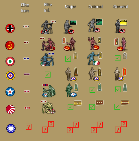
And so work has recommenced...

Almost through all the command units.
Taking a break can be so invigorating.
-
@Hepps Very nice. Du you have national Chinese ranks figured out? I found this site that seems to know what it's talking about. It's in Chinese, so I have no clue what it reads. I do know from another picture that a lieutenant's collar symbol is red background, with one golden stripe through it and two triangles on top. I guess a captain would have one golden stripe and three triangles. Maybe a major would have two golden stripes with a single triangle. But I have no clue of the two higher ranks.
 Hope there is a Chinese Triplea player around if you don't know better than me!
http://www.hoplite.cn/Templates/hpjh0053.htm -
@Frostion Yah I have all the resources.... just haven't gotten there yet. Thanks for the link. All resources are good resources.
-
@Hepps Looks pretty good. Couple of questions:
- Would it make sense to keep which side you show the rank symbol consistent across a nation's units (Soviet Colonel looks to be the only exception so far)?
- Would it be possible to outline the rank symbol in some color besides white to make it easier to identify major vs colonel vs general? So say maybe major->bronze, colonel->silver, general->gold, etc.
-
@redrum Just getting the layouts and element designs done... once I have everything worked into a usable/satisfactory image I will have everything aligned uniformly based on the direct the units for that nation face.
As far as outlines... I will re-examine after they are all completed.
-
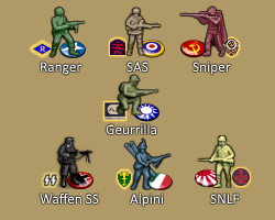
Little up-date... nations Special Ops units are all done now.
Here's a sneak peak at them.

Details of their abilities I leave a mystery for the time being.
