great accurate resource for map making!
-
While I think Omniatlas is great but still have some questionable informations.
-
Vichy France wasn't a German satellite state in fact it was recognized by a independent country by even various non-Axis countries like US or Soviet Union before they were at war with Germany.
-
Ireland and Iraq were independent states.
-
Egypt was independent with the exception that Britain had guarantee to protect Suez from foreign invasions. If Italy had stayed neutral, I doubt Egypt will fight Axis.
-
Italy didn't annex Albania.
-
-
@schulz Okej, let them know so they can update it......?
-
Try geacron.com. Every year from 3000BC on, covering the entire world with variable zoom.
-
@rogercooper supercool website. I'll have to delve into it sober sometime. Cheers

-
@ebbe pretty cool
-
@ebbe Claiming Vichy France not a German puppet state is against traditional narrative. Probably even has a potential to offend French people.
-
@schulz You're right, claiming historical inaccuracies is an injustice to those oppressed or worse. Look at the series "the underground railroad". Even the slight of the series' implication that there was actually an underground train on underground tracks transporting escaped slaves in the US has really upset viewers. Casting such fictional fog over sensitive history is never well received.
-
Claiming Vichy France a German satellite state is totally wrong, it is just Allies perspective without any basis. If it was a German satellite state why didn't they declare war on Allies or why didn't they hand over their navy to Germany?
Another problematic thing is Vichy France's official name was Actually "French State" but using it would be confusing since it is widely known as "Vichy France".
I can understand the reasons why some games or atlases simply prefer Allies perspective hence seeing Vichy nothing more than German puppet. But if a WWII game going to be politically accurate then they shouldn't go with Allies perspective.
-
@schulz Almost all of these relationships were fairly complicated. The distinction between ally, satellite and puppet exists on a continuum. Troops loyal to the Vichy French government fought the Allies in North Africa and the Levant. Many British colonies were technically independent nations such as Egypt and the princely states of India, but in practice the governments did what the British wanted or they would be replaced.
-
Another good resource is this not-free product http://historicalatlas.com/. Detailed maps of Europe & adjacent areas by month from the year 1000 to 2003. Particularly good at showing the many states within the Holy Roman Empire.
-
@schulz Hold your horses and lawyers....let me rephrase:
the country boundaries changing through time seems very very accurate.... and on the status given to some terr's: I agree that these allways are multi interpretable and also depending on the winners flavour in any conflict..... but still think this can be good resource for decent mapmaking and it seems:
even more for heated discussions, haha
anyway:
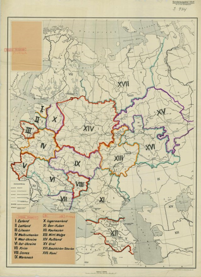
are there any russian mapmakers in the tripA house by the way?
I need some pretty accurate deepgoing info:or anyone else that can tell me :
i need a good map or description that shows
All main USSR River-crossing/bridges ... around 1940/ 1941yes gues what
I came a long way but need some reference &doublecheck -
@ebbe said in great accurate resource for map making!:
i need a good map or description that shows
All main USSR River-crossing/bridges ... around 1940/ 1941I think it is clear that this request could only come from a spy.
https://catalog.archives.gov/id/40480105
-



Hello! It looks like you're interested in this conversation, but you don't have an account yet.
Getting fed up of having to scroll through the same posts each visit? When you register for an account, you'll always come back to exactly where you were before, and choose to be notified of new replies (either via email, or push notification). You'll also be able to save bookmarks and upvote posts to show your appreciation to other community members.
With your input, this post could be even better 💗
Register Login