What software do you use to make reliefTiles ?
-
So I am talentless when it comes to graphics, but I want to have some map assets for my next redux map.
- I ran the Tile Image Reconstructor
- Loaded the new image into paint.net
- Thickened a line using paint.net saved it
- Found lots royalty free mountains on the net
- Found Inkscape, a free vector software package
- Loaded the new big reliefTile file and mountains into Inkscape
- Ran the Tile image breaker
Ran TripleA, omg it all came together.
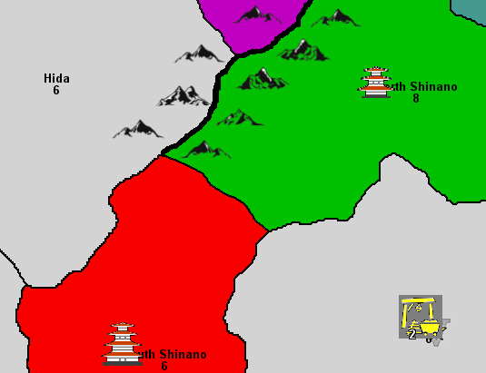
So the above is to show a mountain range that cannot be crossed, see below.
.
So what software do you use to make reliefTiles ?https://forums.triplea-game.org/tags/thedog
https://forums.triplea-game.org/topic/3741/curated-best-top-maps-triplea-guides -
@thedog wow the moutains look really nice !
No help on graphics from me. I have even less talent lol
-
I used GIMP for my map and relief tiles. It was some time ago now so the process is getting a bit fuzzy.
My reliefTiles are simply a textured overlay for the map, no special doodads or anything like your mountains.
One thing I discovered is that if you do a texture overlay it’s helpful to delete the portion of it that would cover your map border lines on the baseTiles, otherwise the texture being over top of the lines will make them less crisp and visible.
-
Gimp since its free, good quality software.
Also since it has layers you can easily edit stuff if you decide later that you want to move or delete something.
One thing to note tho is that in regards to your screenshot, if you were going to use a map of japan as a texture rather then add in some things like mountains then you would have to change the opacity to make sure that the territories have player colour.
-
@Contango @Zaroph
I did not like Gimp with its floating frames/windows. But, Gimp is raster based, how does it handle lots of png, ie Mountains and lots of other icons, are they all on one layer, like with Inkscape? Can use move each png without affecting any other layer or pngs?@Zaroph
Those colours are the players colours, I dont know how to use textures... yet.
Is this a texture, the fading white bits>
and this one, the sea shore?
Are these radial textures?
-
TripleA needs a png-file to break it into the tiles using the tile breaker.
A png-file always is a single layer raster-graphics file. You define the size of the file yourself and place that info in the map.properties file, such asmap.width=7700 map.height=3200Now, this is the info you entered, because your base-tile-image and your relief-tile-image do exactly have this pixel-size (before being broken).
For creating a png-file to use for TripleA any raster-graphics software that supports layers and transparency is fine.
So paint. net , Gimp, Photoshop, Affinity Photo .... or similar products are perfect.
Now, in the software of your choice you usually work with layers. You apply different objects to different layers.
Saving to png means to condense every layer into one resulting image consisting of only one "layer".
So it is important, that before you condense you save your work in the application's native format (pdn, xcf, afphoto, psd). With this file you can later remove layers, alter content, do whatever you want layerwise.
Not sure what you need a vector-graphics software for. When working from scratch you can of course design everything with vectors. The advantage would be that you can scale everything without quality loss. You can work with layers and save your work with layers, too.
But here, too, you need to condense it into a (single layer) png-file to use it. So save your work preserving all the layers before. Also be aware that converting from vector-format to raster-format might cause quality issues.But personally I would always start with a large raster image and work with layers. Size can be downgraded without visible qualitiy loss, later, if needed.
Not sure if that helps or even covers your questions. But that came to my mind when I read your postings.
-
@panther
Thanks for the reply I know very little about raster programs and their terminology.So it is important, that before you condense you save your work in the application's native format
Yes I learnt the hard way.Also be aware that converting from vector-format to raster-format might cause quality issues.
Yes my go to software is LibreOffice Draw and it can read and display in pixel format but fails to save in the correct pixel dimensions. Inkscape does it all correctly..
I like the way vector programs work and so I use them in preference to raster. For starters I have 5 mountain png right sized for drag and drop, these can be flipped to make 5 more, mirror images and can be easily resized, think of them as a stamp. I will be using both raster and vector software.My terminology here
The baseTiles are for the TripleA engine and would have the following layers, numbers = layers;- start with a free hand or traced outline of the coast line
- split the land and sea into territories
- Sea colour, flood filled with a colour or texture or nothing. I prefer nothing leave it till #5 below.
The reliefTiles are for humans to look at and would have the following layers
4. Copy of the complete baseTiles
5. textures and colours for sea and land territories- In my case switch to vector software to add another "layer" its not a raster layer, but lots of pngs sitting on top of the compressed reliefTiles, save as another png and break into 256px for TripleA.
.
When I know more about raster I might add a 7th layer/texture over the top of the pngs of layer 6.Broadly are the 6 layers correct?
Would anyone add more? -
@thedog said in What software do you use to make reliefTiles ?:
@Contango @Zaroph
I did not like Gimp with its floating frames/windows. But, Gimp is raster based, how does it handle lots of png, ie Mountains and lots of other icons, are they all on one layer, like with Inkscape? Can use move each png without affecting any other layer or pngs?Gimp also has the ability to do vectors, they call these “paths”. I remember using them to create my territory outlines and also a silhouette of a standing army for neutral territories.
In GIMP, if you want several small icons, I think you need to paste in each as a new layer if you want to move them independently. However if you’re content with the locations of all of them you can then merge all of the layers in to one. Once it’s merged it would be hard to move an individual icon, but you could delete them individually, create a new layer to move it to where you want it, and then re-merge your newly created layer with your general layer for that icon. There might be better ways, but I’m not expert and that’s how I figured it out.
For example, I did something similar with Air/Naval bases and convoy markers. Once they were all in place as several individual layers, I merged the layers so I would only have one layer for convoy markers, and one layer for air bases.
-
@contango said in What software do you use to make reliefTiles ?:
In GIMP, if you want several small icons, I think you need to paste in each as a new layer if you want to move them independently.
paint.net does the same, one small icon per layer. paint.net also had a similar problem moving icons around.
For your next make map checkout Inkscape.
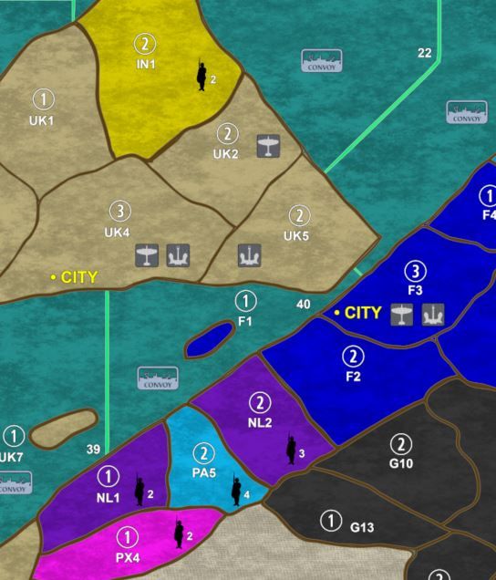
I like your icons, what is the map called?
-
It's G40_Alt_Universe, in the Experimental section in TripleA.
I should also clarify that the image I posted was of the print version of the map, not the TripleA version.
More about it here if you're interested:
https://www.axisandallies.org/forums/topic/36740/1940-global-alternate-universe-g40-alt-universe -
@contango
Wow, your printed map is a labour of love for the A&A style of game.Did you learn how to use Gimp just to test it in TripleA and then to produce the physical map?
-
Actually the physical map was the primary goal, I learned GIMP to make that first and then afterwards started working on the TripleA version.
The TripleA map was relatively quick/simple because I'd already had the physical version of the map with all of the territory borders created using vectors. So effectively I just scaled it down and hit the trace button on the borders vectors and was done.
Hello! It looks like you're interested in this conversation, but you don't have an account yet.
Getting fed up of having to scroll through the same posts each visit? When you register for an account, you'll always come back to exactly where you were before, and choose to be notified of new replies (either via email, or push notification). You'll also be able to save bookmarks and upvote posts to show your appreciation to other community members.
With your input, this post could be even better 💗
Register Login