Power of Politics 1914 : A WWI scenario
-
-
@redrum LOL!
-
@Hepps Just looking at the map at the first post, I feel like putting forward the following corrections (I'm not an expert of WW1, so I may be easily overlooking something):
- That territory north-east of Austria-Hungary looks very much like Galicia (officially the "Kingdom of Galicia and Lodomeria"), and especially where its capital Lemberg/Leopolis (now Lviv) is. If so, that should be Austro-Hungarian, not Russian (I know I already said this). In particular:
https://en.wikipedia.org/wiki/Battle_of_Galicia - The Sinai should be English, not Ottoman. However, that territory was mostly out of control, and I guess it can be considered factually pro-Ottoman.
- Kufra and most of that south eastern territory of Tripolitania-Cyrenaica (meaning future Libya) should be English, not Italian (but I'm really not sure here). However, that territory, as well as most of italian Tripolitania-Cyrenaica, was actually out of control, since before WW1 (Senussi).
- I get it is for placement, but maybe French Somaliland can be made a tad smaller (I guess nothing really going on there).
- The sandy/marshy deserts representation of the Sahara is not bad, and better than most available TripleA games (not hard), but I can see it is missing the Grand Sand Sea and nearby Quattara depression (together cutting the easily transitable land to a relatively small cockepoint nearby El-Alamein) as well as the Grand Eastern Erg and nearby Chott el Djerid depression (together cutting the easily transitable land to a relatively small cockepoint north of Gabes: the Wadi Akarit). I realize that with the Entente controlling all North Africa, this should be a much smaller deal than in a World War 2 game. Here it is a very good map, at least for the dunes:
https://en.wikipedia.org/wiki/Great_Sand_Sea#/media/File:Saharan_topographic_elements_map.png
More detailed for central north Africa:
https://en.wikipedia.org/wiki/Capture_of_Kufra#/media/File:Carte_Koufra.jpg
- That territory north-east of Austria-Hungary looks very much like Galicia (officially the "Kingdom of Galicia and Lodomeria"), and especially where its capital Lemberg/Leopolis (now Lviv) is. If so, that should be Austro-Hungarian, not Russian (I know I already said this). In particular:
-
@Cernel said in Power of Politics 1914 : A WWI scenario:
@Hepps Just looking at the map at the first post, I feel like putting forward the following corrections (I'm not an expert of WW1, so I may be easily overlooking something):
- That territory north-east of Austria-Hungary looks very much like Galicia (officially the "Kingdom of Galicia and Lodomeria"), and especially where its capital Lemberg/Leopolis (now Lviv) is. If so, that should be Austro-Hungarian, not Russian (I know I already said this). In particular:
https://en.wikipedia.org/wiki/Battle_of_Galicia<
You had already mentioned this earlier and we established that the initial drawing was done for marketing purposes only. The territory of Galicia starts as Austrian.
- The Sinai should be English, not Ottoman. However, that territory was mostly out of control, and I guess it can be considered factually pro-Ottoman.<
This as well has already been addressed earlier in this thread. Since the British defenses were set up roughly right at the edge of the Suez canal... and since the Territory of Cairo Controls the canal... I chose to make the initial set up with the Ottamans already controlling the territory for game-play purposes.
- Kufra and most of that south eastern territory of Tripolitania-Cyrenaica (meaning future Libya) should be English, not Italian (but I'm really not sure here). However, that territory, as well as most of italian Tripolitania-Cyrenaica, was actually out of control, since before WW1 (Senussi).<
While the Territory of the Western Desert was on paper in the hands of the British, in all actuality it was not controlled by them. If anything it should really be part of the Darfur tribes. Which probably makes more sense for the game.
- I get it is for placement, but maybe French Somaliland can be made a tad smaller (I guess nothing really going on there).<
Many territory sizes have been done to make room for placements. I tried to make the map with the greatest possible space for placements as opposed to total geographic accuracy. I highly dislike maps with territories with 1 placement it is problematic from a game-play stand-point.
- The sandy/marshy deserts representation of the Sahara is not bad, and better than most available TripleA games (not hard), but I can see it is missing the Grand Sand Sea and nearby Quattara depression (together cutting the easily transitable land to a relatively small cockepoint nearby El-Alamein) as well as the Grand Eastern Erg and nearby Chott el Djerid depression (together cutting the easily transitable land to a relatively small cockepoint north of Gabes: the Wadi Akarit). I realize that with the Entente controlling all North Africa, this should be a much smaller deal than in a World War 2 game. Here it is a very good map, at least for the dunes:
https://en.wikipedia.org/wiki/Great_Sand_Sea#/media/File:Saharan_topographic_elements_map.png
More detailed for central north Africa:
https://en.wikipedia.org/wiki/Capture_of_Kufra#/media/File:Carte_Koufra.jpg<
I did not add a lot of details to this map that I might otherwise have. Since there is likely to be much less action in North Africa than in a WWII scenario, I felt these additions were not really worth while.
- That territory north-east of Austria-Hungary looks very much like Galicia (officially the "Kingdom of Galicia and Lodomeria"), and especially where its capital Lemberg/Leopolis (now Lviv) is. If so, that should be Austro-Hungarian, not Russian (I know I already said this). In particular:
-
One quick holiday teaser for all the Canadians out there...
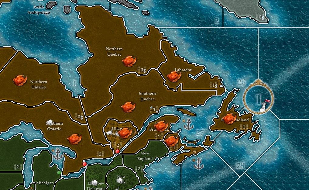
The turkey unit unfortunately provides all units with a -1 Att. and Def. penalty. But rest assured... all your troops die in a blissful Tryptophan educed coma.
Happy Thanksgiving to all the Canuck warmongers!
-
Wow this map looks very cool. Can´t wait till we can play it!
-
@Hepps It went awfully quiet in here...

-
@redrum Touche!
-
about 7 new posts over a day or so is kinda low but the visitors today is like 20 ish so thats kinda up -.-
-
@Captain-Crunch I think he was calling me out personally on my comment in @Name thread about his map development.
 More or less a jab at my kidney trying to get me motivated.
 -
@Hepps Ponders emailing more Scotch? Never mind that slowed the donation drive banner me thinks … Hi H

-
@prastle What it lacked in motivation it more than made up for in personal job satisfaction.

-
I'm afraid if I don't leave this somewhere it will be lost to time forever.
Here is the Pop_1914 folder which I have. It includes a tweak I must have made at some point, to the under image. Probably while trying to get blends to work under the newer scheme, or who knows, it was like years ago now.
This map/game is not in a fully completed state, meaning I'm not sure if meets the specs for the pre-release 2.7 is stuff. It won't autounzip, but if I extract the folder and place that downloaded maps it will launch up. I think perhaps just needs a yaml in the right spot, or to match the new structure for that stuff in the latest tripleA way.
It's missing some elements, unit graphics I believe, as I only had Germany for that from Hepps, and I think the others may need to be worked up. but this is everything I have for it so I didn't want it to be lost. Going like 5 years on my old dropbox links probably will be defunct eventually. Anyhow here it is from the archive on my drive.
Power of Politics 1914 (Map/Game Folder)
https://drive.google.com/file/d/16IwfPRBcPzAXTu-F7HN4mYBAobiRq_vU/view?usp=sharing
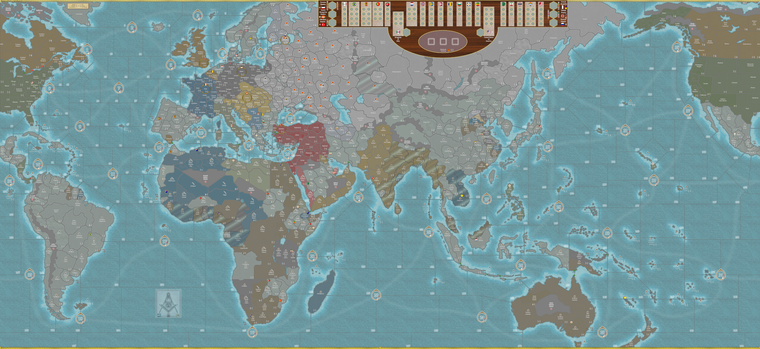
That includes everything I was given by Hepps and Redrum at whatever point that was back in like 2020. The way Hepps did his design, the Misc folder was used to include all the decorative elements in tiles (basically like same way as using the map tools tile_breaker in map tools/tile_reconstructor in other optional tools. I believe what I did was to isolate out the convoy lanes, and then put it back in a reduced opacity, and changed the base ocean color to a lighter color for blends. This was just me trying to customize what was already there, hence the backups in case anyone needed to restore. Here is an image with blends on and then another blends off, so you can see what all is there.
Image (export gameboard image)
https://drive.google.com/file/d/1TuXZ1ry7nqqyAGiZPphSzo8kmsJ5Yt0S/view?usp=sharing
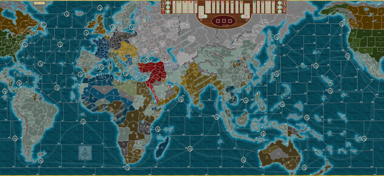
Image (export gameboard image blends on)
https://drive.google.com/file/d/1-sEamonkaYpPcztZAwDnhKEaaeC8f--b/view?usp=sharing
Unit purchase (screen)
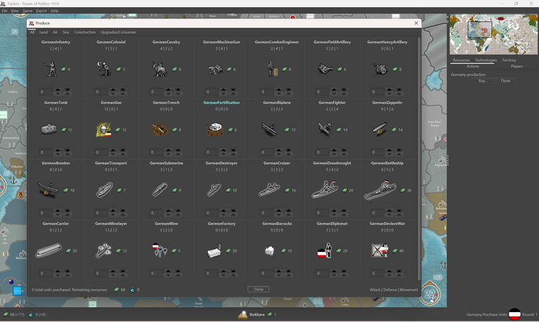
There screen for G1. Right now G is the only faction with graphics, so I think that would need to be the basis, at least for Central Powers. Perhaps the Entante could just be made in the similar style. Graphics for that one all 48px, but might do an upscale if I can find the time. Otherwise I think Hepps stuff all looks pretty badass though, I mean stylistically it's all very visually cohesive with his other tripleA boards, and has the unifying vibes. Not sure what if anything comes of it, I just didn't want to lose all that work that they put in. Map is in a WIP state still. I'm not sure of the ultimate design vision for the politics and such, but wanted to make sure it was saved somewhere at least.
Best
Elk
