Ancient Empires: 222 BC
-
@Name So, how can you see the "aaGun.png" unit images, assuming you do.
EDIT: Nevermind. As I said, in WAW I could not see images with a full stop in the notes, but I was able to see them as unit images in the game. Seems like these strange issues happen only when you want to show images in game notes, or such. No idea why.
-
@Cernel never had an issue with such. I tried something else, could be the case:
<img src="socialwar.png"/> in notifications
but socialWar in docs/images.It worked this way.
-
@Name Well, I believe in windows "socialWar" and "socialwar" are the same, in file names, so that works. However, it will not work in case sensitive systems and it may not work if you zip the map.
However, in Windows I believe that should work if you have socialwar and socialWar, associated in all 4 possible combinations. I never had this issue you are having.
-
@Name Looks tantalizing. Can't wait to see more as you continue to progress.
-
@Hepps Thanks:)
Here's some progress:
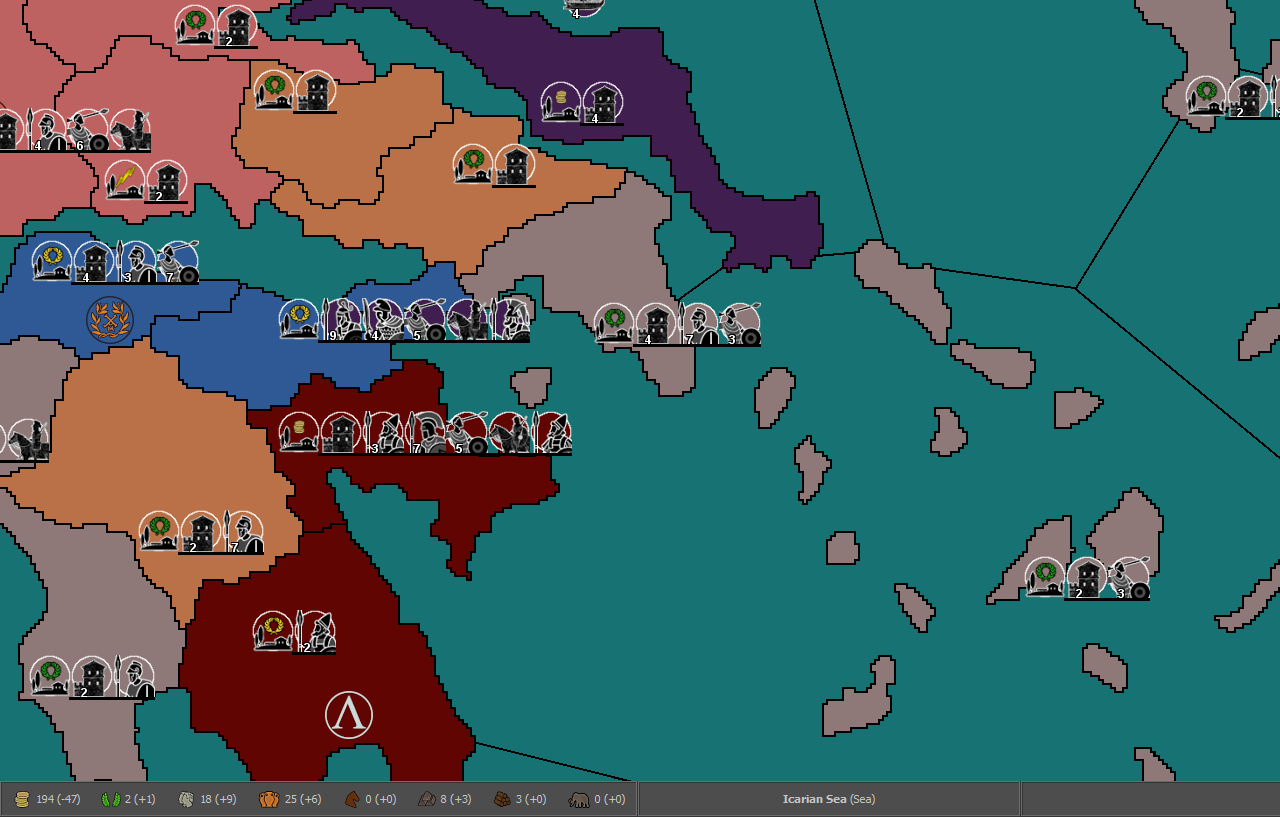
The Romans are in game (army roster still WIP), only with a portion of their land though.
I'm puzzled by the supply system. There are situations where some players will be unplayable if I reduce supplies given by territories. But over time most players stockpile more than they could ever use, since they don't move all troops all the time and are rarely near their cap. Maybe I should do away with fuel and use supplies just as a cap on total troops?
Also, do I need to set up TUV for non-PU units for the AI to function properly?
-
@Name Fuel is generally very hard to balance. The only games I'm aware have done so to any reasonable level are Civil War and Iron War. You generally need to decide what you want fuel to add to the game. I would recommend looking at Civil War if you haven't as it uses both fuel and maintenance/pop cap mechanics.
Yes, you should give all units a tuv value for both the AI and for the battle calc to be more meaningful.
-
@Name I suppose the swordsmen are representing the antepilani and the foot_guard the pilani? But no division between hastati and pricipes? With this level of detail, I was totally expecting to see hastati, principes and triarii as separate units, but I totally agree keeping the name generic, if they are just representing something generally available to others, under other names (for example, skirmishers over velites).
-
@redrum thanks, I'll check those.
@cernel I might add several more units, unique to their faction, even if just for names/representation. But for now I'm keeping it simple to get it more functional first. Besides that I'm struggling to find meaningful and logical differentiations between melee infantry types.
Those are:
1 - Spearmen 2/3 (thureophoroi and other spear/shield levies of various types).
2 - Phalanx 3/4 (both pikemen and some heavy hoplite troops, although the later should be almost gone by the timeframe).
3 - Swordsmen 3/4 (hastatii, principes, thracian rhomphaiophoroi, celtic heavy foot etc).
4 - Foot guard 4/5 (royal guard infantries and other elites/veterans, such as triarii).2 and 3 are my main issue. Phalanx should be stronger unless it lacks flank support or is on broken ground. But giving hill/mountain bonuses to Swords would mix them with Skirmishers. Giving the later even bigger bonuses will make them too strong for their cost, or too cost-inefficient on flat land if I also increase the cost.
Maybe I could have Phalanx at 2/3 with 1/1 (or 2/2?) bonus on flat, or 3/4 with -1 attack on hills/mountains or something along those lines. Or could have Cavalry and/or Skirmishers give support to phalanx, but I don't want to mess with support for many units, keeping it for Elephants (-1/-1 on 3 enemies?) and possible leader units.
Also not all units of the same class should be equal in strength but that's a lesser issue.
Unrelated, on the possibilities of altering territory resources/effects with triggers:
Can I alter only territories from a list?
Is there a way to select at random from all territories, say for a weather/disaster effect?
Is there a way to select at random, but only from territories with manpower (resource) > 5? -
@Name Well, but the triarii were hoplites, and arguably of a particularly flexible kind, so substantially something in between of the "swordsmen" and the "phalangites", or even something in between of the "swordsmen" and the "hoplites". So, I think the game should rather represent them that way. On this regard, I'm not sure how much the Macedonian phalanx took over the hoplite phalanx, in the various civilizations at the time. I also understand you decided not to differentiate between hastati and principes (basically, you just have antepilani and pilani), then, though I maintain, in a game of this complexity, that would feel unrefined (my opinion).
The easiest way of representing the phalangite as stronger than the swordsman, but more fragile on its own, is, of course, making the phalangite costlier and stronger than the swordsman, while having the skirmisher unit being the cheap fodder, so that, if properly balanced, the phalangite will be more complementary with the fodder than the swordsmen. The main challenge, of course, is taking care either the swordsmen or the phalangites not making the other unit obsolete (like, for example, in WAW the marine makes the elite a useless unit, not on their own, but in the moment you combine then with infantry).
-
@Name said in Ancient Empires: 222 BC:
@redrum thanks, I'll check those.
@cernel I might add several more units, unique to their faction, even if just for names/representation.
I'd actually avoid having same units called with different names just for flavour. I think it's better having a single name for any single different unit type. I'm very much not a fan at all of things like, for example, the "Panzer" of New World Order, that is just an "Armour" renamed for the hell of it. Again, just my point of view, and there might be cases in which I might want making an exception.
-
@Name said in Ancient Empires: 222 BC:
Maybe I could have Phalanx at 2/3 with 1/1 (or 2/2?) bonus on flat, or 3/4 with -1 attack on hills/mountains or something along those lines. Or could have Cavalry and/or Skirmishers give support to phalanx, but I don't want to mess with support for many units, keeping it for Elephants (-1/-1 on 3 enemies?) and possible leader units.
I'm actually not even sure mountains should be a bad terrain for phalangites. After all, mountains means passes, and passes means choke points, and choke points are the best for phalanx formations. Also, if you consider the terrains where armies developed historically, the phalangites (first hoplites, then Macedonians) were the main units of the Greeks, and the Greek homeland is usually a rugged and mountainous terrain. Then, in medieval times, we have phalanx formations for the Scots and the Swiss, the Swiss substantially reinventing the Macedonian phalanx, again in particularly mountainous and forested terrains.
-
@Name said in Ancient Empires: 222 BC:
Unrelated, on the possibilities of altering territory resources/effects with triggers:
Can I alter only territories from a list?
Is there a way to select at random from all territories, say for a weather/disaster effect?
Is there a way to select at random, but only from territories with manpower (resource) > 5?No. TripleA currently doesn't support random selection; say, for example, making a list in a trigger, and picking one of them. Of course, with a lot of triggering, using chances, it is possible to recreate such a behaviour. For example, instead of picking 1 territory amongst 100, you can have 99 chained triggers that activate another trigger, recreating a situation in which you have a 1/100 chance to end in any of them, but this is very complex. A good example of random effects can be the plague of War of the Relics. An easier example of pseudo-picking is the six sided dice rolling generator of Blue vs. Gray. A relatively easier workaround would be making an integrated minimap of some sort, using on them the "Risk" stile random place delegate, then looking at those zones and triggering the wanted results on the actual map, then cleaning such a minimap box with more triggers. The most basic example of random place delegate may be Conquest of the World, that you can manually download from the repository (it is not in download list). However, I warn you that if you would, for example, take 500 territories and say that each round each of these territories have a chance of a weather effect (in this case, nothing to do with any lists, just each territory having its own chance assigned), that will result in an extremely slow game when you play live (it can be very fast on local, like playing AI or hotseat, instead), as you would have to wait for all those triggers, testing chances, to send the dice results to each player in the game, each time they fire, before proceeding to the next. I feel this may be something that can be improved, and War of the Relics would be a good test map, already, but we need a developer doing that.
-
@Cernel said in Ancient Empires: 222 BC:
I'd actually avoid having same units called with different names just for flavour (...).
Fair point, I'm leaning towards it anyway, because else it's extra work and the possibility of overwhelming new players with extra info, just for flavor.
@Name Well, but the triarii were hoplites, (...).
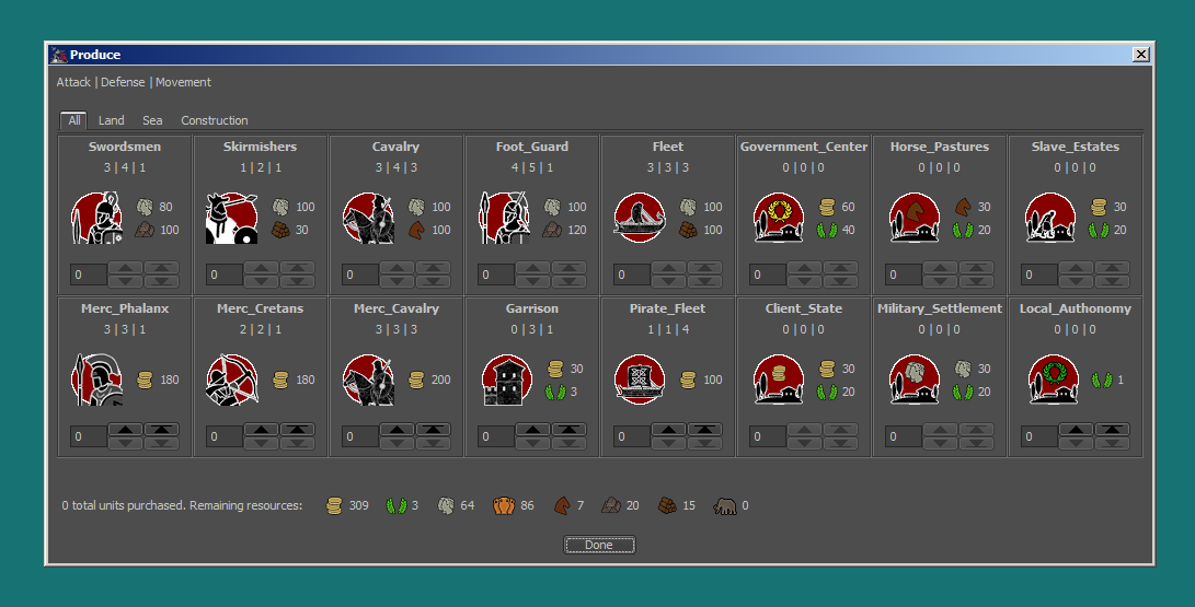
Ok let's first describe my plan so you can give better feedback. I'm thinking of having 7 or 8 land units per player (maybe one more if everyone gets - resources allowing - access to Elephants).
For (purchase) display consistency (see a few posts before) it should go:
- Main Foot
- Merc_Foot
- Skirmisher
- Merc_Skirmisher
- Cavalry
- Merc_Cavalry
- Special/Elite Unit
- Special 2 (and/or Elephant)
The Romans in this setup would have:
- Swordsmen (Hastatii/Principes)
- Merc Phalanx or Spearmen (representing the Soccii or other "Allies"?)
- Skirmishers (Velites)
- Merc_Skirmishers (Probably Cretans)
- Cavalry (Equites)
- Merc_Cavalry (Soccii or other "Allies"?)
- Foot Guard (Triarii)
- Extra unit/Elephants?
Maybe I could cut out the Merc_Foot from Rome to add Principes there, assuming an allied legion has similar unit types to a roman one . Or add Principes as a Special Unit along with Triarii, but that would kinda break my format.
But naming/role issues arise. Maybe I could rename infantry types:
- Medium Foot/Infantry: Spearmen + Hastatii (2/3?)
- Heavy: Phalanx + Principes (3/4?)
- Elite: Foot Guard + Triarii (4/5?)
By 222 BC (though we don't have detailed information), most greek states would field thureophoroi (and of few of them pikemen or hoplites). Boeotia and Megalopolis already had pikemen, Sparta changed it's hoplites to phalangites around 225, Achaia it's thureophoroi to phalangites a few decades later and I think that's what we know. Outside of "greece proper", successors would mostly field pikemen (Pergamon possibly not) and non greco-macedonian states would employ their own fighting styles (Carthage for example would be dependent on it's available mercenary types and shifting away from hoplites to some degree).
Thing is, phalangite equipment was usually cheaper than a hoplite's (due to a far cheaper shield) or swordsman's (no/lesser sword, cheaper shield) assuming equal armor, though it can be argued that successors started using heavier pikemen with more armor and longer sarissas (and paid for the reduced mobility against the Romans). Pikemen also required more training to be effective, so your pricing/balance suggestion makes some sense.
But overall then, what stats should I use, if I include hastatii + principes + phalanx + triarii? Do away with the foot guard type - which I'd rather not - and go like hastatii (2/3), principes (3/4), phalanx/triarii (4/5)? I'd like to keep 6 only for Elephants in defence.
I'm actually not even sure mountains should be a bad terrain for phalangites (...).
Deppents on where the battle took place and I agree about choke points. Pikemen, especially early, (lighter ones) and hoplites would operate well on smooth hills/slopes. But having to advace in rough terrain would be detrimental, especially for heavy pikemen. Then again, at least elite pikemen (in some cases all of them), could also operate as skirmishers with half of the sarissa, shield and javelins. But Cynoscephale and Pydna were fought on rough greek terrain and it was one of the reasons Macedon lost both battles. It's hard to simulate maneuvering in game. Maybe phalanx could have -1 attack on rough terrain but no defense penalties? So far I've used Mountains (and to a lesser degree hills) as a way that cheap skirmisher armies (say of a highland tribe or small state) can hold their ground against superior units.
No. TripleA currently doesn't support random selection (...).
Thanks, seems I won't consider such things, at least for now.
-
@redrum I checked Civil War
Unrelated, I found a possible bug: I can't move troops in and out of Upperville (under "Manassas" rail line), Eastern Campaigns Scenario.
On topic. In my (limited) tests, it seems that resource overstacking is even worse in CW. Depending on what you purchase or not (and how much you move), some or even most resources can potentially skyrocket fast, providing practicly inexhaustible stockpiles. Supplies/Fuel is very similarly implemented to mine, troop cap (manpower) better I think.
It also gave me some ideas. Feedback very welcome.
Maybe I should remove supplies, and use PUs in it's place (upkeep & fuel), in addition to it's previous applications. Since it's needed for other things, it won't just grow in most cases, just so a few odd ones are covered. Real supply harassment is not possible anyway (unless I replace the system with a supply train unit, needed to move troops, but I bet that would mess the AI). So I guess my Supplies resource is just flavor hintering gameplay. I'm fine with wealth representing supply potential and making agricultural regions richer to balance the map.
Then I could also steal CW's manpower system (each unit has 1 manpower upkeep), just a limit on how many (non-mercenary) units are possible, and have units also cost PUs instead of manpower. Example:
Phalanx
100 PUs 80 Iron
Produces Resources each Turn: -1xPUs -1xManpower -1xIron
Fuel Cost per Movement: 1xPUsMerc_Phalanx
360 PUs
Produces Resources each Turn: -3xPUs
Fuel Cost per Movement: 1xPUsThis also adresses the issue mentioned by @Cernel (killing off your mercenaries first cause they had huge PU upkeep, now they are just much more expensive to recruit - numbers are just examples, will need tests)
Finally, in a possible extreme makeover, I'm thinking to add Population Classes. Probably just 2 of them, Nobles and Freemen, needed for different types of units instead of generic manpower. Slaves would just be represented by the Slave_Estates Government/Structure. No Citizens, so it's generic enough to fit tribal states, unless:
UI concerns.
The way the game is setup now, I can have up to 4 resource types per territory (with a total of 8), else there are display issues in the lower bar. This could be offset by moving some resources to pre-placed structures, which is not ideal (visual burden, more work) but has other upsides (flavor, "pillaging"/destruction of productivity, possible upgrades, though the AI would need triggers to get them). Without such changes, I can only potentially add 2 resources. That's if I remove supplies and replace territory manpower with Freemen, I could add Noble (and extra Freemen) generation to some government types.There's the resources tab issue as well though. Already with 8 resources it needs to be dragged to show gains/losses once a few numbers go over 99. Adding more resources would make this worse, perhaps even hidding current numbers. So maybe I should sacrifice manpower diversity and supplies to somewhat improve the resources tab display, cutting it down to 7 resources?
-
@Name Yeah, I think there are a number of bugs in the Eastern Campaigns Scenario still as it was really just meant as a tutorial to the mechanics and isn't really balanced. Have you played around with a House Divided as well? I think that is much more balanced. You do get some fluctuations in supplies/fuel but generally it is something that a player constantly thinks about in terms of: should I spend the resources to move these units vs saving the supplies for other uses as well as the mechanic of winter that makes fuel costs higher during certain turns. There also is more economy than most games around different infrastructure that you can build in order to get more resource generation. If you are interested I can write up a high level strategy guide around it but here are at least some example games of decent level players:
https://forums.triplea-game.org/topic/592/civil-war-3-2-4-redrum-confederate-vs-wirkey-union
https://forums.triplea-game.org/topic/879/civil-war-3-2-4-redrum-confederate-vs-wirkey-union-2
https://forums.triplea-game.org/topic/897/civil-war-3-2-4-wirkey-confederate-vs-redrum-unionYeah, I'd generally ask is what does PUs and supplies each represent and does having both add strategic depth/realism to the game? If you can instead tie them both to just 1 resource its generally simpler and probably easier to balance though having multiple resources can add more options around converting resources from 1 type to another or certain territories being rich in one vs the other or even different buildings that generate each of them.
CW's manpower system generally works well and also helps to prevent the game from "running away" once a player has a small lead. The reason is if you are losing some then you probably have extra manpower and can churn out cheap units vs if you are winning some then you are more constrained since you already have lots of fielded units and have to carefully use your remaining manpower. Its good to make units cost a small amount of manpower as well so that you avoid people overspending their manpower.
Looking at your example values, the upkeep seems very low compared to the purchase costs. Just something to keep in mind as that would generally mean you can only purchase a few units per turn but the max number of units would be pretty high.
I would generally advise having a combination of territory resources and building generated resources as it creates a more dynamic system and can better simulate pillaging, etc. I'm open to making adjustments to the UI to help better display resources. Generally, the size of the resource icons you are using influence a lot of things as well. I would focus more on your ideal system and then we can discuss if UI flexibility or customization can be improved to better support it. We just don't have many maps with more than a handful of resources so that's what the UI is built around.
EDIT: One thing I forgot to mention is I think making the fuel resource(s) so they are used for more than just movement is a better approach. The main reason is it makes it easier to balance and a more positive experience for the user. Having it so extra "supplies" in this case are then used to purchase units/buildings so that you kind of have a "should I spend more supplies on movement vs save to buy units" is a better mechanism than just "do I have enough supplies to move all my units that I want to move". It also makes it so there is a way to use extra supplies vs just stockpiling which generally leads to more stockpiling and a system that becomes meaningless.
-
@redrum I assumed Eastern Campaigns is just the same game reduced to one front. I'll check HD and the links, no need to write a guide. What I should do more in general is test other maps, especially ones with similar mechanics to what I am for. Any other suggestions?
I found one more possible reason to keep supplies in (and use it for other costs as well per suggestion). The AI might not keep enough PUs to move (or the opposite if I set move before purchase). Could it handle it? Else it might be a good idea to remove fuel. My strategic resources limit strong units anyway (like fuel secondarily does, as a shoft cap though, in IW and CW).
Highly reducing the mercenary upkeep will also allow to tone down unit costs compared to upkeep, free a little UI space and bring the map closer to what people are used to. Not sure on the price/income range though yet.
I'm already using a combination of building generated (through "government" factories - many of which are destructible) and territory generated resources. But I wonder where to draw the line. I don't want to handicap the AI too much.
Good to now know on the UI. Btw i'm using about 20-24 pixel resource icons, I think smaller would be too small.
-
@Name Well the maps that probably are good quality and have some interesting mechanics that I'd recommend looking at besides Civil War are:
Total World War - probably the best overall quality map in TripleA that uses a number of advanced mechanics like research/technologies, trains, minor nations, terrain types, lend & lease, many different unit types with AA and support attachments
Greyhawk Wars - pretty unique map with lots of events, heroes, etc
Dragon War - pretty unique map with some randomized placements, several resource types, different barbarian nations
Domination 1914 NML - interesting trench/gas mechanics along with simple tech system
Power of Politics (in development): https://forums.triplea-game.org/topic/1063/power-of-politics-1914-a-wwi-scenarioFor complex maps (and for the AI), its generally better to probably put the purchase phase after all movement. This works well for TWW for example. The AI generally doesn't handle fuel very well and will probably do better if the map doesn't have it.
So the AI doesn't understand how to build resource generating buildings like in Civil War. So for AI compatibility, you'd want to lean towards keep it simple and having the resources being primarily generated by the territories.
There are different size resource icons for different areas so depends which one you are talking about but generally the sizes used in Total World War and Civil War are pretty good IMO.
-
To add to that... thinking of 1 player games... I seem to remember a Pacific War Campaign that @Zim-Xero might have created that made great use of triggers and secondary resources to create some interesting dynamics. Just an idea... as often any source of creative approaches to problems gives birth to even more inspired creativity.
-
@redrum @Hepps Thanks, I'll check those little by little.
The Ai values only PUs to consider territory worth, right?
I guess there's no way to have non-increasing resources. Like I have a total "income" of 9 Iron, that means I can have up to 9 Iron in use for upkeep, but my stockpile doesn't increase. Or is a workaround possible, by using units as resources and then having their number as limit for other units?
-
@Name said in Ancient Empires: 222 BC:
The Ai values only PUs to consider territory worth, right?
Correct. Though I do hope to expand on this at some point.
I guess there's no way to have non-increasing resources. Like I have a total "income" of 9 Iron, that means I can have up to 9 Iron in use for upkeep, but my stockpile doesn't increase. Or is a workaround possible, by using units as resources and then having their number as limit for other units?
I believe you could just use triggers remove any extra resources at the end of each player's turn. I think Iron War played around with doing this but decided to go in a different direction and allow stockpiling in the end.
Hello! It looks like you're interested in this conversation, but you don't have an account yet.
Getting fed up of having to scroll through the same posts each visit? When you register for an account, you'll always come back to exactly where you were before, and choose to be notified of new replies (either via email, or push notification). You'll also be able to save bookmarks and upvote posts to show your appreciation to other community members.
With your input, this post could be even better 💗
Register Login