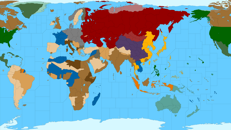
Proposed Map: Domination 1941
-
I think with "Fog of War" you'd need some sort of surveillance/espionage component that would allow a certain chance to detect Enemy Forces.
Otherwise, at game start, as Cernel mentioned above, the Attacker could concentrate and the Defender would almost be forced to max protect there most valuable area as they can't defend it all. Most likely anyway. Would definitely need some tweaks.
It'd be a lot of fun finding them though
")
Edit
Actually one should be able to see who is adjacent to you. So, behind the lines so to speak, would be where the "Fog" would come in.Where are those damn Panzers !!! lol
Even then you could go with probabilities. Especially game start
-
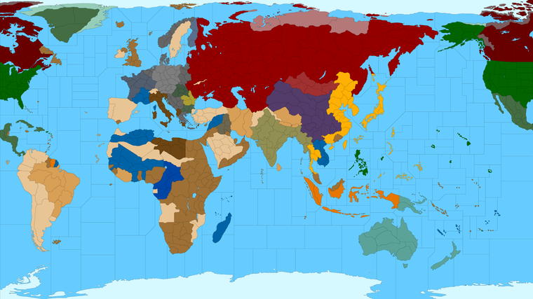
Ok so how does this feel for G40 sz divisions?
I did the blocking so the connections would be the same, I think hehe. I tried to preserve some of the sweep of the OOB sz shapes without having to move too many islands/TT out of position. Obviously there's a fair bit of distortion on the South Atlantic/Pacific OOB, but I tried to get close. Let me know if I goofed anything major.
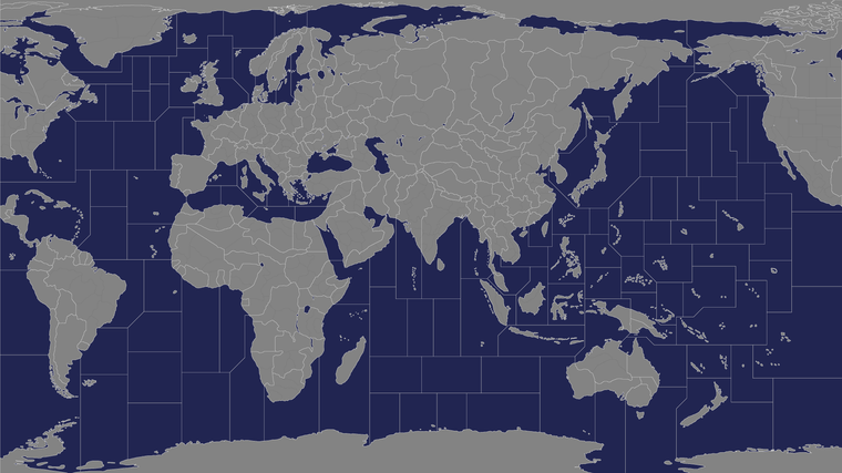
https://www.dropbox.com/s/9f3tanjxa2485uo/TripleA_4k_baseline_G40_sz.png?dl=0
So what I tried to do, was give us some options to bisect various sz in half, so that they could split islands or just to add another zone. So the smallest tile shown above for each ocean, would be about as small as one would want to go for that. Right now they can each fit about 18-24 unit typesat 54px depending on how tight we want to make the centers.
-
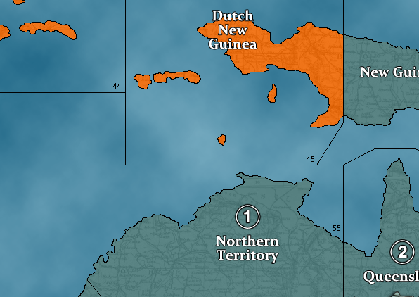
@black_elk you need to add one more off Northern TTy so Celebes farther away
-
@beelee Good eye! Geez that's sort of a weird one isn't it lol
OK what if we went for something more like this? Little more room for the ships that way too.
https://www.dropbox.com/s/9f3tanjxa2485uo/TripleA_4k_baseline_G40_sz.png?dl=0
Here is the bitmap with all the extraneous borders removed to just show the G40 lines.
https://www.dropbox.com/s/1j7omf0s69t1r3k/TripleA_4k_G40.png?dl=0
-
@black_elk That looks way sweet
 Plenty of room to mix it up. Dutch boys can even join in lol
Also got room for the Ancient Alien nazi base in Antartica lol
-
Word! heheh
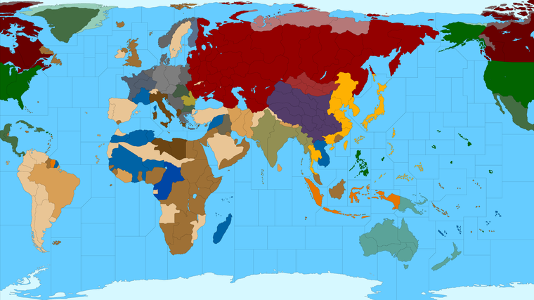
Here it is with a quick G40 paintjob. Borders should be closed up proper now
-
@black_elk Am I understanding correctly this is supposed to be a map-skin of WWII Global? Meaning that it gives the same game as the original, just with a different visual.
If so, the non-Dutch part of New Guinea should be a single territory.
-
@cernel Ah thanks! I'll fix it in the baseline right now
Yeah that was the idea. First get one that looks aces for Global.
Then we can make another version with subdivisions once we know that G40 one looks correct. At least in terms of the connections and such!
Ok got it, fixed the bitmap image in the dropbox link and the painted reference post above. Let me know if there's anything else you see that I missed.
https://www.dropbox.com/s/1j7omf0s69t1r3k/TripleA_4k_G40.png?dl=0
Catch you guys tomorrow!
Best Elk
ps. here's a more 40-into-41-ish vibe on ownership, but with the 'regular' G40 TTs.

-
If there will be another version with subdivisions;
Japan is shown to close to Vancouver as much as it is to Vietnam. Northern Pacific can be shrinked for gameplay reason. But if realism is the top priority, Japan should be closer to Vietnam than Vancouver.
Also you might want to divide Southwestern Dutch Guinea because Japan never captured southern part of the island.
-
@schulz Here it is with those earlier tiles overlaid with the White/Black switch again.
For the Pacific, my impression was that by shrinking the Americas in A&A, the idea is that all those coastal sz tiles represent much larger distances than the tiles in say the South Pacific.
The warp on this area of the OOB board is even more extreme than in Europe, with the North Pacific compressed by almost 50% and the South Pacific enlarged by almost 50%, and obviously many of those smaller islands and sz are made fairly gigantic along the way OOB hehe.
I'm not sure of the best solution if what you want is just to have Japan even further from Vancouver, beyond expanding the width of the entire board in that area. It's possible to insert more ocean, east of Hawaii if one wanted. It's also possible to slide the Americas down a bit, which might create a similar effect. My main goal was to minimize unnecessary dead space in the oceans by focusing the warp on the areas of major activity.
I guess I was definitely prioritizing gameplay over realism there, or at least trying to find some sort of happy medium between the OOB gameboard and the real world.
I'd think maybe the best approach would be to create the impression of more distance by inserting more sz tiles. Or else to increase the width of the map slightly, which kinda throws off the 16:9 aspect, but then maybe maybe that's not super important anyway. I'm not sure how much of the Antarctic region in the far south one wants to retain either. I don't like scrolling past too much deadspace on the map myself, especially when you're right on top of it. So if the distances feel more abstract anyway, and it's more important to just be able to see what's happening at a glance, I kind feel like we can get away with it, provided the Pac is at least still wider than the Atlantic at a glance. That might just be me though and more the way I play. I think OOB and Bung's version both show a ton of compression on the West Coast of North America. Since I didn't distort the shape of North America as much, it's probably reading a fair bit larger and contributing to that sense of the shorter distance. They're not that far off actually, this map compared to Bung's, but the rest of the West Coast is shaped pretty differently here than in OOB, you know where Mexico displays like North of Japan lol.
I'd say for every large sz or sz with an island, we could try to do some splits and see how it starts shaking out.
If ya got any thoughts on fun splits for the sz divisions, bang out the red marker and we'll go to town hehe
")
-
@black_elk
Im not a A&A player, but my 2p, your aim of gameplay over real distance is a winner for me. There is enough SZ and islands to make for a very interesting island hopping pacific game.Japan is sitting in one large SZ, should it be split along the axis of NNE to SSW to make it a West SZ & East SZ ?
https://forums.triplea-game.org/tags/thedog
https://forums.triplea-game.org/topic/3741/curated-best-top-maps-triplea-guides -
@black_elk If the main goal is playability and eliminating useless sea zones then the current distances are fine.
-
Yeah those are the definitely good Qs. I mean it would make sense to me to have some SZ coming off Japan sorta like rays of a sunburst and then to give them a protected drop back spot or just more variety in the approaches there. And then for basically all the major island chains to have a SZ that bisects the islands, so the chain become more strategically usefully for aircraft movement around the map. That'd be my thought.
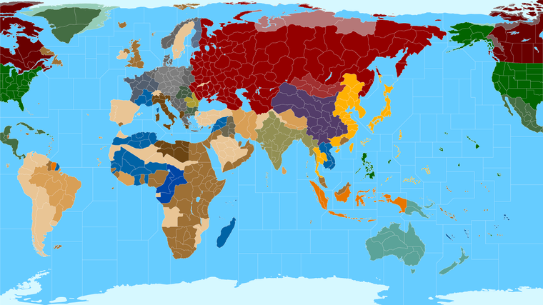
Here's the biggie with those land subdivisions again, I still think any of those could get tweaked, they're just roughs from the earlier draft... I find that if I open the map and look at it at 100% like that, really cozy up, it feels like there could be many more sz arranged around the board.
https://www.dropbox.com/s/6d719ncdzub7lli/TripleA_4k_Domination_1941_painted.png?dl=0
Here it is back in black line... needs some clean up from the G40 tweaks, but gives an impression.

white lines
Here is one of Hepp's concepts that shows many of the tiny islands bisected and of course the convoy lanes that he had for 1914...
Perhaps something more in keeping with that style would be fun. And more Domination-esque than the G40 style blocks. But I just wanted to get us off to a good start


Hehehe
Catch ya next round
-
@black_elk sweet makes me wanna roll a tippy top cigarette now lol
-
Always! lol
So I started laying down some lines for further SZ divisions in ways that struck me as potentially interesting...
https://www.dropbox.com/s/tugjcvsb5y106rl/TripleA_4k_Domination_1941_painted_more_sz.png?dl=0

The goal wasn't necessarily to increase the distances by inserting more tiles, but more to create a few different ways of getting from point A to point B, and to highlight some of the islands, and generally just to give ships more places to go. I figure if money is attached to sz either directly to all or with specific convoy type zones, then it's good to have some that are more for the cat and mouse or like naval blitz/picket type dynamics. For islands, usually it comes down to making them more interesting as landing pads, whether for ground units being transported or aircraft. Obviously we could insert more tiles than this or try to do it in different ways, but just wanted to start laying down some lines. Some sz are more strategically useful, some are more like transits, but I thought that idea of randomized sub spawning in the Atlantic had promise, so I put a few spots down with that in mind. Let me know what you think or if you have ideas for the layout. I tried to maintain some visual interest in the shapes, so it wouldn't be just a series of rectangles, but clearly there are still quite a few of those haha.
-
I've found the map visually very appealing. Especially white borders and national colours look very nice. Except Japan. Bright yellow looks not very eye-friendly to me.
-
I think Turkey and Saudi Arabia can be impassable. But probably it is better to keep their territories because this map has also potential to be a WW1 mod.
-
Does English Channel touch the German coastline? I think it shouldn't.
-
Northern Tyrol was part of Germany.
-
I would really suggest not making Germany-Belgium-Paris route longer than Germany-Lorraine-Paris route. Alsace-Lorraine should be separated.
-
Italy had Italian East Afrca until November 1941.
-
Montenegro and Southern Slovenia were part of Italy. I am not sure if Croatio and Bosnia should be part of Italy. @Cernel ?
-
-
@schulz said in Proposed Map: Domination 1941:
I've found the map visually very appealing. Especially white borders and national colours look very nice. Except Japan. Bright yellow looks not very eye-friendly to me.
-
I think Turkey and Saudi Arabia can be impassable. But probably it is better to keep their territories because this map has also potential to be a WW1 mod.
-
Does English Channel touch the German coastline? I think it shouldn't.
-
Northern Tyrol was part of Germany.
-
I would really suggest not making Germany-Belgium-Paris route longer than Germany-Lorraine-Paris route. Alsace-Lorraine should be separated.
-
Italy had Italian East Afrca until November 1941.
-
Montenegro and Southern Slovenia were part of Italy. I am not sure if Croatio and Bosnia should be part of Italy. @Cernel ?
@schulz Sounds good!
Sorry I detoured a fair bit from the ground game just thinking about sz lol. Didn't get around to the channel yet.
If I goofed the paint bucket we can fix it on the next run. Here I blocked it in a few lines real quick so I wouldn't forget for next time, but we can fix em up tomorrow.
The line in France probably got erased when I was redrawing Germany. We can add back in. Whatever works. I figure we just keep chipping away at it till it feels good all around, then cook something up for Turkey day maybe? hehe
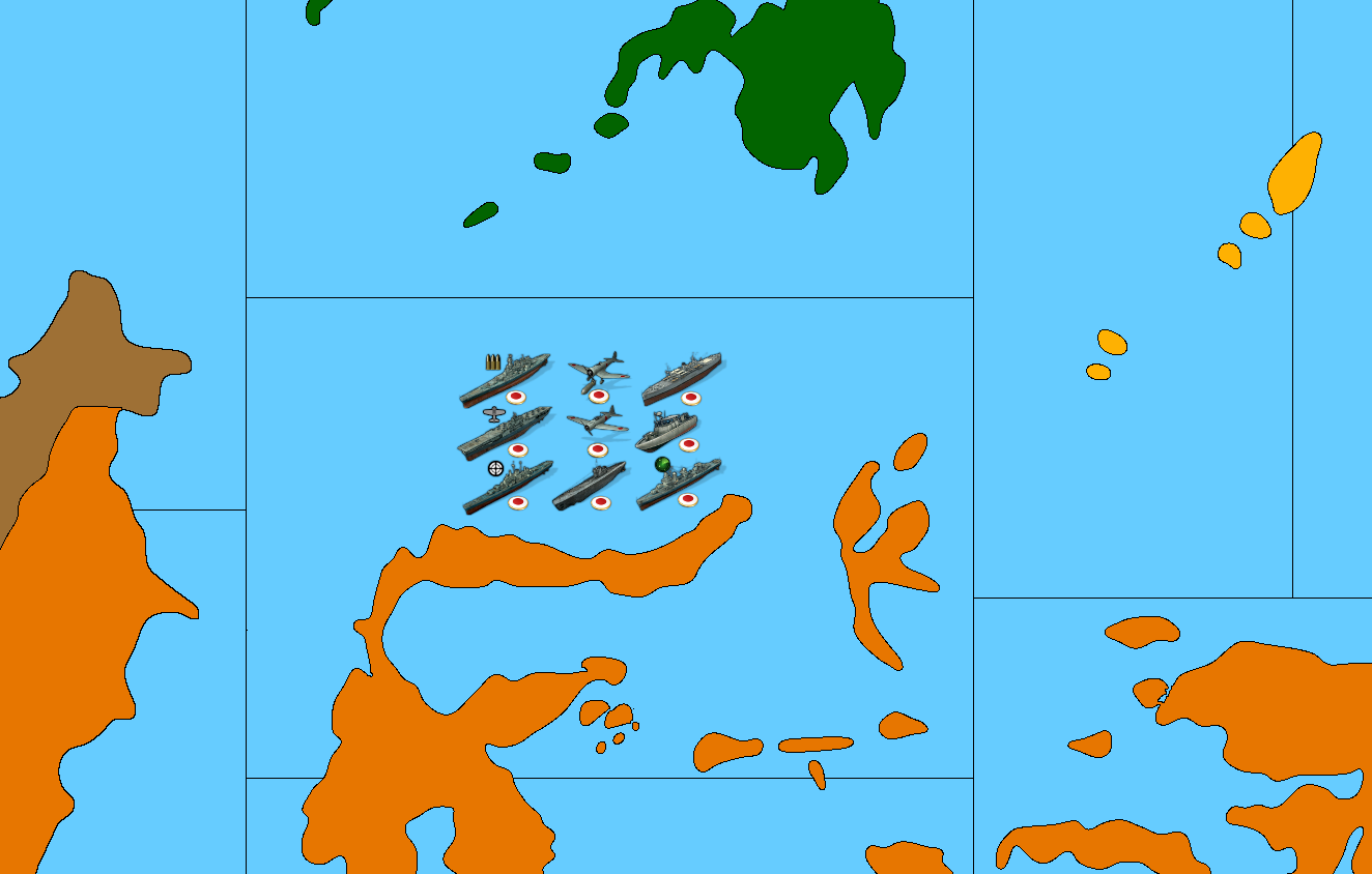
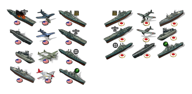
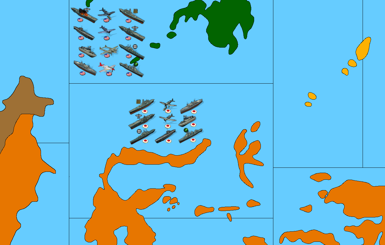
There I tossed the Americans in there on the Celebs detail just so you could get a sense of scale with units.
-
-
@black_elk
Be careful in the English Channel London-Berlin is 4, return 8, Bombers move 8.
It could be move 10, but that puts a strain on the AI and could make Bombers even more powerful.https://forums.triplea-game.org/tags/thedog
https://forums.triplea-game.org/topic/3741/curated-best-top-maps-triplea-guides -
Updated feature list
https://forums.triplea-game.org/topic/3326/1941-command-decision-domination-1941-code/3
Thought I would keep it seperate as this is a very busy thread.
-
@thedog said in Proposed Map: Domination 1941:
@black_elk
Be careful in the English Channel London-Berlin is 4, return 8, Bombers move 8.
It could be move 10, but that puts a strain on the AI and could make Bombers even more powerful.You may as well say that bombers should move 12, because the English were also bombing Genoa (and a few other cities in northern Italy), which, from England and back, is a 12 zones movement.
Also, I think it's not clear where Milan is in the map. It seems to be about at the tripoint where the boundaries of the three northern Italy territories meet.
As I said, I would get rid of the very small territories: merging north Tyrol with Carinthia, merging south Slovenia with Italian Croatia and merging north Slovenia with German Croatia.
Whereas all Greece can be shown as German as a matter of who is getting its production value (since it was the Germans which were robbing it blind, leaving the scraps to the Italians), if the Peloponnese is Italian, I would show also middle Greece as Italian, thus getting close to the actual occupation zones. I believe Athens itself was under the combined occupation of Germany and Italy, and I agree with not representing it separately.
@Schulz A lot of Italian Croatia was factually in the hands of the communists. Croatia itself was a failed state in civil war between Croatian nationalists and Croatian communists, with the communists clearly getting the upper hand because of popular support, so this rump state was divided between the Italians and the Germans (because the Croatian nationalists proved unable to control the territory on their own as it was hoped they would be able to) but never formally liquidated.
Hello! It looks like you're interested in this conversation, but you don't have an account yet.
Getting fed up of having to scroll through the same posts each visit? When you register for an account, you'll always come back to exactly where you were before, and choose to be notified of new replies (either via email, or push notification). You'll also be able to save bookmarks and upvote posts to show your appreciation to other community members.
With your input, this post could be even better 💗
Register Login