Axis Ascension
-
@schulz said in Fortress World 1942:
- Do you think should Germany be divided? Dividing Germany will make a lot harder to defend W.Germany, E.Germany and France.
I already answered this, and I don't have much else to say. If you think that (in your map) the Axis player can still win after Germany is taken, I guess you should split it at least in two between the historical Sovietic and non-Sovietic occupation zones. I think a single piece Great Germany (like in all small basic maps since Classic) looks great, however, and simplifies game-play nicely.
- I am kinda annoyed with the fact that Germany usually isn't capable of reinforcing Norway with land troops which results very easy invasions from the British. What about making the Danish stratis canal? Germany will be able to keep a navy in the Baltic Sea more safely plus the ability of reinforcing Norway.
I tend to think they should be a canal but passable if each side holds a side (so a weaker canal in which you only need one side to move through (and, by the way, a similar matter would apply to the Dover Strait: no Channel Dash after the Allies conquer France)). However, Germany may be still unable to reinforce Norway if it is easy for the Allies to have or to escalate air units able to kill all German transports in the Baltic. Alternatively, you can have the Germans being able to non-combat-move units via air to Norway.
- Do you think should Sahara Desert really be represented?
Not the desert as a whole, of course: only the sand-seas are virtually impassable. The main ones are El Djouf, Erg Iguidi and Chech, the Grand Occidental Erg (wich can be represented as a single sand sea together with the contiguous Iguidi and Chech), the Grand Oriental Erg, Idehan Ubari, Idehan Murzuk (there is a very slim passable corridor cutting through these two, the main hub being the city of Murzuk), the Ramlat Rebiana, the Great Sand Sea (which can be represented as contiguous with the Ramlat Rebiana, practically making the Ramlat Rebiana part of the Great Sand Sea). Another candidate may be the Erg of Bilma, but I don't personally consider it to be a proper sand sea, so I doubt I would have it as impassable, but it's disputable. Of course, also don't forget the salt flats, which are about as impassable as the sand seas. Obviously, the most important salt pan is the one south of El Alamein (which is continued eastward by an adjacent sand sea), which is nearby but not contiguous with the Great Sand Sea (as there is a small strip of passable land whose main hub may be the settlement of Bahariya). Also the one almost cutting Tunisia in two is obviously important. Moreover, don't forget to do the same for the sand seas in Arabia (two main ones and a sand sea strip which almost connects the two nearby Riyadh) and, of course, the about as big Taklamakan desert, which is actually two sand seas split by the Khotan river, of course. I'm thinking the only non-African very important salt pans are the one between Pakistan (of course, not called as such at the time) and what is now India near the coast and the one south-west of Afghanistan. All the other ones should be pretty small for the size of your map. Also I guess the sand seas between Ningsia and the Kansu corridor may be too small to worry about in a map like the one you have. Other impassables are the big lakes, of course. Three big ones in Africa, two in Europe, four in Asia (counting also the Garabogazköl), all the great lakes between the United States and Canada plus two or three other ones in Canada itself. I think South America has just a few small salt pans and no deserts, so I think impassables are not needed there (unless you want to do something about the Amazon, which would then require being consistent with similar jungles in other parts of the world), and I would say that none of the Australian deserts is really impassable, especially in a map like this one. A questionable one is, of course, the Changthang, which is, however, not impassable per se (but it has almost no population and virtually no infrastructures).
- Is it better for all naval units moving 3 rather than 2?
You need to decide how long is a single round (1 month or what?), then set naval movements realistically.
- What about merging Sardinia and Corsica?
It seems reasonable in a map like the one you have. Of course, this should imply being at all effect the same as removing Corsica from the map: just be careful that Corsica is not adjacent to anything to which Sardinia is, to make the most sense.
-
I agree M3 Japanese ships might be really broken. OTOH USA would be way too slow to participat battles. Especially the Pacific front would take forever.
Maybe all ships can remain M2 while only USA ships can move 3? Would it be confusing or better?
Another alternative is combinin the British Empire and the US. But it would be probably super broken.
-
-
Actually maybe Denmark and Southern Norway can be merged and this single territory might be canal. The correct answer might be found in an alternaive history. Could Germany have reinforced Norway in WWII via Baltics if the Allies attemted to take it?
-
I think 1 round will represent 2 months. Normally I am fine with 2 movements but USA would be way too slow.
-
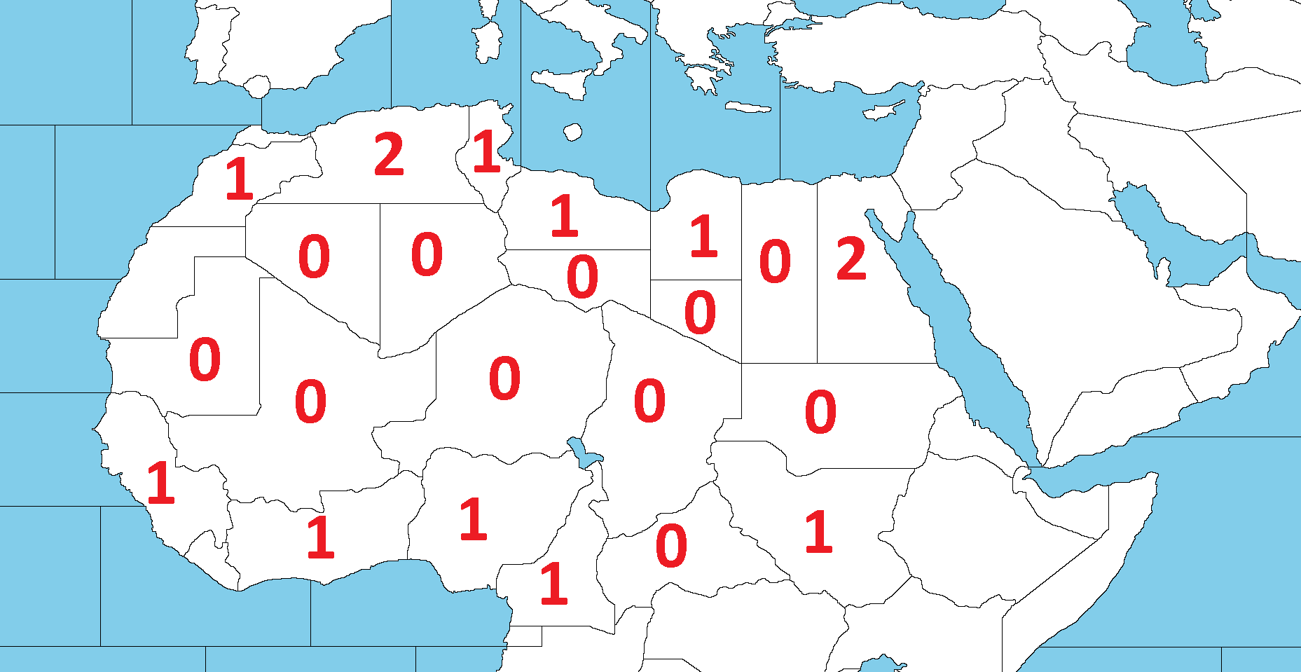
In sake of simplicity, I just decided to make only neutral countries impassable. Sahara can be represented with a bunch of valueless territories like this.
-
-
@schulz said in Fortress World 1942:
- Actually maybe Denmark and Southern Norway can be merged and this single territory might be canal. The correct answer might be found in an alternaive history. Could Germany have reinforced Norway in WWII via Baltics if the Allies attemted to take it?
I doubt they could have had unless Sweden would have allowed passage or would have been conquered. I assume Helsinki has a good enough port, but it looks like that all railways connecting Finland and Norway go through Sweden. However, I'm not seeing Sweden as anything difficult to conquer for Germany, and it may be bullied into allowing passage through its territory (and the Germans actually did so albeit not systematically).
- I think 1 round will represent 2 months. Normally I am fine with 2 movements but USA would be way too slow.
If we take a strategic speed of half the maximum speed, so, let's say, 6 knots for transports, 14 knots for battleships and 17 knots for cruisers and aircraft carriers, over a period of 2 months (approximated to 61 days)
- a transport should move 16,000 km.
- a battleship should move 38,000 km.
- a cruiser or aircraft carrier should move 46,000 km.
On the map you have, we can approximate it as that
- a transport should move up to 12 spaces per turn.
- a battleship should move up to 28 spaces per turn.
- a cruiser or aircraft carrier should move up to 34 spaces per turn.
Here ya go.
-
@cernel They are crazy numbers . Game would be unplayable due to impossibility of naval calculations.

-
@schulz I've actually been very conservative. If you would take a speed of 10 knots for transports, that would be 27,000 km in two months. Going from Scotland to Alexandria around Africa is a voyage of about 22,000 km and in your map that would be a movement of 17. Multiplying 17 per 27 and dividing it by 22, you could say that transports should move 20 spaces per turn, and then you could set units like cruisers and aircraft carriers (which move about 3 times as fast as a transport) at moving 60 spaces per turn. My previous proposals are really the minimum movements, calculated in a very conservative way. So really nothing crazy at all.
-
@cernel Game also has no railway. All units move on foot. It makes sense to me to reduce the speed of naval vessels to balance slowed down land units. 20 moving transports would make landings on enemy territories unrealistically way too easy. Maybe we should take into account the speed of naval vessels in 1700s.
-
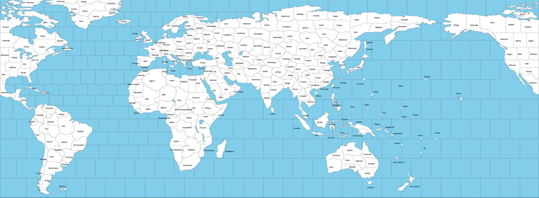
More accurate names are welcome.
-
@schulz really coming together
 seems kind of odd greenland should have so many territories tho
 -
@ubernaut Considering the Germans did invade Canada during WWII (https://www.cbc.ca/archives/the-secret-weather-station-the-germans-built-in-labrador-during-wwii-1.5357840) Greenland can be a very important battlefield.

Joke aside, its the same reason why Brazil isn't a single territory. Its just aesthetic and coherence.
-
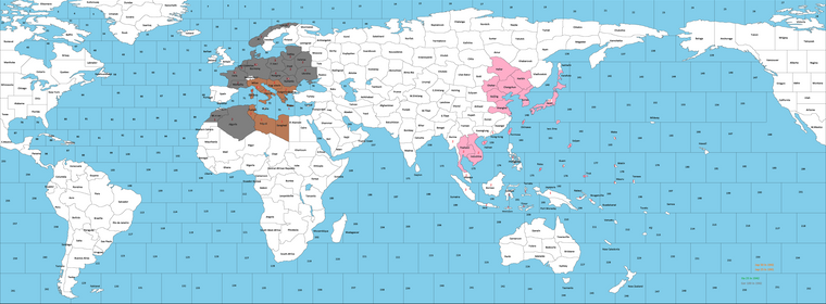
I was appointing hypothetical values for territories. The goal is compromising realism and playability asap.
-
In 7 Dec 1941 (Japan will need to be the first to play) Japan is just as powerful as Italy (Both are 25 Pus). Japan can become 2 times as powerful as Italy with the following historical conquests (Japan reaches 50 Pus)
-
Japanese controlled Chinese Territories, Korea and Karafuto are worthless to represent the non-existent Chinese front.
-
Germany (100 pus) is two times as powerful as Italy and Japan combined.
-
No upkeep this time, but units will be two times more expensive to reduce massive stacks. (infantry=6, artillery=8, armour=10 etc...)
-
I tend to not make USA ships faster than the other ships. But considering the massive distances (There will be probably no Hawaii factory), USA transports should be really a lot cheaper. I think ideally a USA transport can be 4 Pus while the other 12.
-
I have no idea yet how to distribute the Allies income to have a relatively balanced game considering lack of China and Soviet-Japanese war.
-
-
I've tried several times to create a relief tiles. But I couldn't make anything.
Is it easy to get AA50 style relief tiles?
Here is the full map.
-
I'm not sure, but I think the pattern used in Revised v5/6 Global might be a built-in? I replaced my v3 relief with WOPRs version for AA50, since I like that one a bit better than seeing the political leaders. Though some of the graphics in the standard one were kinda cool like if it's showing fighters or ships or whatnot, but I found the faces distracting hehe. I'm not sure there's a quicker way to do it, but basically you'd take your map image into GIMP or PS or Inkscape and get transparency layer going where you can add design elements or images and then play with the opacity. What ends up displaying for the player would be that stuff when they have the details turned on.
-
@schulz said in Fortress World 1942:
I've tried several times to create a relief tiles. But I couldn't make anything.
Is it easy to get AA50 style relief tiles?
Here is the full map.
It may be advisable waiting on making relief tiles until the map is extensively play-tested. Relief tiles are, unfortunately, a huge burden in redrawing the map once they are done and may discourage further tweaking.
-
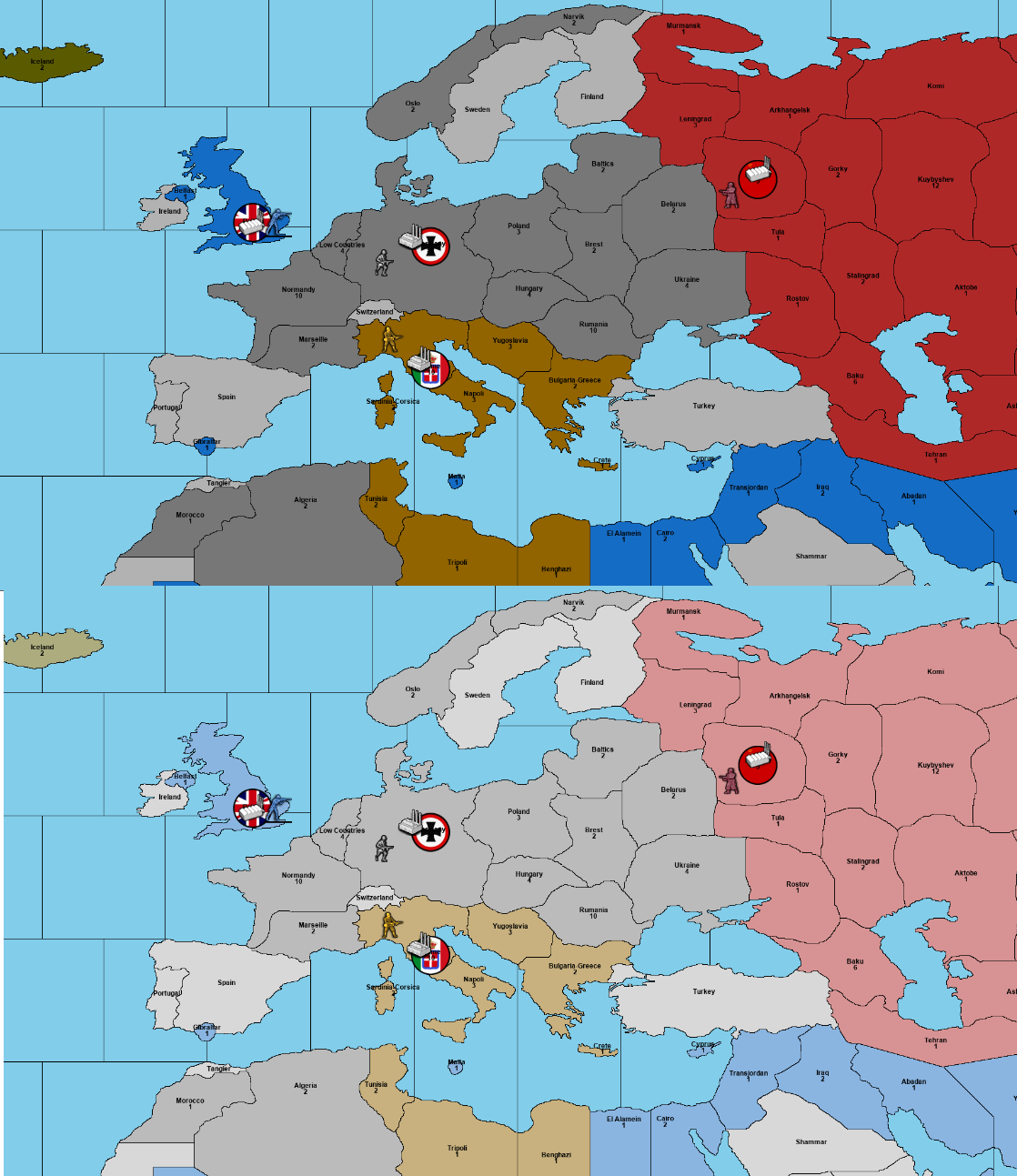
This is how Europe looks like without relief and with a fake relief.
I have still a few doubts about balance.
Here is the stats of Dec 1941.
Japan: Starts with 25 ipc but becomes 50 ipc power after completing its historical conquests. Has an unbreakable non-aggression pact with the Soviets. No Chinese front.
The Soviets: 50 ipc. Allies units cannot enter the Soviet soils.
Germany: 100 ipc (50 ipc from Germany but probably need to be changed due to the vulnerability of strategic bombing.(Allies can abuse strategic bombing if Germany worths more than 20 ipc) 20 ipc can be removed and 2 German subs could be randomly spawn in the North Atlantic. I am not sure if the AI can handle this. Another method is making Germany 20 ipc and adding 30 ipc as a national objective.
Britain: 100 ipc but will lost 21 ipc if Japan reaches its historical conquests.
Italy: 25 ipc.
USA: 75 ipc.
-
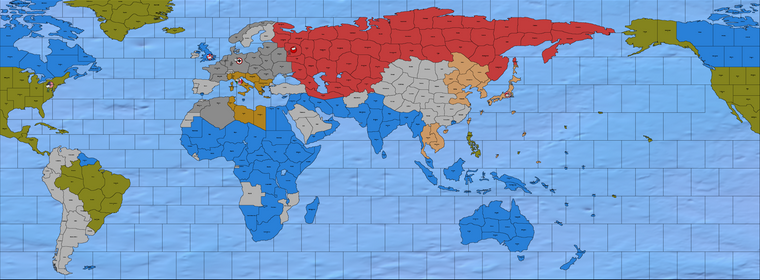
I think I'have made a decent relief for sea zones. But creating a relief for land territories is a whole other beast for me right now.
Here is the new base image
https://i.ibb.co/ZG2zgyM/fortress-world-sea-relief.png
And an incomplete relief with stroked lines only.
https://i.ibb.co/xMT8KW0/fortress-world-transparent-stroke.png
-
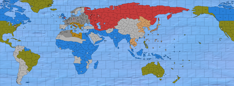
I think adding the Danish straits is necessary for gameplay reason. Same as having ANZAC part of the US rather than the UK. Sydney worth only 3 ipc so USA would still need to use California factory to reinforce the Pacific.
Balance is the complicated part. I mostly try to mimic v6 set up. But still progressing.
-
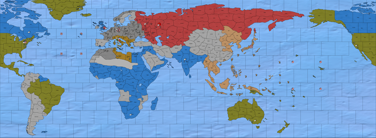
-
Kuybyshev is the capital of the Soviets.
-
Incomes are collected at the start of rounds.
-
Iran had to be impossible otherwise AI Britain tries to reinforce the Caucasus even though they are not permitted to enter the Soviet soils.
-
The flagged sea areas are naval points which has a 25% to spawn a submarine each round. Unfortunately they spawn at the end of rounds to not break AI compatibility.
-
At what point should the Axis start outproducing the Allies for a balanced gameplay in your opinion? Currently; If Axis holds all their starting territories, takes Baku, Rostov, all the Mediterranean and a few extra Pacific Islands, they start outproducing the Allies.
-
-
Could anybody provide me the location of major power's navies and their situations based on April 1942? Maybe I could implement it in my scenario.
My second question is; Was being defensive in naval warfare advantageous as much as it was in land warfare? For example, it is realistic for destroyers, cruisers and battleships having the same attack and defense values?
-
@schulz It was advantageous for fleet to be operating close to its bases primarily because of air cover. Scramble rules for air bases show this well.
You may want to give a large movement bonus to ships starting at a friendly naval base.