Need Relief Tiles
-
@Schulz wether they are forbidden by triplea or Germany or not I would not be interested in having them on my machine or working on them so yeah…
-
To be clear about Nazi symbols in Germany:
As far as I understand it the usage of course is still forbidden. There is no general "lift of the ban".
However there are certain exceptions when their use is allowed, for example for purposes of culture, education, science.In case of computer games an authority called "USK" decides on a per-game basis whether the usage of those symbols might be allowed or not.
-
@ubernaut I can remove the swastika in an update.
-
@Schulz having some difficulty finding color images that are creative commons how do you feel about black and white for the faces?
-
@ubernaut Really can't say anything without knowing how would they appear on the map.
@MirkoBruner has created the the relief tiles for ground which inside on the zip, feel free to improve somethings if necessary or adding portraits hence we can see how would they appear considering new slighly lighter Russian and Italian colours.
-
@Schulz i think if he did the relief tiles already he would need to add the images since you need the intact version of the map in order to do that.
-
@ubernaut Do you know how to create transparent ipc and territory name v3/v4/v5/v6 style? Were they all obtained from a website?
-
@Schulz you mean the font?
-
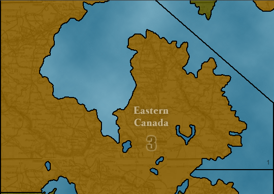
Yes, wondering how do I get the same decorations with "Eastern Canada" and transparent "3" ipc.
-
@Schulz not sure what that font is but its fairly similar to times could be century. the transparency is just done in the relief tiles like any other graphic effect using photoshop or something like that.

-
-
@Schulz The Transparent Names and Territory values are not part of the reliefmap, the images of the Territory values are stored in the folder PUs and if you name them 1.png, 2.png etc they should work automatically.
The files for the names are stored in the folder misc and you have to reference them in the decorations.txt file.
For examples look at the structure of the ww2v3 game (AA50) where the image name and location are in the decorations.txt file:
Western_United_States.png (3529,406)
Yakut_S.S.R..png (2209,232)
Yunnan.png (2182,860)
etc...
So you would have to create seperate image files for the territory names and values or otherwise triplea will fill that in automatically
Greetings, Chickenman -
@The-Chicken Thanks I have already knew that. I was looking to learn that how to generate these non-transparent territory names and transparent numbers.
-
@Schulz i don't see why not.

-
@Schulz I am writing to you, let me know.
-
The game has now relief tiles.
-
@Schulz I am studying other maps, while yours is one piece only, common maps are made by tiles of the size 256X256 Pixels. I don't know why is that, but there must be a reason, ask fellow developers, at the moment I am re-designing the map of Global.
Regards,
-
@MirkoBruner The map creator engine always divide tiles of 256X256 pixels regardless of the map size or default zoom rate as far as I know.
Also I am thinking that @ebbe 's project has really good shore reliefs which maybe you could consider to do it for global.

-
@Schulz Nice, I have added to shades of "shores" so far but I still don't know exactly what it would be the best approach. Thanks!
