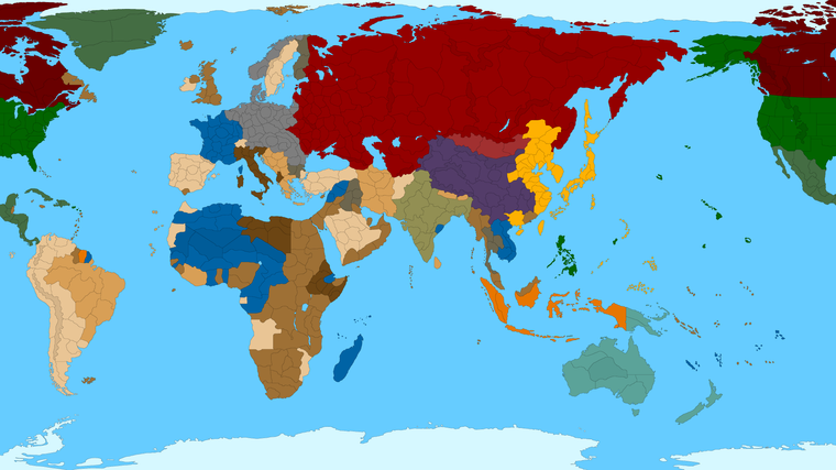
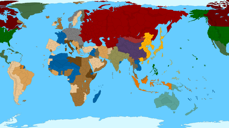
Proposed Map: Domination 1941
-
-
In my last post, I left a problem unsolved: tech systems. So back to discussing that!
")
I envision units being grouped into the following categories.
- Infantry (Light infantry, regular infantry, heavy infantry, possibly mechanized infantry)
- Artillery
- Tanks (15 ton, 25 ton, 50 ton, 75 ton)
- Single engine piston aircraft (fighters, dive bombers, torpedo bombers)
- Multi-engine bombers (medium bombers, strategic bombers, Superfortresses)
- Jets (Jet fighters, jet fighter bombers, possibly the flying wing)
- Surface ships (Destroyers, cruisers, battleships, Yamato battleships)
- Aircraft carriers (Carriers, fleet carriers)
- Subs (subs, possibly Type XXI U-boats)
The goal is to encourage players to build as many of these categories as possible. If the Soviet player doesn't want to build aircraft carriers, that's fine. But I do need the Soviet player to build infantry and artillery and tanks. I don't want the Soviet player to say, "I'm pouring all my research money into infantry and tanks. I won't be researching better artillery, and I won't be building new artillery."
For that matter, there is another problem. Late in WWII, Germany deployed a small but significant number of jet aircraft. Had the war lasted another two years, the proportion of the Luftwaffe consisting of jets would almost certainly have increased. Britain and the United States also deployed jets during the war, albeit in small numbers.
How to create a situation in which those nations, and possibly Japan, are allowed to deploy some jets, without allowing them to ahistorically switch all their new production over to jets? One way of accomplishing that would be to limit jet unit placement. If you upgrade a manufacturing facility into a jet manufacturing facility, you can place one jet per turn. If you have four jet manufacturing facilities you may place four jets per turn. There is a nation-dependent and tech-dependent limit on the number of jet manufacturing facilities you can have. This way you're allowing 3 - 4 nations to build jets, without allowing them to swamp the skies with jets.
Nations will build infantry, because manpower points can be used only on infantry. If using a straightforward tech system, that leaves the following unsolved problems:
- If a nation is in a major land war, force it to build both artillery and tanks; rather than choosing one or the other.
- You want Britain and the United States to have strategic bombing/bombers research as a viable path, instead of dumping all their air research into single engine piston or jets.
- In the Pacific, you want the U.S. and Japan to build a combination of surface ships, aircraft carriers, aircraft, and subs. Actually, I'm okay if the American player neglects subs, but other than that I want to see a mix of those things getting built!
A couple ways occur to me of solving these problems
- Lump tech categories together. For example, tanks and artillery could be lumped together into the same category. Likewise for carriers and surface ships.
- Give a nation bonus units of one type in exchange for building units of another type.
The former idea doesn't sit well with me. It means reducing the number of tech categories; and hence, reducing the amount of strategic choice associated with the tech system. That leaves the latter idea: giving nations different-category bonus units. Let's discuss that a bit to see how it might play out.
Suppose you tell the U.S. and Britain: "For every ten single engine piston aircraft you build, you will receive one free strategic bomber. Once the U.S. learns to build Superfortresses, the American bonus changes to 1 free Superfortress for every 12 single engine piston aircraft." Likewise, Germany and Japan could be told, "You receive 1 free medium bomber for every 5 single engine piston aircraft you build." With something like this, you're creating a situation in which those four nation will have multi-engine bombers coming onto the board, and therefore will receive a benefit by researching multi-engine bombers tech.
You could do the same thing with land units. For example, you could take the Soviet player aside and tell him, "For every 3 medium tanks (25 ton) you build, you receive a free artillery. Also, "For every 3 artillery you build, you receive a free medium tank." With something like that, you're ensuring that any nation engaged in a major land war will always be building a combination of tanks and artillery. And will therefore receive a benefit from both tanks tech and artillery tech.
Suppose the U.S. player builds 7 single engine aircraft a turn. Over the course of 3 turns, that's 21 single engine aircraft; and therefore 2 strategic bombers received. To achieve this there should be a counter. "You've built 7 single engine piston aircraft this turn, which means you're 70% of the way to receiving your bonus strategic bomber. Whenever you feel like building those last 3 single engine piston planes, your bonus bomber will arrive."
I don't feel the need to force anyone to research jet technology, or to build jet aircraft. Jet aircraft will be flat-out better than their piston counterparts, especially in air-to-air combat. They will provide significantly more bang for the buck. Players are welcome to respond to that however they like, as long as they're prevented from building too many jets.
With all this being said, I'd like to create another rough draft for a tech system. If you see ways it could be improved upon, modified, or even replaced with a better tech system, feel free to speak out!
- Infantry
- Artillery
- Tanks
- Single engine piston
- Multi engine bombers
- Jets
- Surface ships
- Carriers
- Subs
- Industrialization (increases PU income)
- Land production (decreases land unit costs)
- Air production (decreases air unit costs)
- Naval production (decreases naval unit costs)
- Rockets (improves your air units, and possibly some of your ground units)
With respect to the above list, there are two separate questions one could ask. 1) What did a nation achieve prior to December 1941? 2) What did it achieve after December 1941?
As of December 1941, the Soviet Union's tank design achievements were amazing. The T-34 and other Soviet tank designs were clearly, far and away the world's best. But what did it achieve after December of 1941? During WWII, it upgraded the turret of the T-34; resulting in the T-34-85. That tank had three men in the turret instead of two. Its 85 mm gun gave it a longer range, and better armor penetration, than the original T-34. Late in WWII the Soviet Union began producing small numbers of T-44 tanks. However, as late as 1950, 85% of Soviet medium tank production still consisted of T-34-85s. Why? Because the T-44 had too many problems, and was not a good enough tank to justify switching over. In 1950 the Soviet Union began producing T-54s at its Omsk factory. The T-54 was a good postwar tank design.
The T-34 was significantly inferior to German Panther tanks. The same was true of the T-34-85, albeit to a lesser degree. Germany's Entwicklung tanks would have been simple to manufacture and mechanically reliable. Based on my research, and on data which are often more limited than I'd like, my best guess is that Germany's Entwicklung tanks--especially the E-50 and E-75 Standardpanzers--would have been superior to the T-54. And would have gone into mass production much sooner than 1950! If the goal is to be historically accurate, the Soviet Union should start with much better tank tech than Germany. But Germany should be able to research tank tech at a faster pace than the Soviet Union.
Starting nations off at different tech levels is easy. But how to go about making nations good at researching specific techs? I'm open to suggestions. The idea which pops into my head at the moment is that if a nation is good at researching a tech, it should pay 2x the usual cost to get 3x the usual benefit. Also if you are good at researching a particular tech, you cannot research it two turns in a row, to prevent your tech level from growing too quickly.
With that in mind, below are my thoughts about which nations are good at researching which techs.
U.S.S.R.: Land production.
U.K.: artillery.
U.S.A.: artillery, multi-engine bombers, carriers, industrialization, air production.
Germany: infantry, tanks, jets, subs, rockets, industrialization.
Japan: industrialization.The Soviet Union did an excellent job of simplifying land unit designs, thus increasing production.
Later in the war, the U.K. and U.S. developed HEAT ammunition for their artillery.
The U.S. developed the Superfortress bomber late in the war, which is why I made the U.S. good at multi-engine bombers. The U.S. was the only nation with fleet carriers; hence the U.S. being good at carrier research. The U.S. doubled its air production from '42 - '44, which is why I made it good at both industrialization and air production.
Germany developed assault rifles and Panzerfaust handheld anti-tank weapons. (The later versions of which were much better than bazookas.) That's why I made Germany good at infantry. Germany being good at tanks is explained above. Germany is good at jets research because its jet designs were better than their British or American counterparts, and because its second generation jets would have been a major improvement over jets such as the Me 262. Germany is good at subs because of the Type XXI U-boat. That sub was ahead of its time. A number of Type XXI U-boats were in the working up phase when the war ended. Germany had the world's best rocket program. Germany is good at industrialization because it tripled its military aircraft production from '42 - '44.
Japan is good at industrialization because it also tripled its military aircraft production from '42 - '44.
The subject of electronics, of radar and sonar, is a tricky one to handle from a game play standpoint. In general, Britain and the United States had the world's best electronics, with Germany usually close behind. As the war progressed, American ships generally had an increasingly large electronics advantage over their Japanese counterparts. As electronics shrank, aircraft became increasingly sophisticated with their electronic and mechanical computational gear. How much in-game acknowledgement do I want to give Britain and the U.S. for this? Hmm. I feel like the U.S. has a big advantage over Japan already, due to the former's production advantage. Do I really want to make the U.S. good at surface ships as well? Maybe making Britain good at surface ships would make more sense, on the theory that British tech was good enough that it deserves more acknowledgement than just artillery, and on the theory that making Britain good at surface ships would be less disruptive to game balance than making the U.S. good at it.
Japan deserves credit for its Long Lance torpedoes. But I envision that being a nation-specific advantage. A bonus to Japan's submarines and cruisers.
-
I pushed the stretch about as far as I dared. I was able to get enough room for another 50 or so units in the Med, and twice as much room for the red sea. The distortion is basically occurring mostly there around Suez, so I tried to play that up a bit by dolling up the coastline where I could. I was able to scrape together a bit more room in France too, for like another dozen or so units on the coast. Normandy is still tight, but everything else is a little wider. I think going much further and it will start to look silly again, but since I was redoing the coastline and shifting continents in Western Europe, I took the opportunity to expand the SZ space around England by fair bit. So the North Sea and Channel are almost twice as wide now. I think it's about as good as we're going to get for ships. I'll tinker with Asia tomorrow
https://www.dropbox.com/s/5szkrvg5h90fb1x/TripleA_4k_baseline.png?dl=0
ps. I think it makes sense to carve back in a bit with Egypt. Just at the top portion of the red sea. We can probably fit a dozen or more units on the ground there. Not sure what's more important, ships or ground, but Egypt is usually pretty key, so probably make it a little beefier?
Here like so, done up with the ocean in blue, so it's a bit easier to see...
https://www.dropbox.com/s/9r09rmbyxcty80c/TripleA_4k_baseline_oceans.png?dl=0
pps. @KurtGodel7 just very briefly, I'm enjoying all these ideas regarding tech advances and reframing the game somewhat in that vein. I like that interlaced trajectory for a couple reasons, first and foremost because it keeps the endgame from becoming stale and predictable. Basically, you get a couple resets as the game develops if tech is sorta built into the gameplay as a constant. I think tech was always envisioned a bit like that, but the problem was that it became a wildcard you'd only play if losing badly, or winning roundly, and it was more like a one off rather than a progressive thing that kept building on itself. So I like that aspect the way you laid it out.
A Q to mull over would be whether you want these kinds of advances to be like automatic upgrades, or part of the purchasing dynamic too? Or I guess put a better way, do you want players fielding obsolete stuff, older tanks/aircraft until they're destroyed, or just like an insta up soon as the breakthrough is achieved?
The latter would be simpler I think and probably more in line with the Classic conception of tech advances, fewer unit types that would need to be displayed at a given time, though perhaps less realistic/historical in some ways.
Another thing that strikes me as kinda cool about the tech focus, is that (at least for the victorious Allies) the science and technology were the real spoils of war. Like when all was said and done, it was the scramble for that stuff, rather than hard reparations or money, that we were all obsessed with paperclipping up. So I like the idea of a game that could progress to that point more naturally. Not sure if capturing technology might factor into the scheme too, but just as an idea, I like it.
For the deep endgame, a possible final advance (where multiple techs converge) might be called "Strategic Weapons." It's sorta generic granted, for the Allies this would mean stuff like Atomic weapons, but for the Axis I think they might be framed more Bio-Chem. So Allies get the A's, Axis more the B's and C's. Once they've developed a means of delivery, say rockets or advanced bombers or whatnot. This could be like the final reset, where, provided the underdog can hang on long enough, they might get a chance to fight some kind of stalemate consolation prize. I think something like that is what's needed, a way to keep the losing player engaged. Otherwise people just quit at the halfway point, once they can clearly predict which way the wind is blowing. Not that it needs to be A&A 9 ball, but I like that possibility that either side might be able to eek out an honorable-apocalypse almost-victory of some kind, provided they fight on hehe.
Sorry that didn't fully touch on everything you said, cause I'm still looking it over, but just wanted to reply with something there. One thing I'd say, is that it's probably smart to pick a focus. Like if the game is going to be tech heavy, and very involved with that, and the unit interactions, and if we've already got a much more involved map (just in terms of the number of TTs and such) I think that's probably enough right there to make for a decent game. I think the player needs some kind of touchstone, so as not to get too overwhelmed, so whether that's familiar units or pricing at the start, or what, not sure.
But sometimes if I open a map, and I'm hit with too much at once, I tune out. That's why I really like the concept of a Larger game, but that plays a bit more like the Classic games. Without a ton of special politics or one off production rules anything of that sort. I'd say keep it super kiss with that stuff, and then the player has enough room to operate and can settle in to the new dynamics/ideas more readily, than if it's like an entirely different game right from the getgo. Not sure where I'm driving with that, but just the idea to have enough be familiar that the new doesn't seem too crazy crazy all up front. If that makes sense.
I've mentioned Iron War, and I really like that game, but it tries to do a lot at once. You got D10, an expanded unit roster with a different base price for infantry and relative cost for units (air-ships-ground), different naval unit interactions, Tech advances by game round, two resources (Fuel and Steel), factories that can be destroyed, several more factions, Atomic bombs at the end etc etc.
I feel like any one of those would probably be enough to keep me engaged, like destroyable factories, bingo that's almost enough by itself hehe, but doing all the rest of it at once, you gotta be pretty hardcore to keep pace. But that said, I think he also did a good job, given all that, of making some other parts of the game pretty streamlined, and as an SP game it works kinda brilliantly. Like there are no special rules, everything works the same for everyone. It even plays like oldschool revised in some ways, so it's not totally unfamiliar even then, but still. I'd say for a solid game, we keep it in the units
I like the national framing for the different technologies, where certain powers might have a path more laid out that catered to their historical strengths, and units that were actually developed. So not necessarily pigeon holed, but definitely with a flavor that doesn't swim totally upstream from the history. For my part I like when the first round or two or three rounds feel like the right sorts of things are happening in sequence. For the general playpattern, I like when there are incentives to go kinda along historical routes. You know like if Allies are pushing Atlantic I dig it when that goes sorta Torch first then into D-Day, as opposed to say Invasion Baltic States by the western Allies going all backwards hehe.
I think we could definitely do the No Western ground units in Soviet land as one option. I think the European Axis need to coordinate, but Japanese units in Europe are always kinda lame. The game is easily disrupted by friendly fighter defense, unless we do something to address that somehow. Strict rules get a little weird though where the teamate powers converge at the center of gameboard, which they should be able to do. The phrasing I like for no-friendly co-location of troops, is that it should be prohibited in starting territories. This solves a lot of problems with Japan globe trotting to Europe, or the Allies just stacking in the Soviet backfield, while still allowing for some spots where that can go down. Just as long as its sensible.
Another idea, more map related, but I think we could use some impassible coastlines to prevent the sort of direct amphibious invasion of Germany, while ignoring France, that often happens in A&A style games. So like maybe Holstein or Westphalia have a protected coastline forcing the Allies to go through Holland or whatever, rather than just landing units directly into West Germany with a big drop like "bang here we are!" already at the Elbe with no Normandy preamble lol. It might be slightly awkward in the reverse direction (like if Axis are ascendant and G is gunning for England and can't build ships super forward) but I think it'd worth the trade off there, just to prevent those kinda gamey amphib triple hit landings that always seem to be the way the Allies win in Europe. At least here Berlin isn't a coastal TT, but still you want a way for Axis to hold the line vs overwhelming naval drops, something beyond just building a million bombers lol.
Sorry this feels disjointed and rambly now, but just shooting from the cuff. I slept a few hours, probably going to take a day and let the new map sink in before diving back in again. Catch ya on the next one dude!
Here's the map repainted again, cause I wanted to make sure the new tiles were all closed...
I tried my best to get as much room as possible into Normandy and such, that whole coastal area really, where troops tend to stack. I think it should be a little more comfortable now for the units. Hopefully we won't need too many more major transformations, cause it's always a push and pull dilemma, invariably does something else unintended in the neighborhood hehe. I think this looks pretty reasonable though. Let me know if you see anything that jumps out.
https://www.dropbox.com/s/3cpi8ksdcnohpgt/TripleA_4k_baseline_oceans_repainted.png?dl=0
-
@black_elk said in Proposed Map: Domination 1941:
@beelee Yeah it's one of those things you almost wish was a mapview feature that could be switched on the fly. Cause it basically makes it easier to tell where the boundaries are when panned out.
I kinda prefer the black myself, but I'm also a bit of a minimalist when it comes to maps hehe. Some of my aesthetic preferences are showing here in terms of color choices, and a stripped down look, but I also think it should at least look decent with the details/reliefs turned off.
So here was my quick solution to the circles. Basically I just blobbed 'em, but tried to leave enough room so that those tiles could still fit a circle at like 200 px in diameter, like about the same amount of space. You know just so it can function for 1914-18 style games too if one wanted like with a roundel paintover or whatever, but more consistent here with the rest of the board, which doesn't have any circles. So Berlin, London etc they're still kinda circular in shape of course, but not like perfect circles, more like potatoes, which I think works a bit better for this one. Obviously we can clean that stuff up a bit, but again just to give an impression.
@black_elk I admire the work and the enthusiasm, but I didn't imagine I would ever see a map more distorted than Sieg's World At War on some relative distances in Europe.
A thing that - in my opinion - is very bad in World At War is the fact that Berlin is closer to Stalingrad than to Moscow.
Berlin - Moscow - Stalingrad is like the ideal triangle which is the strategic focus of any minimally historical WW2 game, although a better triangle (if the game strongly aims at realism) would actually be Berlin - Moscow - Baku: getting wrong the relative placement of such zones is likely the worst thing one can do in a WW2 game as far as map-drawing goes.
In World At War, while Berlin is unfortunately closer to Stalingrad than to Moscow, at least Berlin is closer to Moscow than to Baku (Azerbaijan).
In Domination, Berlin is as close to Moscow as to Volgograd and farther from Baku, which makes Domination arguably a little better map than World At War here.
Now, instead, I'm seeing a map in which Berlin is not only closer to Stalingrad than to Moscow, but in which going from Berlin to Baku takes the same total movement as going from Berlin to Moscow.
Whereas in this map the distances "Berlin to Moscow" and "Berlin to Baku" are the same (9 movements in either case), in reality they are, respectively, 1609 km and 3058 km!
Moreover, the mere voyage from Berlin to Moscow shows huge distortions: it is faster to reach Moscow from Berlin by going first south-west (!) for a while and thereafter all the way on a southern arc through Galicia and Donetsk, instead of moving through the realistically shorter route through Prussia, Vilnius, the Vitebsk province and the Smolensk province.
Here it is a visualization of what I'm saying:
Also, here Italy looks like a mix between WW1 borders and something it never happened. On the north, it is apparently missing Trento, Bolzano and Meran - all which were taken from Austria right after WW1 -, so it looks like it is the Italy which existed before WW1, whereas in the north-east it is so expanded into Slavic territory that it was not like that even after the conquest of Jugoslavia in 1941 (because the Germans took the north-eastern half of Slovenia for themselves, while here it looks like a situation in which Italy occupies all or almost all of Slovenia).
And Bulgaria in WW2 got a Mediterranean coastline only after the Germans invaded Greece (and, at that point, the Bulgarians also had enough of Jugoslavia (mostly in what is now North Macedonia) that they shared an extensive frontline with the also enlarged Italian Albania). So, this Bulgaria is not really representing anything at any single point in WW2 history.
-
@cernel Thanks for the feedback dude! So I think you're hitting on a couple different issues, that exist in tension and could be addressed in different ways.
So obviously we're in the process of repurposing a WW1 map here, that was itself a repurpose from what I'd drawn originally (mostly with the Official boards in mind), but with quite a bit of blobbing and reshaping of tiles in many places at various points along the way.
In terms of whether a TT is shaped correctly, with the right connections for our currently very fuzzy WW2 timeline, we can certainly still change that stuff, by redrawing Bulgaria or a different squiggle in Northern Italy or whatever hehe.
The relative distance is another issue. It sounds like the simplest solution to the distance issue you mentioned is to further divide some tiles to get closer to the desired amount of space between point A and point B?
Distance being the number of division/TTs between 2 given tiles, as opposed to the actual distance as the crow flies. The answer is fairly simple I'd think - just add more lines or impassible terrain features or whatever until we get the desired effect (X number of turns to get from here to there) I mean right? hehe
Clearly this map is wildly distorted from the getgo, purely by virtue of the way Europe is displayed. It's hard to just say ok Moscow is here, as if the map was Mercator, cause the entire interior of Asia has been totally morphed. So it's not quite like opening a WW2 map book, but rather trying to get the weird ass A&A boards to somehow harmonize with a world projection that (while still totally distorted) nevertheless might look slightly less cartoonish than say, our maps for Classic/Revised/Global, which are basically unrecognizable prior to being labelled.
One of the big problems is trying to strike a compromise between say Classic or Revised (where Moscow is what, like somewhere in Siberia? lol it's definitely East of the Urals there) vs something that could potentially work with that, but while also not looking like the entire thing is a big unrecognizable blob. Little blobs still being distorted, that's one thing, but the shape of the entire globe being way off is another, and that's what we were given with A&A. I'd like it to work also for Classic or V3 or Global, any of the official A&A boards, just under this style of projection.
I think the fact that you can tell where some of that stuff even is, without my writing labels on the board, is a bit of a triumph honestly, even if you know that there is some wild distortion going on here hehe.
I agree though, it's got issues. I'm not sure what the suggestion here is though. I mean the entire interior or the Eurasian landmass is heavily morphed and redrafting Europe now is going to be headaches, so I'd prefer to keep what we can in place, and just add/remove some lines, rather than redrawing an entire continent, which takes forever.
The only way I can even tell where some stuff is relative to other stuff, is because I drew a bunch of lines and relative shapes that were somewhat more accurate (in terms of recognizable ballpark shapes), at least in the contours, and the Hepps did the same again, and now I'm coming back to it again 5 years later, and trying to change stuff for WW2 theme.
Redrafting any given tile or several at once, means that the shape of something else nearby changes, so I'm reluctant to say redraw say all of Russia, because that's a massive pain, and will probably just fuck up everything in a big cascade of redrafting lol.
There's also the question of purpose and function too, cause again, this is a boardgame, not an atlas for planning a road trip hehe. So with that in mind, what would you like me to alter?
I mean if the goal is just to get the counts up along that southern path, we could divide Carpathia in two, divide Eastern Ukraine in 2, really any of those tiles in the Caucasus could be divided in 2. They're probably vestigial remnants of political lines I drew initially, or some blob Hepps crafted for his WW1 ideas. Nothing has to be set in stone there though. If you want more lines, lets put em in now, is what I'm saying. I'm all for it!
Do you want me to just go to town there? Or if you got a line you want specifically, draw it up and I'll add it. I mean that's why I'm here today hahaIt's very hard to draw a map that could serve as a guide for both WW1 and WW2, or for any period, which was my idea for the projection. I wanted to make something that other people could use, not just for a single purpose. Clearly you'd have to redraw some things, but the goal is to make it so one wouldn't have to redraw everything, just erase or alter a few lines here and there. For me, the divisions were draft guides, not a suggested playscale, if that makes sense, but then people wanted to just use it to make a map, so that's kinda what happened lol. Anyhow, will check back later, but thanks again for the notes. I'll rework those tiles you highlighted so they fit better for WW2.
Part of the problem, from the perspective of a draft that is heavily divided, is that if all tiles become tiny little blobs, it starts to become difficult to discern one from the next. Like say I divided Czechoslovakia into 4 tiles instead of 2. I can imagine someone coming along and being perhaps confused (because so much distortion is occurring generally) that they might think Bohemia is the wrong blob, and then make the whole region smaller than intended by leaving out a tile when assigning control. I think this has happened already many times in Russia, sometimes by me, sometimes by Hepps. In the shift from 1900 to 1914 and now to the 1940s. Mainly because people are less familiar with that geography in Russia than say Europe, it's easy for confusion to enter in there. But that's part of why I was reluctant to do too much too fast. If it was a micro-hex you could change TTs around more easily, but then you'd have a map that's just a thousand hexes, and you're sorta back to square one again, having to actually draw it up from scratch.
I think the best thing for me to do, is take that region you highlighted and divide everything larger there into 2 or more tiles between say Moscow and Baku. I think right now the focus is on advancing Germans rather than Soviets trying to reinforce, but reach works both ways, so that's worth recalling too. We have no units or forces or anything to go off right now, so we don't know where the fronts would stabilize, or which TTs would need to be larger to support stacking there, I mean beyond the capitals which are more obvious. In my vision, half these lines get removed to make a more Global or even Midscale board, but Kurt wants something more Domination-esque, so we're kinda working 2 directions at once. At this phase more divisions are probably better than fewer, cause they can always be erased quickly, but drawing them out takes a while.
Best Elk
ps. one last related thought, but I think it's worth separating what I'm doing here (doing with the baseline I mean) from the specific final map that one chooses to create from it. The more accuracy you want to a specific timeline/theme, the more work you'll have to do in changing some stuff around. More work actually drawing on the map, and using the utilities to build the map, rather than just reassigning control of stuff in an XML.
In an ideal world, we'd have one giant world map which could work for many periods, and that was more user friendly (eg not require map design skills, but just XML skills) but then that clearly involves some compromises with the overall map design. Basically because the minimum amount of space for a given tile to be functional is still pretty large (unless we're talking about Gibraltar or whatever, but I mean for the main front TTs.) So lets say you wanted a Domination board which could work for both WW1 AND WW2, where do we make the compromises? Using your example about shifting borders between Austria/Italy, is it better to have an Alpine tile or an Istria tile that is sorta vaguely halfway between the two periods? Not quite accurate for one or the other, but still vaguely close enough for both if you squint lol, or do you go hardline and just pick one period over the other? Cause that's what's happening with many of those spots you mentioned. You're seeing WW1 divisions/contours with a WW2 display more or less heheh. I mean unless I went in and changed something already, which I did for some spots, but not all of them. Not yet anyway, but I'd like to avoid too much extra work on myself if I can avoid it hehe.
-
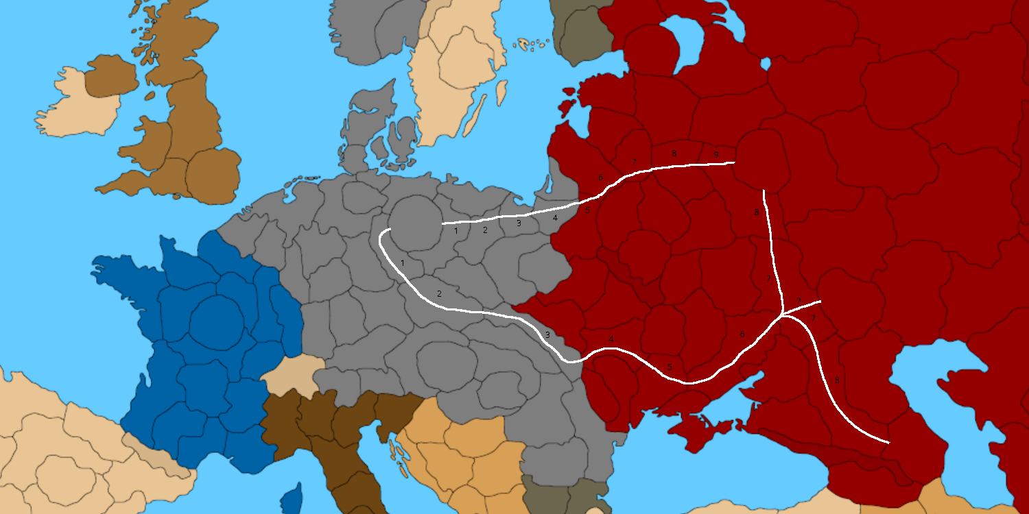
@black_elk Really, to have a good consistency with real distances, the map would need a general redrawing, as you would need sistematically to follow the principle that, the more to the north the zones are, the wider on average they should be.
However, a minimum of consistency can be injected in the current drawing for the quadrangle Berlin - Moscow - Stalingrad - Baku by a combination of border removals and additions.
In this image, the border removals are in red and the additions in black. I've also added some corrections just to have a cogent representation of both Bessarabia and the Transnistria territory which the Roumanians gained during the war.
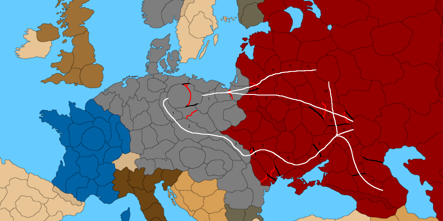
After the changes, there are the following minimum distances, to move between the listed couples of territories.
Berlin - Moscow = 7 (real 1609 km)
Berlin - Stalingrad = 8 (real 2218 km)
Berlin - Baku = 10 (real 3058 km but actually 3072 km if not cutting through the Sea of Azov)As you can see, still not very good for planning a road trip, but at least it is loosely consistent with realities.
I also think the border of Crimea should be in the isthmus, but I understand this would leave little space for units placement unless you make Crimea into a circle or anyway bigger.
Italy should be certainly redrawn pretty much almost completely. The current drawing is very bad for WW2. Other than what I said before for the northern and north-eastern frontiers, I suggest splitting the peninsula (that is all mainland Italy except the Po valley and the Alps) into two parts, with the two land-to-land borders representing the Gothic and Gustav lines. Alternatively, it can be split into three parts, showing also the Transimene Line.
Regarding the part of Tyrol (which Italy annexed from Austria as a consequence of WW1 and renamed into the two Italian regions of Trentino and Alto Adige), the map may be sufficiently parcelled to be shown as a territory (but I'm not sure it is). Else, you may draw the border somewhere in the middle of it ("vaguely halfway between the two periods", as you said) (like following the current border between the Italian regions of Trentino and Alto Adige but cutting Bolzano, which would be about the border between the prince-bishopric of Trento and the county of Tyrol during the High Middle Ages), so that it doesn't look too bad in either World War scenario.
-
@cernel Looks great! That's what we'll do!
I mean once we know vaguely where stuff is supposed to end up with the divisions and such, I can pull up regional maps and starting dialing the contours so it looks good. We can do sensible labelling at that point, for people to know what they're dealing with, or what to change if they wanted a different timeline. When I do the Russia stuff, we'll fix up Crimea, and do the Slovakia and Bulgaria and Romania stuff too. I think we should prob prioritize WW2 as the basis there, though we might tweak a few things to keep a WW1 option on the table without too much erasing or disbelief, I think WW2 will be a more useful reference point though, since that's how the rest is shaping up.
Yeah I agree on Italy for sure. I think we should redraw it entirely. I think it was probably a leftover relic from the very designs that just never got polished lol. I like your ideas for the divisions, let's do that! I'll sit on it for a couple days, in case we get a few more draft ideas on the divisions. Then we'll go to town next week. It already looks a lot better to me at the quick glance then when I started, so this feedback is rad! Thanks man
ps. How do you feel about the region around Georgia/Dagestan? Hepps added in that mountain range, and I kinda like how it works for a road block. I feel like the whole Caucasus/Middle east could use a bit of a rework too down there, since that's still very WW1-ish and kinda cartooned out for that purpose probably. The way it is right now, that'll be a major chokepoint I'd think. I wanted to settle on the regional contours first, but I think Armenia/Syria/Iran/Iraq could all get a bit of a refinement, and then maybe that could play into how we divide the approaches there. We don't have any SZ yet, but I kinda like the idea of making the Black Sea/Caspian a bit more engaging somehow.
-
@black_elk I Dig it ! Rock On !

-
Here I had an hour free, so I blocked in Cernel's suggestions for those Soviet tiles, just so we could get it roughed out. I'll do the Italy and Balkans stuff tomorrow.
https://www.dropbox.com/s/3cpi8ksdcnohpgt/TripleA_4k_baseline_oceans_repainted.png?dl=0

-
@black_elk said in Proposed Map: Domination 1941:
ps. How do you feel about the region around Georgia/Dagestan? Hepps added in that mountain range, and I kinda like how it works for a road block. I feel like the whole Caucasus/Middle east could use a bit of a rework too down there, since that's still very WW1-ish and kinda cartooned out for that purpose probably. The way it is right now, that'll be a major chokepoint I'd think. I wanted to settle on the regional contours first, but I think Armenia/Syria/Iran/Iraq could all get a bit of a refinement, and then maybe that could play into how we divide the approaches there. We don't have any SZ yet, but I kinda like the idea of making the Black Sea/Caspian a bit more engaging somehow.
Well, the relative position of Georgia and Azerbaijan are clearly highly distorted, as Azerbaijan is realistically south-east of Georgia, whereas here it is north-east of it. I assume Georgia is actually representing Georgia and Armenia together (plus the Azerbaijan exclave to the south-west of Armenia). I suppose this map is sufficiently detailed rather to show Georgia, Armenia and Sovietic Azerbaijan as different territories. About that, also Dagestan (comprising Chechenya , I suppose) and Kalmykia can be drawn as separate territories, and I actually incidentally realized about that already in my previous split proposals. Anyway, the position of Azerbaijan relatively to Georgia is really not a problem and can remain as it is.
Much less acceptable, however, is the fact that the Caucasus mountains are touching Azerbaijan to the south-west of it. This makes blatantly no sense because (in reality) they actually delimit Azerbaijan on the north (beside a small piece of Azerbaijan which is in Europe). This means that the Caucasus mountains are largely misplaced and make little sense in general.
However, the impassables in this map (in general) are quite clearly far from realistic, as one can see from the mere existence of the Ural mountains (which are rather small mountains and much less of an obstacle than many other mountains like the Alps (and I'm not suggesting to add the Alps)).
Like, the fact that there is some sort of impassable barrier between almost the entire border between Mongolia and the Sovietic Union makes really no sense, but really almost all impassables I see make no sense. I'm sure they have been added merely to make the board more interesting to play on, with little concern to realism, so this is a map-making choice.
All this said, if the Caucasus mountains would be drawn in the right place, I can tell you that there are three main ways to move through them: through the coastline to the west of the Caucasus (where there are simply no mountains because they don't reach the Kerch strait), through the Darial Gorge and through Derbent (that is simply skirting the Caspian sea).
https://en.wikipedia.org/wiki/Darial_GorgeGenerally speaking, mountains have so many passes that you really need a much more detailed map than this one for them to make sense as impassables anywhere but maybe a very few cases unless you use them better to define crossed borders. By crossed borders I mean those borders that have a single point shared between two zones, like Central United States, Southeast Mexico, Mexico, Western United States in Global 1940 or a so-called "quadripoint" in real life.
https://en.wikipedia.org/wiki/Four_Corners_Monument -
@cernel Yeah I kinda had the same thoughts a few times hehe
The whole dilemma with this section at the center of the board, as opposed to the other regions/continents, is that you get all these weird North/South/East/West dismorphs. Basically it comes from englarging the surrounding SZ areas in most cases. I think it may be possible to upscale the Black Sea slightly (I already made it pretty large hehe) but then all of a sudden somewhere else will feel visually squished or just so off. I'd say the majority of compression is happening right there on the board. I trying to redraw Kazakhstan now would be a bit of a pain, cause of where everything else it now located, and so you almost need weird abstractions. I think that's also why Hepps prob added a few more blobs in various locations. The mountains in place, I left in place, but stuff added to the north is basically to stitch in what was missing over an inset. So I don't know. I kinda agree on the mountains.
On the other hand having sorta more random impassible just as visual/geometric type features is helpful. Ways to block a path, that aren't just "the Sahara" or whatever heheh. I kinda liked that concept, but it's definitely abstract. You know, like Elephants over the alps, there's probably a way no matter where it is. Upside I guess is that they could always be easily erased to flag back to more political boundaries, but I didn't see a strong reason to start erasing yet. Eventually I'd like to get something Kurt says is like "yep" that'll do, and then I'll save it out svg, then go back and carve it up into Global, or maybe make some alts for those older games, but I like the idea of it living as a game too. I think Domination has a nice ring to it, but really you kinda need two versions of the baseline, one that takes you up to WW2 and after, and another to maybe cover stuff more pre-20th century to WW1 interwar. The suggestion you raised about distance to Moscow vs Baku or the earlier point about distance from the German line to Paris via Belgium, is interesting. The only advantage to much smaller discrete tiles is starting ownership of TTs at a given date, but otherwise it's like yeah, do we really need danzig? I mean of course we need the Album, but I mean the tiny TT. Stuff like that, I don't know, if it's small enough it's easy to draw back in though. So yeah, sorta makes sense to default more to a distance "movement in turns" frame for some of this stuff. I think it probably makes sense to do a topo morph pretty soon for the mountains. Just to reshape if it makes sense. I tried to wing it, but I'd like to go back in and do something clean. Obviously you can't get an exact morph the exact way everything has been stretched, but you don't really need to. Like WOPR did for that v3, you can just isolate all the land (white) erase it to transparency, but keep the black and the blue solid. Then lay that over a roughly stretched topo morph and sorta push/pull till you get a relief that looks pretty decent that way if somewhat inexact for everything, but it still gives a good visual impression. You know with the units and decorative elements hidden, but I just mean like the visual sweep of the topo there. Kinda subtle and more backgrounded I guess, without the large flag transparencies or graphics stuff (that should be on a separate layer in the vector like the Dog suggested). But I'd like to achieve something like that, but at 16000 and for the Domination projection and that I could then make into the Global 1940 divisions or Classic or whatever.
-
Ok so here's a quick pass on Italy and the Balkans. Obviously some stuff is a little weird from the general warp, but I tried to block it in a bit closer to WW2. For Italy there's a bit of a dilemma between deciding how carved up to make it. I like the general division along the defensive lines mentioned, since they aren't too far off from regional/river boundaries, in case of using a reference for other eras. But like further south, I wasn't sure if we wanted a few spots for Allied landings, to give it the Sicily invasion to Salerno type flavor? I guess with some SZ divisions you could probably dial that a bit more. But whatever, just trying to get a block in going hehe.
If you wanted to the Po line to split that Venetia TT more horizontally I guess we could do that, but it gets a little weird. Dividing Italy entirely by German defensive lines later in the war probably wouldn't be terribly helpful for maps in any other era, cause it's like a very specific point of reference there, as opposed to drawing provinces, but I guess this is a WW2 board now right lol. Anyhow, I'll let someone take a red marker to it, before I put in too much more work. It's kinda exhausting lol.

-
@black_elk I wouldn't split Sicily into two or more territories on this scale, the same for the already relatively small Albania. Similarly, maybe it would be better merging your Calabria and Apulia territories, merely on the consideration that they are now relatively quite small (so they have a dart of space for units placement). Also, the Bulgar Macedonia is too small a territory. About this, maybe I've been misunderstood: since here Jugoslavia is given as neutral, Albania and Bulgaria should not touch each other because that happened only after Jugoslavia was carved up. You may want to draw the internal boundaries of Jugoslavia as to represent such carving, however.
The Gothic line I guess is acceptable, even though it is drawn much more to the north of where it should be. If it is a problem of space, I'd say there's no need to show the Transimene line (so the two territories divided by the Transimene line may be merged).
I suppose you forgot to give Italy the Dodecanese.
-
@cernel Yeah I guess it really does depend on whether you want 40 or 41. The Balkans is such a headache heheh. OK so fewer divisions in Italy then.
I mean on some level, it's like you could just start slapping down random nodes and curves or something. Rather than having me draw it out for each iteration. I'm trying to think of a more expedient design for drafting.
Obviously this would be somewhat simpler if we used a standard projection of any kind, but the downside there is the map would just be too damn big I think hehe. You'd be just scrolling forever. So I guess this is bound to be a compromise. I mean I can just break out the "<insert start date month/year>" for the rough political boundaries on a separate layer or something. But seems like what we need is kinda like Hex blob for the tiles, with smaller zones that are likely to be erased at a more midscale game. The paint job I did was not really a suggested start date or TT possessions, I just wanted to show the world colored in, cause otherwise it's easy to tune stuff out. So I used a vaguely global 1940 paint up lol. Kurt said 1941 though.
Good call! Yeah I'm sure I just missed with the paint bucket, so many tiny blobs heheh
-
BTW Tibet was independent. Japan controlled all Kuril islands but North Sakhalin was belong to the Soviets. I see Mozambique is divided. Also it is better to give Burma to the Raj.
With there are so many Allies nations. Is one piece Japan really the best option for gameplay? I doubt. For example WaW would be really broken if Japan was unified. One piece Japan might be unstopable in this scenario. Plus it would probably force the US investing only European fronts. I would like to learn the opinions of the community.
Also what about the Soviet-Japanese war? Should they really at war with each other?
-
@schulz Good eye! hehe I guess I should probably repaint it more 41-ish in some other spots too. Just so I don't forget where we're supposed to be headed with this stuff, or keep missing the same spots with the paint bucket lol. This is like halfway there-ish I guess. Not sure how one wants to assign control in the Balkans, whether all to G, or some kind mini faction, or like who annexed/occupied what and when hehe, but anyway, did a few colors to get a better feel there. More shades then we need, but just to give a quick pass. I'll wait till we got a start date before finishing that out.
Not sure on the Japan Q. To me it would depend on the forces I guess and the SZ design. For NAP with the Soviets, I kinda like total war conditions there, but it's always problematic. I've never found a great solution that hums for me. I think it would be nice if Russia could defend itself at least though, just so it doesn't go too Classic up there lol. On the other hand, towards the endgame I kind of enjoy if Japan can mix it up. So again, hard call. I think the focus for the IJA should be in China though. I mean that tied down what, like a million dudes? There should be incentives not to galivant up north as Japan on account of that, provided China doesn't just get flattened immediately like in all the official A&A boards heheh.
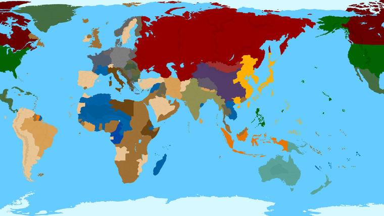
Oh also, while thinking about the start date, I think it's possible (depending on the turn order sequence) to cram a fair amount into the first round. Like if you wanted Europe to feel more early 41 and the Pacific to feel more late 41, I think that's doable, provided Japan and the US go at the very end of the sequence. Like if you wanted to design a more Barbarossa thing over here, but a Pearl Harbor vibe over there, just make sure the turn order sequence feels kinda right for that I'd say.
In 41, Italy doesn't have much presence in East Africa, if any, so the scramble there would need to get fixed. I showed roughly where Free France would start, if all the rest of the Blue was Vichy (to Germany in Africa/Med and Japan in Indochina). I think we could still keep a bluish kinda tint to it maybe, like in the reliefs, to get that point across, but easier to just assign control to G, so they're more dynamic. If the Blue was starting G ownership, it would allow the British and Americans more zone to expand. I'd do the same in France, like everywhere until Paris is liberated. Control of spaces outside the main core Capital zones should probably be starting owner Attackable Neutral, which would solve a lot of issues with the regular A&A games and liberation weirdness. In other words when Torch goes down, or D-Day, those TTs in N. Africa or Normandy should go to control of the conquering power, rather than returned Free France. Better for the gameplay once the Allies cross the Atlantic I'd think.
For total number of player-nations/factions, I don't think we need a crazy gang of factions overall, such that the sequence takes forever, but I think another smaller Axis faction for parity with the Allies could potentially be fun Again the turn order sequence is pretty important to make that work/feel right though. Basically to avoid a bunch of can opening nonsense. I did the colors more for style than a suggested number of factions here.
-
Yes. Japan having a very easy time to steamroll China and Asian Russia is very big problem for a WWII scenario. It is really need to be addressed.
-
@schulz It is very easy to address, actually. Under any realistic representation of production values, Japan is going to be so weak that can be handily crushed by using only a quarter of the United States power against it. The only way Japan can do anything like you describe is if you are making a map in which it has a production riduculously above any historical values of any kind.
Both Japan and Italy were not the first world countries they are today. Today Japan is the third richest country in the world (about a quarter the GDP of the United States) and Italy has a higher GDP than Russia. Back in WW2, they were backward and scarcely industrialized countries. Both Japan and Italy had about the same productivity per person, but Japan was stronger because of having more persons in Japan and a more valuable empire. In either country, most of the population was still living almost like in the Middle Ages.
-
@cernel If Japan and Italy is going to be weakened, wouldn't Germany need to be unrealistically super strong in order to have a relatively balanced game? With realistic production values, probably the Soviet Union would be designed to doomed to fall.
There is actually another method. Make China impassable and no Japanese-Soviet war. No war with China and the Soviet Union means Japan can afford to have less production values.
-
So earlier I mentioned that is relatively easy to add circles back in, once we know what's what.
Here's a rough example of how that might present, using circles at 250 for the Capital spots.
As always, it looks a bit weird doing that for Italy for some reason, although at 250 the circle just about lands where the Lines would be hehe. I slapped some fast flags down real quick just for flavor.
I'm not opposed to the circles in principle. I just think if using them, then there needs to be some kind of rough parity around the map, so it doesn't look oddball only having them in a very few places. Another option would be to do some beefy circles like this for capitals but a few smaller circles elsewhere for other key spots that make sense. Not sure what look people prefer, but just for a quickie thought I'd throw something together. I think this looks alright myself, but I don't know what others would dig lol
https://www.dropbox.com/s/0zrfcz78w7ucqi7/TripleA_4k_flags_with_circles.png?dl=0


Hello! It looks like you're interested in this conversation, but you don't have an account yet.
Getting fed up of having to scroll through the same posts each visit? When you register for an account, you'll always come back to exactly where you were before, and choose to be notified of new replies (either via email, or push notification). You'll also be able to save bookmarks and upvote posts to show your appreciation to other community members.
With your input, this post could be even better 💗
Register Login