Proposed Map: Domination 1941
-
@cernel I don't remember where did I get the information. Germany taking Moscow probably wouldn't enough to convice the Japanese to invade the Soviets. After all China didn't collapse after losing its capital (Nanking).
-
@cernel said in Proposed Map: Domination 1941:
@unternehmer Not a bad idea, but I'm not seeing how you would do this nicely but by using an equal-area projection. You should be aware that, in doing so, Europe will be a very small part of the map. For example, you will have almost as many territories in Brazil or Australia as in the entire Europe.
The area of Europe (with European Russia) is 10.18 million square km, Brazil is 8.5 million square km and Australia is 7.6 million square km. Once you take out the irrelevant Komi and Nenets republics in the north of European Russia, Europe will be about as big as Brazil or Australia.
Still, this is not an actual board-game, so it is not bad having most of the map being virtually useless (because it is not actually taking space).
I understand you are not asking to apply this method everywhere, but, if you don't while using an equal-area projection, the alternative would be having bigger territories in non-key areas (like many maps already do, but even more extremely so than, say, WAW).Dear @cernel,
what for does any TripleA map need territories of Latin America, Africa, Middle East, Central Asia and Siberia?AI has always difficulty to transport anything around Latin America via Cape Horn and around Africa via Cape Town. AI has always difficulty to take regions far from its own capital or far from capitals of its enemies.
Important are Europe, Mediterranean, Suez, West and South-West China, Japan, South-East Pacific and maybe briefly North America (West Coast, East Coast, Panama) and North Australia.
My idea is to concentrate on key areas + some simplified land way between West Coast and East Coast + simplified naval way between Atlantic and Indian Ocean.
So something more like Empire Total War concept (mentioned above by @Black_Elk) than global but not used by the AI. -
@cernel Yeah, exactly!
So I was banging away with the eraser and paintbucket, skipping around. Nearly removed those long squiggly tiles like the others, but then decided to leave them until we get to the point of refining central Asia. The color was probably a paintbucket miss lol. Divide in 3 or 4, assign control to Mongolia, and then you have something there that looks more G40-esque. I think the Gobi is the same situation, and the Himalayas. It was hard and fast, I was doing this at like 3 am lol.
Basically what I need to know is exactly what you are asking, from Kurt - how many tiles are desired and at what general size for a given region, and what is the start date? Because I'm not yet at the point of refining Central Asia and can't really do that until I know, so I just let it ride in the meantime. I guess after a few more days I'll just starting making the shot calls. In one respect, it would be simpler for me to not show anything until it was all done (drawing with the someone look over the shoulder and all) but then I wanted this to be more collaborative. So instead of just being 'my map', it would feel more like 'our map.' Plus it's just more efficient too I think in some ways. I mean efficient in terms of prodding me along after hours heheh. Like I'm more motivated after someone says, "hey wait, that's weird! that's in the wrong place!" - "wrong connection there. or wrong color." It's spurs me along and makes me want to keep going with it. Hence the many draft postings.
The color choices aren't factional, I was trying to just show what changed, so I used similar hue's but with a different shade/tint. That way someone could tell me, 'OK erase here, collapse there, change ownership here.'
The reason I left some in place is so when I go back later to do Global at 1940 start date, all I'll have to do is erase rather than draw too many lines, if that makes sense. Provided I can make this one look clean.
What I was hoping to show, is that, once I know the TT divisions, I can reshape the TTs so they look more accurate to the regions or provinces to which they correspond, basically like I just did for France. Now that you can see it, you can say "hmmmm, ok if that's that, then we should do this for the Germany TT divisions." Or trying to do the same for Italy depending on how many tiles one wants. Once we see how large the surrounding tiles are going to be, I can shape the current so that it will look more 'realistic' in the morphology.
Just as an example, if you want say Normandy and Brittany and Pays de la Loire to be a single tile, I can just erase stuff to make it work quickly. Or if someone wants to divide something, I can try to follow a provincial shape, or a river, and draw the border that way or just reshape the tile. The morphology is not equal area or standard projection on this map, so instead what I am doing is actually drawing out contours based on the proposed divisions. With minute rescaling and a bit of verve, in recasting the shapes, so they become less like blobby blobs and more like the real deal, in the basic loo/shape, but according to same general warp that the broader regions are undergoing.
Or take Mongolia as an example in Asia, since you mentioned, cause in Global we know its all blobby and divided into a bunch of tiles there, right. It's also further North in G40 cause of the way China is cartooned in that game, so that's going on too. But what I can do, if one wanted to make G40 out of this baseline, is carve back and reshape those longer rando Mongolian squiggles, which are vestiges of Hepp's mountain designs, so that the block in is more G40 lookin' there, for Mongolia.
What I'd like to do is find some compromise lines, so it's easier to switch from say 1940 to 1941, or possible switching from either of those to something more 1914 if possible, without having to redraw a ton.
There are really only 2 impassible zones that show in the midscale official A&A boards. The Sahara and the Himalayas. Those are the only terrain-y impassible tiles on those boards. Everything else is like a political impassible (say Turkey or Spain or Arabia), so basically the changes are just what color to paint bucket hehe. But when it comes to all the other TTs I think they should be reshaped once I know how many breaks are desired.
The same thing with Yugoslavia or anywhere that looks weird there, as if halfway between two start dates right now. Once I know how many divisions are desired, then I can reshape stuff so it looks somewhat more accurate, rather than just a randomly blocking-in arbitrary lines, which is how I've been banging it out for speed. For the different color shades, I just tried to show who moved where between the 1940 display and the 41. But we don't want a bunch of tiny ass spots right, not in the actual game map anyway, although for a draft baseline it seemed helpful to leave some smaller divisions for now. Just so we could say "yeah erase that, cause we want it look like April 1941, not March!" or whatever heheh. Or in some cases, to just kinda fudge the lines so they fall somewhere between the current lines displayed and the desired final maps.
The fact that I painted it up this early and have posted the working draft is probably adding to some confusion here, but I just wanted to make it easier to see what's been drawn and to give an impression. Just so it's easier for Kurt or you or whoever to say what makes the most sense and what doesn't. I'm taking all your suggestions to heart and jotting notations, but since this isn't my paying job, I'm just trying to bang it out after hours, and a bit haphazardly lol.
I think we're making progress though right? I mean it already looks better to me than what we had going a week ago. So if we give it another week, maybe we'll actually have the baseline set and can start busting into the utilities haha
here I only have like 15 minutes before I gotta take the dogs to the Vet, but just quickly to show how we can do the sorts of things you mentioned about distance from Manchu to Moscow, and it's pretty fast. Obviously we can redraw the Hepps mountain squiggles there, but again just for an impression. I wish I was fast enough to do the whole map totally dialed in one night, but I'm just not that fast hahah
@Unternehmer Yeah, it would be really cool if tripleA could somehow load 2 maps at once, so we could create an effect by Theater (basically exactly like Empire Total War, just with say 5 or 6 regions instead of 3.) But sadly tripleA can only load one map at once, so we are forced to compromise. Basically, like I showed on the first page, we are kinda morphing enlarged regional insets so that they can just stitch together in a single world view, but to have that look slightly less distorted overall than say Revised/Global/HBG official boards. I tend to agree with Cernel that the reality and principles outcomes of the war were still fairly Euro-centric and that official A&A gameboards wildly exaggerate the Pacific and Japan's capabilities. But people seem to want to see the whole world, not just the Theater. I don't know that anyone even plays Europe 1940 or Pacific 1940, they play Global 1940. I'm the same myself, I'd rather see the whole world, even if it's a bit weirdly shaped haha. Still, that said, I think we can get closer. Meaning the world doesn't have to look quite as cartoonish as Official G40, when it can look a bit more like this. Giving us something somewhat cleaner/recognizable in the distortion, but while obviously still being distorted. I tried insets in other games. Great War was the most ridiculous for that, but I'm never terribly happy with how that looks. It seemed simpler to draw out the whole world, which is what led to Domination. Surtur and I had just finished GW and wanted to attempt something new there, but never had a clear idea of what to do with it. I think for WW2 the ideas are much clearer, so I'm actually excited about it again hahah.
Anyhow, I'm a little under the weather today, so I'm going to shelve it for a day or two. I'd like to get Germany/Italy/Balkans dialed in Europe, before focusing on Asia/Pacific. I'll wait to see if people have ideas for divisions. If not I'm just going to start blocking in TTs in Europe and adjusting the shapes of German provinces to accord with the divisions already discussed. So the can look more like the corresponding regional provinces, once redrawn at the desired blob size. That's the aim at any rate.
Oh damn, gotta jet and throw the hounds in the car. I'll stop back by later tonight though and see if we got some more ideas to keep fixing it and making it better. Catch ya in a few!
-
Doc says the dogs are both in good health!!! So I'm in a great mood now! haha
I'll dive back in later tonight and try to start dialing stuff a little bit more.
Right now the baseline for this Domination 1941 map is literally twice as large at 16000 px, as the baseline was for Power of Politics 1914 (which was just under 8000 px wide.) The original Domination was only 7500 px wide.
I'm feeling like we can definitely accomplish a lot more now, and the Domination 1941 map is bound to be way less crowded than say NML, so that's good. But I still feel like some of those TTs in Europe are a bit tight even with the upscale. Some need to be collapsed into adjacent tiles I would think. Or redrawn to be more beefy. I mean right?
Who knows, maybe Hepps will come back at some point and want to re-use this new one for an upscale? I mean since it's got the 1 pixel lines, but at twice the scale for the World. Not sure there, but just in case I tried to preserve his work in the initial pass. Now that we've moved beyond it though, and clearly into the WW2 planning, I'd like to really delve in and start house cleaning.
Compared to the current Global map, this one is much larger, by like at least 33%. So we could conceivably take the standard default unit sizes for a game like Global up from 48 px or 54 px to something more like 75 px or even 100 px in those games. Do a new unit set that has quite a bit more detail and polish than we've been able to achieve thus far for the standard games. For something like V3, you could do truly massive units, and then when you scale back down to the actual play view (at say 50% or 25%), everything would look way cleaner. Or of course you could just use the regular units we have at 48/54, in which case we could fit many more unit's in a given G40 tiles, before we get spillover. Either way, we're in a much better position with the upscale.
Using this world projection to make a map for G40 will take much less time than trying to figure out all the TT deets for Domination 1941, so I'm starting with the harder nuts first, to get them cracked, because in know making it fit G40 or V3 will be way simpler once that's all done hehe.
For a general gameplan, I want to get Europe looking aces for 1941 and then move East from there to do the same in Central Asia and the Middle East, since they both need a lot of work.
-
@black_elk said in Proposed Map: Domination 1941:
Doc says the dogs are both in good health!!!
 :flexed_biceps:
-
@beelee Thanks man!
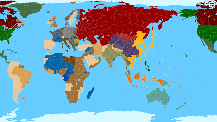
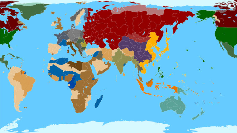
Ok this might help... It includes the divisions of the Global 1940 game, approximated to this projection. We can clean those up a bit, but least it gives us a way to visualize.
https://www.dropbox.com/s/yp6ulpzggsvnphw/TripleA_4k_baseline_G40_example.png?dl=0
Obviously there is some weirdness on the official game board, trying to get all the labelling and such to match the geographical reality can be a bit tricky at times, especially where the Pacific and Europe boards meet. China is pretty weird on the official boards for example, but I tried to strike a compromise for the boundaries that would kinda reflect both, for familiarity. I can still refine it, of course, but I think this works for a rough example of the blocking. Perhaps it's easier to think of stuff in that frame, like what should be further subdivided and such, once we can kinda see what regular global would look like.
This is sort of what I'm aiming for though, when I said I wanted it harmonize with Global somehow hehe.
Basically the White lines above show the standard Boardgame divisions and the black lines show the subdivisions we've been kicking around.
Also here is a Global 1940 baseline at 16000 indexed up, with only G40 boundaries... in case anyone wants to play around with it, or start adding the sea zones and such, so we can try running it through utilities hehe. It just needs a crop probably in the Antarctic, or an ice sheet extension up north to make sure Siberia and such works as intended. I was gunning pretty hard and fast tonight, so might want to give it a double check lol.
https://www.dropbox.com/s/2dayaogn6jhtg5y/TripleA_4k_Global_1940_baseline.png?dl=0
Best Elk
ps. for starters I would like to rework Poland, try to lift Romania and Bessarabia a bit. Larry had a kind of weird extension of Poland going on in G40, and Hepps also used some distortion in that region for WW1. But I think think we should maybe round it out a bit, so it doesn't look quite so stretched. Belo is always a pain in the ass, the way Larry had it connecting to Arch and such lol. But I think that could be dialed a bit now that we have a more realistic looking globe. Russia is always problematic. I think the best solution is probably to shift all the lines a bit to the right, just so they don't have to stretch quite some much to land their connections. Not as extreme as the Classic board of course, but Moscow could probably shift slightly to the right, and it would make all the surrounding TT shapes a little more recognizable probably. Not sure what's best, but I just wanted to block em so we could start thinking about it. But yeah, Poland needs some love. Since France was stretched, I think it makes sense to enlarge Poland, and perhaps lift Scandinavia to get a little more room in the Baltic SZ and the Baltic State. Like basically just lifting everything slightly, and then rounding it out to the right, in the ballpark. If that seems good to you guys? I'll try to refine it some more the next time I got a night free.
pps. Tibet is a little weird too. My theory is that Larry could not get a Map board printed in China that showed Tibet, so instead he just clipped the world by like 3 inches lol. What would the Beastie Boys say?! So I'm not sure what our best solution would be there. Essentially the Official board is drawn in such a way that makes that part of the map kinda wonky. I tried to land somewhere in between, but not sure if it vibes for you guys?
Catch ya next round!
-
And there was me thinking how hard can it be to trace a map of earth foe WW2, answer very difficult.
@Black_Elk You will not please all the people, as so many compromises have to be made, so I appreciate your reworkings!
-
@thedog For sure!
Yeah it's a trip. Basically what we're battling against is a kind of cartographic uncanny valley lol.
The more realistic the contours become, and the more recognizable the shapes (political map of Europe/the World, being very familiar to many people at a glance) the more one notices weird flaws. It's hard to describe how much stretch vs compression is happening, but it's pretty significant. Fortunately you can disguise that to a fair degree, provided you get the relative shapes into a rough balance. You'll note that everywhere in the Soviet Union has this sort of horizontal tendril thing going on right now. That's because of the way Larry labelled stuff. You know, by calling a TT Smolensk, and then it's like well how far does it have to stretch so that Smolensk will actually be inside that TT, rather than outside of it, while still connecting to some other named spot that's probably pretty far away heheh. At some point you kinda have to shift, but that's already happening even now, before the rewarp, so you don't want to push it too far. Otherwise all the sudden Moscow is further east than Baku, and like Cernel mentioned that feels super weird when stuff like that occurs. It only works in Classic/Revised because the map is so cartoonish and misshapen that you hold it to a lower standard. Here the world looks more like the world so we want it to maintain that illusion a bit more.
What I will likely end up doing is just redrawing all the Global 1940 tiles in the USSR and Eastern Europe until they don't bug me quite so much anymore. Then I'll return to the subdivisions afterwards, once I got something I like for those larger G40 divisions. Just seems more efficient at this point.
I do kind of enjoy the way that having smaller regions displayed kinda reinforces the larger divisions though. Like I think it just looks cool as a visual. I don't see why we couldn't leave those in place, even in the G40 map, just maybe knocked back in shade or opacity. Like they could still display to give that extra flavor even if it's purely decorative in the regular G40 game. But then when you load up Domination, all those decorative interior divisions become real divisions (actual new TTs). So that'd be like a way to lead the player naturally from one game into the next. You know, so they have a touchstone there for familiarity. Plus I just think it looks cool heheh
It takes a while, but I don't mind the noodling. I used to draw stuff like this with graphite, so I'm pretty used to it haha. I drew this one the very same year that TripleA came out I think - almost 20 years ago! lol Crazy
-
@black_elk I just had a flashback looking at that lol
I'm back in 2022 now though
")
Edit
That should be on a Acid Rock Album Cover lol I guess they don't do albums anymore.I gotta quit looking at it. i get lost and each time is harder to get back lol
-
@cernel Here is my not quite complete list of maps https://axisandallies.fandom.com/wiki/Category:TripleA_Maps.
TerraFirma is currently the largest playable map. It has some interesting ideas, but needs a lot of work to make it a good game.
-
@rogercooper said in Proposed Map: Domination 1941:
@cernel Here is my not quite complete list of maps https://axisandallies.fandom.com/wiki/Category:TripleA_Maps.
TerraFirma is currently the largest playable map. It has some interesting ideas, but needs a lot of work to make it a good game.
Great table! How have you collected all that data? Have you actually opened every single XML file and counted land and sea zones separately?
By the way, as I said, I believe you can correct two things in that list regarding Terra Firma.
- The zones are 1515, not 1155 (which is what your table says).
- Despite the fact that the folder name is "TerraFirma1939", the map is certainly not set in 1939. Albeit the fact that Albania is Italian implies a 1939 or later date (but I assume this is merely a mistake like the British Rhodes), the much more important fact that all of Czechoslovakia is not German implies a 1938 or before starting date and the Chinese ownerships imply a 1937 or before starting date. Also on the account that Ethiopia is fully Italian controlled, I'd say I'm almost sure this is a 1937 game.
Why a 1937 game has a folder called "TerraFirma1939"? Maybe it was initially intended to be 1939 and the map-maker never corrected the name of the folder.
-
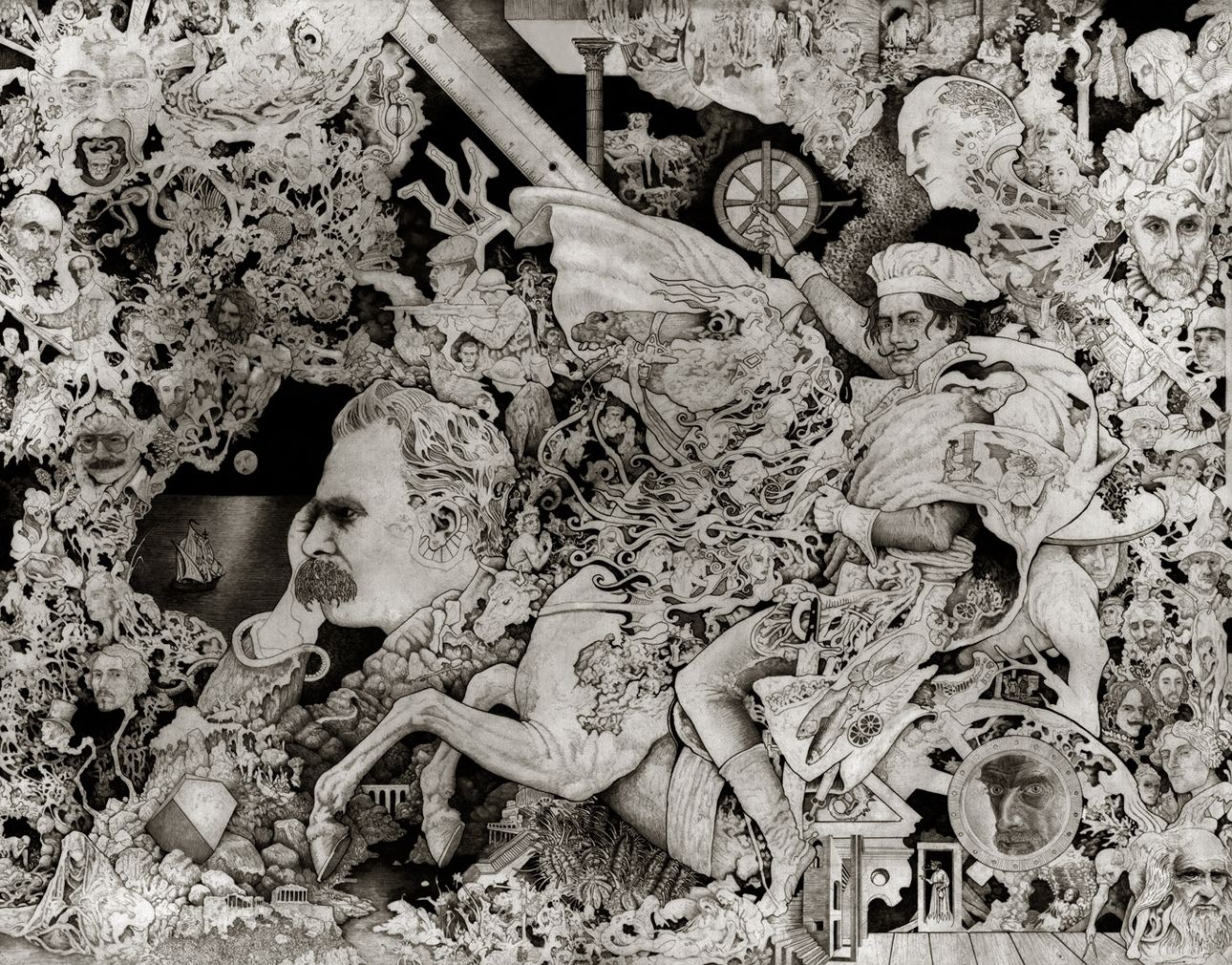
Wow I'm having a hard time coming down from this. Super Impressive
-
@Black_Elk
Is the dude riding the horse with a chefs hat, you? :winking_face_with_tongue: -
@thedog said in Proposed Map: Domination 1941:
@Black_Elk
Is the dude riding the horse with a chefs hat, you? :winking_face_with_tongue:ha hah good one ! I thought it was napolean or davinci lol :grinning_face_with_sweat: :grinning_face_with_sweat: :grinning_face_with_sweat:
-
@beelee heheh it's Salvador Dali, riding David's Nightmare (from the famous painting of Napoleon). He's wearing the chefs hat, cause of that opening line in his memoir "The Secret Life" : "At age 6 I wanted to be a chef. At age 7 I wanted to be Napoleon!" hehe. Every face is master, they're all painters and draftsman, except for Nietzsche lol. I was pretty young, so it's a little sophomoric, but I still think it might be the best thing I ever drew hahah
OK so I just ponied up and posted my draft map design at A&A org...
https://www.axisandallies.org/forums/topic/39386/working-on-a-new-map-1940-41
I figure the gang there will probably hammer me with little to no mercy -on all the various points of accuracy and historical realism - so it seemed like a good stage for that, and to gather some constructive criticism.
I was a little reluctant to show it in this half complete state, since it's a WIP, but on the other hand, it's easier to fix stuff now, than if I wait until it's all totally dialed only to find out I goofed something major.
Fingers crossed! Hopefully they don't hate it with a burning passion lol. We'll see what they say, and then I'll bang it out next week, after it's had a few days to marinate. We'll gather sufficient critiques to move forward into the home stretch and then just dive headlong towards the finish line lol.
Best
Elk -
@cernel said in Proposed Map: Domination 1941:
@rogercooper said in Proposed Map: Domination 1941:
@cernel Here is my not quite complete list of maps https://axisandallies.fandom.com/wiki/Category:TripleA_Maps.
TerraFirma is currently the largest playable map. It has some interesting ideas, but needs a lot of work to make it a good game.
Great table! How have you collected all that data? Have you actually opened every single XML file and counted land and sea zones separately?
By the way, as I said, I believe you can correct two things in that list regarding Terra Firma.
- The zones are 1515, not 1155 (which is what your table says).
- Despite the fact that the folder name is "TerraFirma1939", the map is certainly not set in 1939. Albeit the fact that Albania is Italian implies a 1939 or later date (but I assume this is merely a mistake like the British Rhodes), the much more important fact that all of Czechoslovakia is not German implies a 1938 or before starting date and the Chinese ownerships imply a 1937 or before starting date. Also on the account that Ethiopia is fully Italian controlled, I'd say I'm almost sure this is a 1937 game.
Why a 1937 game has a folder called "TerraFirma1939"? Maybe it was initially intended to be 1939 and the map-maker never corrected the name of the folder.
Yes, I identified each unique map, opened the XML and counted the territories. I will fix the counts on TerraFirma.
-
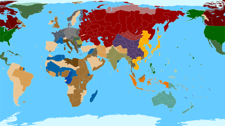
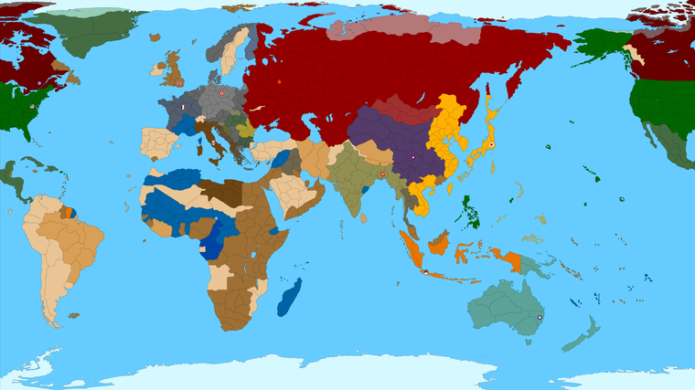
OK so I think I found a solution I like for Eastern Europe...
https://www.dropbox.com/s/yp6ulpzggsvnphw/TripleA_4k_baseline_G40_example.png?dl=0
Rather than shifting Moscow any further East, which I really didn't want to do, I instead I did a more vertical warp for this area. It runs a little counter to what's going on with Western Europe on the bend, but I think it still works.
Basically I got enough space from doing that for another dozen naval units in the Baltic SZ and a little more space for Norway, Baltic States and Leningrad too. I tried to make the area for sz 113 as large as I thought I could get away with too, before Scandinavia started looking too goofy. The space for sz 113 should be about 3 times as large as the current Global map now.
For the Belo to Arch conundrum, I got it set up so that the TT called Archangel OOB is essentially everything from Arch to include Tver and everything between, and then Belo includes the southern portion of Pskov, just to get the connection to land right. It's a little stretchy, but I think it works alright with the surrounding tiles reshaped a bit. Also shifted Romania a little was well and the pripet marshes zone, to bring it all back in relative alignment. Let me know if that works alright for you guys! hehe
Best Elk
-
@black_elk said in Proposed Map: Domination 1941:
The space for sz 113 should be about 3 times as large as the current Global map now.
:beaming_face_with_smiling_eyes: :beaming_face_with_smiling_eyes: :beaming_face_with_smiling_eyes:
-
Here is the all black lines view again for the subdivisions, with the new adjustments, just to see how it might read.
https://www.dropbox.com/s/cfbiii4lb6ql261/TripleA_4k_baseline_G40_example_flags.png?dl=0
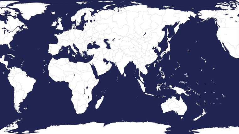
ps. And below is the 16000px map showing only the standard G40 divisions in a 3 color bitmap. Arctic ice sheet blanked back to blue there, just for the quick read, since it kinda needs to be in full color for the ice thing to look alright, in white it just makes Greenland and Canada etc look kinda funny heheh. Navy blue made that arctic line somewhat less noticeable. I'm a light blue Classic man myself, (I wish we could control the sz color preference in the mapview tab, or in the map properties to edit that as Hex like everything else, though that color choice is still kinda hardcoded into the baseline for Sea Zones I think right?) but anyhow, just for variety, thought I'd do it like that in dark blue for a sec. We'd just paintbucket back to white up there in the arctic when the time comes to run it through the utilities.
https://www.dropbox.com/s/dcrluqe7axymdm7/TripleA_4k_baseline_G40_example_navy.png?dl=0
Preview
Here's a quick vector pull
https://www.dropbox.com/s/ehcnfkr28llq8gg/TripleA_4k_G40_vector.svg?dl=0
I'll let it ride for a few nights before giving it another pass. Catch ya in a few
-
@black_elk
This might help, in Inkscape with your map loaded
File> Document Properties> Click the Resize to content: button
This will put a white paper background under your map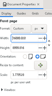
Hello! It looks like you're interested in this conversation, but you don't have an account yet.
Getting fed up of having to scroll through the same posts each visit? When you register for an account, you'll always come back to exactly where you were before, and choose to be notified of new replies (either via email, or push notification). You'll also be able to save bookmarks and upvote posts to show your appreciation to other community members.
With your input, this post could be even better 💗
Register Login