


Subcategories

  • Some questions about map's graphics

    7
    4 Votes
    7 Posts
    1k Views
    Black_ElkB
    Oh also I just remembered, so for the smallMap image you can try just making that a solid blue swatch at the desired pixels instead of using "Other: Optional Things -> Run the Image Shrinker" Just to make sure the white dots aren't coming in from that. If they only appear on the mini map it's likely from the tiny image there, where some white isn't being fully covered over by the HEX colors from the polys so they show as gaps. Unless you have tiles that are unassigned and intended to show as white on the map, the smallMap doesn't actually need any white or black, since it's just painting stuff over from the polys there. For example the smallMap in UHD global looks like this... [image: smallMap uhd global.png] Only the arctic section at the very top was left white, since those polys weren't assigned in the game (to create the little ice sheet effect), but for everything else just needs a blue field to paint in the HEX colors on top. The white there was just me lazing out and not wanting to assign a ton of extra icy tiles, but if assigned and given a HEX they'll paint like all the other tiles and you just need the blue. ' For 4:3 at 320 px, try using this for the smallMap jpeg... If the little white dots don't display anymore then you'll know they were just coming from that tiny image instead of the actual polys. [image: smallMap.jpeg] I totally forgot, but the same thing happened to me as well! lol Hope that helps! ps. oh and for the shape of the polys in the mini map display, I believe it will just stretch to match the aspect there when painting the polys into the mini if it's different than the main map. Probably not a big deal usually if the aspect is slightly off between the two rectangles when showing a squiggly world shape, although to hold a simpler overall shape like a circle, I think both need to match or the circle might get compressed and go oblong? I think you're already ahead of that one cause 4:3 is optimal for tripleA. It only sorta works at 16:9 cause the Mini and UI tab can kinda cover the unused area. I'd have done the UHD in 4:3 but the regular world war II global that bung made at 2:1 so I split the difference, but it was kinda wonky at 16:9/16:10 which I didn't manage anyway, cause ended up cropping at the margins a bit. Go figure! I'm still learning how all this stuff works myself, even after many years trying to puzzle it out haha. Best of luck dude! Let me know if you hit any snags
  • How to make a map AI friendly?

    thedog
    8
    5 Votes
    8 Posts
    5k Views
    TheDogT
    Short answer yes. Using isAI and say rounds 4-5, 8-9, 12-13 or another condition Have 2 or more turns give the AI a chance to assemble forces for the attack.
  • Flak Tower Image

    10
    1
    1 Votes
    10 Posts
    2k Views
    B
    @ebbe FlakTower is right below your "German". Coincidence ? I say Destiny [image: Screenshot from 2024-02-16 09-48-40.png]
  • Help creating a map

    27
    2 Votes
    27 Posts
    9k Views
    RogerCooperR
    You should at least double the size of your map, so the map will have space to deploy all the units.
  • SBRs: Use Multiple Dice

    21
    2 Votes
    21 Posts
    5k Views
    B
    @wc_sumpton said in SBRs: Use Multiple Dice: I bow to your superiority! heh heh lets not get carried away now
  • How to default a player to be the AI?

    7
    0 Votes
    7 Posts
    2k Views
    TheDogT
    @eqqman So the "none" can be used as a faction that does nothing, but can have; "capital" code. step logic like notifications conditions Search map xml for to look for "DoesNothing" and then the faction to find actual use.
  • How to correctly clone an existing map so you can edit it?

    3
    0 Votes
    3 Posts
    1k Views
    E
    @rogercooper Hello- I figured it out, the map.yml file had the last required edit in it.
  • How to add new units?

    11
    0 Votes
    11 Posts
    3k Views
    Bill GillinghamB
    @joseph-prince - I'm late to the party... but for anyone searching, the problem was the capitalization (as one replier did mention, but it was never tested) lightArmour vs lightarmour
  • Customizing Production Tabs

    5
    0 Votes
    5 Posts
    1k Views
    U
    @thedog Thank you! I suspect the issue is that I have spaces in the names of my units.
  • Technology Rolls, enabling other technology rolls

    8
    0 Votes
    8 Posts
    2k Views
    U
    I've settled on Age of Tribes approach. Very straight-forward.
  • Looking for map feedback!

    5
    1
    2 Votes
    5 Posts
    1k Views
    TheDogT
    @ebbe Should change your version to Version 2.1 <connection t1="East China Sea 3" t2="Kagoshima"/> is not a valid connection East China Sea 3 has Kobaya which is not possible to be in deep sea Line 1980ish Construction as a resource is missing Politics phase needs to go in each Clan phase, so when playing PvP its just one session, as Matt suggestion Using TripleA-2.6+14473 in each test game I get this below, sadly this is a first for me, so cannot offer any suggestions and I cannot make it repeat. [image: Screenshot 2023-08-18 092106.png] Searching the forum found this; https://forums.triplea-game.org/topic/1609/triplea-2-0-16244-issues-with-an-unreleased-game @Cernel Did you solve the "battle not displayed" problem?
  • Easier Map Making with Inkscape & reusable art assets

    thedog
    11
    2 Votes
    11 Posts
    4k Views
    TheDogT
    I am using a new to me Icon Editor called greenfish icon editor pro its free http://greenfishsoftware.org/gfie.php#apage [image: 937e2587-73a7-4566-aa7c-261624c4c3e3-image.png]
  • Cannot cast TriggerAttachment to RulesAttachment

    7
    1
    0 Votes
    7 Posts
    2k Views
    Jason Green-LoweJ
    @wc_sumpton said in Cannot cast TriggerAttachment to RulesAttachment: :1:false:false:false:false Eeey, there we go, that works. Thank you!
  • May move through but NOT remain on territory

    5
    0 Votes
    5 Posts
    1k Views
    C
    @ebbe I think this would be a very useful and easy to implement feature request, and I would certainly use or consider using such an option. My suggestion, is adding a territory option like <attachment name="territoryAttachment" attachTo="1" javaClass="games.strategy.triplea.attachments.TerritoryAttachment" type="territory"> <option name="isUnoccupiable" value="true"/> </attachment> The "isUnoccupiable" option has the same effects as the "isImpassable" option but allows moving through (yet not retreating into) the territory. I hope such a feature will be added.
  • 0 Votes
    3 Posts
    1k Views
    Z
    Seems it wasnt working because I had the playerattachment for the player underneath all the triggers. Ty for confirming it works, it made me think of trying that.
  • End UserActions phase when action fails?

    4
    1
    0 Votes
    4 Posts
    922 Views
    wc_sumptonW
    @jason-green-lowe When the selection "chance" is a success, triggers 'triggerAttachment_Germans_Buy_Mature_Tech_@MatureTechDice@@Technologies@_1' and 'triggerAttachment_Germans_Buy_Mature_Tech_@MatureTechDice@@Technologies@_2' are activated, and one condition is changed: 'conditionAttachmentGermansMayBuyMatureTech'. This is what is causing the userAction not to reappear. To get the same effect from an unsuccessful 'chance', the trigger that changes the condition would need to be activated, so the 'chance' would need to be relocated. Hope this helps! Cheers...
  • What is the purpose of the land units with 2-hex movement?

    4
    0 Votes
    4 Posts
    954 Views
    RogerCooperR
    @unternehmer The combined game of Axis & Allies: Europe 1940 & Axis & Allies: Pacific 1940.
  • Combining multiple resource bonus in a trigger

    2
    1 Votes
    2 Posts
    748 Views
    wc_sumptonW
    @ebbe There is no way to combine resource/resourceCount, as neither takes a list, and entering either multiple times means one value replaces another. To allow "resource" to accept a count requires some untangling. You could make Feature Request for this. Cheers...
  • Trouble capturing friendly units

    3
    1
    0 Votes
    3 Posts
    981 Views
    Jason Green-LoweJ
    @wc_sumpton Thank you, ensuring there was only one playerAttachment per Player did the trick! The Spanish are now truckling under as ordered.
  • 0 Votes
    22 Posts
    5k Views
    ebbeE
    @wc_sumpton haha, days of confusion, indeed... ... with all your advice and suggestions I got it working well, so consider the Issue with upgrading units to be closed and solved the exception for North Mino and Sawayama I made as it is a single inland lake: with a harbour one could build warships in there which I do not consider useful as it is isolated and no strategic extra value for amphibious assaults with ships as no extra terr.'s can be reached via the lake.. thanks a lot

Recent Posts

  • @xxxeddiexxx

    Lay out unit places
    Could do with showing the px size of the unit & its zoom size from the map.properties file, before placment

    Need to show the direction of unit overflow of the last unit in a TT/SZ. The default is to the Right, but depending on where the last unit appears in the TT/SZ the mapmaker might want to the left.
    Using a toggle say ctrl+O to switch between Right and Left overflow.
    On screen an arrow should indicate the current overflow direction.
    In place.txt overflow is seen as
    | overflowToLeft=true (overflows to the left)
    | overflowToLeft=false (default, no need to show as overflows to the right)

    The ability to add one more placment in the selected TT/SZ
    The ability to remove, highlighted placment.

    Current mapmakers are used to these, but maybe a right click menu is the way to go? (even for the toggle)
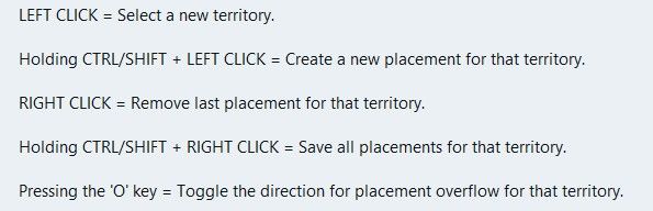
    image.jpeg

    .
    Wish list questions
    As the placement is based off center location it would be great if the app suggested moving the center coordinates to fit in more placments?
    What value upto would work, 27px as this is half the maximum height of the unit?
    Would the reiterations take to long? If so reduce the maximum pixels to move.
    If it made a suggestion then an option to do it. (right click menu option do it)

    .
    Save
    Before each save in Expert mode, a mapmaker needs to know what is going to be saved.
    This is critical if you accidentally change something unintended or forget you have changed something.
    A section that you can tick as read only/Dont save for each of the files to be saved.
    Especially the. xml as it messes with the order and formatting.
    The app should remember these setting from last save

    .
    Places (should be sorted & grouped, here is a suggested order)

    Units --- Capitals – I prefer a yellow star, not C Centers Comments Decorations Names PUs – should show the PU value as well as P, eg 6P Terrain Effects Victory Cities/Centers --- Blockade Convoy Kamikazi

    Places Options
    Right Click on TT/SZ for a menu to add/remove the items shown
    Left drag to move the selected item

    When there is no file or nothing to display, against the selection it should say None)

    .
    Earthquake
    The map gets shoved down and I lose my train of thought.
    There is a space reserved for shoving the map down to display things, like

    image.jpeg

    Can this space be reserved by moving up/compressing the ‘white’ space above the map, so the map does not move, please, pretty please.
    Yes this space will be ‘white’ space, but its better than moving the map.

    read more

  • @xxXEddieXxx said:

    @Vendetta it will disable itself automatically with a message to the user(you are on a big map there is no undo bla bla)

    Ah allright. I missed this post. I see there is not actually a limit: just the undo gets automatically disabled. That is good.

    read more

  • new update:

    A lot has changed since the first test version. Most of it comes straight from your feedback, so thank you for that.

    Territories and the map Places menu: show capitals, centers, convoys, names, PUs and the other markers on the map, several at once, drag them and save. Unit places: lay them out automatically (Squeeze as a spiral, or Grid), create the missing ones, or reload them from the files. Too many territories? Merge one into another, or remove many at once, smallest first. Split with a line and an Eraser for borders; a click erases a whole border between two territories. Islands can be clicked; before, the click chose the sea zone around them. Capital brush: a click moves a nation's capital. Units at the start: each row has a ×, and Remove all clears a territory. Resize map: make the whole map bigger or smaller, with everything on it. Export territory pictures: a PNG per territory, to draw over. Very large maps (eg 1941 GCD): borders can be drawn into them now. There is no undo for these lines, and the editor says so first. How the map looks Canals are clearly marked in their tool. Textures for the relief: premade ones, your own pictures, and Find textures in the map. Thht symbols now. Political view: land in its alliance's colour. Connections across the map's edge show as dashed lines. The Neighbours view no longer starts with a territory chosen. Place numbers hide when zoomed out. Nations, units and rules Rename a nation; its flags and unit pictures move with the next save. Has no capital for nations that are meant to have none. Flags from one picture, in all the sizes the game needs. Compare nations: territories, income, units and TUV side by side. New nations can buy the same as an existing one. Objectives: a tool of its own for national objectives. A nation's placing and moving rules in plain words. Stacking limits for unit types and for nations. Units panel rearranged; support to allies shows green, to enemies red. Terrain effects: values written with a count are read correctly now. Technology effects, buy window tabs and a Publish tool with a checklist. Easier to use Show all options in the File menu, for those who want everything open. Fine as it is: mark a problem or note that is meant so, and it is no longer counted. Check's tick stays after a save. The editor's version shows in the File menu and on the start page. A TripleA that is too old for the editor is told at the start, and the editor looks right under imbus. Maps that start in TripleA Every land territory gets its territory attachment, so a new map starts. Check and Play now start the game in memory and play its first round. Play opens TripleA only when that works, and says why when it does not. Nations without a capital no longer stop the game. Several edits that could break a game are fixed: splitting a territory, renaming one that a variable list names, adding an Activate Technology step. New problems are shown before you play, eg land units left in a sea zone. The "gamePlayer is null" crash came from TripleA loading two games at once; the editor now avoids that when it starts TripleA. Colours Nations, land without an owner and impassable land show in the colours TripleA uses. Other A Mac download

    https://github.com/xXEddieXxx/eddies-map-editor

    read more

  • @xxXEddieXxx Ok then just a setting for having/not having the undo feature (default having). I think it's quite important not forcing a maximum limit.

    read more